In 1811, more than 20 veteran pioneers gathered at Joseph Brooks' house, called together by summonses from the Bullitt Circuit Court to help relocate the old trace that had led from Bullitt's Lick to the Falls of the Ohio. It had fallen into disuse, and its location was key to titles to thousands of acres of disputed land. Robert McDowell wrote about it in 1962, in a newspaper article that we have transcribed on another page.
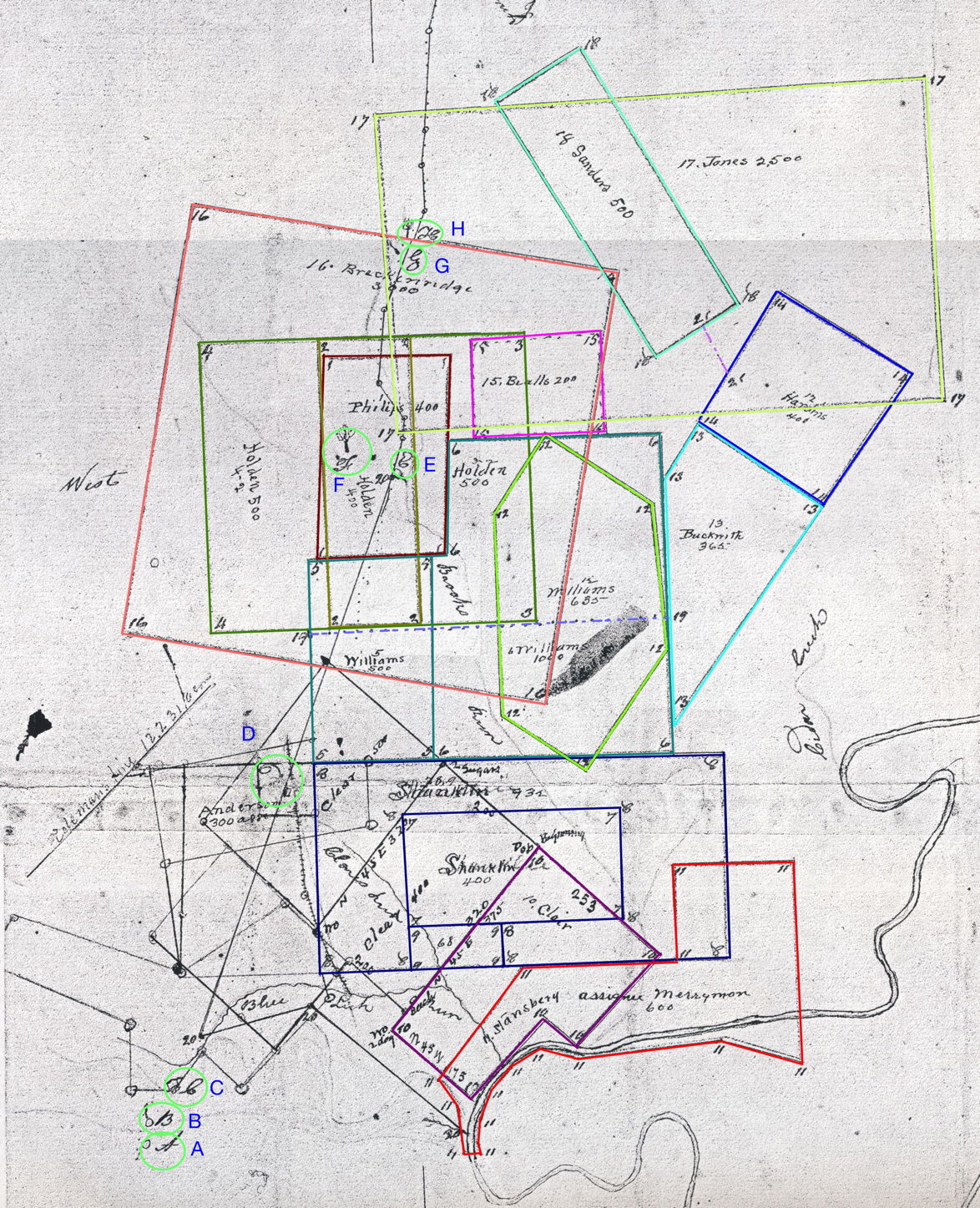
James Shanks was the county surveyor, and he prepared a composite plat drawing showing the locations of many of the disputed land claims, as well as the location of the old Wilderness Road. That plat is still available among the "T. C. Carroll" plats located in the Bullitt County Clerk's office in Shepherdsville.
The plat drawing is shown below, and has been annotated with colored lines to show the survey borders identified by Shanks. More information is available below the image. The image may take a bit of time to load as it is fairly large.

A full size image is available by following this link. Be aware that it is quite large. Also, you will need to use your BACK link to return here. Also note that clicking on that image will expand it to its full size.
Below are transcriptions of the texts of information Shanks included with the plat drawing. Please note that parts are difficult to read, and there may be errors in the transcription, particularly in some of the degree readings.
Shanks made a list of identified surveys on the plat drawing which are identified by number, as shown below.
Along the right side of the plat, he wrote the following statement, followed by an explanation of the sites identified by capital letters on the plat drawing.
August the 22d, 1811. Pursuant to an order from the Bullitt Circuit Court to me directed, I went on the land in controversy wherein Joseph Brooks is compt against Hawkins and other Defts in Chancery and have laid off the same as in the plat hereunto annexed.

Explanation
The penciled shade from Floyds fork extending westwardly past A. B. C. at the Blue Lick gap is the chain of knobs alluded to in the aforesaid depositions.
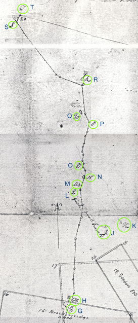
The crooked dotted line commencing at A. Extending thence Northwardly Brooks (alias Phelps, alias Stewarts) spring, the fish pools and to T. at the crossing of Fern Creek is the old trace alluded to in the aforesaid depositions and is the same shown to me by Adam Shepherd and John Burks in the suit of William Pope Junior and others against Stansberry and others, and again shown to me by Squire Boone and Charles Whitaker in the present suit.
At the bottom of the plat drawing, Shanks described "the meanders of the old trace leading from the Falls of Ohio to Bullitt's Lick." Again, please note that some of the degree or pole numbers may be wrong in this transcription, as it was difficult to read.
Beginning at the old crossing of Fern Creek running thence S 15 W 44 poles, S 30 E 370 poles, S 40 E 14 poles, S 68 E 125 poles, passing the Beech Spring, thence South 146 poles to the Indian graves, S 25 E 66 poles to the fork of the path leading to the falls of the Ohio and Beargrass, S 15 W 160 poles, S 14 E 22 poles, S 6 W 22 poles, S 15 E 22 poles, South 34 poles crossing a branch of the fish pool creek near the fork, S 12 W 36 poles to Colonel Moores Spring, S 11 W 64 poles to the fish pools making in the whole 1125 poles meander measure.
From the fish pools S 6 W 10 poles, S 4 W 92 poles, South 102 poles, S 33 W 22 poles, S 7 W 170 poles, S 10 W 110 poles, S 1 W 100 poles, S 30 W 44 poles, to a large white oak marked R. B. and three Elms on the East side of a draine of Brooks Run and on the West side of of the old trace, this being the beginning corner of 3000 acres surveyed for Robert Breckinridge assignee and upon John Edwards 3000 acre entry, making in the whole 650 poles meander measure and 640 poles on a direct line from the fish pools.
From Breckinridges northern boundary, thence S 15 W 30 poles to where George Kirtley and Walker Daniel were killed, S 14 W 96 poles, S 2 W 41 poles, S 28 E 72 poles, S 24 W 22 poles, S 14 W 62 poles to Brooks Spring, thence S 18 W 78 poles, S 28 W 42 poles, S 11 W 16 poles, S 18 W 78 poles, South 80 poles to where Colonel Floyd was wounded, S 22 W 72 poles, S 30 W 30 poles to Breckinridge's southern boundary line, making in the whole 719 poles meander measure and 692,8 poles on a direct line.
From Breckinridges southern boundary, S 20 W 150 poles, (Clares Station then bearing N 67 W 25 poles), S 11 W 34 poles, S 20 E 16 poles, S 33 W 28 poles (crossing Clares Run at 2 poles), S 20 W 96 poles, S 66 W 10 poles, S 26 W 82 poles (at 10 poles crossed Rocky Run), S 20 W 94 poles, S 22 W 75 poles, S 59 W 38 poles, S 37 W 36 poles to the North bank of the Blue Lick run (crossing the SWly corner of John Larue's 21,000 acre survey at 20 poles), S 41 W 54 poles, S 15 W 58 poles,(at 42 poles crossing the little Blue Lick), South 20 poles to the main Blue Lick at the Blue Lick gap of the knobs where the trace leading from the falls of Ohio to Bullitts lick passes through, making in the whole 791 poles meander measure.
Additional examination of this plat, and other information linked to this page, may provide corrections to what is presented here. A full-size photocopy of the original Shanks plat is available at the Bullitt County History Museum.
If you, the reader, have an interest in any particular part of our county history, and wish to contribute to this effort, use the form on our Contact Us page to send us your comments about this, or any Bullitt County History page. We welcome your comments and suggestions. If you feel that we have misspoken at any point, please feel free to point this out to us.
The Bullitt County History Museum, a service of the Bullitt County Genealogical Society, is located in the county courthouse at 300 South Buckman Street (Highway 61) in Shepherdsville, Kentucky. The museum, along with its research room, is open 10 a.m. to 4 p.m. Monday through Friday. Saturday appointments are available by calling 502-921-0161 during our regular weekday hours. Admission is free. The museum, as part of the Bullitt County Genealogical Society, is a 501(c)3 tax exempt organization and is classified as a 509(a)2 public charity. Contributions and bequests are deductible under section 2055, 2106, or 2522 of the Internal Revenue Code. Page last modified: 12 Sep 2024 . Page URL: bullittcountyhistory.org/bchistory/shanks1811.html