
This survey was #11 on the 1811 plat drawing by James Shanks, Bullitt County Surveyor, which is described on another page. Tracking down this survey and deed begins with a mistaken name on a treasury warrant. As you can see below, the warrant was made out in the name of Moses Merryman. But that was a mistake.
Virginia Treasury Warrant
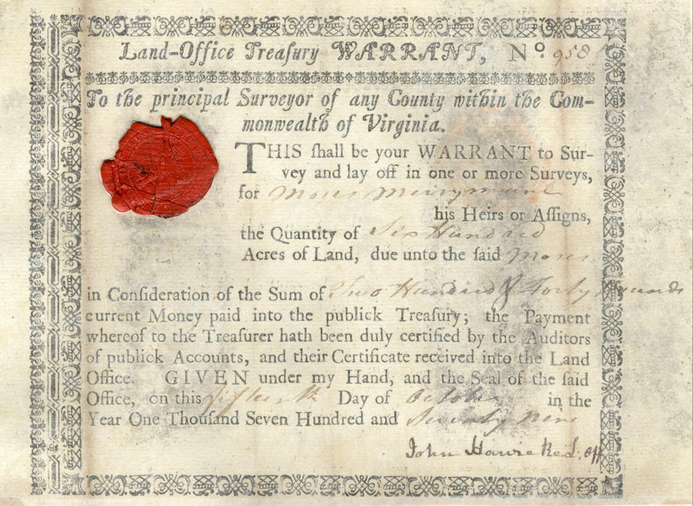
It should have been made out to Moses Lemmon. However, when Lemmon wanted to sell the warrant to Thomas Stansbury, there were two problems. Not only was the warrant not in his name, Moses Merryman was now deceased. To correct the problem, Lemmon sought out Joseph Merryman, who was the heir of Moses Merryman, and together they wrote the following indenture on 8 Nov 1788, which is transcribed here below its images.
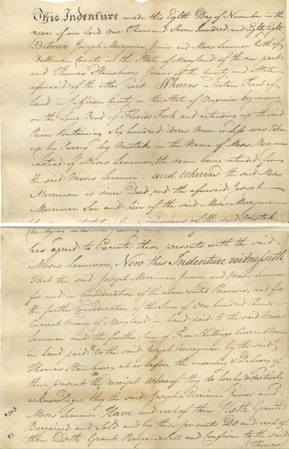
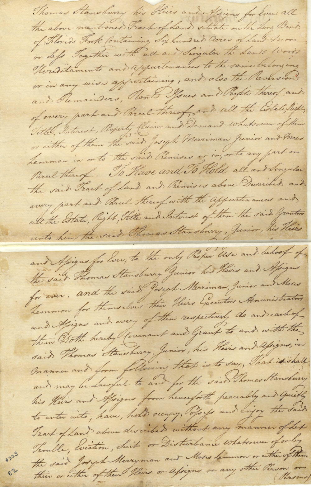
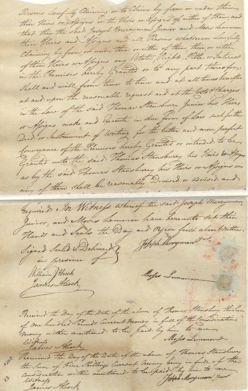
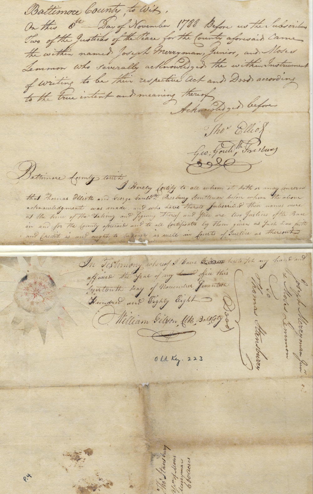
This indenture made this eighth day of November in the year of our Lord one thousand seven hundred and eighty eight between Joseph Merryman Junior and Moses Lemmon, both of Baltimore County in the state of Maryland of the one part and Thomas Stansbury Junior of the county and state aforesaid of the other part. Whereas a certain tract of land in Jefferson County in the state of Virginia beginning on the long bend of Florids Fork and extending up the said river containing six hundred acres more or less was taken up by survey by mistake in the name of Moses Merryman instead of Moses Lemmon, the same being intended for the said Moses Lemmon, and whereas the said Moses Merry man is since dead, and the aforesaid Joseph Merriman, son and heir of the said Moses Merryman (he dying intestate) being conscious of the said mistake has agreed to execute these presents with the said Moses Lemmon, now this indenture witnesseth that the said Joseph Merriman Junior and Moses Lemmon for and in consideration of the above recited premises, and for the further consideration of the sum of one hundred pounds current money of Maryland in hand paid to the said Moses Lemmon, and the further sum of five shillings current money in hand paid to the said Joseph Merryman by the said Thomas Stansbury at or before the ensealing & delivery of these presents to the receipt whereof they do hereby respectively acknowledge they the said Joseph Merriman Junior and Moses Lemmon have and each of them hath granted, bargained and sold and by these presents do and each of them doth grant, bargain, sell and confirm to the said Thomas Stansbury his heirs and assigns forever all the above mentioned tract of land situate on the long bend of Florids Fork containing six hundred acres of land more or less together with all and singular the lands, woods, hereditaments and appurtenances to the same belonging or in any wise appertaining, and also the reversions and remainders, rents, issues and profits thereof and of every part and parcel thereof and all the estate, right, title, interest, property, claim and demand whatsoever of them or either of them the said Joseph Merriman Junior and Moses Lemmon in or to the said premises or in or to any part or parcel thereof. T have and to hold all and singular the said tract of land and premises above described and every part and parcel thereof with the appurtenances and all the estate, right, title and interest of them the said grantors unto him the said Thomas Stansbury Junior, his heirs and assigns forever, to the only proper use and behoof of the said Thomas Stansbury Junior, his heirs and assigns forever, and the said Joseph Merriman Junior and Moses Lemmon for themselves, their heirs, executors, administrators and assigns and every of them respectively do and each of them doth hereby covenant and grant to and with the said Thomas Stansbury Junior, his heirs and assigns in manner and form following that is to say that it shall and may be lawful to and for the said Thomas Stansbury, his heirs and assigns from henceforth peaceably and quietly to enter into, have, hold, occupy, possess and enjoy the said tract of land above described without any manner of let trouble, eviction, suit or disturbance whatsoever of only the said Joseph Merryman and Moses Lemmon or either of them, their or either of their heirs or assigns or any other person or persons lawfully claiming or to claim by from or under them, their heirs or assigns or the heirs or assigns of either of them, and that they the said Joseph Merryman Junior and Moses Lemmon their heirs and assigns and all persons whatsoever lawfully claiming by, from, or under them or either of them their or either of their heirs or assigns any estate, right, title or interest in the premises hereby granted or to any part thereof shall and will from time to time and at all times hereafter at and upon the reasonable request and at the costs & charges in the law of the said Thomas Stansbury Junior his heirs or assigns make and execute in due form of law such further deed or instrument of writing for the better and more perfect conveyance of the premises hereby granted or intended to be granted unto the said Thomas Stansbury his heirs & assigns as by the said Thomas Stansbury his heirs and assigns or any of them shall be reasonably devised or advised and required. In witness whereof the said Joseph Merryman Junior and Moses Lemmon have hereunto set their hands and seals the day and year first above written. (signed) Joseph Merryman Junior, Moses Lemmon; in presence of William J. Alcock, James Alcock
It would be four years later that the actual survey was made by James F. Moore on 3 Nov 1792, as shown below.
Survey
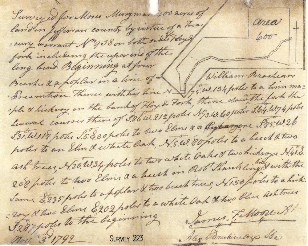
Surveyed for Moses Merryman 600 acres of land in Jefferson county by virtue of a treasury warrant No. 958 on both sides of Floyd's Fork including the upper end of the long bend. Beginning at four beeches & a poplar in a line of William Brashear's preemption, thence with his line N 75° W 134 poles to a linn maple & hickory on the bank of Floyd's Fork, thence down the fork the several courses thereof S 86° W 212 poles, N 73 W 60 poles, S 64° W 74 poles, S 31° W 118 poles, S 5° E 30 poles to two elms & a sycamore, S 85° W 26 poles to an elm & white oak, N 5° W 80 poles to a beech & two ash trees, N 30° W 34 poles to two white oaks & two hickories, N 41° E 208 poles to two elms & a beech in Robt Shanklin's line & with the same E 235 poles to a poplar & two beech trees, N 150 poles to a hickory & two elms, E 202 poles to a white oak & two blue ash trees, S 287 poles to the beginning. Nov. 3rd 1792. James F. Moore, assistant surveyor
Thomas Stansbury would finally get his deed to the land the following May.
Deed
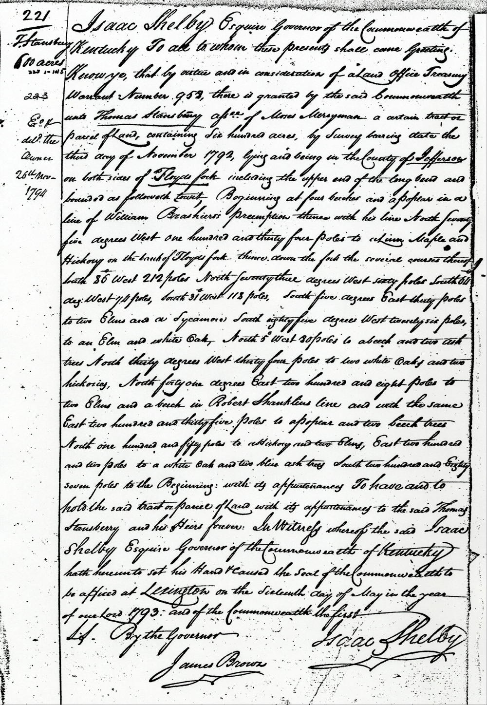
Isaac Shelby Esquire, Governor of the Commonwealth of Kentucky, to all to whom these presents shall come, greeting. Know ye, that by virtue and in consideration of a land office treasury warrant Number 952, there is granted by the said Commonwealth unto Thomas Stansbury, assignee of Moses Merryman, a certain trat or parcel of land containing six hundred acres by survey bearing date the third day of November 1792, lying and being in the county of Jefferson on both sides of Floyd's Fork including the upper end of the long bend and bounded as followeth, to wit. Beginning at four beeches and a poplar in a line of William Brashear's preemption, thence with his line North seventy five degrees West one hundred and thirty four poles to a Linn Maple and hickory on the bank of Floyd's Fork, thence down the fork the several courses thereof South 86° West 212 poles, North seventy three degrees West sixty poles, South 64 degrees West 74 poles, South 31° West 118 poles, South five degrees East thirty poles to two elms and a sycamore, South eighty five degrees West twenty six poles to an elm and white oak, North 5° West 80 poles to a beech and two ash trees, North thirty degrees West thirty four poles to two white oaks and two hickories, North forty one degrees East two hundred and eight poles to two elms and a beech in Robert Shanklin's line and with the same East two hundred and thirty five poles to a poplar and two beech trees, North one hundred and fifty poles to a hickory and two elms, East two hundred and two poles to a white oak and two blue ash trees, South two hundred and eighty seven poles to the beginning, with its appurtenances, to have and to hold the said tract or parcel of land with its appurtenances to the said Thomas Stansberry and his heirs forever. In witness whereof the said Isaac Shelby Esquire, Governor of the Commonwealth of Kentucky, hath hereunto set his hand and caused the seal of the Commonwealth to be affixed at Lexington on the sixteenth day of May in the year of our Lord 1793, and of the Commonwealth the first. (signed) Isaac Shelby
If you, the reader, have an interest in any particular part of our county history, and wish to contribute to this effort, use the form on our Contact Us page to send us your comments about this, or any Bullitt County History page. We welcome your comments and suggestions. If you feel that we have misspoken at any point, please feel free to point this out to us.
The Bullitt County History Museum, a service of the Bullitt County Genealogical Society, is located in the county courthouse at 300 South Buckman Street (Highway 61) in Shepherdsville, Kentucky. The museum, along with its research room, is open 10 a.m. to 4 p.m. Monday through Friday. Saturday appointments are available by calling 502-921-0161 during our regular weekday hours. Admission is free. The museum, as part of the Bullitt County Genealogical Society, is a 501(c)3 tax exempt organization and is classified as a 509(a)2 public charity. Contributions and bequests are deductible under section 2055, 2106, or 2522 of the Internal Revenue Code. Page last modified: 12 Sep 2024 . Page URL: bullittcountyhistory.org/bchistory/thomas-stansbury600.html