
In an 1831 court case described on another page, a survey of land for John Larue was in dispute. We have located a deed that refers to that survey.
Here is a transcription of the original land deed that granted the heirs of John Larue a tract of 21,000 acres lying mostly in present day Bullitt County, but extending northward into southern Jefferson County today.
Significant landmark descriptions are highlighted in the document, and those marked on the Google map below are indicated with red letters.
Isaac Shelby Esquire Governor of the Commonwealth of Kentucky To all to whom these presents shall come Greeting. Know ye that by virtue and in consideration of two land office Treasury warrants number 14139 and 14786 there is granted by the said Commonwealth unto the heirs of John Larue Decd a certain tract or parcel of land containing twenty one thousand acres by survey bearing date the third day of August one thousand seven hundred and ninety two lying and being in the County of Jefferson and bounded as followeth towit. Beginning at the mouth of a small branch where the knobs come to Floyds fork above Nicholas Brashear's on the north side of said Knobs at a hickory, maple and white walnut standing on the bank of Floyds fork running up with the meander and binding on said fork on the west or lower side the following courses, North 8° East 16 poles, North 38° East 60 poles, North 25° East 40 poles, North 46° East 40 poles, North 85° East 30 poles, North 61° East 30 poles, South 64° East 40 poles, South 75° East 12 poles, North 89° East 40 poles, North 74° East 32 poles, North 85° East 176 poles, North 65° East 25 poles, East 66 poles, South 62° East 14 poles, North 87° East 84 poles, North 56° East 34 poles, North 31° West 20 poles, North 48° West 26 poles, North 73° West 22 poles, North 50° West 22 poles, North 10° West 16 poles, North 55° East 30 poles, South 72° East 32 poles, North 61° East 22 poles, North 15° East 86 poles, North 1.5° West 10 poles, North 14° East 10 poles, North 48° East 35 poles, North 37° East 24 poles, West 26 poles, South 65° West 123 poles, North 65° West 20 poles, North 31° West 60 poles, North 21° East 16 poles, North 37° East 20 poles to a sugar tree twelve poles above where the old road crosses Floyds fork from the falls of Ohio to the mouth of Coxes Creek marked I.B. North 30° West 34 poles, North 5° East 24 poles, North 26° East 80 poles, North 56° East 56 poles, North 40° East 124 poles, North 36° West 152 poles, North 11° East 32 poles, East 24 poles, South 62° East 193 poles, North 55° East 48 poles, North 8° West 222 poles, South 72° East 120 poles, South 13° East 92 poles, North 50° East 122 poles, South 47° East 120 poles, South 6° West 93 poles, South 35° East 115 poles, North 32° East 82 poles to where the waggon road from the Falls of Ohio to Beards town crosses Floyds fork thence North 15° West 151 poles, North 15° East 66 poles, North 33° East 24 poles, North 67° East 80 poles, North 96 poles to a large hoopwood and a large beech standing on the bank of Floyds fork,[A] thence North 72° West 2655 poles to two ashes and two elms standing on the south bank of Fern creek where the old road from Bullits lick to the falls of Ohio cross said creek thence with the road[B] South 25° East 610 poles, South 41° West 20 poles, South 13° West 30 poles, South 5° East 14 poles, South 3.5° West 21 poles, South 19° East 10 poles, South 3.5° East 38 poles, South 2.5° West 62 poles to Col Moores spring [C] and the same course continued 228 poles, South 17° West 103 poles, South 100 poles, South 18° East 152 poles, South 13° West 448 poles to Brooks Spring [D] South 20° West 934 poles to two beeches gum walnut & elm standing on the east side of said road in a flat on the northwest side of a branch thence with the Knobs [E] North 73° East 180 poles, South 49° East 320 poles to the beginning with its appurtenances to have and hold the said tract or parcel of land with its appurtenances to the said heirs of John Larue Decd, and their heirs forever. In witness whereof the said Isaac Shelby Equire Governor of the Commonwealth of Kentucky hath here unto set his hand and caused the seal of the Commonwealth to be affixed at Lexington on the sixteenth day of May in the year of our Lord one thousand seven hundred and ninety three and of the Commonwealth the first.
Isaac Shelby
Below we have placed an image of the original survey drawing on the left, and an image insert from Google showing the approximate location of this survey on the right. Please note that the locations of borders are only rough estimates. This side by side comparison will allow you to see the shape of the survey both ways.
You can use the arrows in the upper left corner of the Google map to move the map image, or use the plus and minus signs to zoom in or out. You may also put the cursor on the map and drag the image to where you want it.
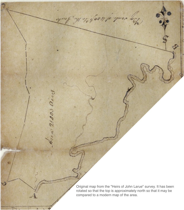
An image of the original survey, and a larger Google map showing the survey on a modern map may be viewed on another page.
If you, the reader, have an interest in any particular part of our county history, and wish to contribute to this effort, use the form on our Contact Us page to send us your comments about this, or any Bullitt County History page. We welcome your comments and suggestions. If you feel that we have misspoken at any point, please feel free to point this out to us.
The Bullitt County History Museum, a service of the Bullitt County Genealogical Society, is located in the county courthouse at 300 South Buckman Street (Highway 61) in Shepherdsville, Kentucky. The museum, along with its research room, is open 10 a.m. to 4 p.m. Monday through Friday. Saturday appointments are available by calling 502-921-0161 during our regular weekday hours. Admission is free. The museum, as part of the Bullitt County Genealogical Society, is a 501(c)3 tax exempt organization and is classified as a 509(a)2 public charity. Contributions and bequests are deductible under section 2055, 2106, or 2522 of the Internal Revenue Code. Page last modified: 10 May 2026 . Page URL: bullittcountyhistory.org/bchistory/heirslarue.html