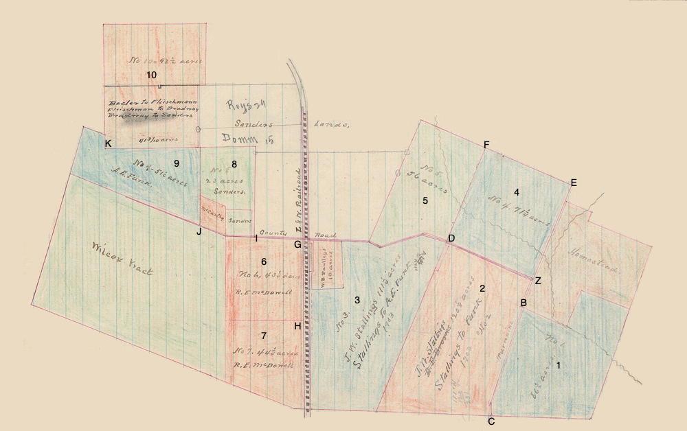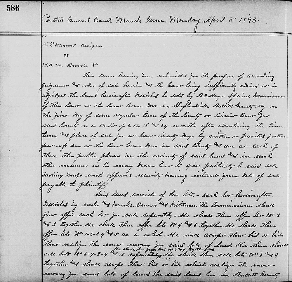
On 3 Apr 1893, the Bullitt Circuit Court issued the order shown below to facilitate the sale of land belonging to W. B. M. Brooks as divided into 10 lots. Then on 12 Sep 1893, Special Commissioner R. F. Hays sold the various lots which are shown in the drawing below. The deeds for those sales are linked in the text below. Note that the metes and bounds of each lot described below do not always agree with those shown on the deeds.

Bullitt Circuit Court Order Book 2, Pages 586-588
Bullitt Circuit Court March Term, Monday, April 3rd 1893
W. T. Morrow, assignee vs W. B. M. Brooks &c
This cause having been submitted for the purpose of amending judgment and order of sale herein, and the court being sufficiently advised, it is adjudged the land hereinafter described be sold by R. F. Hays, special commissioner of this court, at the court house door in Shepherdsville, Bullitt County, Kentucky on the first day of some regular term of the County or Circuit Court for said County on a credit of 6, 12, 18 and 24 months after advertising the time terms and place of sale for at least twenty days by written or printed posters put up on at the court house door in said County and also at each of three other public places in the vicinty of said lands, and in such other manner as he may deem best to give publicity to said sale, taking bonds with approved security, having interest from date of sale payable to plaintiff.
Said land consists of ten lots, each lot hereinafter described by metes and bounds, course and distances. The Commissioner shall first offer each lot for sale separately. He shall then offer lots No. 2 and 3 together. He shall then offer lots No 4 and 5 together. He shall then offer lots No. 1-2-3-4 and 5 as a whole. He will accept that bid or bids that realizes the most money for said lots of land. He then shall sell lots No. 6-7-8-9 and 10 separately. He shall then sell lots No. 6 and 7 together and he shall then sell lots No. 8 and 9 together and shall accept that bid or bids which realizes the most money for said lots of land. The said land lies in Bullitt County, Kentucky, and is described as follows.
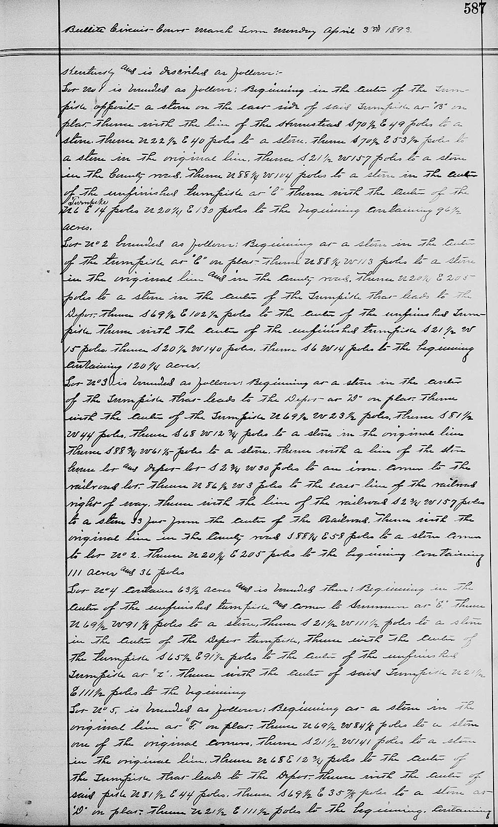
Lot No. 1 is bounded as follows: Beginning in the center of the turnpike opposite a stone on the east side of said turnpike at "B" on plat; thence with the line of the Homestead South 70 1/2° East 49 poles to a stone; thence North 22 1/2° East 40 poles to a stone; thence South 70 1/2° East 53 1/2 poles to a stone in the original line; thence South 21 1/2° West 157 poles to a stone in the county road; thence North 88 1/4° West 104 poles to a stone in the center of the unfinished turnpike at "C" thence with the center of the turnpike North 6° East 14 poles, North 20 1/4° East 130 poles to the beginning containing 96 1/2 acres.
Lot No. 2 bounded as follows: Beginning a a stone in the center of the turnpike at (C) on plat; thence North 88 1/4° West 113 poles to a stone in the original line and in the county road; thence North 20 1/4° East 205 poles to a stone in the center of the turnpike that leads to the depot; thence South 69 1/2° East 102 1/2 poles to the center of the unfinished turnpike; thence with the center of the unfinished turnpike South 21 1/2° West 15 poles; thence South 20 1/2° West 140 poles; thence South 6° West 14 poles to the beginning containing 120 1/4 acres.
Lot No. 3 is bounded as follows: Beginning at a stone in the center of the turnpike that leads to the depot at "D" on plat; thence with the center of the turnpike North 69 1/2° West 23 1/2 poles; thence South 81 1/2° West 44 poles; thence South 68° West 12 3/4 poles to a stone in its original line; thence South 88 3/4° West 61 1/5 poles to a stone; thence with a line of the store house lot and depot lot South 2 3/4° West 30 poles to an iron corner to the railroad lot; thence North 86 1/2° West 3 poles to its east line of the railroad right of way; thence with the line of the railroad South 2 3/4° West 157 poles to a stone 33 feet from the center of the railroad; thence with the original line in the county road South 88 1/4° East 58 poles to a stone, corner to lot No. 2; thence North 20 1/4° East 205 poles to the beginning containing 111 acres and 36 poles.
Lot No. 4 contains 63 1/2 acres and is bounded thus: Beginning in the center of the unfinished turnpike, and corner to Summers at "E"; thence North 69 1/2° West 91 1/8 poles to a stone; thence South 21 1/2° West 111 1/2 poles to a stone in the center of the depot turnpike; thence with the center of the turnpike South 65 1/2° East 91 1/2 poles to the center of the unfinished turnpike at "Z"; thence with the center of said turnpike North 21 1/2° East 111 1/2 poles to the beginning.
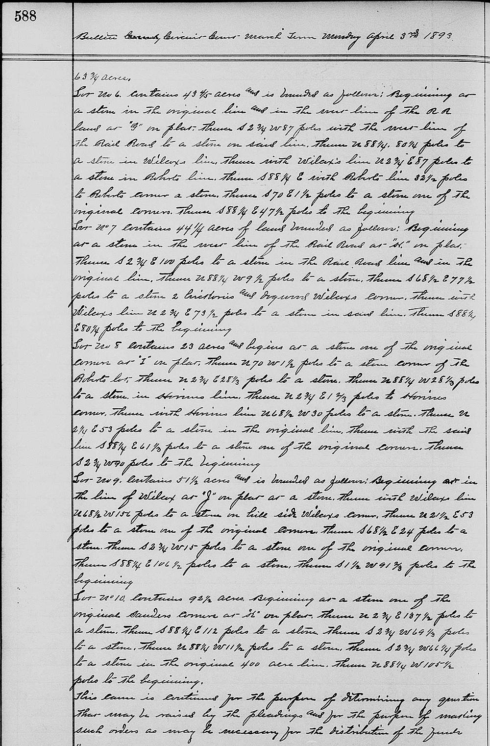
Lot No. 5 is bounded as follows: Beginning at a stone in the original line at "F" on plat; thence North 69 1/2° West 84 1/8 poles to a stone, one of the original corners; thence South 21 1/2° West 141 poles to a stone in the original line; thence North 68° East 12 3/4 poles to the center of the turnpike that leads to the depot; thence with the center of said pike, North 81 1/2° East 44 poles; thence South 69 1/2° East 35 7/8 poles to a stone at "D" on plat; thence North 21 1/2° East 111 1/2 poles to the beginning, containing 63 3/4 acres.
Lot No. 6 contains 43 4/5 acres and is bounded as follows: Beginning at a stone in the original line and in the West line of the railroad land at "G" on plat; thence South 2 3/4° West 87 poles with the West line of the railroad to a stone in said line; thence North 88 1/4° West 80 1/4 poles to a stone in Wilcox's line; thence with Wilcox's line North 2 3/4° East 87 poles to a stone in Robert's line; thence South 88 1/4° East with Robert's line 32 1/2 poles to Robert's corner, a stone; thence South 70° East 1 1/2 poles to a stone, one of the original corners; thence South 88 1/4° East 47 1/2 poles to the beginning.
Lot No. 7 contains 44 1/4 acres of land bounded as follows:. Beginning at a stone in the west line of the railroad at "H" on plat; thence South 2 3/4° East 100 poles to a stone in the railroad line and in the original line; thence North 88 1/4° West 9 1/2 poles to stone; thence South 68 1/2° East 77 1/2 poles to a stone, two hickory and dogwood, Wilcox's corner; thence with Wilcox's line North 2 3/4° East 73 1/2 poles to a stone in said line; thence South 88 1/4° East 80 1/4 poles to the beginning.
Lot No. 8 contains 23 acres and begins at a stone, one of the original corners at "I" on plat; thence North 70° West 1 1/2 poles to a stone, corner of the Robert's lot; thence North 2 3/4° East 28 1/3 poles to a stone; thence North 88 1/4° West 28 1/3 poles to a stone in Horine's line; thence North 2 3/4° East 1 2/3 poles to Horine's corner; thence with Horine's line North 68 1/2° West 30 poles to a stone; thence North 2 1/4° East 53 poles to a stone in the original line; thence with said line South 88 1/4° East 61 1/3 poles to a stone, one of the original corners; thence South 2 3/4° West 90 poles to the beginning.
Lot No. 9 contains 51 1/2 acres and is bounded as follows: Beginning in the line of Wilcox at "J" on plat at a stone; thence with Wilcox's line North 68 1/2° West 156 poles to a stone on hill side, Wilcox's corner; thence North 21 1/2° East 53 poles to a stone, one of the original corners; thence South 68 1/2° East 24 poles to a stone; thence South 2 3/4° West 15 poles to a stone, one of the original corners; thence South 88 1/4° East 106 1/2 poles to a stone; thence South 1 1/2° West 91 2/3 poles to the beginning.
Lot No. 10 contains 92 1/2 acres. Beginning at a stone, one of the original Sanders' corners at "K" on plat; thence North 2 3/4° East 137 1/2 poles to a stone; thence South 88 1/4° East 112 poles to a stone; thence South 2 3/4° West 69 1/3 poles to a stone; thence North 88 1/4° West 11 1/2 poles to a stone; thence South 2 3/4° West 66 1/4 poles to a stone in the original 400 acre line; thence North 88 1/4° West 105 1/2 poles to the beginning.
This cause is continued for the purpose of determining any question that may be raised by the pleadings and for the purpose of make such orders as may be necessary for the distribution of the funds.


If you, the reader, have an interest in any particular part of our county history, and wish to contribute to this effort, use the form on our Contact Us page to send us your comments about this, or any Bullitt County History page. We welcome your comments and suggestions. If you feel that we have misspoken at any point, please feel free to point this out to us.
The Bullitt County History Museum, a service of the Bullitt County Genealogical Society, is located in the county courthouse at 300 South Buckman Street (Highway 61) in Shepherdsville, Kentucky. The museum, along with its research room, is open 10 a.m. to 4 p.m. Monday through Friday. Saturday appointments are available by calling 502-921-0161 during our regular weekday hours. Admission is free. The museum, as part of the Bullitt County Genealogical Society, is a 501(c)3 tax exempt organization and is classified as a 509(a)2 public charity. Contributions and bequests are deductible under section 2055, 2106, or 2522 of the Internal Revenue Code. Page last modified: 04 Jan 2025 . Page URL: bullittcountyhistory.org/bchistory/wbmbrooks-circuitcourt.html