
In 1956, Robert McDowell read a paper before the Filson Club in which he identified a number of individuals who had surveys of land made along Long Lick Creek including Parmenas Briscoe, Peter Phillips, Charles Chinn, Henry Spillman and John Cocky Owings, John Bowman, John May and Mark Oyler, Benjamin Frye, Jacob Myer, and John Friggs. A transcription of his paper is located on another page.
We have located many of these online at the Kentucky Secretary of State's Kentucky Land Office, and have tried to put together a composite drawing of where many of them were located with regard to the others. To do this we have identified eleven surveys that identify parts of their boundaries as being on or next to one or more of the others.
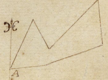
The drawing below shows these surveys drawn to show their relationships.
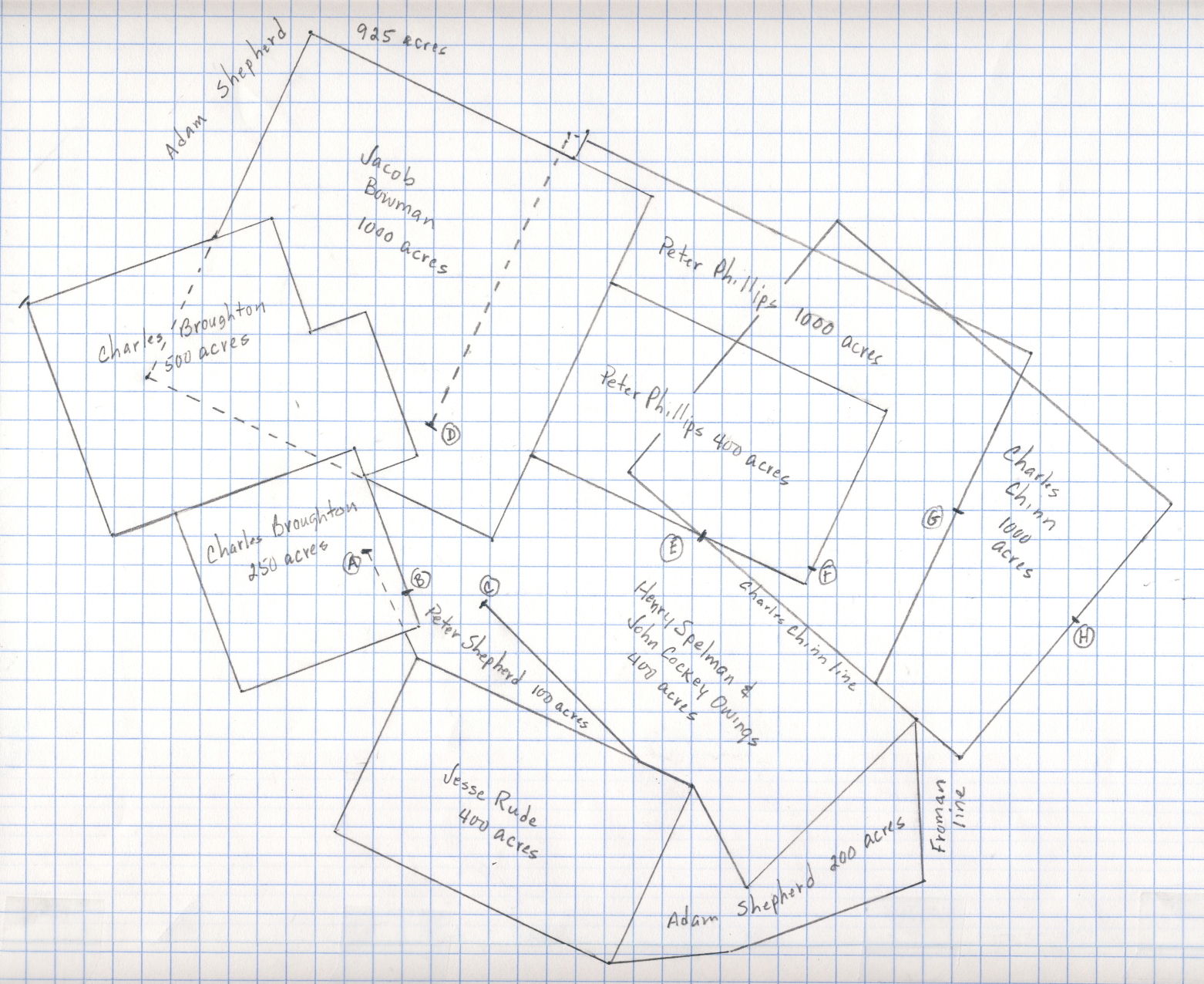
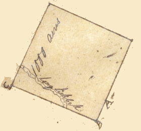
We begin with the two surveys of Charles Broughton. His 250 acre survey was sold to Henry Crist and Adam Shepherd in December 1801. A survey of it appears under their names, as transcribed below from the Kentucky Grant Book 2, page 137.
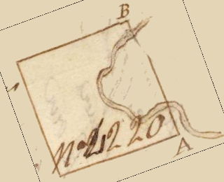
"... Beginning at a white oak and three hickories standing on the south bank of Long Lick Creek, about forty poles above where the said Broughton erected a salt works on the said creek, thence north twenty degrees west thirty eight poles to Long Lick Creek and the course continued on all two hundred poles to a hickory, elm and white oak on the south side of the said creek, south seventy degrees west two hundred poles to a red oak and two hickories, thence south twenty degrees east two hundred poles to a beech gum and black oak on the side of the knobs, thence north seventy degrees east two hundred poles to the Beginning..."
The image shows a drawing of the survey taken from the survey document itself. It shows where the surveyor believed the path of Long Lick Creek to be. On the drawing above, the letter B marks the location of where the survey states that the boundary line crossed the creek.
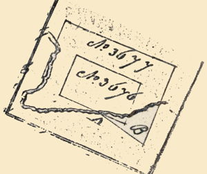
Broughton's 500 acre survey is described below.
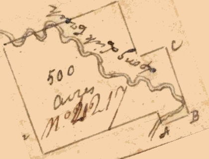
"Beginning at two large white oaks standing on the line of said Broughtons 250 acre survey and on the North side of the Creek thence N 70 E 60 poles to a red oak and elm and white oak thence N 20 W 160 poles to a large white oak thence S 70 W 60 poles to two black oaks thence N 20 W 130 poles to three white oaks on a ridge thence S 70 W 271 poles to a beech, white oak and black oak on the south side of the creek thence S 20 E 260 poles to a white oak, black oak and hickory thence N 70 E 71 poles to two hickories and red oak S.W. corner of said Broughton 250 acres survey thence with said line N 70 E 200 pole to a hickory, elm and white oak Northwest corner of said survey thence S 20 E 30 pole to the Beginning."
The image shows a drawing of the survey taken from the survey document itself. It shows where the surveyor believed the path of Long Lick Creek to be within that survey.
More detailed information about the Broughton surveys is available on another page.
The next problem was to connect the Broughton surveys with any of the others. This was accomplished by referring to a survey of 925 acres done for Adam Shepherd in September 1798. That survey lay to the north of the Broughton surveys and identified a line that it shared with Broughton's 500 acre survey. It also identified lines it shared with a Bowman survey and a Phillips survey, as described below.
"Beginning at Charles Broughton's corner of beech, white oak and black oak on the south bank of Long Lick Creek, thence with Broughton's line north seventy degrees east two hundred and eight poles to a line of Bowman's upper one thousand acres survey thence with Bowman's line north twenty five degrees east two hundred and thirty eight poles to his corner of two white oaks and black oak, thence with another of his lines south sixty five degrees east three hundred and eight poles to a line of Peter Philips' one thousand acre presumption, thence with Philips' line north twenty five degrees east thirty poles to his corner of white oak, black oak and a pine..."
More information about this Shepherd survey is located on another page.
The overall shape of this survey is shown below in a drawing taken from the original survey. The lines described above are along the bottom edge, and can be seen in the initial drawing above. From this we are able to locate the Bowman entry as well.
We located a 1000 acre survey for Jacob Bowman dated in June 1793 which appears to be the Bowman entry described in Shepherd's survey. It shares lines with Peter Philips, and has lines that match two of Shepherd's lines in direction. It is described below. You may also find more information about Jacob Bowman's survey on another page.
"Beginning at a sugar tree and beech the south west corner of Peter Philips' 400 acre settlement running thence S 25 W 100 poles to two beeches thence N 65 W 400 poles to a hickory and two white oaks thence N 25 E 400 poles to two white oaks and black oak thence S 65 E 400 poles to two black oaks and red oak thence S 25 W 100 poles to two beeches corner to said settlement thence with a line of the same S 25 W 200 poles to the Beginning."
As you can see from the plat drawing to the right which was taken from the original survey, Bowman's lines fit nicely with those of Shepherd. The letter A on the drawing marks the beginning of the survey, and the lines continue clockwise. Note also that his survey marks the location of the Long Lick Creek as it passes through the survey. The letter A also marks "the south west corner of Peter Philips' 400 acre settlement." This gives us our next clue.
In June 1784, Peter Philips had two surveys done, one for four hundred acres, and the second for one thousand acres which surrounded the first survey on three sides. More information about this is located on another page.
Since Bowman's survey identifed the location of the southwest corner of Philip's 400 acre survey, we are able to position it as shown in the initial drawing above.
The image to the left shows the original plat drawing of both surveys, rotated to its approximate location relative to compass direction with north being at the top. Note also the apparent location of Long Lick Creek with regard to these surveys.
Two things to note: the 400 acre survey identifies its starting point (point A on the plat drawing above, and point E on the initial drawing above) as "at a sugartree and elm standing on the west bank of Long Lick Creek about one mile on a direct line above Long Lick North East corner to John Cockey Owing's 400 acre survey..." and the 1000 acre survey begins at the same point and runs with "the line of John Cocky Owing's 400 acre survey." Thus we can identify both a corner and a line of Owing's survey. Also note that Philip's surveys identify two other points where his lines cross Long Lick Creek (points F and G on the initial drawing above).
The Owings 400 acre survey was actually in the name of Henry Spelman and John Cockey Owings, and they sold it to Adam Shepherd soon after the survey was made. More information about it is available on another page. You can follow the survey described below on the plat image to the right which was taken from the original survey.
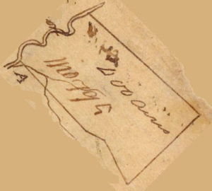
"Beginning at a white oak and gum standing on the bank of Long Lick Creek about thirty poles above the mouth of Cunningham's spring branch, thence running up the creek binding on the same with the meanders thereof three hundred and sixteen poles to a sugar tree and elm in the line of Charles Chin's one thousand acre survey, thence along the said Chin's line south fifty degrees east three hundred poles to two beaches and a large poplar on a ridge, thence south forty five degrees west two hundered and fifty poles to two ashes and a walnut at a sinking branch, thence north twenty eight degrees west one hundred and twenty poles to three beaches a corner of Jesse Rude's four hundred acre survey, thence along his line north sixty five degrees west sixty poles to a while oak and beach, thence leaving the said Rude's line north forty five degrees west two hundred and thirty four poles to the Beginning."
Note that this survey identifies two others: Charles Chinn's 1000 acre survey, and Jesse Rude's 400 acre survey. Since Rude's survey was easier to plot, we will discuss it first.
As you can see on the initial drawing at the top if this page, Jesse Rude's 400 acres were laid out in a retangular shape that touched Spelman and Owings' survey for a short distance on one side. You can read more about Rude's survey on another page.
In January 1786 a survey of 100 acres in the name of Peter Shepherd, likely commissioned by his son Adam Shepherd, was recorded along Long Lick Creek. We know its location because it clearly identifies one side as being with Jesse Rude, and another side with Spilman and Owings as drawn in the plat image to the right and transcribed below.
"Beginning at Jesse Rude most north east corner of his 400 acre presumption, at a small white oak & a gum, thence S 65 E 260 poles to a white oak and beech corner to Spilman and Owins presumption of 400 acres. Thence N 45 W 234 poles with the said Spilman & Owins line to their beginning corner on the bank of Long Lick Creek, white oak & gum. Thence down the creek binding on the same with the meanders thereof 139 poles, when reduced to a strait line to a black oak on the north side of the creek on the bank, thence S 26 E 125 poles to the beginning."
More information about this survey may be found on another page.
Adam Shepherd claimed another tract of land containing 200 acres in 1798. This was located south of Jesse Rude's 400 acres and of Spilman and Owings' 400 acres as described below, and drawing in the image to the right.
"Beginning at Jesse Rudes southwesterly corner of 2 poplars, 3 dogwoods and beech (the former corner of sweet gum and beech being down) thence N 84 E 124 poles to a forked beech, thence N 70 E 220 poles to 2 beeches in Froman's line, thence with Froman's line N 5 W 165 poles to Spilmans corner of popler and 2 beeches, thence with Spilmans line S 45 W 250 poles to 2 ashes and walnut, thence with another line N 28 W 12 poles to Jesse Rude's southeasterly corner of 2 beeches, thence with Rude's line S 25 W 200 poles to the beginning."
The relationships of these surveys to one another can be seen in the initial drawing at the top of this page. You can read more about this Adam Shepherd survey on another page.
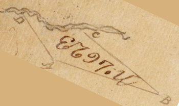
The last survey that we have included in our drawing is that of Charles Chinn who claimed 1000 acres in February 1783. Determining the location of that survey with regard to the others in our drawing has been somewhat problematic. We know that Spilman and Owings' survey followed Long Lick Creek to a point where Chinn's line crossed the creek, and that their line then followed his line for 300 poles is a southeasterly direction before turning away. The challenge was to determine where on Chinn's line this was. As shown in the survey description below, this survey's third leg ran in a southeasterly direction that matches that of Spilman and Owings. Moreover, it notes that that line crossed Long Lick Creek at the 100 pole mark.
"Beginning at two large white oaks and a poplar standing on the south of the Knobs running thence N 50 W 460 poles to a slooping gum and a small black oak, thence S 40 W 348 poles to an ash, beech and spanish oak standing on a small nole then S 50 E 460 poles crossing Long Lick Creek at 100 poles to a large poplar and a beech tree standing in a flatt, thence North 40 E 348 poles crossing the creek at 188 poles to the beginning."
If we assume that the place where Chinn's line crossed the creek was the same place where Spilman and Ownings' line left the creek, then we can safely draw the rest of Chinn's survey as shown in the initial drawing above. Also note that Chinn's survey identifies another place where his line crosses the Creek which we have identified as point H on the drawing.
Additional information about Charles Chinn's survey may be found on another page.
Of the others that Robert McDowell identified as having surveys along Long Lick Creek, we have found information on several of them, but have not yet been able to positively determine where they were located. As we continue to research this, additional information may be added to this page.
If you, the reader, have an interest in any particular part of our county history, and wish to contribute to this effort, use the form on our Contact Us page to send us your comments about this, or any Bullitt County History page. We welcome your comments and suggestions. If you feel that we have misspoken at any point, please feel free to point this out to us.
The Bullitt County History Museum, a service of the Bullitt County Genealogical Society, is located in the county courthouse at 300 South Buckman Street (Highway 61) in Shepherdsville, Kentucky. The museum, along with its research room, is open 10 a.m. to 4 p.m. Monday through Friday. Saturday appointments are available by calling 502-921-0161 during our regular weekday hours. Admission is free. The museum, as part of the Bullitt County Genealogical Society, is a 501(c)3 tax exempt organization and is classified as a 509(a)2 public charity. Contributions and bequests are deductible under section 2055, 2106, or 2522 of the Internal Revenue Code. Page last modified: 12 Sep 2024 . Page URL: bullittcountyhistory.org/bchistory/longlicksurveys.html