
The following was originally published in The Filson Club History Quarterly, Volume 30, No. 3 (July, 1956). It is reprinted here by permission from Robert E. McDowell, Jr., and the Filson Club. The content is copyright 2006 by Robert E. McDowell, Jr., Louisville KY. All rights are reserved. No part of the content of this page may be included in any format in any place without the written permission of the copyright holder.
by Robert E. McDowell Louisville, Kentucky
A paper read before The Filson Club, May 7, 1956
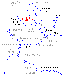
There is a region just south of Louisville, [see map] roughly the size of a small county, that was probably the most important—the most notorious section in the entire state of Kentucky during pioneer times. Geographically it commences a little north of Fairdale and runs southward along the eastern foot of the Knobs, crossing Salt River and extending on as far south as Bardstown Junction in Bullitt County.
The heart of this region was Bullitt's Lick and it derived its importance from salt.
Today we take salt more or less for granted. But in early days salt was a very precious, a very necessary article. For one thing, it was almost the only preservative. The early settlers had to have salt in order to pickle their beef, cure their pork, salt down their deer and bear meat. Since game was their principal source of food, without salt to preserve it they would have starved.
Even had it been practical to transport salt across the mountains, the eastern communities could not have supplied it. The Revolutionary War with Great Britain had cut off the normal sources of salt. The Virginia Gazette of the period is full of notices reflecting their distress: reports of planters who experimented with boiling down sea water; act after act passed by the Revolutionary legislature to encourage the manufacture of salt; bold type notices whenever a shipment of salt managed to slip through the British blockade.
In the wilderness the shortage was even more acute. The settlers were able to boil down a little at the numerous licks and salt springs for their personal use. In 1778 Daniel Boone was captured by Indians with a party of men at the lower Blue Licks as they were engaged in making salt for Boonesboro. 1 But this was only the barest trickle. Some adequate source of salt had to be found.
Without it, the settlement of Kentucky would have been retarded for years.
This was the situation, then, when in 1779 the Saltworks was erected at Bullitt's Lick—the first commercial saltworks in Kentucky—the only saltworks west of the Alleghenies during the remaining years of the revolution—and by far the most important source of salt in the wilderness for many, many years thereafter. 2
Bullitt's Lick appears to have been named after Captain Thomas Bullitt, a Virginia surveyor, who had led a party into Kentucky in 1773. They were engaged in locating and surveying lands on military warrants issued to officers of the French and Indian wars. 3 It isn't likely, though, that Bullitt was the original discoverer.
A salt lick was always a favorite hunting ground for both Indian and backwoodsman. Buffalo by the thousands made great roads into them and licked out deep trenches in the salt-impregnated clay, while herds of deer and elk congregated in the neighborhood. Bullitt's Lick was an unusually large lick and no doubt was known by repute at least. Captain Thomas Bullitt, however, was the first to survey it and there he located a thousand acres for Colonel William Christian, a veteran of the French and Indian wars.
The next year, 1774, James Douglas resurveyed Christian's entry on Salt River, including the buffalo lick; and it was on his survey that Christian's patent was granted. The original plat made by Douglas is still on file at the land office in Frankfort, brown and crumbling with age. 4
When I first began this research, it never occurred to me that I couldn't find most of the information I needed in printed sources. It was a different setting for historical fiction—romantic, colorful, full of the sound of axes and the crash of falling trees, of Indian alarms, the brawling of lusty saltmakers, the tinkle of horse bells as the pack trains disappeared into the forest bearing their loads of salt. All of it dimly perceived through the swirling blue wood smoke of the furnace pits.
It was a wonderful background.
But even more important, perhaps, it was fresh and new. Millions of words have been written about Daniel Boone and the Bluegrass settlements. But this locale had never been made use of in fiction to the best of my knowledge.
I soon found out why.
Except for the scantiest mention scattered thinly through secondary sources, there was nothing. And even that nothing managed to contradict itself on almost every point. The Saltworks was established in 1778 according to one source, in 1779 according to another, or perhaps later. 5 You could take your pick. Who actually began to make salt at Bullitt's Lick or when or how was shrouded in the deepest mystery.
The same obscurity and confusion surrounded the early pioneer stations that sprang up nearby. Even the Wilderness Road—that most important of all roads in our history—went underground apparently through this region, not to emerge again until it reached Louisville. 6
What happened that this whole district—once the most important district in Kentucky—should have passed into obscurity? Why has it been treated like a stepchild by historians until Dr. Thomas Clark, head of the History Department at the University of Kentucky, in his History of Kentucky, mentions the fact that salt was made in pioneer times at Big Bone Lick and the two Blue Licks and even Drennon's Lick—but doesn't mention Bullitt's Lick at all? 7
Salt was not manufactured at the places which Dr. Clark names until later. 8 Not, in fact, until the closing years of the pioneer period in Kentucky. And even then, their scope of operations was insignificant when compared to Bullitt's Lick. In fact, at the Blue Licks, the proprietor had set up a few kettles which he would rent to anyone who cared to make a little salt for himself. 9
Historically, Bullitt's Lick should occupy the place of foremost importance. It was Kentucky's first industry as well as its first saltworks. It was the only saltworks for a good many years. It was the hub of the salt trade in pioneer times, supplying all the salt for this state and exporting it by pack train and flatboat as far off as the Cumberland and the Illinois.
The printed histories having failed to be of much assistance—even the regional ones—I was finally driven to doing what I should have done in the first place—go to the original contemporary sources.
Shepherdsville, the county seat of Bullitt County, seemed the most likely place to start. I wanted depositions, if they were to be found. Therefore, the Circuit Court appeared to be the best bet.
Mrs. Nancy Strange is the Clerk of the Bullitt County Circuit Court and right here I wish to acknowledge my indebtedness to her. Without her interest and help, the job would have been almost impossible. She took me into the vault, provided me with a place to work, helped me locate the records of the first cases. The kindness, the graciousness, and very real interest that I have been shown everywhere in Bullitt County has been one of the most pleasant experiences I have had. I am only sorry that there isn't time here [The Filson Club meeting] to acknowledge everyone who has been of assistance.
But to get back to those first cases. As soon as I began to go through them, I realized that I had had a real stroke of beginner's luck. There were hundreds of depositions of the first settlers and hunters and saltmakers, taken down in their own words. There were surveys and plats, showing the location of salt licks around Bullitt's that I had never heard of, laying out the old buffalo paths and early roads, locating many of the stations. There were the original notes for salt which had circulated in lieu of money, copies of old land entries, grants, and deeds. The spelling was pretty bad. But in many cases it gave a wonderful clue to the way they spoke.
"Kittle" for kettle. "Buffaler" for buffalo. Old Isaac Skinner loses his temper. 'Damn my cap and feather!" he says.
There was such a wealth of material that I couldn't hope to get through it alone. I brought my wife along and we examined it together paper by paper. If the spelling had been bad, the penmanship was worse. Moreover, the ink was faded, the old hand-made paper badly stained.
But gradually, it all began to come alive. Out of those musty records trooped the buckskin-clad company: John Burks, the hunter, who reckoned he knew the Knobs as well as any man; John McNew, who died of the smallpox; Jonathan Irons, who could handle his rowdy crew of saltmakers except when he was drunk—which unfortunately appeared to be most of the time.
They were real people indeed. Rough and crude, perhaps, but vital; with a courage in the face of hardship that puts them in a special class. Hard men for hard, desperate times.
BRASHEAR'S STATION
The history of this region really begins with the settlement of Brashear's Station. In the early spring of 1779, a party of about 18 or 19 men left the fort at the Falls of Ohio. It was Isaac Froman who tells the story. Isaac was a young man at the time and he and his father, Jacob Froman, were members of the expedition that was starting out to build a new station.
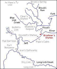
Their pilot guided them south along an old buffalo path from the Falls almost to Bullitt's Lick. Bullitt's Lick was the hub of a great system of buffalo roads leading into it from all directions like the spokes of a wheel. Once they had passed through the Blue Lick Gap in the Knobs, though, they turned eastward away from Bullitt's Lick, falling into another buffalo path that led up Salt River on the north side. There, just below the mouth of Floyd's Fork where the buffalo path forded it, and between a quarter-and-a-half mile from the bank of Salt River itself, they selected a site and commenced building a fort.
The date is important. Early spring—March or April—1779. 10
1777 had been the year of the bloody sevens when the settlements in Kentucky had shrunk to but three—Harrodsburg, Boonesboro, and Logan's. 11 The next spring, 1778, Clark had arrived at the Falls and a fort had been planted on Corn Island. During the fall of 1778, the settlers had built a fort on shore where they had spent the winter. 12 Then as soon as winter had broken, the party of 18 men had left to build Brashear's at the mouth of Floyd's Fork. The first station on the Wilderness Road between Harrodsburg and the Falls—antedating Bardstown, Cox's Station 13 and probably any of the stations that sprang up the same year on Beargrass Creek here in Jefferson County. 14
Colonel Fleming, on his way from Harrodsburg to the Falls of Ohio in 1779, stopped at Brashear's Garrison, where he got some excellent "taffieo" drink—whatever that was. 15 He mentions no other stations on the road in all that vast stretch of wilderness and he was a remarkably astute observer.
Richard Collins in his history of Kentucky not only lists Brashear's Station but a "Salt River Garrison" as well on the lower waters of Salt River. 16 So does Willard Rouse Jillson in his Pioneer Kentucky, following Collins, I suppose. 17 Everywhere they are treated as two separate and distinct stations. As a result, I sought in vain for the location of Salt River Garrison. Then suddenly the mystery of Salt River Garrison was resolved by an old plat.
Brashear's Station and Salt River Garrison were one and the same. 18
Confirmation followed thick and fast among the records at Shepherdsville, until there could no longer be the slightest doubt. To add further to the confusion, Brashear's Station had been called "Froman's" by some of the settlers as well as 'Salt River Garrison." 19
Brashear's, Salt River Garrison, or Froman's Station—it was referred to by all three names—is not to be confused with the Froman's Station in Nelson County, nor yet with Froman's Folly at Irons' Crossing on Salt River below the mouth of Bullitt's Lick Run.
For after helping to build Brashear's Station, Jacob Froman remained there only a couple of years. Then in 1781 he removed to a branch of Cox's Creek in Nelson County and built another fort not far from Roger's Station. 20
As for "Froman's Folly," there is but the briefest, tantalizing glimpse—its very existence only hinted at in a scrawled line in one of the old yellowed depositions. 21
BULLITT'S LICK
About the time that Brashear's Station was being built, three men left the Falls to go hunting—Squire Boone, brother of the redoubtable Daniel, William Moore, and James Lee. They had horses and traveled along the buffalo road, heading for Bullitt's Lick.
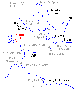
Squire knew the road for he had been this way before—as early as 1776, he deposes. When they reached the lick, they killed a couple of buffalo, skinned and butchered them and loading their horses with meat, returned the way they had come. 22
Consequently, no saltworks could have been erected at Bullitt's Lick by the spring of 1779. This seems fairly certain; for the big game invariably was driven away whenever a lick was "opened" for salt making.
However, in November of the same year, Colonel William Fleming, at the head of the land commission, was journeying from Harrodsburg to the Falls. After leaving Brashear's Station, he went through the Salt River flats to Bullitt's Lick, where he found a full scale saltworks in operation. 23
Therefore, it would appear that the saltworks must have been erected some time between Squire Boone's visit and Colonel William Fleming's arrival. Probably in the summer of 1779.
Fleming writes in his journal:
"Nov. 13, 1779—Bullitt's Creek as it is cald is perhaps the best Salt Springs in the country ... They have a trough that holds very near 1000 gals. which they empty thrice in the 24 hours. They have 25 kettles belonging to the commonwealth which they keep constantly boiling and filling them up as the water waistes—from the trough first into kettles which they call fresh water kettles and then into others. After this management for 24 hours they put the brine into a cooler and let it stand till cold or near it and draw off the clear brine into the last boilers under which they keep a brisk fire till they observe it begin to grain when they slacken the fire and keep them at a simmering boil till it grains. They then put it to drain. When drained they think it fit for use ... 3000 gals. of water boiled down yields from three to 4 and 4 1/2 bushels. The dryer the weather, the better for making salt. These remarks I had from Chenith the manager." 24
Colonel Fleming spent the night at the Saltworks and the next day he left for the settlement at the Falls, traveling along the buffalo path that was rapidly becoming one of the main traveled arteries in the wilderness. 25
On 25 December 1779, just a little over a month later, another significant entry appears in Fleming's journal:
"We heard by a man from the Falls, the Indians had killed a man and a boy and taken two boys prisoners at the mouth of Floyd's Cr. near Brashear's Station and that the people had left the salt works and taken their kettles away, leaving the pots or kettles belonging to the publick." 26
MUD GARRISON
Indians or no Indians, the Saltworks did not long remain idle. During the spring of 1780 the tide of emigration was running strong. The demand for salt grew greater and greater as new stations were erected. It rose in price to five hundred dollars a bushel, then to seven hundred dollars, in the depreciated currency. 27
Sometime during that spring, the saltmakers came back; the wells were cleaned out; fires started anew in the furnace pits. 28 This time, however, they made preparations to protect their families at least against Indian depredations.
On the bank of Salt River not far from the lick, they built a fort—a double row of piles filled with earth and gravel from the river bank and enclosing about half an acre. 29
Mud Garrison, as it came to be called, was first settled about the last of March or the first of April 1780. 30 Not 1778, as Collins has it. 31 Nor was it located anywhere within the future environs of Shepherdsville, as Mr. Willard Rouse Jillson states. 32
It was situated on the north bank of Salt River about a half mile above the mouth of Bullitt's Lick Run which put it very close to the Saltworks and at least a mile down river from the future site of Shepherdsville. For the accuracy of this, we have the words of old John Burks, the hunter; of Worden Pope, and a number of others—men who actually lived at the Mud Garrison or at one of the neighboring stations. 33
Michael Teets and his wife, James Hamilton, and the Millers were among the company who built it. 34
The garrison did not have an enviable reputation as the following passage from a deposition of James Daugherty bears witness:
"Q. Were the persons that first settled the Garrison men of respectability?
"A. Mr. Teets, James Hamilton, and Mrs. Teets were people that might be relied on." 35
Which was as far as Mr. Daugherty could be persuaded to commit himself.
They were a rough, hardy lot—these early, brawling saltmakers, the frontier levelers. The Saltworks, itself, was known as a "fair hell on earth." 36 General James Wilkinson describes them as a set of "sharpers," a classic example of the pot calling the kettle black. 37
DOWDALL'S STATION
The third station to be established in the neighborhood was Dowdall's Garrison. Who founded the new station and when are still largely matters of conjecture. However, it was probably erected early in 1780 by settlers who found their quarters at Brashear's Station becoming cramped. 38
Thomas and James Dowdall were among the first settlers at Brashear's Station. So were the McGees, but they all removed to Dowdall's, as well as a number of other families.
Whatever the cause, Dowdall's Station was built on the north side of Salt River about a mile below Brashear's Garrison. It was on a tract of land surveyed and patented in the name of Jacob Myers and known as Myers' 400-acre survey. 39
The falls or rapids of Salt River begin at present-day Shepherdsville and extend a mile or more downstream, while above the falls lies a deep pool. Dowdall's had been erected on the upper bank of the river at this pool. It was an excellent site for a ferry and indeed, not long after the station was built, a ferry was established there—the first ferry across Salt River.
This ferry was to have considerable effect on the old Wilderness Road. Formerly, travelers going from the Falls to Harrodsburg after leaving Bullitt's Lick had journeyed up the north side of Salt River, fording the river about a mile below the mouth of Cox's Creek. 40 Now they could ferry across at Dowdall's and take another buffalo path that went up the south side of Salt River, ford Cox's Creek at the mouth of Rocky Run, and go up the east fork of Cox's Creek to Harrodsburg. 41 This route rapidly gained in importance.
The exact date when the ferry was first established and by whom is still pretty much a mystery. However, on the 25th of June, 1781, George Grundy leased from Jacob Myers the 400 acres including Dowdall's Garrison and the ferry. Grundy had to agree that he would respect any former indulgences that may have been given by Jacob Myers to the settlers at Dowdall's Station. But the important fact about the lease is that it reveals the ferry was in operation as early as June 1781. 42
No description of the Salt River Ferry would be complete without some mention of Ben Pope and the McGees.
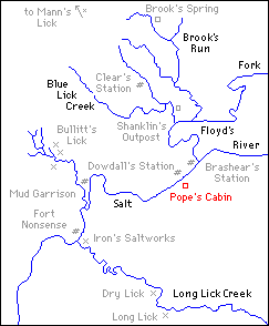
Benjamin and William Pope were brothers, who with their families had settled at the Falls of Ohio in 1779. They were shrewd, capable men, engaging in a great many pursuits—land speculation, the infant salt industry, politics, and trade—and any history of this region must take them into account.
Benjamin Pope removed with his family to Brashear's Station in 1783 where he lived a few months, then moved again, this time to Dowdall's. 43
The McGees had arrived at the Falls about the same time as the Popes but they had gone straight inland to Brashear's Station. 44 Patrick McGee was a hunter, a land locator, and a saltmaker. The land across Salt River from Dowdall's had been entered by John Edwards, an early land speculator; it was first-rate land and Patrick McGee bought out Edwards' claim. 45
Then in 1784, he and Ben Pope built a cabin or cabins on this tract on the south side of Salt River opposite Dowdall's Station and moved out of the protection of the garrison. 46 In 1787, Ben Pope traded some of his land on the Beech Fork to McGee for the ferry tract, as it had come to be called. 47 The Popes have owned and lived on this same tract ever since. Miss Sallie B. Pope lives there today, in the house of which the nucleus is the original hewn log cabin, built by Ben Pope and Patrick McGee.
The cabin, weatherboarded and plastered, occupies the northwest corner of the present building. It has been converted into a charming and spacious sitting room and hall. Only the thick walls hint at the time when it stood alone as a protection against Indian attack for travelers about to take the ferry across to Dowdall's. For in 1784 Patrick McGee had his house licensed as a tavern, 48 and the Popes operated the ferry there for many years. 49
CLEAR'S STATION
I haven't been able to find out very much about the next station to be established—Clear's Station or Clear's Cabins, 50 as it was sometimes called.
Collins mentions it as being in Bullitt County. 51 He is right as far as he goes, but Bullitt County covers considerable territory. Some facts about it, however, have turned up in unexpected places.
Clear's Station was erected by George Clear well before 1783 and perhaps as early as 1780 or '81. 52 It was on Clear's Run, just a short distance above the crossing of the old Wilderness Trail from Louisville to Bullitt's Lick, and in the neighborhood of present-day Huber's Station on the L. & N. railroad. 53
George Clear was unfortunate in picking his site; for Isaac Hite, Robert Shanklin, David Williams, Peter Casey, Ebenezer Severns, and Peter Higgins had traveled through this part of the county in company in the spring of 1776 54 and Shanklin had made an entry on the Blue Lick Run, of which Clear's Run is a branch. The conflicting claims were taken to court and Shanklin's was adjudged the better in so far as their lands interfered. Clear only recovered 258 acres out of his original 1,400 acre settlement and pre-emption. 55
Long before the case was settled, though, George Clear had employed Walker Daniel to defend his suit and had betaken himself off to the Ohio country. 56 But Clear's Cabins continued to be inhabited by settlers migrating to Kentucky. Isaac Hornbeck and his family moved to Clear's Station in 1783. 57 In 1784 the Shanklins came with their party, which included Mrs. Sodowsky and James Alexander. 58
The road from the Saltworks at Bullitt's Lick to the Falls of Ohio ran a few hundred yards east of Clear's Cabins which nestled at the foot of the Lost Knob. 59 Colonel John Floyd in his scarlet cloak was ambushed by Indians almost within shouting distance of the station. 60 The colonel was mortally wounded. His brother, Charles, whose horse had been shot out from under him, leaped up behind the colonel and escaped, holding up his wounded brother in the saddle. 61
What happened to Colonel Floyd after his brother had galloped off with him from the scene of the ambush has been for a long time the subject of considerable dispute.
A persistent rumor has survived that Charles carried his dying brother to the Saltworks at Bullitt's Lick which was only some three miles distant. There, the rumor goes, the colonel expired in one of the saltmaker's cabins and was buried at Bullitt's Lick.
Mr. Hamilton Tapp, however, in an article on Colonel John Floyd, denies emphatically that the wounded man was taken anywhere near Bullitt's Lick, let alone buried there. He goes on to make the statement that not shred of evidence exists in support of the rumor. 62
However, it's a dangerous thing to deny categorically so persistent a tradition.
As it happened, the observant Colonel Fleming was in Kentucky again and at Logan's Station when he received news of Floyd's death. On 7 April 1783, he made the following note in his journal:
"...Gen'l Clark and Mr. Daniels came up and informed us that Col. Floyds; One of his Brothers and another person going to the Saltworks were fired on by Indians. Col. Floyd mortally wounded, his Brother's horse shot under him, and the third person shot dead, that Col. Floyds with his Brothers assistance got to the salt works." 63
Col. Fleming, of course, could have been misinformed.
Mr. Tapp states that Charles, bearing his mortally wounded brother, fled back the road the way they had come until they reached the cabin of a friend about five miles distant. There they stopped. Colonel Floyd died in the friend's cabin and his body subsequently was carried home to his station on Beargrass. 64
Mr. Tapp doesn't identify the friend; however, in all fairness, Colonel James Francis Moore might have been settled at the Fishpools about five miles back the road as early as 1783. If he was, his was the only house on the road between Clear's Cabins and Sullivan's Old Station on the south fork of Beargrass.
Whether Colonel John Floyd was carried back to Colonel Moore's house at the Fishpools or ahead to Clear's Station or even to Bullitt's Lick isn't important in itself. Wherever he died, his body unquestionably was borne back to his station on Beargrass and there he was buried.
What does seem important is this invidious tendency to treat Bullitt's Lick like the skeleton in Kentucky's closet, to put it in historical coventry. Colonel Floyd can't even be allowed to die there in peace. I can't help but wonder why.
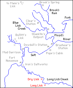
LONG LICK
The second saltworks to be erected in the neighborhood was at the Long Lick.
Long Lick Creek is a branch of Salt River. Its mouth is on the south side only a short distance below Bullitt's Lick Run. The Long Lick, itself, is about five or six miles in a general southeasterly direction from Bullitt's. Bardstown Junction lies just east of the site today and state highway 61 crosses Long Lick Creek almost at the lick. 65
Parmenas Briscoe, a hunter at Brashear's Garrison, recognized its importance early and on November 11, 1780, he located an entry of four hundred acres in which he was careful to include the lick. 66
Salt licks were eagerly sought out by the first settlers and land locators and the Long Lick was no exception. Besides Briscoe's pre-emption, Peter Phillips had a settlement and pre-emption right to 1,400 acres. Charles Chinn entered 1,000 acres on the Long Lick; Henry Spillman and John Cocky or "Cockeye" Owings entered 400 acres; John Bowman entered a thousand; John May and Mark Oyler entered 400; Benjamin Frye a thousand; Jacob Myer, 400, and John Friggs, 200. 67
Most of these claims overlapped to a greater or lesser extent. It was confusion compounded. The wrangling in court was dragged out for 50 years.
However, the most important of the claims to the Long Lick was none of these, but a 250-acre warrant, which Charles Broughton had entered November 11, 1780, the same day that Briscoe had made his entry. The two entries covered almost the same ground. Nevertheless Charles Broughton went ahead and erected a saltworks on the land some time before the 27th of October 1785, when he had his entry surveyed. It was the first saltworks on Long Lick Creek. 68
In 1784, Nelson County had been formed out of Jefferson. Salt River was the dividing line and the Long Lick fell in the new county. 69 Shortly after the saltworks was erected, Henry Crist and Solomon Spears acquired Briscoe's claim.
Whether Briscoe's claim was superior or not is still uncertain. In any event, Crist and Spears took over Broughton's saltworks as early as 1787 and the next year a patent for the land was issued on Briscoe's survey in their names. 70
Henry Crist was a remarkable young man. He cannot be treated adequately in a paper of this scope. Tradition describes him as a small man, almost tiny in stature, but with an unquenchable drive, vigorous, colorful, autocratic, and contentious. Lawsuits were his ruin. At one time he had laid claim to thousands of acres; when he died, he was practically penniless. 71
He rose to the rank of General during the War of 1812 but his abiding interest was business. His life was bound up with land speculation, trading, and the salt industry generally—first at the Long Lick, then later at Bullitt's.
Henry Crist was from Pennsylvania. He was only fifteen years old when he arrived at the Falls of Ohio in 1780. 72 While still in his teens, he was acting as a land locator for another Pennsylvanian by the name of Jacob Myers. 73 Jacob Myers at one time probably claimed more land in Kentucky than any person before or since. A great many of Jacob Myers' claims lay in present-day Bullitt County—claims which Henry Crist helped to locate and for which Crist received a moiety of one half the land for his services.
He could not have been much over twenty when he and Solomon Spears bought out Briscoe's entry at the Long Lick. He was only 23 when the famous Battle of the Kettles took place on Salt River in 1788.
There is a vivid account of the battle in Collins' History and I won't repeat it here but Solomon Spears was killed and Crist seriously wounded. 74
Close to the Long Lick proper and a little further down the creek from it was a second lick known as the Dry Lick. Charles Broughton had another entry for 500 acres which joined his 250 acres on the Long Lick. The 500-acre tract included the Dry Lick, and this he had managed to hang on to. When he lost out at the Long Lick he began to prospect for salt water on his Dry Lick property.
Luck was with him. He found an excellent vein of salt water, sunk a well and soon was back in the salt-making business. Broughton never gave up the Dry Lick. He and his heirs, the Shains, continued to make salt there through all the ups and downs of the trade. 75
The Long Lick and the Dry Lick were about a mile apart. Though separate and distinct operations, they were so closely associated that any account of one is incomplete without some mention of the other. Both of them had a long and colorful history and the names of some of the oldest families in Bullitt County are coupled with the salt trade there—Henry Crist, Adam Shepherd, Thomas Shain, James Bowman, Thomas Speed, Joshua Frye, Nacy Brashear, to mention only a few.
MANN'S LICK
The third lick to be opened was Mann's Lick. Third in point of time, perhaps, but second only to Bullitt's Lick itself in importance! Mann's Lick lay to the north of Bullitt's Lick in amongst the ponds and wetwoods near the site of present-day Fairdale in Jefferson County. 76
There has been, perhaps, more confusion regarding the date when salt was first made at Mann's Lick than at any of the other licks. One author, in an excess of zeal, puts it back as early as 1780. 77 Fortunately the record is clear and irrefutable.
Mann's Lick was well known to the earliest settlers at the Falls. In 1780, John Todd made an entry on a military warrant for 200 acres, including Mann's Lick. James Speed entered 600 acres adjoining Todd's entry the same year. Overlapping entries followed thick and fast. George James and Daniel Sullivan, Bracket Owens, William Garrard, James Francis Moore, Levin Powell, George Slaughter, James McCawley, John Hamilton—all of them made entries there. 78
Nevertheless, no settlement was attempted; the land remained drowned in ponds and swamps, a hunting ground only, until Joseph Brooks entered the scene in 1787. 79
Joseph Brooks was a Pennsylvanian also. At the age of twenty-five he emigrated to Kentucky with his family, arriving at the Falls in the spring of 1780. He lived at Spring Station on the Beargrass until February 1781, when he moved to the Saltworks at Bullitt's Lick, where he remained until 1784.
In 1784, he bought a land entry at Phillips' Spring on the road between the Falls and the Saltworks. There he built a cabin and took his family to live. 80
Phillips' or Stewart's Spring, as it was alternately called, was a famous camping place on the road. 81 In 1785, Brooks obtained a license and began to operate a tavern in his house. 82 Gradually it took the name of Brooks' Spring and is known so to this day. It is still visible on the Blue Lick Pike a short distance south of the Bullitt County line. 83
Joseph Brooks was a shrewd, capable man. Moreover, he had lived and worked at the Saltworks at Bullitt's Lick for three years. He was quick to see the possibilities of Mann's Lick.
John Todd was dead, 84 the land was in contention, 85 but in the fall of 1787, Joseph Brooks approached Todd's widow and secured her agreement to let him have the lick for a term of six years. The first two years he was to have it rent-free for erecting a saltworks there. Thereafter, he was to pay her only 100 bushels of salt per year. Brooks had a bargain, and he knew it. 86
Unfortunately the widow Todd did not have an undisputed title. William Fleming owned a quarter interest and James Speed claimed a quarter interest in addition to his own adjoining entry. In 1788, Speed rented the lick to George Wilson, who put up a saltworks close to Brooks' furnaces. 87 There was room for both, however, and they seemed to have gotten along amicably enough.
Eventually more wells were sunk, more furnaces built. Wilson bought out Fleming and became one of the proprietors. Brooks acquired part of the land outright also. The Speeds, Charles Beeler, Colonel James Francis Moore and William Pope all were operating saltworks at Mann's Lick or engaged in the salt trade. There was an island in the Big Pond. Wells were sunk on it and more furnaces built. 88
To Joseph Brooks, however, must go the honor of being the man who first opened Mann's Lick.
Unlike Bullitt's Lick, Mann's Lick was fortified to some extent. 89 In 1788 when Brooks moved there, the danger from savages was acute. Moreover, it occupied a peculiarly exposed situation with the knobs on one hand and the swampy wetwoods on the other. In the bitter winter months, wolves came right into the lick and pulled down the stock.
Nevertheless, a new day was at hand. From Mann's Lick on the north to Long Lick on the south, the forest was falling before the wood choppers. The furnaces devoured wood at a fearsome rate. The sound of ax strokes filled the air.
EXTENT OF SALT TRADE
The contrast between this salt-producing region that straddled Salt River and the rest of Kentucky at this early date was so great that it is hard to make it comprehensible.
Salt was beginning to be produced at a few other places throughout the state, but nowhere else was there such a concentration of wells and furnaces. Hundreds of men were employed in the actual industry as wood choppers and waggoners, kettle tenders, and water drawers. Many more, such as hunters and store keepers, coopers, and carpenters, were directly involved. People came from all over the wilderness to procure the precious salt—merchants, traders, private individuals in companies for protection against savages.
Salt was sent by pack train and flatboat and pirogue to the District Mero in Tennessee, to the Illinois, to Kaskaskia, from one end of the wilderness to the other. Bullitt's Lick must have taken on something of the nature of a boom town—a startling, unbelievable sight to the hunters in from the deep woods, to the settlers from their lonely clearings.
Louisville was a sickly place, due to ponds and swamps, and was growing painfully slowly. Lexington was only a small stockade. Frankfort had not yet been established.
Money was scarce but trade was carried on by means of barter and notes. The complications and obstacles were enormous and confusing.
It has been difficult enough to try to unravel the bewildering system of exchange. But the actual process of salt making was worse. It was an utter mystery.
It is very easy to say that the salt water was evaporated in kettles. This is so general that it is meaningless.
Let me quote from a letter written by one Thomas Perkins from Lincoln County, February 27, 1785. He is writing to the Honorable J. Palmer in Braintree, Massachusetts:
"Honored Sir: It is not from inattention or forgetfulness that I have suffered your inquiries concerning the salt springs of the country to remain thus long unanswered; but from a hope that by this time I might be able to give you some satisfactory account of them. I must, however, confess that notwithstanding all the information I am able to get I am still as ignorant of the matter as I was the moment I came into the country.
"The owners of these springs reside commonly in the old part of Virginia or Maryland and carry on the business of salt-making by negroes and ignorant people under the direction of an overseer as ignorant as themselves; so that it is impossible to learn anything from them worth hearing.
"I have seen but one spring of consequences in this district which is at a place called Bullitt's Lick on a small branch of Salt River ... At this spring, by the best information I could get, about 40 gallons of water will produce a bushel of salt. At the distance of a quarter of a mile from the spring is a small mountain ... from the bottom of which the salt water appears evidently to proceed; and they now dig wells between the spring and the mountain 30 or 35 feet deep, and that the nearer they approach the mountain, the stronger the water is impregnated with salt.
"It is remarkable that the water from which they boil the salt is almost as black as ink, owing, as it is supposed, to its passing through a ... pit of coal; and this idea is strengthened by the smell of the water when boiling, resembling that of the burning of coal, with a very strong mixture of sulphur. This blackness, however, disappears before the water is half boiled away; and the salt appears perfectly clean and white and is made with so much ease, notwithstanding they labor under every inconvenience, from the want of proper pans, etc., that they can well afford to sell it at $3.00 per bushel ..." 90
So much for Thomas Perkins. He was on the ground while the saltworks was still a going concern. I wasn't so fortunate.
Actually, as near as I have been able to determine, 91 the furnaces were long trenches dug back along the top of a bank. They were walled with slate about 15 inches thick which was laid with a mortar of clay. The kettles themselves held about 22 gallons each—sometimes they were bigger—and they sat on top of this trench in a row, with as many as fifty in the string. The furnace was fired from in front, the flames and smoke being sucked along under the kettles and out through a stone chimney at the far end of the pit. Generally they were protected from the elements by a shed roof supported on poles. It was quite common for two of these long narrow furnace pits to be under a single roof.
The water was boiled for about twenty-four hours, then transferred to a cooler—a trough, which acted as sort of a settling tank, I presume. Then the clear, saturated brine was drawn off into the kettles again, and boiled rapidly until it began to grain. Sometimes blood was added to purify the water, or the white of an egg.
When it began to grain, or form salt crystals, the fires were slackened but not so much as to stop it boiling and the salt was dipped out by hand as it formed, and put in baskets to drain.
The drippings were caught in pans, and returned to the "mother" as the water in the kettles was called. These kettles holding the mother were never allowed to boil dry. When the mother got too low, water which had been previously boiled twenty-four hours was let into them and the boiling down repeated.
However, after a certain number of boilings, the mother became so charged with impurities that it was necessary to throw it out and the whole process started over again.
The first wells were dug wells and shored with timber instead of stone. Later they were deepened by boring in them with an auger. Sometimes dikes were thrown up around them to keep out flood water and usually roofs were built over them.
The furnaces or pits were erected at some distance from the well, close to a good stand of timber, for it wasn't considered profitable to haul wood much more than a mile. It was easier to move the furnace to a new stand of trees.
If the furnace was situated close enough to the well, the water was brought to the pit by means of a covered wooden trough or flume. As wood grew scarce about the licks, the furnaces were moved further and further off. The water was conveyed to them through wooden pipes made from gum or sassafras logs. These wooden pipes were bored out by hand, fitted together, and a wooden or iron sleeve fashioned around the joints. Then a trench was dug and they were buried beneath the frost line. Some of these strings of pipes went for miles.
One string went from Bullitt's Lick all the way to Shepherdsville, crossed Salt River and ended at the furnace a half mile south of the river. Another left Bullitt's Lick following the general course of the Pitt's Point road to a furnace located well within the present boundary of the Fort Knox reservation.
These are only two examples. The pipe lines sprangled out in all directions. Miles of the old pipes must still be preserved in the ground about Bullitt's Lick and Mann's Lick, the Long Lick, and the Dry Lick.
The hungry furnaces brought about another paradox in the neighborhood. In most parts of the state, cleared land was at a premium. Sometimes a man would be given half of the land he cleared in payment for the laborious job of clearing it.
In the neighborhood of the saltworks, however, timbered land was ten times as valuable as cut-over ground. The competition for firewood grew more and more bitter all the time, until it got to be as much as a man's life was worth, if he was a landowner, to try to protect his own timber from the ravages of the saltmakers.
Poor Benjamin Stansberry, who owned 500 acres close to Bullitt's Lick, testified that the saltmakers had broken his arm when he had tried to stop them from cutting and carrying off his wood. Moreover, they added insult to injury, reviling and abusing him whenever he was forced to go into the lick on business. 92
FORT NONSENSE
Earlier, I mentioned that a great buffalo road forded Salt River below the mouth of Bullitt's Lick Run. It led from Bullitt's Lick to Long Lick and soon became a favorite crossing for travelers going between the two licks because it was considered less dangerous during times of Indian trouble than the ford up river at the future site of Shepherdsville. 93 Sometime in 1785 or possibly earlier, a station was erected on the north side of Salt River not far from the buffalo ford. For some reason it was called Fort Nonsense. 94
It was located within the bounds of Jacob Froman's 1,670-acre survey [ link to survey ] that joined Christian's "Bullitt's Lick Tract" on the lower side. And in one deposition it is referred to as "Froman's Folly."
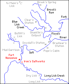
William Farmer had a 700-acre claim on Salt River that lay wholly within Jacob Froman's entry and took in the site of Fort Nonsense also. Farmer's claim was superior and Jacob Froman lost that part of his land where Fort Nonsense was located. 95
It is possible that the Fromans built Fort Nonsense on what they thought was their land only to be dispossessed by William Farmer—hence the name "Froman's Folly" or Fort Nonsense.
However, this is merely conjecture. Practically nothing is known about Fort Nonsense. Collins mentions it but gives neither the date it was established nor the location. 96
Fortunately, salt water was discovered in the bank of the river at the buffalo ford across from Fort Nonsense or I might never had found its site.
Jonathan Irons, a salt maker at Bullitt's Lick, purchased that part of Farmer's entry which included Fort Nonsense. He acquired some land on the opposite side of the river from the old fort and commenced prospecting for salt water. In 1798, he found it almost in the bed of the river just a few steps from the buffalo ford. One of his wells was actually half in the river bed. 97
Thus Irons' Lick was the next to be opened for salt making and was situated on the south side of the river across from Fort Nonsense. Irons moved to the site of the fort and there took up his residence. 98
Jonathan Irons was a colorful character; illiterate, too generous for his own good, given to long drinking sprees which eventually killed him. 99
The buffalo crossing gradually became known as Irons' Crossing, and Fort Nonsense as Irons' saltworks. In time even these names were no longer used until finally the fact that there had been a famous saltworks on the river bank was entirely forgotten.
THE SALTMAKERS
Colonel William Christian, the proprietor of Bullitt's Lick, did not come to Kentucky until 1785, and then he was promptly killed by Indians the following year. 100 In his will, he left "Saltsburg," as Bullitt's Lick had come to be called, to his son, John Henry Christian. 101 The colonel's passing made very little difference to the saltmakers.
An agent had handled Christian's interests at Bullitt's Lick before he emigrated, leasing the saltworks to various operators. John H. Christian was under age; Anne Christian, his mother, was appointed his guardian and by her direction an agent still handled affairs at Bullitt's Lick. 102
Moses Moore leased the whole lick, subletting to half a dozen or more men who operated furnaces independently. 103 This was the general procedure at all the licks in the neighborhood. There were a score of independent operators at Bullitt's and Mann's Licks, not so many at the Long Lick and only one or two at the Dry Lick. Even Jonathan Irons was soon leasing out his new saltworks at Irons' Lick. 104
John Christian's mother, however, died before he came of age and Patrick Henry was appointed the boy's guardian. The procedure, however, didn't change materially. Walter Warfield was Henry's agent. The independent operators banded together and tried to rent the lick themselves from Warfield, but Moses Moore went to Virginia and secured a lease directly from Patrick Henry. The case was taken to court, but Moses seems to have won out in the end. 105
Then John Henry Christian died shortly after coming of age, leaving his sisters as heirs to the saltworks at Bullitt's Lick. The fat was in the fire, at last.
There were five sisters and each of them had a fifth share in the property. Alexander Scott Bullitt had married one sister and John Pope had married another. The Popes acquired some of the interest of the remaining sisters, so that in the end William Pope, Jr., brother of John Pope, controlled three-fifths of Bullitt's Lick and the Bullitts the remaining two-fifths. The Bullitt's Lick-Mann's Lick Company was formed and an attempt made to regulate the salt trade. 'Deposits" were built to store the salt—one at Shepherdsville to accommodate the output of Bullitt's Lick, and one near South Park for Mann's Lick. 106 Old Deposit Station on the L. & N. Railroad was not a pioneer settlement but a warehouse in which to store salt. 107
This wasn't the first time that an effort had been made to gain a monopoly in the pioneer salt industry.
General James Wilkinson, according to Dr. Thomas Clark, very nearly succeeded shortly after he came to this state. 108 And in 1792 four men—Thomas Smith, Moses Moore, Phillip Buckner, and Jonathan Owsley, under the name of Moses Moore and Company—leased the Long Lick from Adam Shepherd and Henry Crist. They already controlled Mann's Lick and Bullitt's Lick and they let the Long Lick lay idle in an effort to force up the price of salt. 109
How successful they were I do not know.
In any event, the Bullitt's Lick-Mann's Lick Company, some ten years later, did very much the same thing. They notified the independent operators that once their current leases had expired, they would not be renewed.
Thus, during the part of the year 1802, Bullitt's Lick lay idle. The first time such a thing had happened since 1779 when the Indians had caused the saltmakers to abandon their works.
Salt shot from a dollar to three dollars a bushel and it wasn't to be had then except for cash. 110
PARAKEET LICK
Always a certain amount of prospecting for salt water went on in the neighborhood. The town of Shepherdsville had been established in 1793. 111 Then Bullitt County was formed in 1796 out of parts of Jefferson and Nelson, and Shepherdsville was made the county seat. 112 About a half mile above Shepherdsville was a pretty little lick on the north bank of Salt River known variously as McGee's Lick or the Parakeet Lick from the flocks of these colorful birds that frequented the place. Here James Burks discovered salt water and secured a lease from the McGees, who owned the tract of land it was on.
Burks was to have the lick for two years rent-free for opening it. However, he didn't have the necessary cash for the kettles.
The salt water was never too plentiful at Parakeet Lick nor was it of a very high order. It is doubtful that the lick would have been opened had it not been for the machinations of the Bullitt's Lick-Mann's Lick Company.
The scarcity of salt in 1802 and 1803, though, guaranteed the success of the venture. John Dunn, who had plenty of kettles, formed a partnership with James Burks and in 1803 they commenced making salt at the Parakeet Lick. 113
The McGees, James Alexander, and John McDowell all subsequently made salt at Parakeet Lick. 114 It was abandoned, though, not too long after Bullitt's Lick started up again. Its later fame as a watering place completely eclipsed its earlier, rougher history. For this was the famous Paroquettte Springs, one of the most fashionable spas of the old south. The sulphur well was, in reality, one of the old salt wells. Its metamorphosis must have come as a shock, indeed, to the old settlers who could remember it in its ruder days. 115
For a while in the first years of the nineteenth century, the saltworks at Bullitt's Lick flourished like the green bay tree. It was also the heyday of the flatboatman, and an extensive salt pork and whisky trade was carried on with New Orleans. But the coming of the steamboat was to bring an end to both the saltworks and flatboating.
Salt finally could be imported cheaper than it could be made by the crude processes in use at the licks. Better methods of extracting salt were being discovered and richer veins of salt water.
When Henry Crist bought out the Bullitt interest in the lick in 1814, 116 it was still flourishing but its years were numbered. Eventually Crist acquired the whole lick, but by that time, salt making was barely profitable. 117
The saltmakers managed to hang on grimly for a while in spite of everything. But the odds against them had mounted until finally they were operating at a loss. In 1830 the fires were allowed to go out under the last kettle. 118 Cahaz Knob finally looked down on peaceful farm land.
It is difficult to realize how completely time and nature have obliterated nearly all evidences of the saltworks at Bullitt's Old Lick. Several years ago Ben Miller, who owns the site today, was plowing up a cornfield and uncovered the chimney remains of a few of Saltsburg's cabins. The ash banks from the furnaces have given the earth a grayish cast in places. A few metal shards can be picked up about the pits. The wells have been filled up. Even Crist's big black well is only a saucer-shaped depression.
This is sort of a plea, I suppose. A plea for Bullitt's Lick and the surrounding area to be accorded recognition—to be given its proper niche in history. A plea for markers to be placed at these sites before it is too late.
We mark battlefields, but this was more than a battle. This was an epoch in the conquest of the wilderness.
FOOTNOTES
1 John Bakeless, Daniel Boone, Master of the Wilderness (New York, 1939), p. 156ff.; Thos. D. Clark, "Salt, A Factor in the Settlement of Kentucky;" Filson Club History Quarterly, XII (1938), p. 43; Geo. W. Ranck, Boonesborough, The Filson Club Publications No. 16 (Louisville, 1901), p. 64.
2 John Filson, Kentucke, and the Adventures of Col. Daniel Boone, facsimile reproduction, ed. by Willard Rouse Jillson (Louisville, 1934), pp. 32-3, original published Wilmington, 1784. Filson writes, "At present there is but one, Bullitt's Lick, improved, and this affords salt sufficient for all Kentucke, and exports some to the Illinois."
Jos. Brooks Heirs vs. Geo. Reed et. al., Bullitt Circuit Ct., Decrees No.76. Depositions of Chas. Whitaker, 23 Aug. 1811; Wm. Pope, Sr., 22 Aug. 1811; Jacob Vanmeter, 23 Aug. 1811; John Tuell, 23 Aug. 1811; all say that the saltworks at Bullitt's Lick supplied the whole country with salt from about 1779 through 1783.
Sanders & Rogers vs. Benjamin Summers et. al., Bullitt Circuit Ct., Decrees No.101. Bill, filed 18 Aug. 1812, states that on the 3rd. Feb. 1783, there was no place in the present state of Kentucky where salt was made except at Bullitt's Lick. Depositions of James McCawley, 1 Mar. 1814; Benjamin Stansberry,. 1 Mar. 1814; Jos. Brooks, 1 Mar. 1814; James Patton, 25 June 1814, James Guthrie, 25 June 1814, repeat in substance the above statement. However, James Welch, 2 Mar. 1814, says that he understood from information that salt was made at the Blue Licks about that time (3 Feb. 1783). Welch's information was not far wrong but is misleading. Cf. footnote 9 for salt making at the Blue Licks.
Equity suits tried at the Bullitt Circuit Ct. are filed in numbered bundles labeled "Decrees."
3 Lewis & Richard H. Collins, History of Kentucky (Covington, 1882), II, 17-18; H. Marshall, The Hislory of Kentucky (Frankfort, 1824), I, 31.
4 State Land Office: Frankfort, Ky.
5 Cary Robertson, "Salt and the Part It Has Played at Shepherdsville," Louisville Courier-Journal, Nov. 7, 1926, quotes Dr. C. G. Crist as saying that the saltworks started 1778. Hewitt Taylor, "Shepherdsville," Louisville Herald Post, Sept. 23, 1936, puts the first settlement back as early as 1775. Collins, op. cit., II, 18, quotes a deposition by Bland Ballard who says that salt was made at Bullitt's Lick in 1780-81. By far the majority of authors, however, hazard no opinion beyond saying that salt was made at Bullitt's Lick at a very early date.
6 A bibliography of works on the Wilderness Road would form a respectable volume, but in almost every case only the eastern leg from Virginia to Harrodsburg is treated with any thoroughness. Filson's Kentucke, on his map of 1784, shows it continuing on from Harrodsburgh through Bullitt's Lick to Louisville, but information about this end of it in the works of later historians is conspicuous by its absence. Thos. Speed, The Wilderness Road, Filson Club Publications No.2 (Louisville, 1886) and Wm. Allen Pusey, The Wilderness Road to Kentucky (New York, 1921) are both excellent books, but deal primarily with the eastern leg, and the route from Harrodsburgh to Louisville is located in only the most general way. Even so fine a work as Robert L. Kincaid, The Wilderness Road (Indianapolis, 1947), does little to dispel the mystery surrounding this end of it.
7 Thomas D. Clark, A History of Kentucky (New York, 1937), p. 9. Dr. Clark does say that salt was made at several licks near Salt River, but they are left anonymous.
8 At Big Bone Lick, salt was not manufactured until the early 1790's; Clark, "Salt, A Factor in the Settlement of Kentucky," Filson Club History Quarterly, XII, p. 43 ; Willard Rouse Jillson, Big Bone Lick (Louisville, 1936), pp. 87-90.
At Drennon's Lick small saltworks were erected in the winter of 1785, Draper MSS" 12 CC 108, photostat copy in The Filson Club Library.
References to the Draper MSS. throughout this article will be either to the photostat copy of the "Kentucky Papers" or the microfilm copy at The Filson Club. For saltmaking at the Blue Licks, see footnote 9.
9 "David Tanner owned the Lower Blue Licks, Settled the summer of 1784 ... Tanner set up 4 kettles. Didn't pretend to make salt himself, but rented his kettles for the 1/2 that they made." Draper MSS., 12 CC 29.
10 Wm. Pope, Jr. et. al. vs. Thos. Stansberry et. al., Bullitt Circuit Ct. Decrees No. 68; Deposition of Isaac Froman, 10 Nov, 1807.
The names of the 18 or 20 men in the party described by Froman might be among the following, all of whom were "resedenters" of Brashear's Station in the spring of 1779: Jacob Froman, Sr. & 2 of his sons, Isaac Froman & Jacob Froman, Jr., also his brother, Paul Froman; William Brashear, Sr. & his eldest son, Nicholas Ray Brashear; Spencer Collings & Zebulon Collings, brothers; James. Daugherty; John Ray & Benjamin Ray; William Overall & John Overall; Nicholas Crist, Sr.; Patrick McGee & Thomas McGee, brothers; Thomas Phelps; David Hawkins, Sr., his two sons, John Hawkins & David Hawkins, Jr.; Andrew McMeans; James Young; Conrad Oyler; John Philips & Thomas Philips. This list is incomplete; nor does it necessarily contain the names of the builders of Brashear's Station. Only two are certain: Jacob Froman, Sr. & his son, Isaac.
11 Collins, op. cit., I, p. 19; Bakeless, op. cit., p. 144.
12 Wm. Hayden English, Conquest of the Country Northwest of the River Ohio 1778-1783 and Life of Gen. George Rogers Clark (Indianapolis, 1897), I, p. 131.
13 Cox's Station was built and first settled in 1780, not 1775 as the marker on the outskirts of Bardstown reads. David Collings vs. McGee's Heirs, Bullitt Circuit Ct., Decrees No. 58; Deposition of Jeremiah Anderson, 1 Aug. 1820, which says that "Old David Cox & his family, Isaac Cox & his family, Joseph Inlow & his family, and Stephen Ashby, & I think Wm. Ashby, John Bennett & his family & myself [Jeremiah Anderson] & family" landed at Louisville in 1780. They came on to Brashear's Station, where Isaac Froman then piloted them up Salt River to the mouth of Cox's Creek. When asked, "Did you go to a fort when you got to Cox's Creek' Anderson replied, "We did not. We went to where Cox afterwards built a fort." There were no improvements except token improvements to hold the land.
Anderson's testimony is borne out by depositions of other settlers, notably David Cox himself.
14 "Col. Floyd did not arrive at the Falls of Ohio until 8 Nov. 1779. Thus Floyd's Station could not have been erected until some time after Brashear's was built. Spring Station was settled in 1780, Draper MSS., 11 CC 221. This is substantiated in numerous depositions, particularly those in Jos. Brooks vs. John Edwards, et. al., Bullitt Circuit Ct., Decrees No. 45. Sullivan's Old Station, Sturgus Station, Linn's Station, the Dutch Station & Hoglin's, appear to have been established in 1780 also. See above depositions.
15 "Colonel Wm. Fleming's Journal of Travels in Kentucky, 1779-1780;" published in Newton D, Mereness, ed., Travels in the American Colonies (New York, 1916), p. 620.
16 Collins, op. cit., I, p. 24.
17 Willard Rouse Jillson, Pioneer Kentucky (Frankfort, 1934), p. 100.
18 Pope vs. Stansberry, loc. cit., Cf. footnote 10; surveyor's plat made by James Shanks, surveyor of Bullitt Co., 29 Aug. 1809, on which he marks the site of Brashear's Garrison at the mouth of Floyd's Fork on north side of Salt River and labels it: "Froman's or Brashear's or Salt River Garrison, alternately so called."
19 Brooks vs. Edwards, loc. cit,. Cf. footnote 14; Deposition of Wm. Pope, Sr., 6 Feb. 1817, calls it "Froman's or Brashear's Station"; Deposition of Jacob Shively, 8 Feb, 1817, calls it "Froman's or Brashear's Station"; Deposition of David Hawkins, 1 Mar. 1817, says he lived at "Froman's otherwise Brashear's Station."
Sanders vs. Summers, loc. cit., Cf. footnote 2; Deposition of Jos. Brooks, 1 Mar. 1814, calls it "Salt River Garrison or Salt River Fort" near the mouth of Floyd's Fork; also in same deposition he speaks of it by the name of "Brashear's Station"; Entry of Thos. Owsley, 29 May 1780, calls for "Salt River Fort or Salt River Garrison."
Collings vs. McGee's Heirs, loc. cit., Cf. footnote 13; Deposition of Patrick McGee, 29 Apr. 1820, who says he resided in 1779 at "Salt River Garrison," which was located where the Town Fork (of Salt River) and Floyd's Fork meet; he also says that Isaac Froman, Zebulon Collings & Spencer Collings resided there at that time. Isaac Froman, Zebulon & Spencer Collings, however, all lived at "Brashear's Station" ; and Spencer Collings, 17 Apr. 1820, says he resided at "Brashear's Station" near the mouth of Floyd's Fork on the lower side of the fork in 1779, and names Patrick McGee, Thos. McGee, Zebulon Collings & Isaac Froman as being hunters at the station at that time.
Walter Brashear vs. Henry Crist, Bullitt Circuit Ct., Decrees No. 61; Deposition of John Overall, 9 Sept. 1816, states that he moved to "Salt River Station" at the mouth of Floyd's Fork on Salt River in June, 1779; Deposition of John R. Gaither, 18 Sept. 1816, says he was at "Brashear's Garrison" at the mouth of Floyd's Fork in April, 1780.
James Taylor & Wife vs. Henry Hawkins, Bullitt Circuit Ct., Decrees No. 108; Deposition of Worden Pope, 20 Aug. 1825, who says, "Froman's or Brashear's Station was near Floyd's Fork and about half a mile from the mouth." He says further that he lived at "said Froman's or Brashear's Station" a part of the spring and summer 1783.
James Taylor & Wife vs. Richard Stringer et. al., Bullitt Circuit Ct., Decrees No. 109; Deposition of Spencer Collings, 15 Sept. 1820, says he settled in May 1779 below mouth of Floyd's Fork at a station generally called "Brashear's Station and sometimes Froman's Station."
Matthew Patton's Heirs vs. Thos. Speed et. al., Bullitt Circuit Ct., Decrees No. 43; Deposition of John Overall, 20 Feb. 1809, states that he resided at "Brashear's Station" near the mouth of Floyd's Fork. In another deposition (see above) he calls it "Salt River Garrison."
This is only a sampling; there are many more depositions and some plats. All agree as to the site of the garrison, and by far the majority called it "Brashear's Station."
20 Pope vs. Stansberry, loc. cit., Cf. footnote 10: Deposition of Isaac Froman, 10 Nov. 1807. For location of Froman's Station in Nelson Co. see Taylor & Wife vs. Hawkins, and Taylor & Wife vs. Stringer in the Bullitt Circuit Ct. Also cases in Nelson Circuit Ct. at Bardstown and in Jefferson Circuit Ct. at Louisville.
21 Brooks vs. Edwards, loc. cit., Cf. footnote 14: Deposition of James Daugherty, 22 Feb. 1817, says "Froman's Folly where Mrs. Irons now lives" (1817) was settled by 1780. He is probably in error about the date.
22 Brooks Heirs vs. Reed, loc. cit., Cf. footnote 2; Deposition of Squire Boone, 23 Aug. 1811.
23 Fleming's Journal, 1779-80, op. cit., p. 620.
24 Ibid, pp. 620-1. Punctuation is author's.
25 Ibid, p. 621.
26 Ibid, p. 626. .
27 Wm. Shannon vs. Admr. of Evan Hinton, Dec'd., Jefferson Circuit Ct., No. 248. Equity suits in the Jefferson Circuit Court are filed according to number.
28 Brooks Heirs vs, Reed, loc. cit., Cf. footnote 2: Deposition of Jacob Vanmeter, 23 Aug. 1811, in which he says that he moved his family to Bullitt's Lick in Aug. 1780.
Brooks vs. Edwards, loc. cit., Cf. footnote 14: Deposition of James Daugherty, 22 Feb. 1817, says he moved to Bullitt's Lick, May 1780. Deposition of Patrick McGee, 25 Feb. 1817, says that he worked at Bullitt's Lick in May 1780. Deposition of James Welch, 28 May 1817, who testifies that he made salt at Bullitt's Lick for part of the summer 1780.
29 Collins, op. cit., II, p. 102.
30 Jacob Bowman vs. Thos, C. Brashear, Nelson Circuit Ct., Bardstown: Deposition of James Daugherty, 27 June 1811.
Equity suits at Bardstown originally were filed in Bundles of Decrees and labeled with the year the final verdict was handed down. However, the bundles are now stored quite haphazardly and the labels missing in most cases. Suits tried in the old Supreme Court, Bardstown District, and the Nelson Circuit Court are all together. Index volumes were kept locked in a cabinet at the request of a microfilming project and were not made available to the author. Consequently there is no means to locate a particular suit except to go through them one bundle at a time.
31 Collins, op. cit., II, p. 21.
32 Willard Rouse Jillson, Pioneer Kentucky, p, 96. Jillson says, Mud Garrison, ..."established during or shortly prior to 1778. It occupied a part of the present township of Shepherdsville."
33 Taylor vs, Hawkins, loc, cit., Cf. footnote 19: Deposition of Worden Pope, 20 Aug. 1825, who says that it was about half a mile from the said Mud Fort or Garrison to the mouth of Bullitt's Lick Run. Worden Pope was the son of Benjamin Pope, Sr., and lived at Brashear's Station in 1783, then in Dowdall's Garrison. Worden ran the Salt River Ferry at Dowdall's Garrison. Later he became Clerk of Jefferson County. His depositions are always precise and accurate due, no doubt in part, to his legal work.
Jacob Bowman vs. Jonathan Irons, Nelson Circuit Ct., Bardstown: Deposition of John Burks, Sr., 3 Aug. 1804, who says Mud Garrison was about half a mile above the mouth of Bullitt's Lick Run.
John Burks, Sr., was a hunter, who arrived at the Falls of Ohio in 1779; he accompanied Geo. R. Clark's expedition to the Iron Banks, was in Fort Jefferson during the siege, and returned to Louisville in the summer of 1781 after Fort Jefferson was abandoned. It took them 32 days to come up the river.
Burks and his family then settled at Floyd's Station on Beargrass, where he was one of the principal hunters for the station. Chas. Floyd in his depositions refers to him constantly in the capacity of woodsman. About 1785 Burks removed to Bullitt's Lick.
John Burks' knowledge of the country was phenomenal and he was called on for depositions in regard to landmarks as long as he lived. The courts of Jefferson, Bullitt, and Nelson counties contain many of these depositions.
34 Bowman vs, Brashear, loc. cit., Cf. footnote 30. The following list of settlers at Mud Garrison is far from complete and is compiled from several cases as well as the above: Michael Teets & his wife (Spring 1780) ; John Irwin (Spring 1780) ; James Hamilton (Spring 1780) ; James Daugherty (1781) ; Matthew Withers (1784) ; James Purcell (1781) ; Samuel Miller (May 1780) ; Nacy Brashear & family (1784), which included Robert Brashear, Thos. C. Brashear & Ignatius Brashear.
35 Ibid, Deposition of James Daugherty, 27 June 1811.
36 John Robert Shaw, Life and Travels of John Robert Shaw, originally published Lexington, 1807, ed. Geo. Fowler, facsimile reproduction (Louisville 1930).
37 Collins, op. cit., II, 370.
38 The following list of settlers who resided at Brashear's Station does not pretend to be complete. It is compiled from the court records in Bullitt, Jefferson, and Nelson counties:
Wm. Brashear, Sr. & his family, which included his wife, Anne Brashear, his children: Nicholas Ray Brashear, William Brashear, Jr., Joseph Brashear, Sally Brashear, Elizabeth Brashear, Nancy Brashear & Jemima Brashear.
Jacob Froman, Sr., his brother Paul Froman, & Jacob's family which included Jacob Froman, Jr., Isaac Froman, and Absolom Froman.
Thomas Phelps & his children: Anthony Phelps, Guy Phelps, Edwin Phelps, Lucy Phelps.
John Ray, Nicholas Ray, Nicholas Crist, Parmenas Briscoe, Wm. Shain, David Hawkins, Sr., David Hawkins, Jr., John Hawkins, James Daugherty, Spencer Collings, Wm. E. Collings, Thomas Collings, Zebulon Collings, Peter Cummins & his family, John R. Gaither & Mary, his wife, Ben Pope, Sr. & Ben Pope, Jr., Worden Pope, Elizabeth Cummins, Cornelius Bogart, Wm. Overall & John Overall, Benjamin Ray, Peter Potmy & Nancy, his wife, Timothy Cummins, Fatima McClelland, Sally Thomas, Thomas Dowdall & James Dowdall, Thomas McGee, John McGee & Patrick McGee.
39 Guy Phelps vs. John McDowell, Bullitt Circuit Ct., Decrees No.126.
40 Taylor vs. Stringer, loc. cit., Cf. footnote 19: Depositions of James Guthrie, 21 Aug. 1820; Geo. A. K. Pomeroy, 21 Aug. 1820; James McKeaig, 21 Aug. 1820; David Cox, l4 Sept. 1820; & other depositions in this case.
41 Henry Crist's Papers, formerly in the possession of Mrs. W. V. Mathis, Mt. Washington, Ky. These were the personal papers of Gen. Henry Crist and contained much valuable information relative to pioneer Bullitt County, land speculations, and the salt industry. Fortunately the author was able to examine them before Mrs. Mathis' death. The present whereabouts of the Crist papers are unknown to the author. The above references, however, are from copies of depositions which H. Crist had among his papers from the case of Thos. Rowland vs. Geo. Wilson & Henry Mitchel, tried at the General Court, Frankfort, Ky.
42 Jefferson County Court Minute Bk. "A," p. 8.
This Indenture made this 25th day of June 1781 between George May attorney in fact of Jacob Myers of the one part, & George Grundy Senr of the other part both of Jefferson County WITNESSETH, that for & in consideration of the sum of three hundred pounds, Current money of Virginia in had by s'd Grundy to the said May the receipt whereof is hereby acknowledged, he the said George May, as attorney in fact for the said Jacob Myers, hath granted, leased, and to farm let, one certain tract of land, containing four hundred acres, and lying at the Station Known by the name of Dowdalls, and at the ferry, together with the said ferry, to the said George Grundy, for the whole space & term of one year, ensuing the date hereof, giving the said George Grundy full power & authority respecting the premises & to make, and enjoy all profits, as well from the said ferry, as now Kept by said Grundy, as otherwise from said land, save only that the said Grundy is not to be allowed, to waist timber, Provided that nothing herein shall be Construed, to affect, or in any wise take away any former indulgence, that may have been given by the said Jacob Myers to the Settlers at present at the said Dowdalls station & on said land, but they to remain on the same footing, they were left upon by said Jacob Myers, Hereby excluding any other person from the priviledge of Keeping a ferry, on the said land. Witness my hand & Seal this day & year above mentioned.
George May (Seal) atto for Jacob Myers
Sign'd & Seal'd in the presence of Benjamin Price, Margaret (her x mark) Bell.
At a Court held for Jefferson County on the 7th August 1781. The above lease acknowledged by George May Gentleman & ordered to be recorded.
Test Mer'th Price, Clk Jeff Cur
43 Taylor vs. Hawkins, loc. cit., Cf. footnote 19: Deposition of Worden Pope, 20 Aug. 1825.
44 Collings vs. McGee's Heirs, loc. cit., Cf. footnote 13: Deposition of Patrick McGee, 19 Apr. 1820.
45 John R. Gaither vs. Michael Troutman's Heirs, Bullitt Circuit Ct., Decrees No. 39: Deposition of Patrick McGee, 2 June, 1817.
46 Ibid, Depositions of Gordon Grundy, 2 June 1817; Levi Simmons, 2 June 1817; Patrick McGee, 2 June 1817; Taylor vs. Hawkins, loc. cit., Cf. footnote 19: Deposition of Worden Pope, 20 Aug. 1825.
47 Beniamin Pope, Jr. vs. Patrick McGee, Bullitt Circuit Ct., Judgments No. 1.
Cases tried in the common law side of the Bullitt Circuit Court are filed in numbered bundIes labeled "Judgments."
48 Jefferson County Court Minute Bk. 1, 8 Apr. 1784.
49 Collins, op. cit., 11, p. 388. "Benjamin [Pope] ... removed to Salt River, and settled about 1 1/2 miles below Shepherdsville in Bullitt County. Near there his son Worden was engaged in running a ferry ..."
Benjamin Pope, Sr., settled about 1 1/2 miles above, not below, Shepherdsville, and the ferry was at Dowdall's Garrison. See deposition of Worden Pope, 20 Aug. 1825, Taylor vs. Hawkins, loc. cit., Cf. footnote 19. This is another instance of the errors which crop up repeatedly regarding this region. The Collins, both father and son, compiled a stupendous amount of material and all later historians owe them a great debt, but they could not be too critical by the very nature of their work. A great many of their statements must be carefully checked before reliance can be put in them.
50 Brooks vs. Edwards, loc. cit., Cf. footnote 14: Deposition of Chas. Floyd, 14 May, 1817, and 15 May 1817.
51 Collins, op. cit., 11, pp. 18, 100.
52 Jos. Brooks vs. Geo. Clare, Bullitt Circuit Ct., Decrees No. 4. 22 Dec. 1783, Geo. Clear assigned one-half of his settlement and preemption, including "the station commonly called Clear's Station" to Walker Daniel. See Bill, Brooks vs. Edwards, loc. cit., Cf. footnote 14. Deposition of James Welsh, 28 May 1817, who testifies that Clear's Station, Dowdall's, Mud Garrison and Brashear's were settled by 1780.
53 In locating and checking the site of Clear's Station, the work has been rather involved: See depositions, surveys and plats in the following cases at the Bullitt Circuit Court, Clerk's Office, Shepherdsville:
Wm. Pope, Jr., et. al. vs. Thos. Stansberry et. al.; Jos. Brooks vs. Geo. Clare; Jos. Brooks vs. John Edwards et. al.; Jos. Brooks Heirs vs. Geo. Reed et. al.; Wm. Pope, Jr., et. al. vs. Samuel Hornbeck et. al.; James Ferry vs. Thos. James; Jos. Sanders & Edward Rogers vs. Benjamin Summers et. al.
The old trace from the Falls of Ohio to the Saltworks at Bullitt's Lick was roughly the same as the route of the present Blue Lick Pike. Clear's Station was on Clear's Run, a short distance upstream from the crossing of the old trace.
This trace from Bullitt's Lick from the Falls of Ohio was the last leg of the original Wilderness Road. From Bullitt's Lick it passed through the Blue Lick Gap, then by Clear's Station, Brooks Spring, the Fish Pools, Moore's Spring, ran about 200 yards west of the Beech Spring, crossed Fern Creek close to where the creek emptied into the Ash Pond; went through the Flat Lick, through the Poplar Level and so on to the Falls of Ohio (Louisville). See depositions in above cases.
54 Patton's Heirs vs. Speed, loc. cit., Cf. footnote 19: Depositions of David Williams, 10 May 1806; & Robert Shanklin, 10 May 1806. The company named were on a "tour of improving"; that is, they were selecting sites on which to locate land claims. A cabin 2 or 3 logs high would be built and some trees deadened by ringing them. These token improvements were meant merely to hold the land, and are no indication at all as to when actual settlement took place, if ever.
55 Brooks vs. Clare, loc. cit., Cf. footnote 52.
56 Ibid.
57 Brooks vs. Edwards, loc. cit., Cf. footnote 14: Deposition of Samuel Hornbeck, 22 Feb. 1817.
58 Draper MSS., 11 CC 217.
59 Brooks vs. Edwards, loc. cit., Cf. footnote 14: Deposition of Archibald Fraim, 21 Feb. 1817, who says the knob near Clear's Station was called "Lost Knob."
60 The precise spot where Col. Floyd and his party were ambushed is shown on an old plat made by James Halbert, surveyor of Bullitt Co., 26 Feb. 1814, and filed in the case of Sanders vs. Summers, loc. cit., Cf. footnote 2. According tn the plat, Floyd was ambushed about midway between Brooks Spring and Clear's Station on the trace from the Falls of Ohio to Bullitt's Lick. On a modern map it would be close to where the present Blue Lick Pike crosses the southernmost branch of Brooks Run. The site of Floyd's ambush was a landmark to the early settlers. Jos. Brooks took James Robinson along the old buffalo trace and pointed it out to him in the summer of 1785, Brooks vs. Edwards, loc, cit., Cf. footnote 14: Deposition of James Robinson, 22 Feb. 1817.
61 Hamilton Tapp, "Colonel John Floyd, Kentucky Pioneer," Filson Club History Quarterly, XV (1941), pp. 21-2; Draper MSS., 5 B 66-67; Collins, op. cit., 11, p. 239, etc. The sources for this are numerous.
62 Tapp, op. cit., Filson Club History Quarterly, XV, p. 24.
63 "Col. Wm. Fleming's Journal of Travels in Kentucky, 1783," reprinted in Newton D. Mereness, ed., Travels in the American Colonies (New York, 1916), p. 672.
64 Tapp, op. cit., Filson Club History Quarterly, XV, p. 22.
65 The site of the Long Lick Saltworks is located on a plat made by James Shanks, Surveyor of Bullitt Co., 22 Aug. 1806; Patton's Heirs vs. Speed, loc. cit., Cf. footnote 19. The buffalo road from Bullitt's Lick to Long Lick is laid down also as well as the Dry Lick. The above location is borne out by a plat made by James Halbert, Surveyor of Bullitt Co., 28 Feb. 1814, Wm. Shain vs. Jacob Bowman, Bullitt Circuit Ct., Decrees No. 23. Also in numerous depositions filed with these and other Cases.
The site of the Dry Lick is to be found on the farm of T. W. Hoagland, Bardstown Junction. Mr. Hoagland inherited this property from his father, R. I. Hoagland. The Dry Lick, itself, and many of the wells are still visible.
66 Patton's Heirs vs. Speed, loc. cit., Cf. footnote 19. Copy of Briscoe's entry.
67 Ibid. Peter Phillips, 15 Feb. 1780, by John Bowman, entered 1400 acres on Long Lick Creek. 11 May 1780, Charles Chinn entered 1000 acres. 9 May 1781, Henry Spillman & John Cocky Owings entered 400 acres. 27 June 1780, John Bowman entered 1000. 23 Dec. 1782, John May & Mark Oyler entered 400 acres. 27 May 1780, Benjamin Frye entered 1000 acres. 13 May ___, Jacob Myers entered 400. 7 Aug, 1781 John Friggs entered 200 acres. Copies of all these entries are filed with the above case. They all were located in the neighborhood of the Long Lick.
68 Shain vs. Bowman, loc. cit., Cf. footnote 65. Copies of Broughton's entries are filed with the case. On the 27 Oct. 1785, Broughton's entries were surveyed; the survey for the 250 acres to begin: "On the south bank of Long Lick Creek about 40 poles above where the said Broughton has erected saltworks on said creek. ..." Thus the saltworks had to be in operation by the 27 Oct. 1785.
69 Wm. Walter Herring, The Statutes at Large, Virginia General Assembly (Richmond, 1823), XI, p. 469.
70 John McGee's Heirs vs. Wm. Shain, Bullitt Circuit Ct., Decrees No. 33. The grant to Solomon Spears & Henry Crist was issued 6 Oct. 1788 on Briscoe's entry and survey including the Long Lick and the saltworks which had been erected there.
71 See records of numerous cases in Bullitt Circuit Ct.; the old Supreme Court, Bardstown District, as well as the Nelson Circuit Court; the General Court at Frankfort and the Court of Appeals, etc. Tract after tract of Crist's lands were sold off to satisfy debts. In his last years he was forced to transfer title of nearly all his property to friends and relatives in order to save any of it.
72 Taylor vs. Stringer, loc. cit., Cf. footnote 19: Deposition of Henry Crist, 2 Aug. 1825.
73 Collins, op. cit., II, p. 102.
74 Ibid, II, pp. 102-6. In regard to Crist and Spears, one of the most misleading statements of all is to be found in Clark, op. cit., Filson Club History Quarterly, XII, p. 49, in which Dr. Clark says: "In 1788 a party from Louisville under the leadership of Henry Crist and Solomon Spears went to the Mud Garrison in what is now Bullitt County, to make salt. This area was well known, for when this party arrived, they found a fortification and several saltmakers already on the ground."
The party which Dr. Clark describes was transporting a flatboat load of salt kettles up Salt River. They never did arrive for they were ambushed by Indians. Spears was killed and Crist dragged himself into Bullitt's Lick on his hands and knees. Moreover, it is highly questionable that they were going to Mud Garrison; it is much more probable that they were taking the kettles to the Long Lick where Crist and Spears had a saltworks in operation. As for finding several saltmakers on the ground, I expect they would have been dumbfounded if they hadn't. The saltworks at Bullitt's Lick in 1788 was one of the most notorious and populous regions in all the wilderness, and Henry Crist had been intimately acquainted with it since 1780.
75 Shain vs. Bowman, loc cit., Cf. footnote 65.
76 Plats and Surveys showing location of Mann's Lick are quite numerous among the Chancery Cases at the Bullitt Circuit Ct. See especially, Brooks vs. Edwards, loc. cit., Cf. footnote 14.
77 Marguerite Threlkel, "Mann's Lick," Filson Club History Quarterly, I (1927) , pp. 169-176. Her source appears to be Collins, op. cit., II, p. 242, in which Collins relates that in 1780 a party from Bryan's Station & Lexington started for "Mann's Lick" to procure salt, but were ambushed on the way and the expedition abandoned.
Willard Rouse Jillson, Early Frankfort and Franklin County (Louisville, 1936), p, 39, in describing the same incident, qualifies it by saying that the party intended to boil down the salt water at Mann's Lick themselves; but as no well had been dug there at that time, such an act does not seem probable, particularly in view of the fact that a saltworks was in operation at Bullitt's Lick. Indeed, Jillson has perpetuated most of Collins' errors when treating of this region.
Geo, W. Ranck, "The Story of Bryan's Station," published in Reuben T. Durrett, ed. Bryant's Station and the Memorial Proceedings, etc., Filson Club Publications No, 12 (Louisville, 1897), p, 78, states correctly that the party of men from Bryan's Station & Lexington started for "Bullitt's Lick" after salt.
Jillson, Pioneer Kentucky, p, 121, says incorrectly that Mann's Lick was established as a salt station before 1786, Collins, op. cit., II, p. 20, makes the same mistake, which is repeated again in "News and Comment," Filson Club History Quarterly, V (1931) p. 44.
Threlkel, supra, quotes James Wilkinson's letter of 19 Dec. 1786, regarding the salt trade, and infers that Wilkinson was speaking of Mann's Lick though he does not mention it by name. This letter together with a second by Wilkinson was published originally in Collins, op. cit., II, p, 320, and has been reprinted scores of times since.
Dr. Thos. Clark reprints it again, op. cit., Filson Club History Quarterly, XII, p. 44, and says that Wilkinson achieved a virtual monopoly of salt in the Lexington area and at Mann's Lick and Bullitt's Lick. But the fact is that salt wasn't manufactured at Mann's Lick in 1786. Thus Wilkinson could not have been speaking of Mann's Lick.
78 Wm. Garrard & Jos. Brooks vs. James Francis Moore, Old Supreme Court, Bardstown District. Also James Speed & Mary Owen Todd et. al., vs. Geo, Wilson et. al., Jefferson Circuit Ct., No.267.
79 Todd vs. Wilson, Supra, See especially the Bill, filed about Feb. 1792, only four years after the first saltworks had been erected at Mann's Lick; also Jos. Brooks' Answer, 2 Mar. 1792. The facts here stated are incontestable.
See also Brooks vs. Edwards, loc. cit., Cf. footnote 14: Deposition of Joseph Sanders, 25 Feb, 1817, in which he says that Mann's Lick was first opened and worked as a saltworks about 1787 or 1788. Deposition of Chas. Floyd, 15 May 1817, says Mann's Lick was settled in the year 1787 or 1788.
80 Dougherty vs. Beall et. al., Jefferson Circuit Ct., No. 483: Deposition of Jos. Brooks, 17 Feb. 1818.
Brooks vs. Edwards, loc. cit., Cf. footnote 14: Deposition of Wm. Pope, Sr., 6 Feb. 1817, who says Jos. Brooks settled at Brooks Spring in 1784.
Brooks Heirs vs. Reed, loc. cit., Cf. footnote 2: Deposition of James McCawley, Sr., 18 Sept. 1815, who says, "I know your family lived at that spring [Brooks] in the year 1784 in the summer six or eight days before Walker Daniel was killed" [because] "I lay at his house all night and got my supper there." Deposition of Thos. C. Brashear, 18 Sept. 1815, says Jos. Brooks lived on the trace from the Falls of Ohio to Bullitt's Lick in the summer 1784.
81 Brooks' Heirs vs, Reed, loc. cit., Cf. footnote 2: Depositions of James Guthrie, 22 Aug. 1811; Jacob Vanmeter, 23 Aug. 1811; Thos. Philips, 23 Aug. 1811; John Tuell, 23 Aug. 1811; James Daugherty, 23 Aug. 1811; John Philips, 23 Aug. 1811; Meshach Carter, 23 Aug. 1811; Benjamin Philips, 23 Aug. 1811; Samuel Haycraft, 23 Aug. 1811; David Standiford, 23 Aug. 1811; James Pursell, 23 Aug. 1811 ; Geo. Pomeroy, 23 Aug. 1811; James Stevenson, 23 Aug, 1811; Adam Shepherd, 23 Aug, 1811; Chas, Whittaker, 23 Aug. 1811; Squire Boone, 23 Aug. 1811; James Patton, 24 Aug. 1811; James Welsh, 24 Aug. 1811; & John Hundley, 28 Jan. 1812.
82 9 Apr. 1785—License was granted Jos. Brooks to keep a tavern at his house—Jefferson County Court Minute Book 1, p. 106.
83 The spring is about 15 yards east of the Blue Lick Pike, while the site of Brooks' Cabins is partly on the present road bed and partly on the west side above the spring on the property of Burks Williams. Tradition has it that the cabins were fortified and the fortifications extended to include the spring. In 1785 Jos. Brooks returned to Pennsylvania and brought out James Robinson and his family, who settled at Brooks' Spring also. However, it seems questionable that it ever was a stockaded garrison such as is generally meant by a Kentucky station.
84 Colonel John Todd was killed at the battle of the Blue Licks in 1782. Theodore Roosevelt, The Winning of the West (New York, 1889), II, p. 197ff. The Blue Licks here referred to are those on the Licking River in Nicholas County; and are not to be confused with the Blue Licks in Bullitt County.
85 Speed vs. Wilson, loc. cit., Cf. footnote 78.
86 Ibid, Answer of Jos. Brooks, 2 Mar. 1792.
87 Ibid, Bill, about Feb. 1792.
88 The Big Pond was also known as Oldham's Pond. The Ash Pond and several smaller ones were adjacent and in times of high water joined in one body of water. Fishpool Creek, Fern Creek, Greasy Creek, etc., ran into these ponds just west of the present Preston St. Road near Okolona. At the lower end the ponds drained into Pond Creek. The Big Island lay in Oldham's Pond. Today the L. & N. Railroad tracks almost bisect what was the Big Island and the Medical Depot is built on it.
89 Collins, op. cit., 11, p, 102.
90 Proceedings of the Massachusetts Historical Society 1871-1873 (Boston, 1873), pp. 38-39.
91 The description given has been drawn from a great many fragmentary sources. Hundreds of notes, affidavits, contracts, agreements, and depositions were examined in the Bullitt Circuit Ct., the Nelson Circuit Ct., and the Jefferson Circuit Ct. Col. Wm. Fleming's Journal 1779-80 contains a partial account previously noted. So does The Virginia Gazette, microfilm copies of which are at the Louisville Free Public Library, Thos. Perkins' letter contributed some additional information. Mr. T. Holsclaw, who lives on the Blue Lick Pike, was able to supply some facts regarding several of the pipe lines and the furnaces. So was Ben Miller, Shepherdsville, Ky., who owns and operates the farm where Bullitt's Lick formerly was located. T. W, Hoagland gave me invaluable help in regard to the Dry Lick.
There is an excellent account of saltmaking at Mann's Lick in Marguerite Threlkel's article "Mann's Lick." There are also accounts in Willard Rouse Jillson's Big Bone Lick; Thos. Clark's Salt a Factor in the Settlement of Kentucky, all of which have been previously cited. The 9th edition of the Encyclopedia Britannica also contains an excellent article on saltmaking.
92 John Scott, Sr. vs. John McGee, Bullitt Circuit Ct., Decrees No. 19: Deposition of Benjamin Stansberry, 16 May 1808.
Men were sometimes engaged by property owners to protect their timber from being pillaged by the saltmakers; John Scott received 20 per annum for preserving the timber on the Parakeet Lick Tract. See Deposition of James Burks, 16 May 1808, who says, "It was worth a good deal to keep trespassers from Bullitt's Lick off the defendant's [John McGee] land as they were continually trying to get wood off the land of others, and off his [Burks'] land, and this deponent would not have been willing to take twenty pounds per year to have taken care of the defendant's land." See also other Depositions in the above case.
93 Bowman vs. Irons, loc. cit., Cf. footnote 33: Deposition of John Burks, Sr., 3 Aug. 1804.
94 John H. Christian vs. Jacob Froman, Nelson Circuit Ct. Wm. Christian had a 2,000-acre entry on Salt River joining and around his 1,000-acre grant that included Bullitt's Lick. His 2,000-acre entry was surveyed 6 Jan. 1786; the beginning corner was on the bank of Salt River near and above Fort Nonsense. Thus Fort Nonsense was in existence as early as 1785.
Bowman vs. Brashear, loc. cit., Cf. footnote 30: Depositions of John Irwin, 3 Oct. 1810; James Hamilton, 3 Oct. 1810; Michael Teets, 3 Oct. 1810; John Overall, 27 June 1811; Wm, Chenoweth, 27 June 1811; John Ray, 26 July 1802; James Daugherty, 27 June 1811; David Hawkins, 27 June 1811; Atkinson Hill, 17 Oct. 1811; John Essery, 26 July 1802; all give information regarding the location of Fort Nonsense, the buffalo crossing & Irons Saltworks.
95 John McDowell vs. John Machir, Nelson Circuit Ct., Bardstown. Wm. Farmer's 700 acres on Salt River opposite the mouth of Long Lick Creek was entered 29 June 1780. Jacob Froman entered 1,000 acres adjoining Wm. Christian's military survey on the lower side 13 Sept. 1780, thus Farmer's entry was superior. Froman's 1,000 acres interfered only in part with Wm. Farmer's 700-acre tract; then 16 Jan. 1784 Froman entered an additional 700 acres to join his former entry of 1,000 acres. Upon survey Jacob Froman's two entries contained only 1,670 acres, but nevertheless covered Wm. Farmer's 700 acres completely. Fort Nonsense was located in the southeastern quarter of Wm. Farmer's 700-acre survey on the north bank of Salt River and about one-fourth mile upstream from the mouth of Long Lick Creek. See also Bowman vs. Brashear, loc. cit., Cf. footnote 30; and Bowman vs. Irons, loc. cit., Cf. footnote 33.
96 Collins, op. cit., II, 100.
97 Bowman vs. Irons, loc. cit., Cf. footnote 33.
98 Ibid: Depositions of Benj. Stansberry, John McDowell, 17 Apr. 1801; John Burks, Sr., 3 Aug. 1804; James D. Young, 31 Aug. 1804; John R. Gaither, 20 Aug. 1803; Joseph Simmons, 20 Aug. 1803; John Essery, 20 Aug. 1803; David Grable, 3 Aug. 1804; Jacob Froman, 31 Aug. 1804; Wm. Overall, 1 June 1804; & Wm. Chenoweth, 1 June 1804.
99 Henry Crist vs. Jonathan Irons' Heirs et. al., Bullitt Circuit Ct., Decrees No. 51; Agnes Irons vs. Robt. Wicliffe, Bullitt Circuit Ct., Decrees No. 62; Jonathan Irons vs. John W. Hundley, Bullitt Circuit Ct., Decrees No. 10.
100 Collins, op. cit., II, p. 106.
101 Katherine G. Healy, "Calendar of Early Jefferson County, Kentucky Wills: Will Book No. 1; April 1785-June 1813," Filson Club History Quarterly, VI (1932), p. 5.
102 Patrick Henry vs. Moses Moore, Jefferson Circuit Ct., No. 325.
103 Ibid: Bill, 2 July 1795, and Answer, 12 Aug. 1795. The names of some of the operators of salt furnaces who leased from Moses Moore are as follows: Archer Dickinson, T. W. Cochran, Witle Barrow, Daniel Banta, Wm. Hines, Nathaniel Harris, Isaac Skinner, John McDowell, James Latham, Andrew Price, Jesse Hood, Benjamin Stebbins, Samuel Hancock & John Moore.
104 For Mann's Lick see: James F. Moore vs. James Richardson et. al., Jefferson Circuit Ct., No. 180; Wm. Forwood et. al. vs. David Wise, Jefferson Ct., No. 99; Christopher Burckhard vs. John Speed, John Lemaster & Matthew Love, Jefferson Circuit Ct., No. 28.
For Long Lick see: Thos. Smith et. al. vs. Adam Shepherd & Henry Crist, Jefferson Circuit Ct., No. 279; also numerous small suits on the Common Law side of the Bullitt Circuit Ct.
For Dry Lick see: Nathaniel Harris vs. Armstead Morehead, Bullitt Circuit Ct., Judgments No. 1.
For Irons Lick see: Jonathan Irons vs. Joshua Hobbs etc., Nelson Circuit Ct., Bardstown.
105 Henry vs. Moore, loc. cit., Cf. footnote 102.
106 Richard Bibb, Sr. vs. Wm. Pope, Jr., Bullitt Circuit Ct., Judgments No. 51.
107 News and Comment, Filson Club History Quarterly, V (1931), p. 44, says incorrectly that "Brooks Station like its neighboring settlements at Bullitt's Lick, Deposit Station and Mann's Lick was probably established before 1786." The deposit for Mann's Lick Salt was built after 1800. See Bibb vs. Pope, loc. cit., Cf. footnote 106.
108 Clark, op. cit., Filson Club History Quarterly, XII (1938), p. 44.
109 Smith vs. Shepherd, loc. cit., Cf. footnote 104.
110 Bibb vs. Pope, loc. cit., Cf. footnote 106; Robert Luckey vs. Jos. Lewis, Bullitt Circuit Ct., Decrees No. 12.
111 Wm Littell, The Statute Law of Kentucky (Frankfort 1809), I, p. 183. Shepherdsville was established on a 900-acre tract of land patented in the name of Peter Shepherd. Peter Shepherd, however, died in Maryland in the year 1787. He had nothing to do with establishing Shepherdsville and does not appear ever to have been in Kentucky. The land was devised to his son Adam Shepherd who was in the state as early as 1780, looking after his father's interests. Adam Shepherd was the founder of Shepherdsville.
112 Ibid, I, p. 364.
113 John Dunn vs. James Burks, Bullitt Circuit Ct., Judgments No. 68. James Burks was the son of John Burks, Sr. The Parakeet Lick was on a 450-acre survey on Salt River between Shepherd's 900-acre tract including Shepherdsville on the west, and Jacob Myers' 400-acre tract including Dowdall's Garrison on the east.
114 Phelps vs. McDowell, loc. cit., Cf. footnote 39.
115 Ibid.
116 Crist's Papers, op. cit., Copy of contract between Henry Crist and Cuthbert Bullitt & Elizabeth Dickenson.
117 Henry Crist vs. Cosby Crenshaw, Bullitt Circuit Ct., Decrees No. 159.
118 Ibid.
About the Author
Robert Emmett McDowell Sr., author and historian, wrote several books about Kentucky's history -- particularly about the Civil War era. In 1962 he published City of Conflict, a chronicle of Louisville during the Civil War. Another book, Rediscovering Kentucky: A Guide for the Modern Day Explorer, was published in 1991.
McDowell's play, "Home is the Hunter," opened in 1963 at Harrodsburg, Ky. It told the story of the establishment of the first permanent settlement in Kentucky -- Ft. Harrod. Courier-Journal critic William Mootz praised the play for telling the story "unvarnished by sentiment."
He was also the author of a novel, Tidewater Sprig, that was largely set in present day Bullitt County.
McDowell edited periodicals and books for the Filson Club in Louisville and he also wrote articles for the club's quarterly journal. He was a board member of the national Audubon Society, the Civil War Roundtable and the Society for Environmental Control. He died in 1995.
Originally published in The Filson Club History Quarterly, Volume 30, No. 3 (July, 1956). Reprinted here by permission from Robert E. McDowell, Jr., and the Filson Club. The content is copyright 2006 by Robert E. McDowell, Jr., Louisville KY. All rights are reserved. No part of the content of this page may be included in any format in any place without the written permission of the copyright holder.
If you, the reader, have an interest in any particular part of our county history, and wish to contribute to this effort, use the form on our Contact Us page to send us your comments about this, or any Bullitt County History page. We welcome your comments and suggestions. If you feel that we have misspoken at any point, please feel free to point this out to us.
The Bullitt County History Museum, a service of the Bullitt County Genealogical Society, is located in the county courthouse at 300 South Buckman Street (Highway 61) in Shepherdsville, Kentucky. The museum, along with its research room, is open 10 a.m. to 4 p.m. Monday through Friday. Saturday appointments are available by calling 502-921-0161 during our regular weekday hours. Admission is free. The museum, as part of the Bullitt County Genealogical Society, is a 501(c)3 tax exempt organization and is classified as a 509(a)2 public charity. Contributions and bequests are deductible under section 2055, 2106, or 2522 of the Internal Revenue Code. Page last modified: 12 Sep 2024 . Page URL: bullittcountyhistory.org/bchistory/mcdowellbullittslick.html