The following article by Charles Hartley was originally published in The Pioneer News on 8 Aug 2024.
In southeastern Bullitt County you will find a quiet road called Pine Tavern Road. Unless you live in that area, or have made visits to Camp Crescendo, you likely have little idea how to find this roadway. You may also wonder where the tavern is that gives the road its name.
The short answer is that it is no longer there, and hasn't been for quite some time. The long answer is a bit more complicated. We'll begin with a county surveyor's plat drawn almost 170 years ago.
In December 1855, Bullitt County Surveyor Casper Herps drew an extensive plat that stretched from Pitts Point on the west to the Belmont Furnace on the east. You may view an image of the original plat by looking in the T. C. Carroll plats for the image identified as number 277-61.
The main focus of that plat drawing was to show the extent of Matthew Walton's 4,221 acre patent, but along the way the surveyor located a number of adjoining tracts of land as well as drawing in several roads, including the newly laid railroad tracks.
Of particular interest is the county road that ran from Shepherdsville toward Elizabethtown, as seen on the drawing shown here.
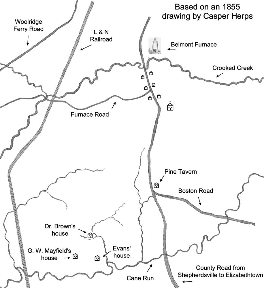
Along this road, from north to south, Herps located the Belmont Furnace (which still exists today), the church that served the workers there, and the location where a road branched off to the southeast toward the small town of Boston in Nelson County. He also drew in a small symbol of a house located just before you reach the Boston Road, and he labeled it as the Pine Tavern, which tells us that the place was there at that time.
But who built it, and when was it built? To try answering those questions, we needed to dig deeper into the county's past. We began with an early settler named Peter Gunterman who was also known as Peter Countryman in some records.
We know that at some point he owned the tract of land where the Pine Tavern was located, for his daughters Sarah Tabb and Nancy Price sold their rights to his estate of 200 acres to Eli Burch on 23 Jan 1835. The deed states that Burch was to have "the said tract or parcel of land and so as aforesaid described, called the Pine Tavern."
Various sources indicate that Peter Gunterman died on 12 Apr 1814 in Bullitt County. This corresponds with the Bullitt County tax records that show his son George in charge of his estate of 200 acres on Cane Run in the 1814 record.
Tracing back in those records, we find that Peter Gunterman is first listed as the owner of 200 acres on Cane Run in 1802. The tract is said to have been surveyed in the name of John Carr. However, we have not been able to find this survey; nor have we found a deed for the land in Gunterman's name. Nevertheless, he clearly possessed it from 1802-1814 according to the tax records. But did he build the Pine Tavern?
On 7 Feb 1814, the County Court [Order Book D, page 36] "ordered that Jacob Shawler be appointed surveyor of part of the public road which lies between Canada's Mill & the Pine Tavern." Thus we know for certain that the tavern existed by then and prior to Gunterman's death.
A search of Court Order Book A (1797-1800) fails to find any tavern license issued to anyone at Pine Tavern, suggesting that the place had not yet been built.
Peter had a home on his 200 acres by 4 Jul 1808, for in Court Order Book C, page 26 was recorded then "Ordered William Stark as surveyor of part of road from Shepherdsville to mouth of Beech fork from Wilson's Creek to Peter Guntryman's home." While not certain, it seems likely that this was where the Pine Tavern would be.
Unfortunately, this seems to be as close as we can come to identifying the Pine Tavern's origin. Order Book B which would cover the years 1801-1807 is missing. It seems likely that that would be the period of time in which a tavern license for the Pine Tavern would have been issued, but we will never know.
The Pine Tavern took on political significance in 1825 when the Kentucky General Assembly passed an act creating a new election precinct in Bullitt County. Previously election voting was held in either the county seat of Shepherdsville or, by 1820, the town of Mount Vernon (later known as Mount Washington).
This new precinct lay within the boundary "beginning at the mouth of Wilson's creek, on the Rolling Fork; thence up said creek, to the mouth of Overall's Fork; thence up said creek, to the dividing ridge between said fork and Crooked Creek; thence down Crooked Creek, to the Rolling Fork; thence up the Rolling Fork, to the beginning."
Voting would take place "at the house now occupied by Isaac Price, known by the name of the Pine Tavern."
The tavern was still owned by the heirs of Peter Gunterman, and it is possible that Isaac Price was a kinsman of Nancy Price's husband Samuel. If Isaac was acting as the tavern's proprietor, his day's were numbered, as his widow Eleanor was appointed to administer his estate on 3 Jul 1826.
While there were undoubtedly others earlier, Eli Burch is the first tavern keeper we've identified at the Pine Tavern. He obtained a tavern license at his home on 19 Jan 1829 [Order Book E, page 190], and apparently kept it until his death in 1838, after which time his widow Sarah Burch "showed herself qualified to keep a tavern at her house on the road leading from Shepherdsville to Elizabethtown" and obtained her own license on 19 Mar 1838. [Order Book F, page 36]
Eli and Sarah Burch had apparently leased the tavern from the Gunterman heirs as early as 1829, and then bought it from them on 23 Jan 1835.
After Sarah's death, Joseph Brown was named her estate administrator on 11 May 1840 [Order Book G, page 98]. Eli and Sarah's daughter Elizabeth had married Zadock L. Brown in January. Joseph was either grandfather or brother to Zadock as both had that name. On 11 Jan 1841 [Order Book G, page 142], Joseph received his tavern license, "granted him to keep a tavern at his house in this county at the house called the Pine Tavern on the Elizabethtown Road."
In January 1848, Eli's daughter Martha Burch Shawler sold her interest in the land to her brother-in-law, Zadock Brown. Then by April 1851, Brown and Francis A. Burch had bought up the rest of the interests of Eli Burch's descendants, and they signed a deed dividing the land between themselves with Brown getting the northern two-thirds including the part that included the Pine Tavern.
In January 1853, Zadok Brown sold his part of the land to Wilhite Carpenter who would continue to own it until it was sold to Elijah McCubbins in 1892.
Wilhite's elder brother, James Madison Carpenter, kept a tavern at the Pine Tavern, for he was granted licenses in both 1853 and 1854 that specially mentioned the place. And he was paid annually for hosting the election there as well.
But getting back to the time shortly after Casper Herps' 1855 plat, Lebanon Junction was established around 1857, and as it grew the road from Shepherdsville to Elizabethtown was altered to pass through the new town.
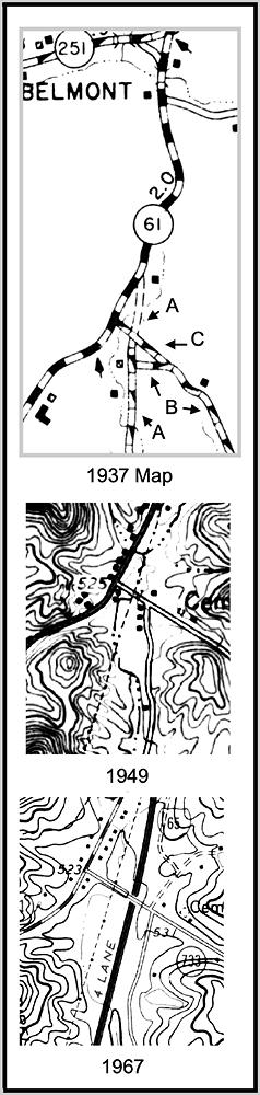
A clip from a 1937 Bullitt County map, shown here, will help you see this road change. The original road to Elizabethtown is labeled "A" and the original road to Boston is labeled "B." The new route for the Boston road to connect to the new road to Lebanon Junction is labeled "C."
Comparing the two drawings suggests that the Pine Tavern might have been located within the small triangle of land southwest of the new connecting road ("C"), or perhaps even within the new roadway itself.
Then by comparing the 1949 map with the 1967 map, also shown here, and taking note of the location of the pipeline shown on both maps, it appears that the Interstate (then a 4 lane highway) could possibly encroach into the space formerly occupied by the tavern.
Regardless of our speculation, it is clear that it once occupied a spot in this general vicinity.
It appears to have been the site for elections during much of its history, but with the growth of Lebanon Junction that came to an end in 1885. In August [Court Order Book L, page 527], M. J. Cockerell petitioned the Court to move the voting place to that town, and in October [Court Order Book L, page 537] it was officially moved "from the old Pine Tavern to Lebanon Junction at the Masonic building and the lower floor thereof."
The tavern's days were numbered, but its name lasted much longer. The voting district continued to be named the Pine Tavern District as late as the 1950 census, and the Pine Tavern Road still welcomes travelers today.
And if I'm right, and the widened interstate highway has encroached upon the former location of the tavern, then perhaps the old place greets thousands of visitors each day, if only for a moment.
Copyright 2024 by Charles Hartley, Shepherdsville KY. All rights are reserved. No part of the content of this page may be included in any format in any place without the written permission of the copyright holder.
The Bullitt County History Museum, a service of the Bullitt County Genealogical Society, is located in the county courthouse at 300 South Buckman Street (Highway 61) in Shepherdsville, Kentucky. The museum, along with its research room, is open 10 a.m. to 4 p.m. Monday through Friday. Saturday appointments are available by calling 502-921-0161 during our regular weekday hours. Admission is free. The museum, as part of the Bullitt County Genealogical Society, is a 501(c)3 tax exempt organization and is classified as a 509(a)2 public charity. Contributions and bequests are deductible under section 2055, 2106, or 2522 of the Internal Revenue Code. Page last modified: 12 Sep 2024 . Page URL: bullittcountyhistory.org/memories/pine-tavern.html