
On 1 Aug 1834, Jonathan Rowland sold these two tracts of land to Robert M. Smith as shown below. The first, purchased from Popes and Breckinridge, contained 151.5 acres, and the second, purchased from Benjamin Summers, included 102.5 acres. On 1 Oct 1835, Smith sold both tracts to Rufus K. Summers.
Bullitt County Deed Book H, Pages 89-91
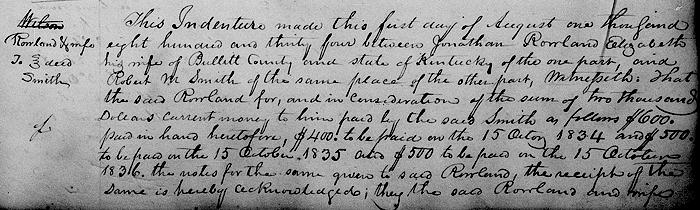
This indenture made this first day of August 1834 between Jonathan Rowland, Elizabeth his wife of Bullitt County and state of Kentucky of the one part and Robert M. Smith the same place of the other part.
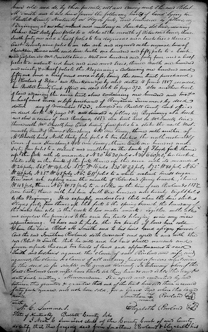
Witnesseth that the said Rowland for and in consideration of the sum of $2000 current money to him paid by the said Smith as follows, $600 put in hand heretofore, $400 to be paid on 15 October 1834, and $500 to be paid on 15 October 1835, and $500 to be paid on 15 October 1836, the notes for the same given to said Rowland, the receipt of the same is hereby acknowledged; they the said Rowland and wife have sold, and do by these presents sell and convey unto the said Robert M. Smith and to his heirs forever the following tracts of land lying in Bullitt County, Kentucky on Floyd's Fork and bounded as follows, viz.
Beginning at an elm, walnut and mulberry on Shanklin's old line, running thence East 65 poles to a stake at the mouth of Robinson's lane, thence South 41 1/2 poles to two dogwoods and a beech trees, thence East 79 poles to an elm, ash and dogwood on the original line of Shanklin, thence with said line South 150 poles to a beech and poplar in McDowell's line, West 144 1/2 poles to a walnut, redbud and ironwood trees, thence North 190 1/2 poles to the beginning, containing 151 1/2 acres more or less, being the same tract purchased by Rowland of Popes and Breckinridge by deed dated 4 Jun 1817, recorded in Bullitt County Court office in Deed Book C, page 373.
Also another tract of land adjoining the same tract above containing 102 1/2 acres more or less purchased of Benjamin Summers by deed dated __ day of November 1833, recorded in Bullitt County Court office in Deed Book H, page 38, and bounded as follows, viz.
Beginning at a beech and elm, corner of said Rowland's 151 1/2 acre tract and on McDowell's line, thence with McDowell's line East 74 poles to a stake, the NorthWestwardly corner of said Stansberry's 400 acres survey, thence East 164 poles to a walnut and mulberry on the bank of Floyd's Fork, thence up the fork with its meanders North 20° East 20 poles, North 34° East 60 poles to a crooked white oak on the bank of the fork, thence up the same with its meanders West 26 poles, South 65° West 14 poles, South 55° West 16 poles, South 30° West 22 poles, South 72° West 80 poles, North 65° West 40 poles, North 25° West 45 poles, North 6° East 11 poles to a white walnut, small sugar tree, and ash sapling near the mouth of Robinson's spring branch, thence West 48 poles, thence North 67° West 50 poles to a stake in the line of said Rowland's 151 1/2 acre tract, thence with his line South 128 poles to the beginning.
It is expressly understood that where the line strikes Floyd's Fork from thence up the fork to the spring branch the boundary of the land here sold is the creek to low water mark; together with all and singular the premises to the said to tracts belonging or in wise appertaining.
To have and to hold the two tracts of land here sold to him the said Robert M. Smith and to his heirs and assigns forever. And said Jonathan Rowland doth covenant and agree to and with the said Robert M. Smith that he will and his heirs shall warrant and forever defend the said two tracts of land and appurtenances to said Smith and his heirs against the claim of said Rowland, and against the claim or claims of all and every person or persons whatsoever by this deed in fee simple with general warranty.
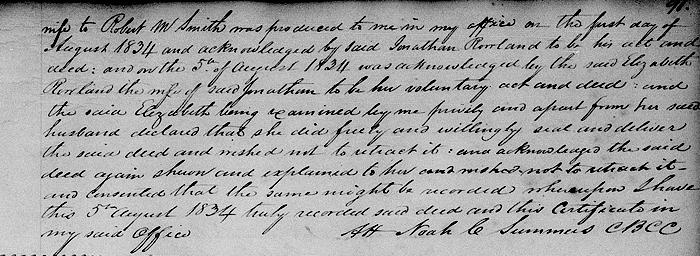
In testimony, whereof the said Rowland and wife have hereto set their hands and seals the day and date first written. Memorandum: it is agreed and understood by and between the grantors and grantee that out of the tract here sold there is reserved 40 feet square, and not here sold, for a graveyard where the same now is. (signed by grantors)
If you, the reader, have an interest in any particular part of our county history, and wish to contribute to this effort, use the form on our Contact Us page to send us your comments about this, or any Bullitt County History page. We welcome your comments and suggestions. If you feel that we have misspoken at any point, please feel free to point this out to us.
The Bullitt County History Museum, a service of the Bullitt County Genealogical Society, is located in the county courthouse at 300 South Buckman Street (Highway 61) in Shepherdsville, Kentucky. The museum, along with its research room, is open 10 a.m. to 4 p.m. Monday through Friday. Saturday appointments are available by calling 502-921-0161 during our regular weekday hours. Admission is free. The museum, as part of the Bullitt County Genealogical Society, is a 501(c)3 tax exempt organization and is classified as a 509(a)2 public charity. Contributions and bequests are deductible under section 2055, 2106, or 2522 of the Internal Revenue Code. Page last modified: 06 Mar 2026 . Page URL: bullittcountyhistory.org/bchistory/rowland-smith.html