
In June 1835, John H. Baker finalized the purchase of Cornelius Comyges' undivided share of the forge tracts near Shepherdsville. Specifically, these where the 150 and 50 acre tracts that John W. Beckwith and Frederic W. S. Grayson had purchased from Adam Shepherd, noted on another page.
The agreement to buy the land was made in April 1833 when Baker made the first payment to Comyges' attorney James Guthrie, as indicated in the deed transcription below. The 50 acre tract included the Shepherdsville lots 65-76 along the riverfront. This deed also delivered the 250 acre tract as well.
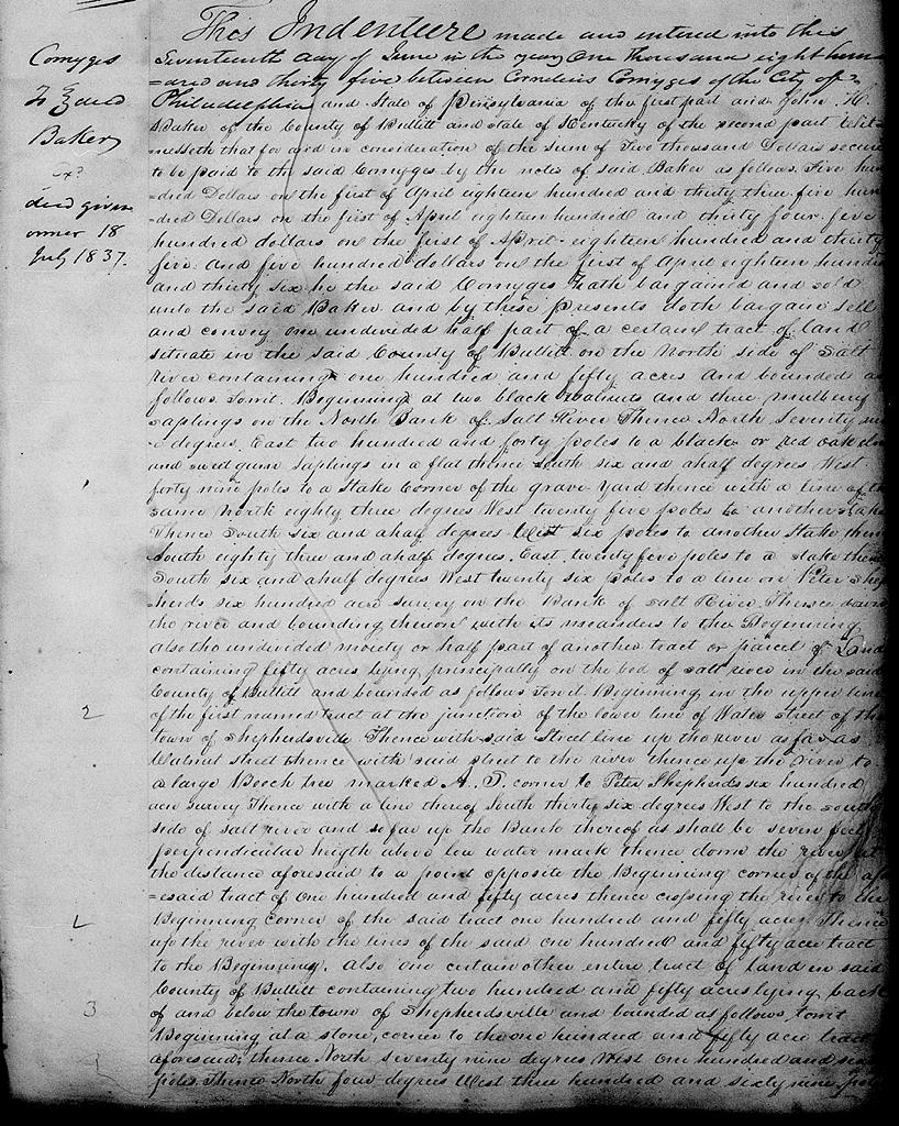
Bullitt County Deed Book H, Pages 219-220
This indenture made and entered into this 17th day of June in the year 1835 between Cornelius Comyges of the city of Philadelphia and state of Pennsylvania of the first part and John H. Baker of the county of Bullitt and state of Kentucky of the second part.
Witnesseth that for and in consideration of the sum of $2000 secured to be paid to the said Comyges by the notes of said Baker as follows: $500 on the first of April 1833, $500 on the first of April 1834, $500 on the first of April 1835, and $500 on the first of April 1836, he the said Comyges hath bargained and sold unto the said Baker, and doth by these presents doth bargain, sell and convey one undivided half part of a certain tract of land situate in the said county of Bullitt on the north side of Salt River containing 150 acres and bounded as follows, to wit, Beginning at two black walnuts and three mulberry saplings on the north bank of Salt River, thence North 79° East 240 poles to a red or black oak, elm and sweet gum saplings in a flat, thence South 6 1/2° West 49 poles to a stake, corner to the grave yard, thence with a line of the same North 83° West 25 to another stake, thence South 6 1/2° West 6 poles to another stake, thence South 83 1/2° East 25 poles to a stake, thence South 6 1/2° West 26 poles to a line on Peter Shepherd's 600 acre survey on the bank of Salt River, thence down the river and binding thereon with its meanders to the beginning.
Also the undivided moiety or one half part of another tract or parcel of land containing 50 acres lying principally on the bed of Salt River in the said County of Bullitt and bounded as follows, to wit. Beginning in the upper line of the first named tract at the junction of the lower line of Water Street of the town of Shepherdsville, thence with said street line up the river as far as Walnut Street, thence with said street to the river, thence up the river to large beech tree marked A.S. corner to Peter Shepherd's 600 acre survey, thence with the line thereof South 36° West to the south side of Salt River and so far up the bank as shall be seven feet perpendicular height above low water mark, thence down said river at the distance aforesaid to a point opposite the beginning course of the aforesaid tract of 150 acres, thence crossing the river to the beginning corner of the said tract 150 acres, thence up the river with the line of the said 150 acres tract to the beginning.
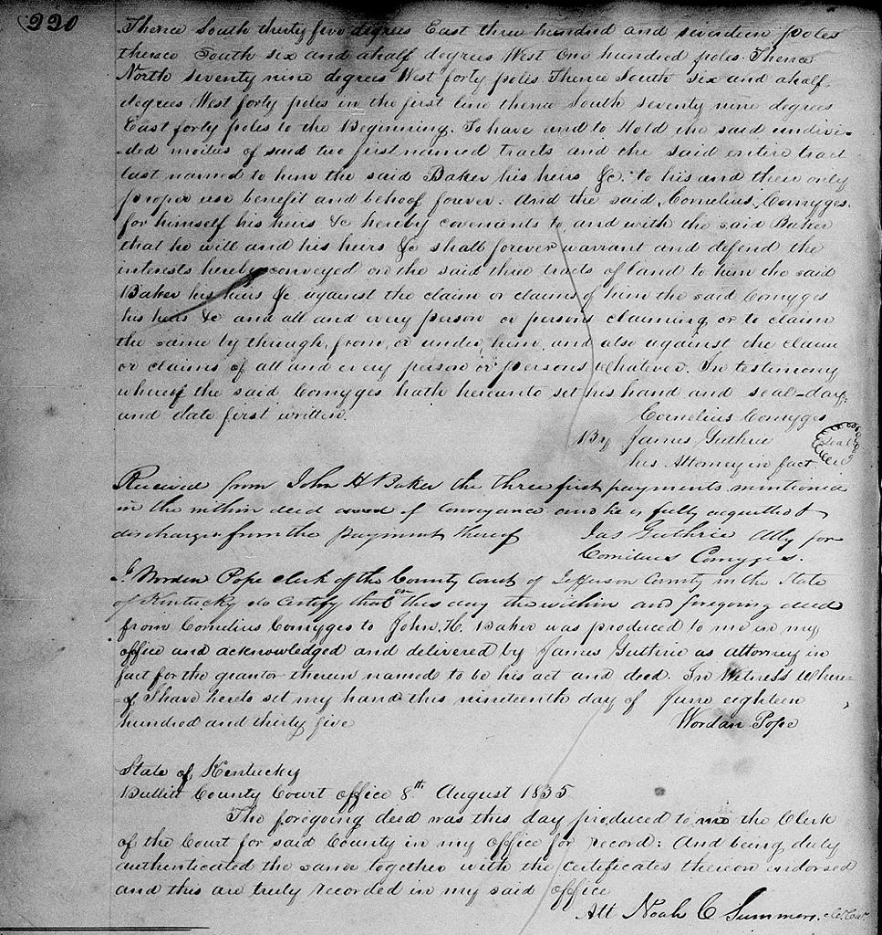
Also one certain other entire tract of land in said county of Bullitt containing 250 acres, lying back of and below the town of Shepherdsville and bounded as follows, to wit. Beginning at a stone, corner to the 150 acre tract aforesaid, thence North 79° West 160 poles, thence North 4° West 369 poles thence South 35° East 317 poles thence South 6 1/2° West 100 poles, thence North 79° West 40 poles, thence South 6 1/2° West 40 poles in the first line, thence South 79° East 40 poles to the beginning.
To have and to hold the said undivided moieties of said two first named tracts and the said entire tract last named to him the said Baker his heirs &c to his and their only proper use, benefit and behoof forever. And the said Cornelius Comyges for himself, his heirs &c hereby covenants to and with the said Baker that he will and his heirs &c shall forever warrant and defend the interests hereby conveyed on he said three tracts of land to him the said Baker, his heirs &c against the claim or claims of him the said Comyges his heirs &c and all and every person or persons claiming or to claim the same by, through, from or under him, and also against the claim or claims of all and every person or persons whatever. In testimony whereof the said Comyges hath hereunto set his hand and seal, day and date first written. (signed) Cornelius Comyges by James Guthrie, his attorney in fact.
Received from John H. Baker the three first payments mentioned in the within deed of conveyance and he is fully acquitted and discharged from the payment thereof. (signed) James Guthrie, attorney for Cornelius Comyges.
If you, the reader, have an interest in any particular part of our county history, and wish to contribute to this effort, use the form on our Contact Us page to send us your comments about this, or any Bullitt County History page. We welcome your comments and suggestions. If you feel that we have misspoken at any point, please feel free to point this out to us.
The Bullitt County History Museum, a service of the Bullitt County Genealogical Society, is located in the county courthouse at 300 South Buckman Street (Highway 61) in Shepherdsville, Kentucky. The museum, along with its research room, is open 10 a.m. to 4 p.m. Monday through Friday. Saturday appointments are available by calling 502-921-0161 during our regular weekday hours. Admission is free. The museum, as part of the Bullitt County Genealogical Society, is a 501(c)3 tax exempt organization and is classified as a 509(a)2 public charity. Contributions and bequests are deductible under section 2055, 2106, or 2522 of the Internal Revenue Code. Page last modified: 12 Apr 2026 . Page URL: bullittcountyhistory.org/bchistory/comyges-baker.html