
James Brend of Richmond, Virginia had 977 acres surveyed by Benjamin Stansbury on 17 Apr 1781 that lay to the southwest of Peter Shepherd's 600 acre tract on south side of Salt River. It also adjoined the survey of James Honey on the east. He then signed the survey over to Thomas Brend. Then in 1799, Thomas Brend sold the tract to John Hughes who resided in Jefferson County. A transcription of the deed followed by an image of it is shown below.
Bullitt County Deed Book A, pages 218-219
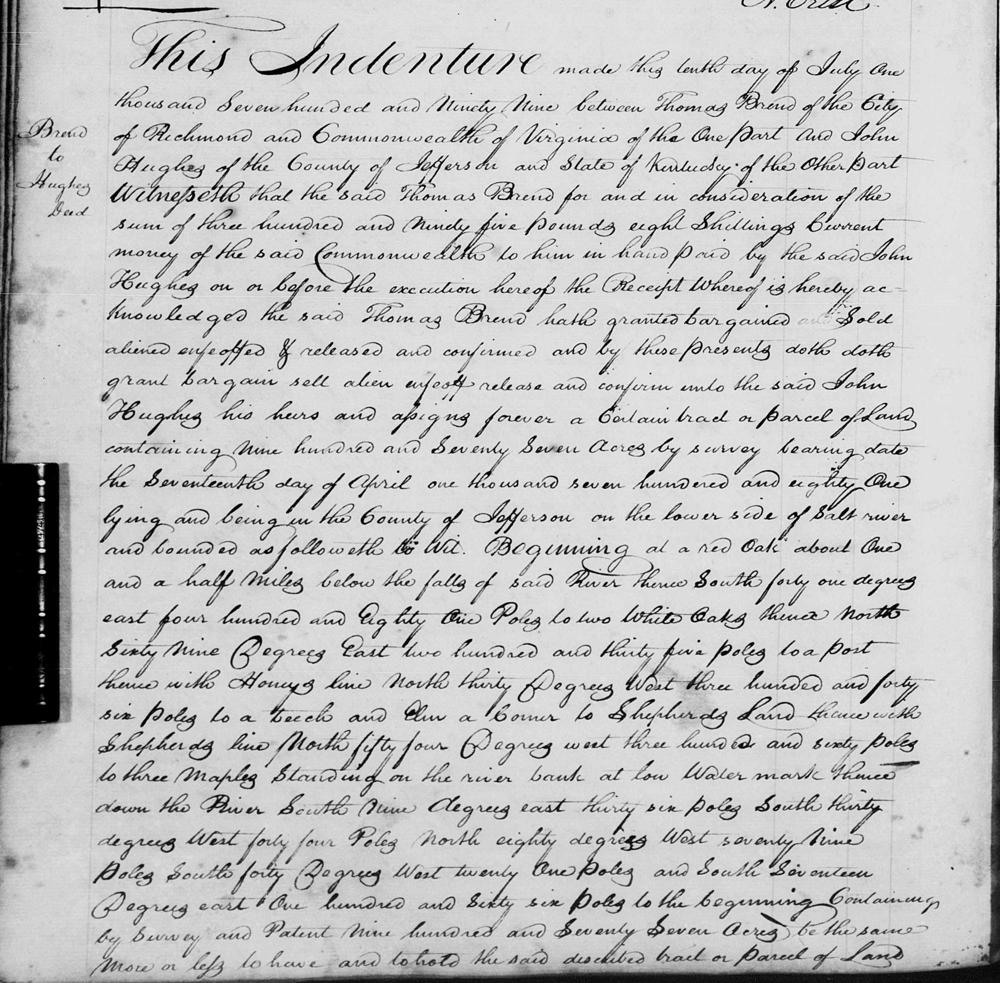
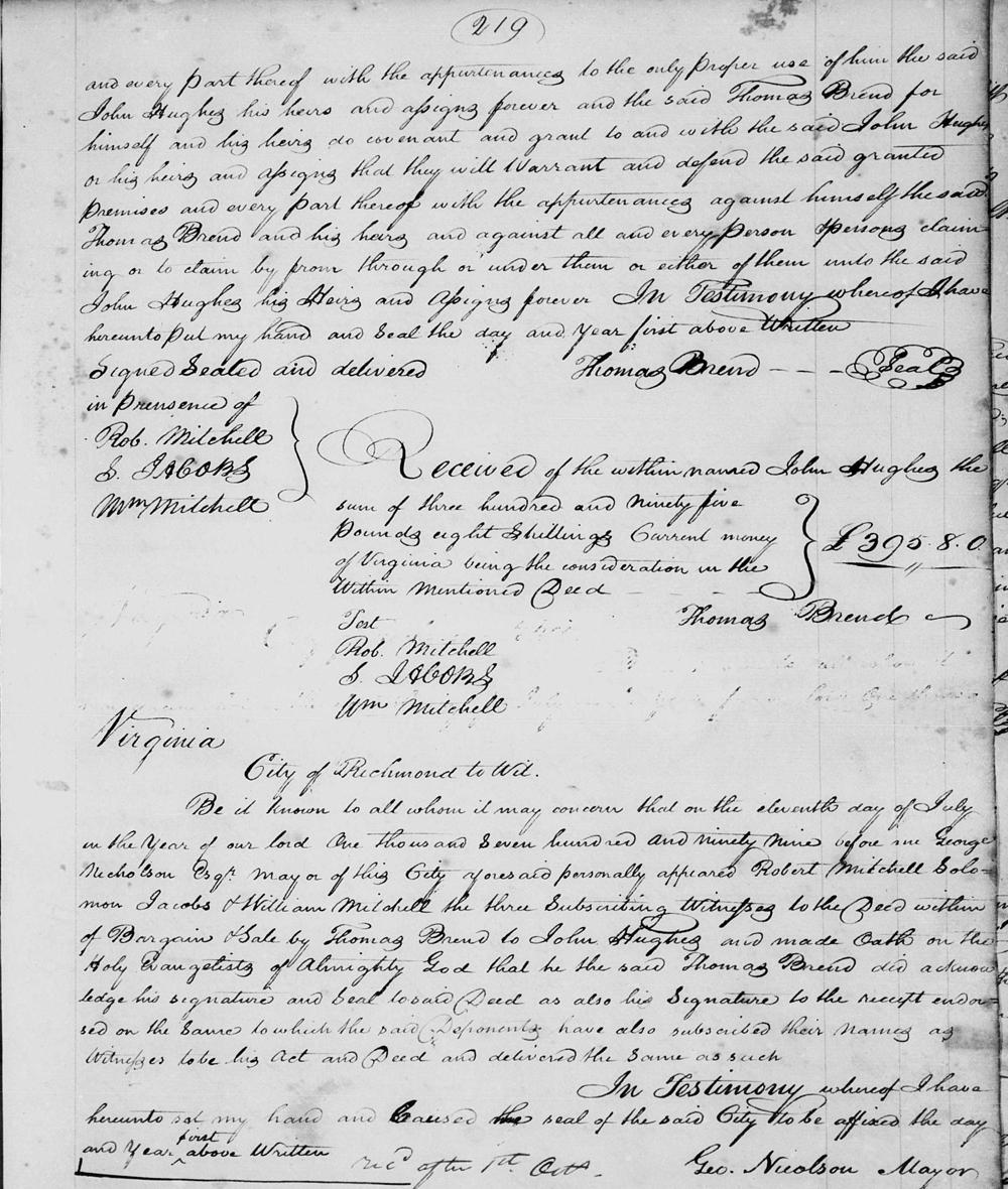
This indenture made this tenth day of July one thousand seven hundred and ninety nine between Thomas Brend of the City of Richmond and Commonwealth of Virginia of the one part and John Hughes of the County of Jefferson and State of Kentucky of the other part. Witnesseth that the said Thomas Brend for and in consideration of the sum of three hundred and ninety five pounds eight shillings current money of the said Commonwealth to him in hand paid by the said John Hughes on or before the execution hereof the receipt whereof is hereby acknowledged the said Thomas Brend hath granted bargained sold aliened enfeoffed & released and confirmed and by these presents doth grant bargain sell alien enfeoff release and confirm unto the said John Hughes his heirs and assigns forever a certain tract or parcel of land containing nine hundred and seventy seven acres by survey bearing date the seventeenth day of April one thousand seven hundred and eighty one lying and being in the County of Jefferson on the lower side of Salt River and bounded as followeth to wit. Beginning at a red oak about one and a half miles below the falls of said river, thence South forty one degrees East four hundred and eighty one poles to two white oaks, thence North sixty nine degrees East two hndred and thirty five poles to a post, thence with Honey's line North thirty degrees West three hundred and forty six poles to a beech and elm a corner to Shepherd's land, thence with Shepherd's line North fifty four degrees West three hundred and sixty poles to three maples standing on the river bank at low water mark, thence down the river South nine degrees East thirty six poles, South thirty degrees West forty four poles, North eighty degrees West seventy nine poles, South forty degrees West twenty one poles, and South seventeen degrees East one hundred and sixty six poles to the beginning, containing by survey and patent nine hundred and seventy seven acres be the same more or less to have and to hold the said described tract or parcel of land and every part thereof with the appurtenances to the only propre use of him the said John Hughes his heirs and assigns forever and the said Thomas Brend for himself and his heirs do covenant and grant to and with the said John Hughes or his heirs and assigns that they will warrant and defend the said granted premises and every part thereof with the appurtenances against himself the said Thomas Brend and his heirs and against all and every person or persons claiming or to claim by from through or under them or either of them unto the said John Hughes his heirs and assigns forever. In testimony whereof I have hereunto put my hand and seal the day and year first above written. (signed) Thomas Brend Signed sealed and delivered in presence of Rob Mitchell, S. Jacobs, Wm Mitchell
Received of the within named John Hughes the sum of three hundred and ninety five pounds eight shillings current money of Virginia being the consideration oin the within mentioned deed. (signed) Thomas Brend. Teste: Rob Mitchell, S. Jacobs, Wm Mitchell.
Virginia, City of Richmond to wit.
Be it known to all whom it may concern that on the eleventh day of July in the year of our Lord one thousand seven hundred and ninety nine before me George Nicholson Esquire, mayor of this city aforesaid personally appeared Robert Mitchell, Solomon Jacobs & William Mitchell the three subscribing witnesses to the deed within of bargain & sale by Thomas Brend to John Hughes and made oath on the Holy Evangelists of Almighty God that he the said Thomas Brend did acknowledge his signature and seal to said deed as also his signature to the receipt endorsed on the same to which the said deponents have also subscribed their names as witnesses to be his act and deed and delivered the same as such. In testimony whereof I have hereunto set my hand and caused the seal of the said city to be affixed the day and year firs above written. (signed) Geo. Nicolson, Mayor
Deed
If you, the reader, have an interest in any particular part of our county history, and wish to contribute to this effort, use the form on our Contact Us page to send us your comments about this, or any Bullitt County History page. We welcome your comments and suggestions. If you feel that we have misspoken at any point, please feel free to point this out to us.
The Bullitt County History Museum, a service of the Bullitt County Genealogical Society, is located in the county courthouse at 300 South Buckman Street (Highway 61) in Shepherdsville, Kentucky. The museum, along with its research room, is open 10 a.m. to 4 p.m. Monday through Friday. Saturday appointments are available by calling 502-921-0161 during our regular weekday hours. Admission is free. The museum, as part of the Bullitt County Genealogical Society, is a 501(c)3 tax exempt organization and is classified as a 509(a)2 public charity. Contributions and bequests are deductible under section 2055, 2106, or 2522 of the Internal Revenue Code. Page last modified: 12 Apr 2026 . Page URL: bullittcountyhistory.org/bchistory/brend-hughes.html