
Below is a drawing showing the approximate location of various Brashear tracts. Please note that the locations of borders are only rough estimates. There is only one really good location point given, the upstream end of what is now Peacock Island, across from the mouth of Cedar Creek (marker X on the map). Using that as my reference point, each of the other surveys was calculated based on the information given in the surveys themselves.
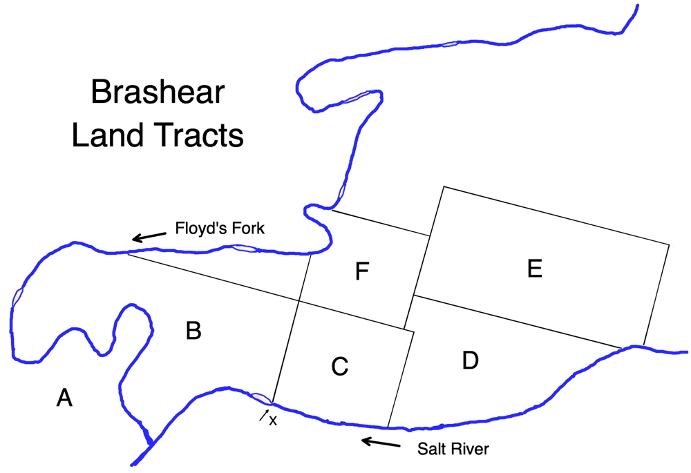
Tract A - Nicholas Brashear, son of William Brashear, patented the 400 acre tract where Brashear's Station stood near the juncture of Salt River and Floyd's Fork. This patent was based on a Virginia treasury warrant. Images of the original survey and of the recorded patent, along with a transcription of it, may be viewed on this page.
Tract B - Nicholas Brashear, son and heir of William Brashear, patented a 1000 acre tract north of Salt River and east of Floyd's Fork based on a Virginia preemption warrant in his father's name. Images of the original survey and of the recorded patent, along with a transcription of it, may be viewed on this page.
Tract C - Nicholas Ray Brashear, son and heir of William Brashear, also patented a 400 acre tract north of Salt River and east of his 1000 acre tract based on a Virginia settlement warrant in his father's name. Images of the original survey and of the recorded patent, along with a transcription of it, may be viewed on this page.
Tracts D, E, F were surveyed in the name of Marsham Brashear, a cousin of William Brashear. Tract D was based on his 400 acre settlement warrant. Tracts E and F were both based on his 1000 acre preemption warrant. Both of the latter two were sold to Richard Simmons and patented in his name. More information about Marsham Brashear's lands can be seen on this page.
The Google map below shows the general area in which these tracts were patented.
If you, the reader, have an interest in any particular part of our county history, and wish to contribute to this effort, use the form on our Contact Us page to send us your comments about this, or any Bullitt County History page. We welcome your comments and suggestions. If you feel that we have misspoken at any point, please feel free to point this out to us.
The Bullitt County History Museum, a service of the Bullitt County Genealogical Society, is located in the county courthouse at 300 South Buckman Street (Highway 61) in Shepherdsville, Kentucky. The museum, along with its research room, is open 10 a.m. to 4 p.m. Monday through Friday. Saturday appointments are available by calling 502-921-0161 during our regular weekday hours. Admission is free. The museum, as part of the Bullitt County Genealogical Society, is a 501(c)3 tax exempt organization and is classified as a 509(a)2 public charity. Contributions and bequests are deductible under section 2055, 2106, or 2522 of the Internal Revenue Code. Page last modified: 09 May 2026 . Page URL: bullittcountyhistory.org/bchistory/brashearmap.html