
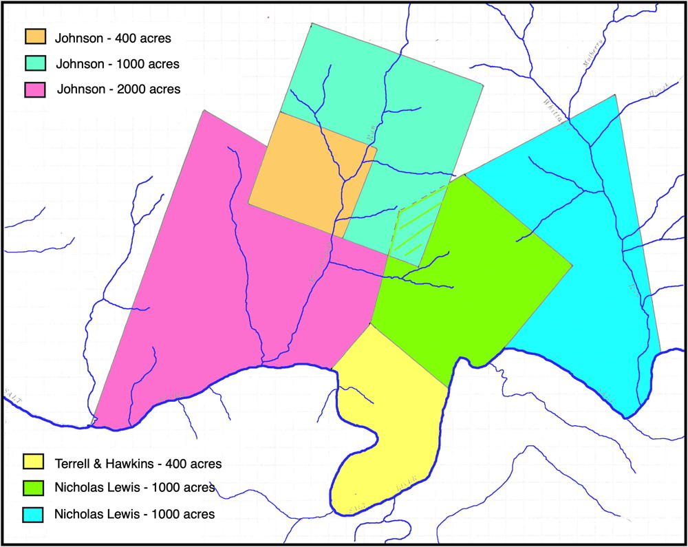
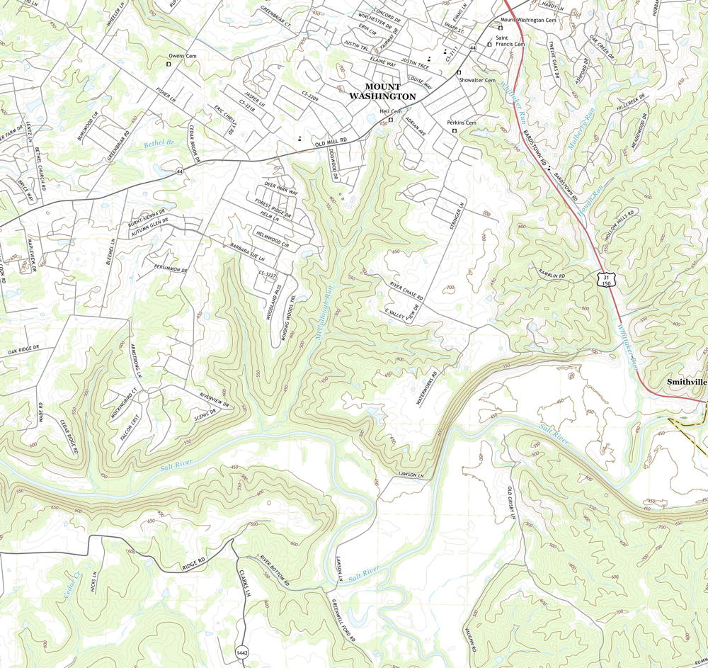
On 22 Apr 1784, Isaac Cox surveyed 1000 acres for Nicholas Lewis adjoining Hawkins' preemption that lay opposite the mouth of Cox's Creek. Lewis obtained a deed to this tract on 2 Dec 1785. The map below shows the approximate location of this tract (colored green), as well as that of the Hawkins tract, the adjoining Johnson tracts, and also Lewis' other tract to the east of this one. The second map below is part of topographic maps drawn in 2019 that show the same region This will help you locate these tracts more closely. Lewis sold this tract to Henry Crist in 1822.
Survey
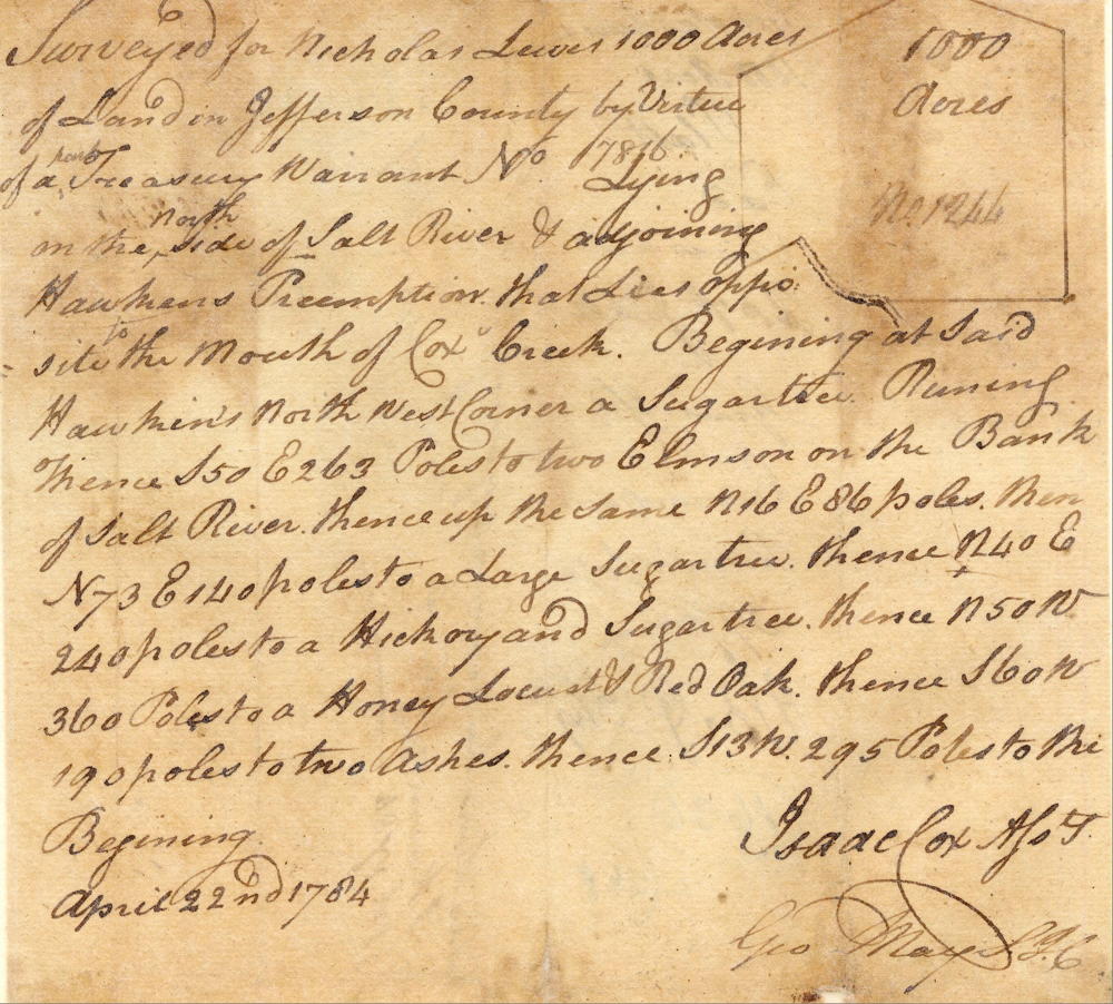
Surveyed for Nicolas Lewis 1000 acres of land in Jefferson County by virtue of part of a treasury warrant number 7816 on the north side of Salt River and adjoining Hawkins' preemption that lies opposite the mouth of Cox's Creek. Beginning at said Hawkin's north west corner of sugar tree running thence South 50° East 263 poles to two elms on the bank of Salt River, thence up the same North 16° East 86 poles, then North 73° East 140 poles to a large sugar tree, thence North 40° East 240 poles to a hickory and sugar tree, thence North 50° West 360 poles to a honey locust and red oak, thence South 60° West 190 poles to two ashes, thence South 13° West 295 poles to the beginning. April 22nd 1784. Isaac Cox, surveyor.
Deed
Virginia Grant Book 4, pages 407-408
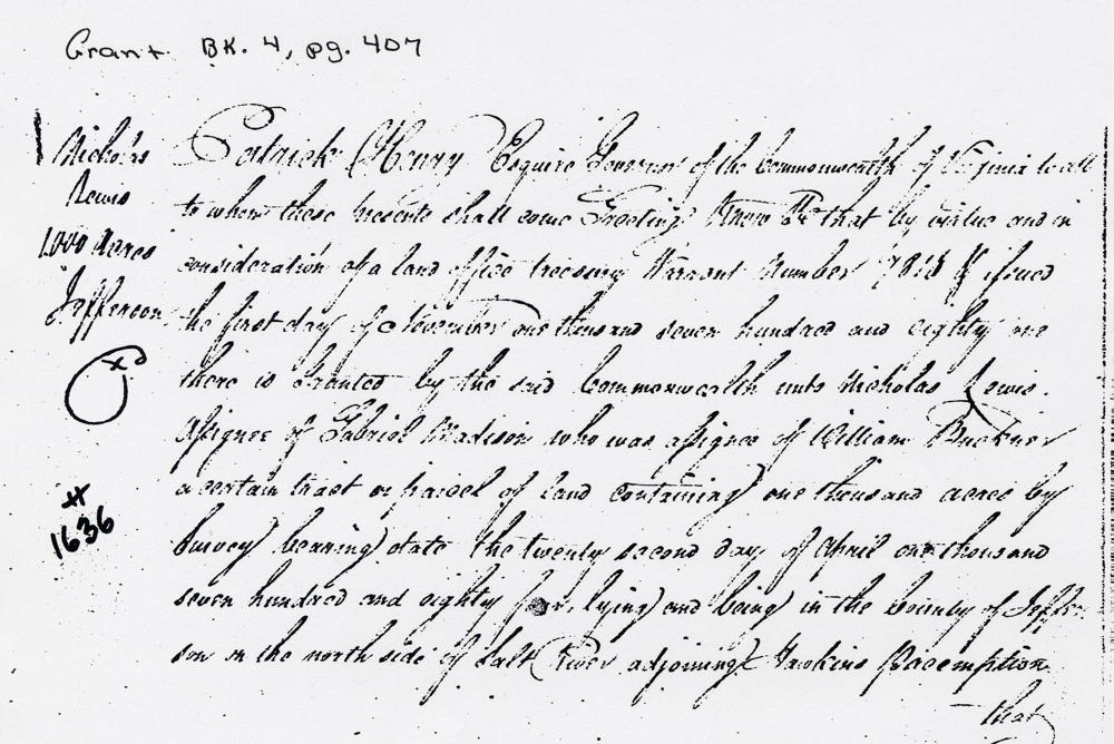
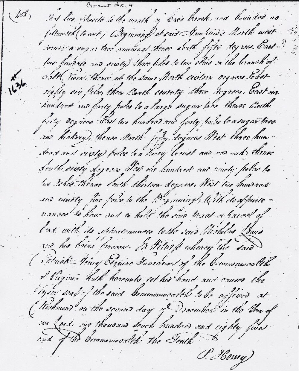
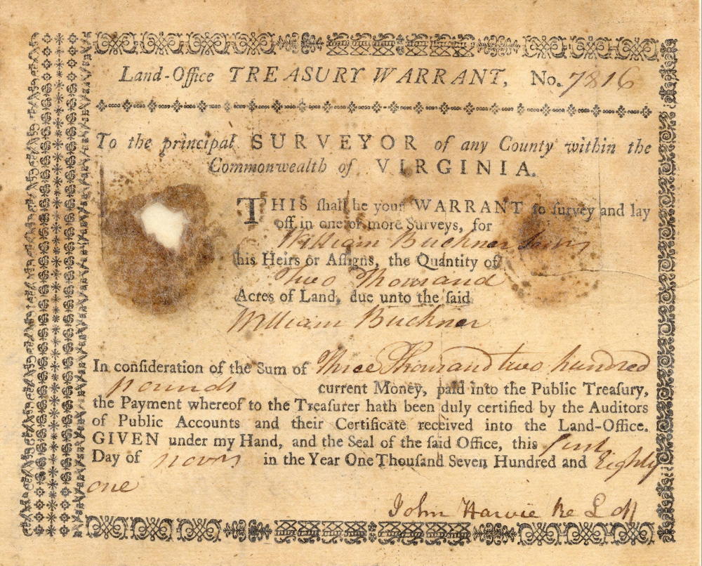
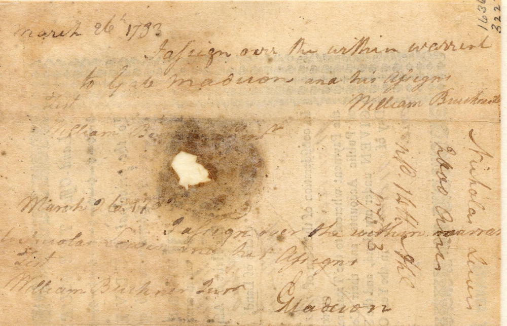
Patrick Henry Esquire, Governor of the Commonwealth of Virginia, to all to whom these presents shall come, greeting. Know ye that by virtue and in consideration of a preemption treasury warrant No. 7816, issued the 1st day of November 1781, there is granted by the said Commonwealth unto Nicholas Lewis, assignee of Gabriel Madison who was assignee of William Buckner, a certain tract or parcel of land containing 1000 acres by survey bearing date the 22nd day of April 1784, lying and being in the County of Jefferson on the north side of Salt River adjoining Hawkins' preemption that lies opposite to the mouth of Cox's Creek and bounded as followeth (to wit). Beginning at said Hawkin's north west corner of sugar tree running thence South 50° East 263 poles to two elms on the bank of Salt River, thence up the same North 16° East 86 poles, then North 73° East 140 poles to a large sugar tree, thence North 40° East 240 poles to a hickory and sugar tree, thence North 50° West 360 poles to a honey locust and red oak, thence South 60° West 190 poles to two ashes, thence South 13° West 295 poles to the beginning with its appurtenances. To have and to hold the said tract or parcel of land with its appurtenances, to the said Nicholas Lewis and his heirs forever. In witness whereof the said Patrick Henry Esquire, Governor of the Commonwealth of Virginia, hath hereunto set his hand and caused the lesser seal of the said Commonwealth to be affixed at Richmond on the second day of December in the year of our Lord 1785, and of the Commonwealth the 10th. (signed) P. Henry
Warrant
If you, the reader, have an interest in any particular part of our county history, and wish to contribute to this effort, use the form on our Contact Us page to send us your comments about this, or any Bullitt County History page. We welcome your comments and suggestions. If you feel that we have misspoken at any point, please feel free to point this out to us.
The Bullitt County History Museum, a service of the Bullitt County Genealogical Society, is located in the county courthouse at 300 South Buckman Street (Highway 61) in Shepherdsville, Kentucky. The museum, along with its research room, is open 10 a.m. to 4 p.m. Monday through Friday. Saturday appointments are available by calling 502-921-0161 during our regular weekday hours. Admission is free. The museum, as part of the Bullitt County Genealogical Society, is a 501(c)3 tax exempt organization and is classified as a 509(a)2 public charity. Contributions and bequests are deductible under section 2055, 2106, or 2522 of the Internal Revenue Code. Page last modified: 21 Apr 2026 . Page URL: bullittcountyhistory.org/bchistory/1636-lewis.html