
On 8 Mar 1847, Quirey & Tyler conveyed all the property to the newly formed Shepherdsville Iron Manufacturing Company. This included the 50 acre tract in the river bed which also included Shepherdsville lots 65-76.
Bullitt County Deed Book L, Pages 109-111
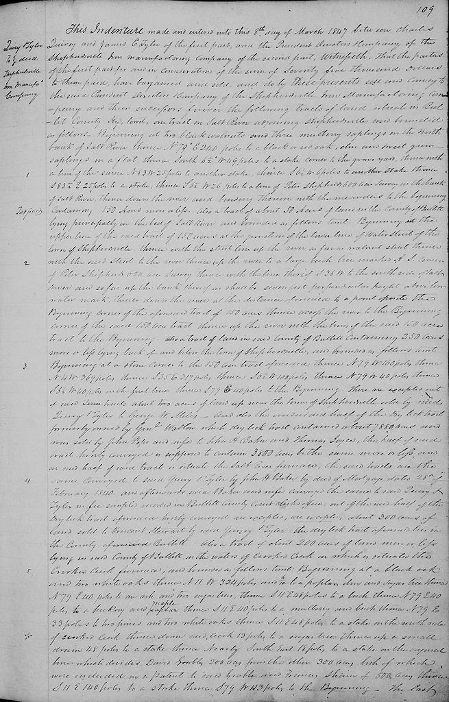
This indenture made and entered into this 8th day of March 1847 between Charles Quirey and James E. Tyler of the first part and the President, Directors and Company of the Shepherdsville Iron Manufacturing Company of the second part. Witnesseth that the parties of the first part for and in consideration of the sum of $75,000 to them paid, have bargained and sold, and do by these presents sell and convey to the said President, Directors and Company of the Shepherdsville Iron Manufacturing Company and their successors forever the following tracts of land situate in Bullitt County, Kentucky, to wit.
One tract on Salt River adjoining Shepherdsville and bounded as follows. Beginning at two black walnuts and three mulberry saplings on the north bank of Salt River, thence N 79° E 240 poles to a black or red oak, elm and sweet gum saplings in a flat, thence South 6½° W 49 poles to a stake corner to the grave yard, thence with a line of the same N 83° W 25 poles to another stake, thence S 6½° W 6 poles to another stake, thence S 83½° E 25 poles to a stake, thence S 6½° W 26 poles to a line of Peter Shepherd's 600 acre survey on the bank of Salt River, thence down the river and binding thereon with the meanders to the beginning containing 150 acres more or less.
Also a tract of about 50 acres of land in the County of Bullitt lying principally in the bed of Salt River and bounded as follows, to wit, beginning in the upper line of said tract of 150 acres at the junction of the lower line of Water Street of the town of Shepherdsville, thence with the street line up the river as far as Walnut street, thence with said street to the river, thence up the river to a large beech tree marked A.S., corner of Peter Shepherd's 600 acre survey, thence with the line thereof S 36° W to the south side of Salt River and so far up the bank thereof as shall be seven feet perpendicular height above low water mark, thence down the river at the distance aforesaid to opposite the beginning corner of the aforesaid 150 acres, thence across the river to the beginning corner of the said 150 acre tract, thence up the river with the lines of the said 150 acre tract to the beginning.
Also a tract of land in said County of Bullitt containing 250 acres more or less, lying back of and below the town of Shepherdsville and bounded as follows to wit. Beginning at a stone corner to the 150 acre tract aforesaid, thence N 79° W 160 poles, thence N 4° W 369 poles, thence S 35° E 317 poles, thence S 6½° W 100 poles, thence N 79° W 40 poles, thence S 6½° W 40 poles in the first line, thence S 79° E 40 poles to the beginning. There are excepted out of said lots about two acres of land up near the town of Shepherdsville sold by said Quirey & Tyler to George W. Miles.
And also the undivided half of the Dry Lick tract formerly owned by General Walton which Dry Lick tract contained about 7880 acres and was sold by John Pope and wife to John H. Baker and Thomas Joyce, the half of said tract hereby conveyed is supposed to contain 3800 acres, be the same more or less, and on said half of said tract is situate the Salt River furnace, the said tracts are the same conveyed to said Quirey & Tyler by John H. Baker by deed of mortgage dated 28th of February 1840, and afterwards said Baker and wife conveyed the same to said Quirey & Tyler in fee simple recorded in Bullitt County Court Clerk's office. Out of the said half of the Dry Lick tract aforesaid hereby conveyed are excepted about 300 acres of land sold to Vincent Stewart by said Quirey & Tyler. The Dry Lick tract aforesaid lies in the County of Bullitt.
Also a tract of about 200 acres of land more or less lying in said County of Bullitt on the waters of Crooked Creek on which is situated the Crooked Creek furnace, and bounded as follows to wit. Beginning at a black oak and two white oaks, thence N 11° W 324 poles and 6/10 to a poplar, elm and sugar tree, thence N 79° E 40 poles to an ash and two sugar trees, thence S 11° E 48 poles to a beech, thence N 79° E 40 poles to a hickory and maple, thence S 11° E 40 poles to a mulberry and beech, thence N 79° E 33 poles to two pines and two white oaks, thence S 11° E 48 poles to a stake on the south side of Crooked Creek, thence down said creek 13 poles to a sugar tree, thence up a small drain 48 poles to a stake, thence nearly southeast 18 poles to a stake on the original line which divides David Grable's 200 acres from the other 300 acres, both of which were included in a patent to said Grable and Frances Shain of 500 acres, thence S 11° E 140 poles to a stake, thence S 79° W 113 poles to the beginning. The last named tract of land hereby conveyed was conveyed to said Quirey & Tyler by N. C. Summers, commissioner, by deed dated 18th of April 1845.
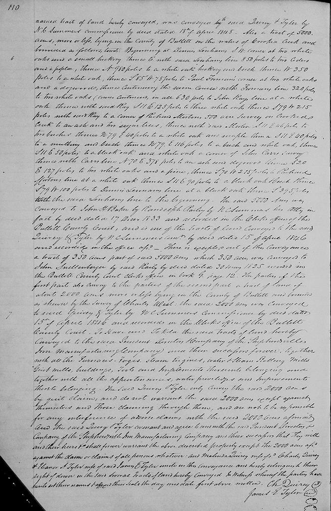
Also a tract of 5000 acres, more or less, lying in the county of Bullitt on the waters of Crooked Creek and bounded as follows, to wit. Beginning at Dennis Lenham's SW corner at two white oaks and a small hickory, thence East with said Lenham's line 850 poles to two cedars and a poplar, thence North 980 poles to a white oak, hickory and beech, thence West 350 poles to a white oak, thence S 85° W 75 poles to Paul Froman's corner at two white oaks and a dogwood, thence continuing the same course with Froman's line 320 poles to two white oaks (course continued in all 630 poles) to John Ray's line at a white oak, thence with said Ray S 11° E 125 poles to three white oaks, thence S 79° W 215 poles with said Ray to a corner of Richard Morton's 500 acre survey on Crooked Creek to a an ash and two sugar trees, thence with said Morton S 11° E 46 poles to two beeches, thence N 79° E 40 poles to a white oak and maple, thence S 11° E 40 poles to a mulberry and beech, thence N 79° E 116 poles to a beechand white oak, thence S 11° E 50 poles to a black oak and white oak corner of John Carr's survey, thence with Carr's line N 70° E 378 poles to an ash and dogwood, thence S 20° E 127 poles to two white oaks and a pine, thence S 70° W 215 poles to Richard Morton's line at a white oak, thence S 11° E 90 poles to a black oak and beech, thence S 79° W 100 poles to Dennis Lenham's line at a black oak, thence South 395 poles with the said Lenham's line to the beginning. The said 5000 acres was conveyed to John H. Baker by Randolph Railey by N. C. Summers, his attorney in fact, by deed dated 17 December 1833, and recorded in the clerk's office of the Bullitt County Court, and is one of the tracts of land conveyed to the said Quirey & Tyler by N. C. Summers, commissioner, by deed dated 15 of April 1846 and recorded in the office aforesaid. There is excepted out of this conveyance a tract of 350 acres, part of said 5000 acres, which 350 acres was conveyed to John Snellenberger by said Railey by deed dated 30 May 1825, recorded in the Bullitt County Clerk's office in book G, page 12.
The parties of the first part also convey to the parties of the second part a tract of land of about 2000 acres more or less lying in the county of Bullitt and bounded as shown by the survey of Charles West. The said 2000 acres was conveyed to said Quirey & Tyler by N. C. Summers, commissioner, by deed dated 15th of April 1846 and recorded in the clerk's office of the Bullitt County Court.
To have and to hold the said tracts of land hereby conveyed to the said President, Directors and Company of the Shepherdsville Iron Manufacturing Company and their successors forever, together with all the furnaces, forges, steam engines, water and steam rolling mills, grist mills, buildings, tools, and implements thereunto belonging and together with all the appurtenances, water privileges and improvements thereto belonging.
The said Quirey & Tyler only convey the said 2000 acres by quit claim, and do not warrant the said 2000 acres except against themselves and those claiming through them, and are not to be responsible for any interference of adverse claims with the said 2000 acres aforesaid. And the said Query and Tyler covenant and agree to and with the said President, Directors and Company of the Shepherdsville Iron Manufacturing Company and their successors that they will and their heirs &c shall forever warrant the above described property except the 2000 acres aforesaid against the claim or claims of all persons whatever; and Malinda Quirey, wife of said Charles Quirey, and Eleanor A. Tyler, wife of the said James E. Tyler, unite in this conveyance, and hereby relinquish their right of dower in the said several tracts of land hereby conveyed. In witness whereof the parties have hereto set their names and affixed their seals the day and date first above written. (signed) Charles Quirey, James E. Tyler
If you, the reader, have an interest in any particular part of our county history, and wish to contribute to this effort, use the form on our Contact Us page to send us your comments about this, or any Bullitt County History page. We welcome your comments and suggestions. If you feel that we have misspoken at any point, please feel free to point this out to us.
The Bullitt County History Museum, a service of the Bullitt County Genealogical Society, is located in the county courthouse at 300 South Buckman Street (Highway 61) in Shepherdsville, Kentucky. The museum, along with its research room, is open 10 a.m. to 4 p.m. Monday through Friday. Saturday appointments are available by calling 502-921-0161 during our regular weekday hours. Admission is free. The museum, as part of the Bullitt County Genealogical Society, is a 501(c)3 tax exempt organization and is classified as a 509(a)2 public charity. Contributions and bequests are deductible under section 2055, 2106, or 2522 of the Internal Revenue Code. Page last modified: 04 Sep 2025 . Page URL: bullittcountyhistory.org/bchistory/qt-shepironmanu.html