
Major Beasley patented 1400 acres and assigned them to Samuel Price who then sold them to Joseph Brooks.
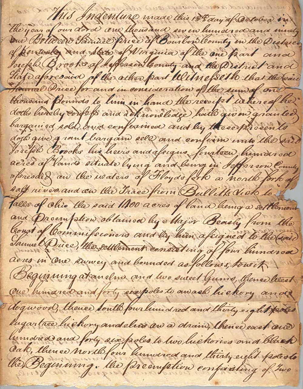
This indenture made this 13th day of October in the year of our Lord one thousand seven hundred and ninety one Between Samuel Price of Bourbon County in the District of Kentucky and State of Virginia of the one part and Joseph Brooks of Jefferson County and the District and State aforesaid of the other part. Witnesseth that the said Samuel Price for and in consideration of the sum of one thousand pounds to him in hand, the receipt whereof he doth hereby confess and acknowledge, hath given, granted, bargained, sold and confirmed and by these presents doth give, grant, bargain, sell and confirm unto the said Joseph Brooks, his heirs and assigns, fourteen hundred acres of land situate, lying and being in Jefferson County aforesaid on the waters of Floyd's fork, a north fork of Salt river and on the Trace from Bullitts Lick to falls of Ohio, the said 1400 acres of land being a settlement and preemption obtained by Major Beasly from the Court of Commissioners and by him assigned to the said Samuel Price, the settlement consisting of four hundred acres in one survey and bounded as follows, to wit.
Beginning at an elm and two sweet gums, thence West one hundred and forty six poles to an ash, hickory and dogwood, thence South four hundred and thirty eight poles sugar tree, hickory and elm on a drain, thence East one hundred and forty six poles to two hickories and black oak, thence North four hundred and thirty eight poles to the Beginning.
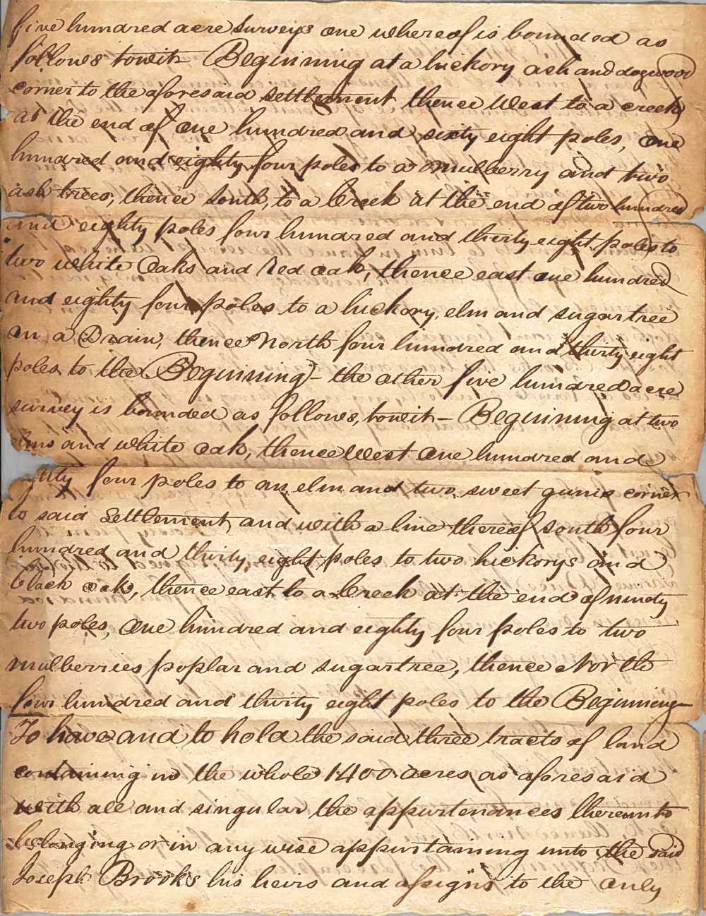
The preemption consisting of two five hundred acre surveys one whereof is bounded as follows, to wit.
Beginning at a hickory, ash and dogwood corner to the aforesaid settlement, thence West to a creek at the end of one hundred and sixty eight poles, one hundred and eighty four poles to a mulberry and two ash trees, thence South to a creek at the end of two hundred and eighty poles four hundred and thirty eight poles to two white oaks and red oak, thence East one hundred and eighty four poles to a hickory, elm and sugar tree on a drain, thence North four hundred and thirty eight poles to the Beginning.
The other five hundred acre survey is bounded as follows, to wit. Beginning at two elms and white oak, thence West one hundred and sixty four poles to an elm and two sweet gums corner to said settlement and with a line thereof South four hundred and thirty eight poles to two hickorys and black oaks, thence East to a creek at the end of ninety two poles, one hundred and eighty four poles to two mulberries, poplar and sugar tree, thence North four hundred and thirty eight poles to the Beginning.
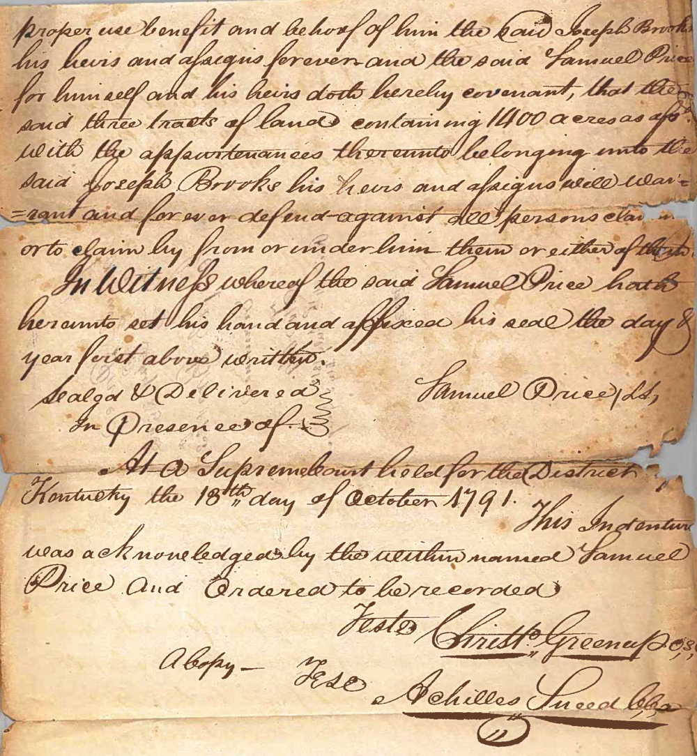
To have and to hold the said three tracts of land containing in the whole 1400 acres as aforesaid with all and singular the appurtenances thereunto belonging or in any wise appertaining unto the said Joseph Brooks, his heirs and assigns, to the only proper use, benefit and behoof of him the said Joseph Brooks his heirs and assigns forever and the said Samuel Price for himself and his heirs doth hereby covenant that the said three tracts of land containing 1400 acres as aforesaid, with the appurtenances thereunto belonging unto the said Joseph Brooks, his heirs and assigns will warrant and forever defend against all persons or to claim by from or under him, them or either of them.
In witness whereof the said Samuel Price hath hereunto set his hand and affixed his seal the day and year first above written.
(signed) Samuel Price
At a Supreme Court held for the District of Kentucky the 18th day of October 1791, this indenture was acknowledged by the within named Samuel Price and ordered to be recorded.
Teste: Christopher Greenup, C.S.C. A copy - teste: Achilles Sneed, clerk
If you, the reader, have an interest in any particular part of our county history, and wish to contribute to this effort, use the form on our Contact Us page to send us your comments about this, or any Bullitt County History page. We welcome your comments and suggestions. If you feel that we have misspoken at any point, please feel free to point this out to us.
The Bullitt County History Museum, a service of the Bullitt County Genealogical Society, is located in the county courthouse at 300 South Buckman Street (Highway 61) in Shepherdsville, Kentucky. The museum, along with its research room, is open 10 a.m. to 4 p.m. Monday through Friday. Saturday appointments are available by calling 502-921-0161 during our regular weekday hours. Admission is free. The museum, as part of the Bullitt County Genealogical Society, is a 501(c)3 tax exempt organization and is classified as a 509(a)2 public charity. Contributions and bequests are deductible under section 2055, 2106, or 2522 of the Internal Revenue Code. Page last modified: 04 Sep 2025 . Page URL: bullittcountyhistory.org/bchistory/price-brooks1400.html