
On 3 Aug 1795, Adam Shepherd surveyed a large tract lying on the waters of Wilson Creek, Long Lick Creek, Crooked Creek and Cane Run for Matthew Walton. The survey was founded on an entry made 21 Jan 1784. Shortly after the survey was completed, Walton signed it over to William Elzey Jr. who received a deed for the land on 28 Feb 1796.
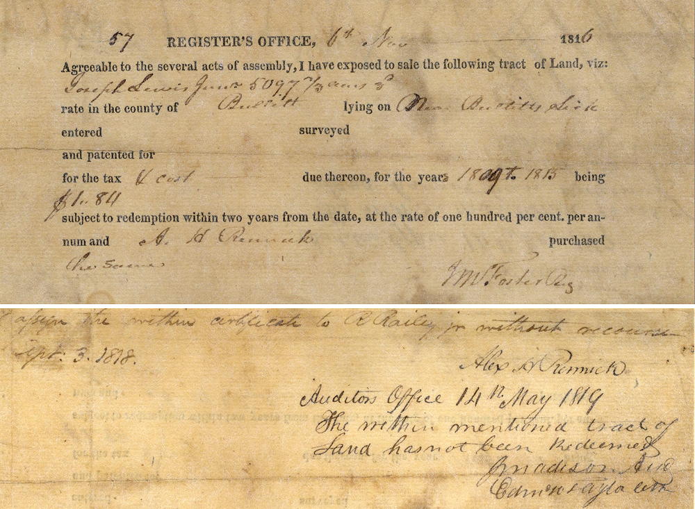
By November 1816, a major part of the tract (5097.67 acres) was in the hands of Joseph Lewis Jr. He had apparently failed to pay taxes on the land for at least six years, and the court ordered it sold for the back taxes. Randolph Railey was the purchaser, and he had it resurveyed, as shown below. He later sold it to John H. Baker.
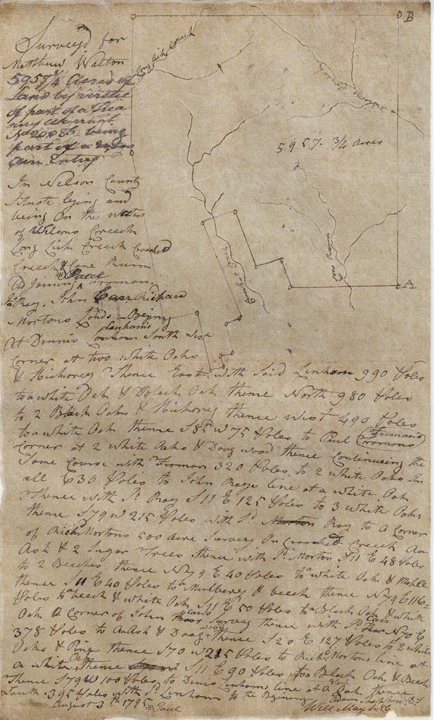
Matthew Walton Survey
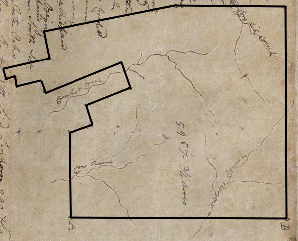
Surveyed for Matthew Walton, 5957 3/4 acres of land by virtue of part of a treasury warrant No. 20086, being part of a 20,000 acre entry in Nelson county situate, lying and being on the waters of Wilson Creek, Long Lick Creek, Crooked Creek and Cane Run, and joining Paul Froman, John Ray, John Carr, Richard Morton's lands. Beginning at Dennis Lenham's southwest corner at two white oaks and hickory, thence East with said Lenham 990 poles to a white oak and black oak, thence North 980 poles to 2 black oaks & hickory, thence West 490 poles to a white oak, thence S 85° W 75 poles to Paul Froman's corner at two white oaks and a dogwood, thence continuing the same course with Froman 320 poles to two white oaks, in all 630 poles to John Ray's line at a white oak, thence with said Ray S 11° E 125 poles to three white oaks, thence S 79° W 215 poles with said Ray to a corner of Richard Morton's 500 acre survey on Crooked Creek an ash and 2 sugar trees, thence with said Morton S 11° E 48 poles to 2 beeches, thence N 79° E 40 poles to a white oak and maple, thence S 11° E 40 poles to a mulberry and beech, thence N 79° E 116 poles to a beech and white oak, S 11° E 50 poles to a black oak and white oak, a corner of John Carr's survey, thence with said Carr N 70° E 378 poles to an ash and dogwood, thence S 20° E 127 poles to two white oaks and pine, thence S 70° W 215 poles to Richard Morton's line at a white oak, thence S 11° E 90 poles to a black oak and beech, thence S 79° W 100 poles to Dennis Lenham's line at a a black oak, thence South 395 poles with said Lenham's line to the beginning. August 3rd 1795; Adam Shepherd, surveyor
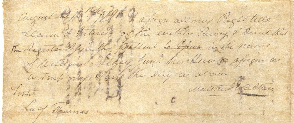
August 13th 1795. I assign all my right, title, claim and interest of the within survey and direct that the register issue the patent in the name of William Elzey Jr., his heirs or assigns as witness my hand the day as above. (signed) Matthew Walton; teste: Lacy Thomas
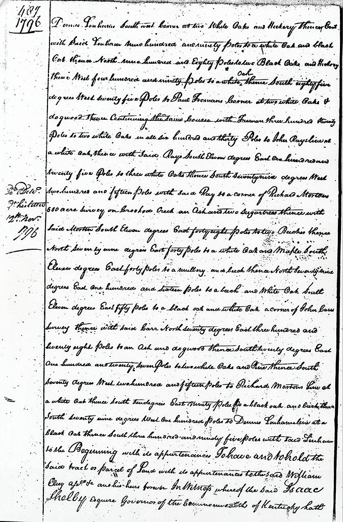
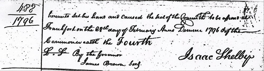
William Elzey Deed
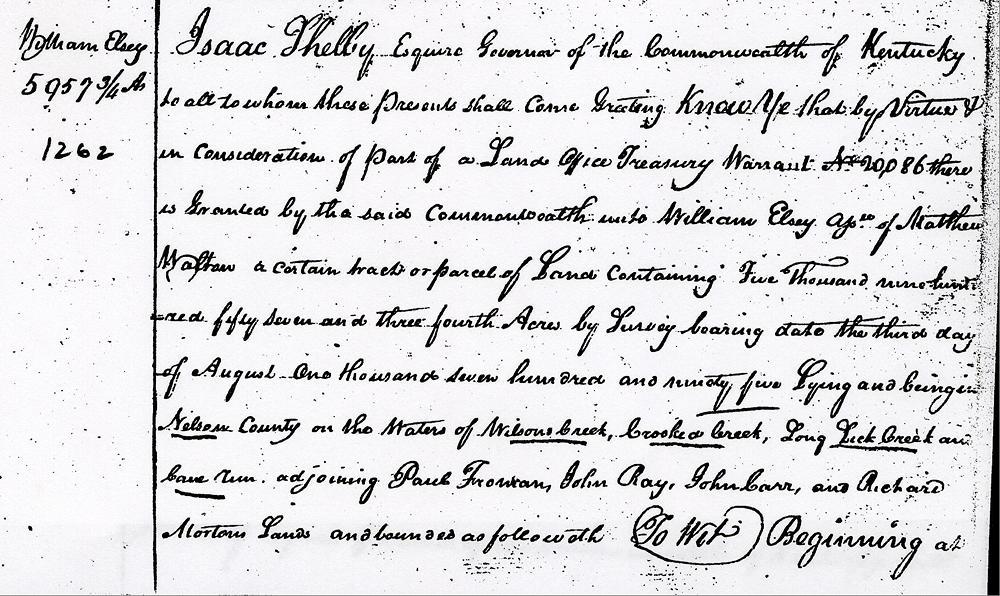
Isaac Shelby Equire, Governor of the Commonwealth of Kentucky, to all to whom these presents shall come, greeting. Know ye that by virtue and in consideration of part of a land office treasury warrant No. 20086 there is granted by the said Commonwealth unto William Elsey, assignee of Matthew Walton, a certain tract or parcel of land containing five thousand nine hundred and fifty seven and three fourth acres by survey bearing date the third day of August one thousand seven hundred and ninety five, lying and being in Nelson County on the waters of Wilsons Creek, Crooked Creek, Long Lick Creek and Cane Run adjoining Paul Froman, John Ray, John Carr, and Richard Morton's lands and bounded as followeth, to wit. Beginning at Dennis Lenham's southwest corner at two white oaks and hickory, thence East with said Lenham nine hundred and ninety poles to a white oak and black oak, thence North nine hundred and eighty poles to two black oaks & hickory, thence West four hundred and ninety poles to a white oak, thence South 85° West seventy five poles to Paul Froman's corner at two white oaks and dogwood, thence continuing the same course with Froman three hundred twenty poles to two white oaks, in all six hundred and thirty poles to John Ray's line at a white oak, thence with said Ray South 11° East one hundred andtwenty five poles to three white oaks, thence South 79° West two hundred and fifteen poles with said Ray to a corner of Richard Morton's 500 acre survey on Crooked Creek an ash and two sugar trees, thence with said Morton South 11° East 48 poles to two beeches, thence North 79° East 40 poles to a white oak and maple, South 11° East 40 poles to a mulberry and beech, thence North 79° East one hundred sixteen poles to a beech and white oak, South 11° East 50 poles to a black oak and white oak, a corner of John Carr's survey, thence with said Carr North 70° East three hundred and seventy eight poles to an ash and dogwood, thence South 20° East one hundred twenty seven poles to two white oaks and pine, thence South 70° West two hundred and fifteen poles to Richard Morton's line at a white oak, thence South 11° East 90 poles to a black oak and beech, thence South 79° West one hundred poles to Dennis Lenham's line at a black oak, thence South three hundred and ninety five poles with said Lenham's to the beginning with its appurtenances. To have and to hold the said tract or parcel of land with its appurtenances to the said William Elsey aforesaid &c and his heirs forever. In witness whereof the said Isaac Shelby Esquire, Governor of the Commonwealth of Kentucky hath hereunto set his hand and caused the seal of the Commonwealth to be affixed at Frankfort on the 28th day of February annon Dominio 1796 and of the Commonwealth the fourth. By the governor, Isaac Shelby; James Brown, secretary.
Tax Transfer
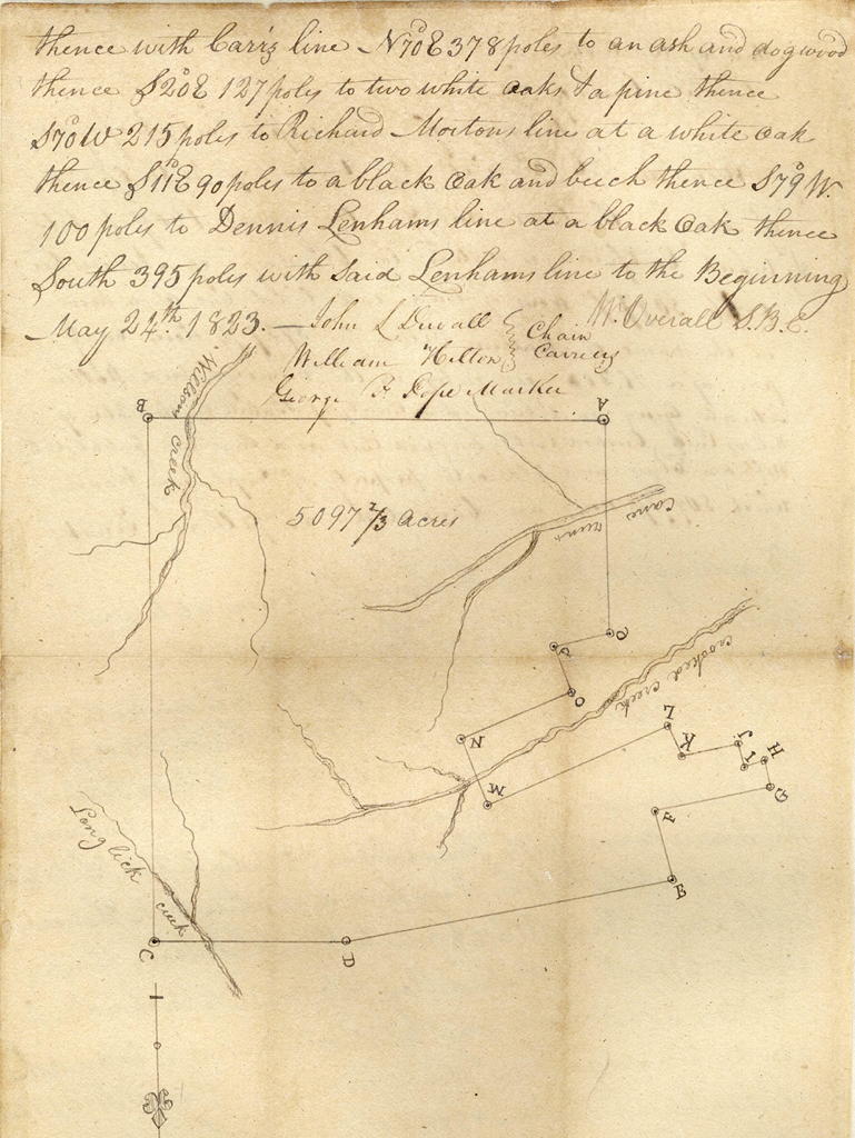
Randolph Railey Jr. Survey
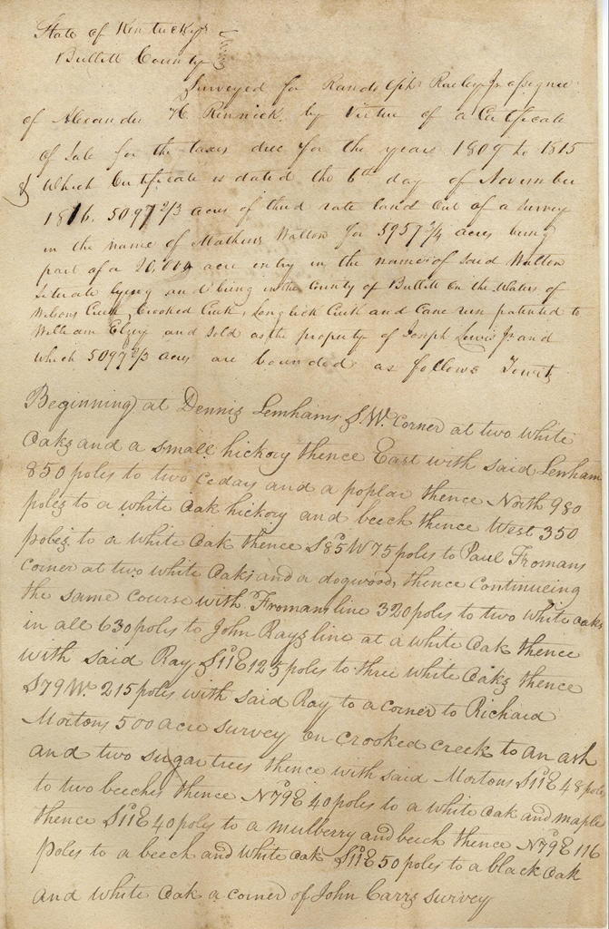
State of Kentucky, Bullitt County
Surveyed for Randolph Railey Jr., assignee of Alexander H. Rennick by virtue of a certificate of sale for the taxes due for the years 1809 to 1815 & which certificate is dated the 6th day of November, 1816, 5097 2/3 acres of third rate land out of a survey in the name of Mathew Walton for 5957 3/4 acres being part of a 20,000 acre entry in the name of said Walton, situate lying and being in the county of Bullitt on the waters of Wilson Creek, Crooked Creek, Long Lick Creek and Cane Run, patented to William Elzey and sold as the property of Joseph Lewis Jr. and which 5097 2/3 acres are bounded as follows, to wit.
Beginning at Dennis Lenham's S.W. corner at two white oaks and a small hickory, thence East with said Lenham 850 poles to two cedars and a poplar, thence North 980 poles to a white oak, hickory and beech, thence West 350 poles to a white oak, thence S 85° W 75 poles to Paul Froman's corner at two white oaks and a dogwood, thence continuing the same course with Froman's line 320 poles to two white oaks, in all 630 poles to John Ray's line at a white oak, thence with said Ray S 11° E 125 poles to three white oaks, thence S 79° W 215 poles with said Ray to a corner of Richard Morton's 500 acre survey on Crooked Creek to an ash and two sugar trees, thence with said Morton S 11° E 48 poles to two beeches, thence N 79° E 40 poles to a white oak and maple, thence S 11° E 40 poles to a mulberry and beech, thence N 79° E 116 poles to a beech and white oak, S 11° E 50 poles to a black oak and white oak, a corner of John Carr's survey, thence with Carr's line N 70° E 378 poles to an ash and dogwood, thence S 20° E 127 poles to two white oaks and a pine, thence S 70° W 215 poles to Richard Morton's line at a white oak thence S 11° E 90 poles to a black oak and beech, thence S 79° W 100 poles to Dennis Lenham's line at a a black oak, thence South 395 poles with said Lenham's line to the beginning. May 24th 1823. W. Overall, S.B.C.; John L. Duvall and William Hilton, chain carriers; George F. Pope, marker.
If you, the reader, have an interest in any particular part of our county history, and wish to contribute to this effort, use the form on our Contact Us page to send us your comments about this, or any Bullitt County History page. We welcome your comments and suggestions. If you feel that we have misspoken at any point, please feel free to point this out to us.
The Bullitt County History Museum, a service of the Bullitt County Genealogical Society, is located in the county courthouse at 300 South Buckman Street (Highway 61) in Shepherdsville, Kentucky. The museum, along with its research room, is open 10 a.m. to 4 p.m. Monday through Friday. Saturday appointments are available by calling 502-921-0161 during our regular weekday hours. Admission is free. The museum, as part of the Bullitt County Genealogical Society, is a 501(c)3 tax exempt organization and is classified as a 509(a)2 public charity. Contributions and bequests are deductible under section 2055, 2106, or 2522 of the Internal Revenue Code. Page last modified: 21 Apr 2026 . Page URL: bullittcountyhistory.org/bchistory/ok1262-elsey.html