
Following the death of Archibald Magruder, two of his daughters, with their husbands, brought suit in county court to have his land divided amongst his children. The court appointed three commissioners to go on the land and make a fair division for the six heirs. Their report to the court was recorded in the county will book. The part allotted to N. W. Gatten and wife is described below.
Bullitt County Deed Book Q, Pages 166-167
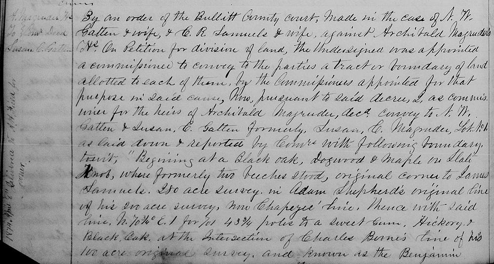
By an order of the Bullitt County Court made in the case of N. W. Gatten & wife & C. R. Samuels & wife against Archibald Magruder's heirs on petition for division of land, the undersigned was appointed a commissioner to convey to the parties the tract or boundary of land allotted to each of them by the commissioners appointed for that purpose in said cause.
Now pursuant to said decree I as commissioner for the heirs of Archibald Magruder dec'd convey to N. W. Gatten & Susan C. Gatten, formerly Susan C. Magruder, lot No. 1 as laid down & reported by commissioners with following boundary, to wit:
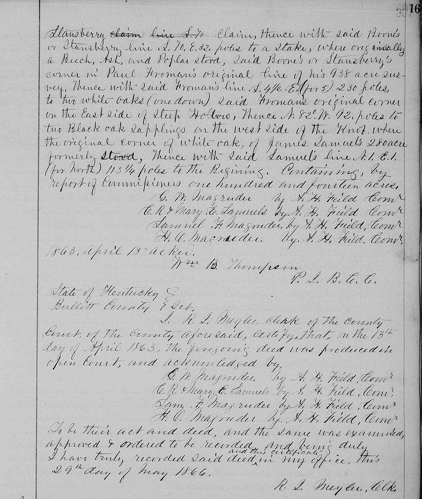
Beginning at a black oak, dogwood & maple on Slate Knob, where formerly two beeches stood, original corner to James Samuels' 280 acre survey in Adam Shepherd's original line of his 200 acre survey, now Chapeze's line, thence with said line N 70 3/4° for 71° E 43 3/4 poles to a sweet gum, hickory & black oak at the intersection of Charles Boone's line of his 100 acre original survey and known as the Benjamin Stansbury claim, thence with said Boone's or Stansbury line S 70° E 32 poles to a stake, where originally a beech, ash and poplar stood, said Boone's or Stansbury's corner in Paul Froman's original line of his 938 acres survey thence with said Froman's line S 4 1/2° (for 5°) 230 poles to two white oaks (one down) said Froman's original corner on the east side of steep hollow, thence N 82° W 92 poles to two black oak sapplings on the west side of the knob where the original corner of white oak of James Samuels' 280 acre formerly stood, thence with said Samuels' line N 1° E 1° (for north)113 1/4 poles to the beginning containing by report of commissioners one hundred and fourteen acres.
(Signed 13 Apr 1863 by A. H. Field, commissioner for G. W. Magruder, C. R. & Mary E. Samuels, Samuel F. Magruder and H. O. Magruder.)
If you, the reader, have an interest in any particular part of our county history, and wish to contribute to this effort, use the form on our Contact Us page to send us your comments about this, or any Bullitt County History page. We welcome your comments and suggestions. If you feel that we have misspoken at any point, please feel free to point this out to us.
The Bullitt County History Museum, a service of the Bullitt County Genealogical Society, is located in the county courthouse at 300 South Buckman Street (Highway 61) in Shepherdsville, Kentucky. The museum, along with its research room, is open 10 a.m. to 4 p.m. Monday through Friday. Saturday appointments are available by calling 502-921-0161 during our regular weekday hours. Admission is free. The museum, as part of the Bullitt County Genealogical Society, is a 501(c)3 tax exempt organization and is classified as a 509(a)2 public charity. Contributions and bequests are deductible under section 2055, 2106, or 2522 of the Internal Revenue Code. Page last modified: 30 Mar 2026 . Page URL: bullittcountyhistory.org/bchistory/magruderheirs-gatten.html