
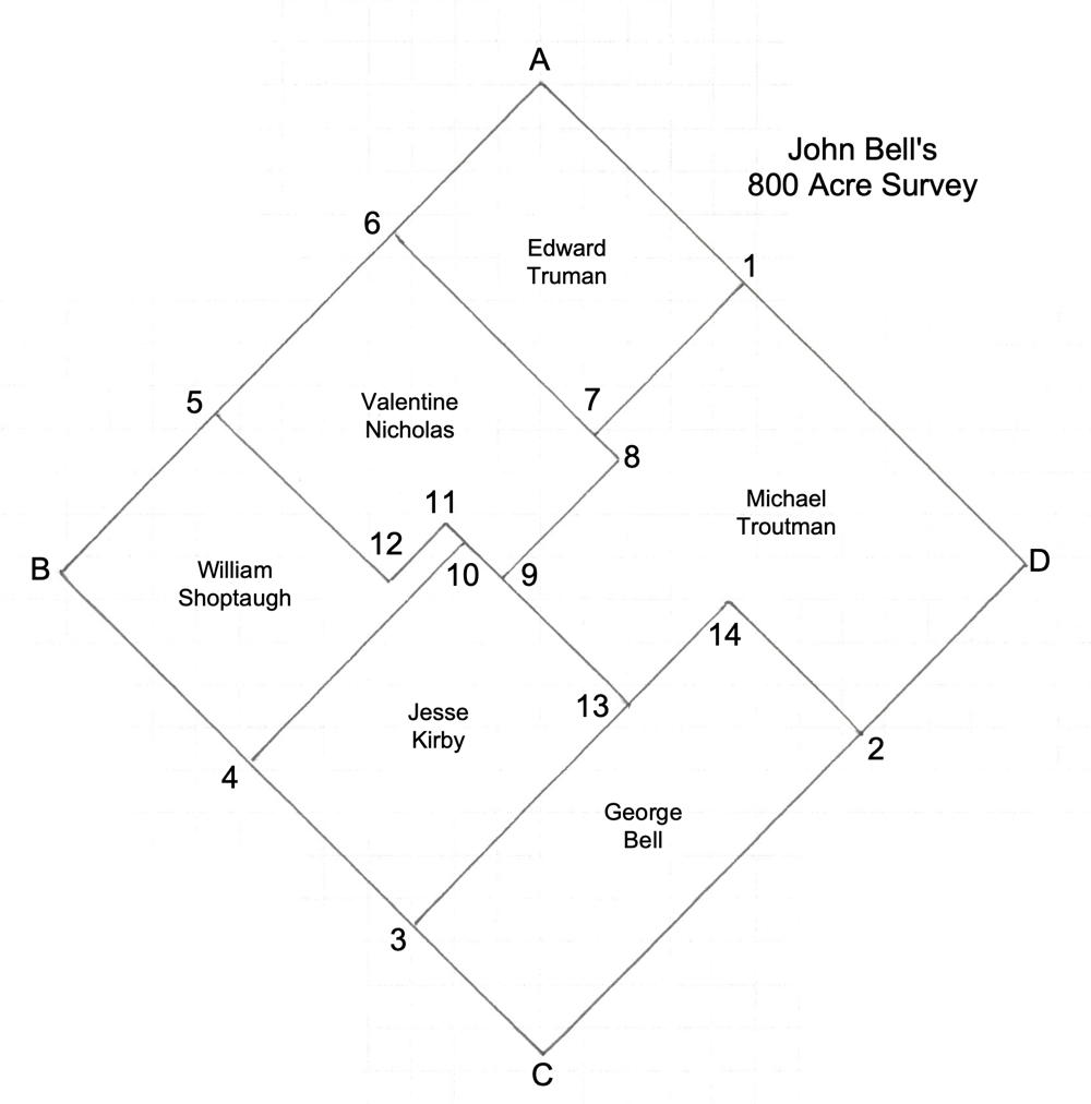
On 24 Oct 1797, John Bell sold the first part of his 800 acre survey to Edward Truman. This survey was located west of the West Fork of Cox's Creek in Bullitt County. The divisions of the 800 acre survey are shown here.
Truman's tract began at Bell's northern corner [A] of two gums, a sugar tree and poplar. It extended southwest 108 poles to [6] a gum and two dogwoods; then turned southeast 149 poles to [7] a maple and sugar tree. It then turned northeast 108 poles to [1], a poplar and dogwood in Bell's line, before turning northwest 149 poles to the beginning.
A transcription of this deed, and an image of it both appear below.
You may read more about John Bell's survey, and about the deeds of the remaining purchasers by following these links.
Bullitt County Deed Book A2, page 33
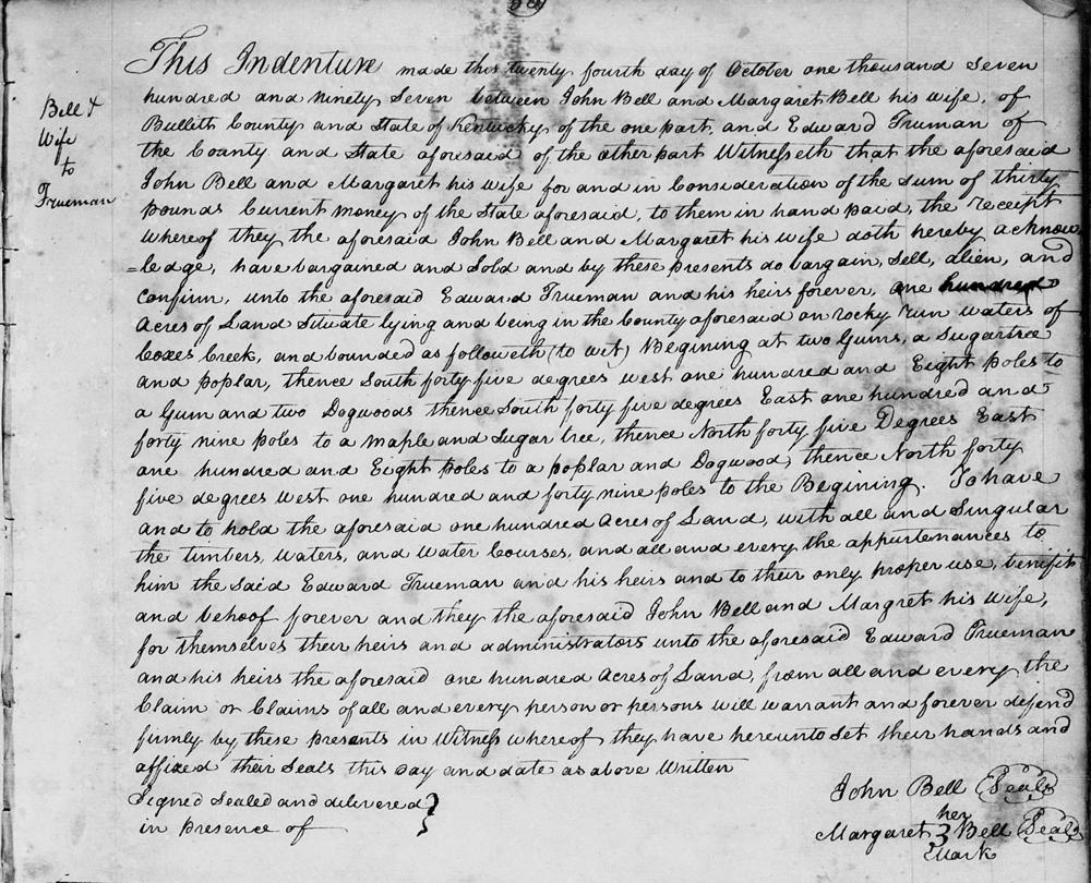
This indenture made the twenty fourth day of October one thousand seven hundred and ninety seven between John Bell and Margaret Bell his wife of Bullitt County and State of Kentucky of the one part, and Edward Truman of the county and state aforesaid of the other part, witnesseth that the aforesaid John Bell and Margaret his wife for and in consideration of the sum of thirty pounds current money of the state aforesaid to them in hand paid the receipt whereof they the aforesaid John Bell and Margaret his wife doth hereby acknowledge, have bargained and sold and by these presents do bargain, sell, alien, and confirm, unto the aforesaid Edward Trueman and his heirs forever, one hundred acres of land situate lying and being in the county aforesaid on Rocky Run waters of Cox's Creek, and bounded as followeth (to wit) Beginning at two gums, a sugar tree and poplar, thence South forty five degrees West one hundred and eight poles to a gum and two dogwoods, thence South forty five degrees East one hundred and forty nine poles to a maple and sugar tree, thence North forty five degrees East one hundred and eight poles to a poplar and dogwood, thence North forty five degrees West one hundred and forty nine poles to the beginning. To have and to hold the aforesaid one hundred acres of land with all and singular the timbers, waters, and water courses, and all and every the appurtenances to him the said Edward Trueman and his heirs and to their only proper use, benefit and behoof forever and they the aforesaid John Bell and Margaret his wife, for themselves, their heirs and administrators unto the aforesaid Edward Trueman and his heirs the aforesaid one hundred acres of land from all and every the claim or claims of all and every person or persons will warrant and forever defend firmly by these presents. In witness whereof they have hereunto set their hands and affixed their seals this day and date as above written. (signed) John Bell, Margaret (her X mark) Bell.
If you, the reader, have an interest in any particular part of our county history, and wish to contribute to this effort, use the form on our Contact Us page to send us your comments about this, or any Bullitt County History page. We welcome your comments and suggestions. If you feel that we have misspoken at any point, please feel free to point this out to us.
The Bullitt County History Museum, a service of the Bullitt County Genealogical Society, is located in the county courthouse at 300 South Buckman Street (Highway 61) in Shepherdsville, Kentucky. The museum, along with its research room, is open 10 a.m. to 4 p.m. Monday through Friday. Saturday appointments are available by calling 502-921-0161 during our regular weekday hours. Admission is free. The museum, as part of the Bullitt County Genealogical Society, is a 501(c)3 tax exempt organization and is classified as a 509(a)2 public charity. Contributions and bequests are deductible under section 2055, 2106, or 2522 of the Internal Revenue Code. Page last modified: 04 Sep 2025 . Page URL: bullittcountyhistory.org/bchistory/johnbell-edwardtruman.html