
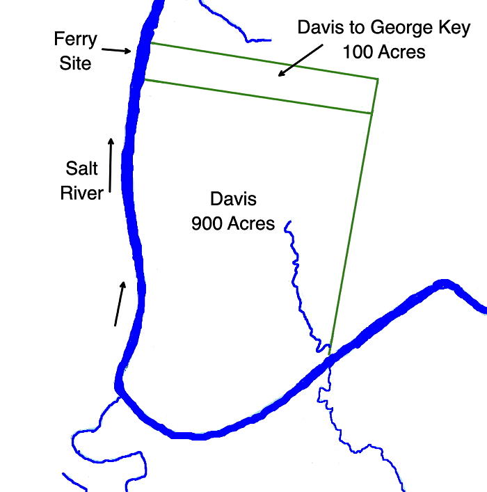
Thomas Davis deeded 100 acres of his 900 acre survey to George L. Key. Key established a ferry across Salt River at this location. The transcribed text gives the tract description. A map at the bottom of this page shows where we think it was located.
Bullitt County Deed Book C, pages 268-9
This indenture made this 11th day of September in the year of our Lord 1813 between Thomas Davis of the county of Lincoln and state of Kentucky of the one part and George L. Key of the county of Bullitt and state aforesaid of the other part.
Witness that the said Thomas Davis for and in consideration of the good will and affection which the said Thomas Davis bears to the said George L. Key, doth give, grant and by these presents doth give, grant and confirm unto the said George L. Key, his heirs, executors or assigns a certain tract or parcel of land lying and being in the county of Bullitt and state aforesaid on Salt River containing by survey 100 acres, it being a part of a tract of land of 900 acres entered in the name of Robert Davis and surveyed and patented in the name of the said Thomas Davis bearing date the 6th day of November 1787, and bounded as followeth viz.
Beginning at two maples on the bank of Salt River, thence S 82° E 318 poles to a beech and white oak, thence S 10° W 51 poles to a beech and dogwood, corner to John Tuly's 100 acres of the aforesaid 900 acres, thence N 82° W 318 poles to a maple, ash and sycamore with the said Tuly's line, thence down with the meanders of the said river to the beginning.
To have and to hold the aforesaid tract or parcel of land and premises together with its appurtenances unto the said George L. Key, his heirs and assigns forever. And the said Thomas Davis, for himself, his heirs, executors and administrators doth and will warrant and forever defend by these presents. In witness whereof I the said Thomas Davis have hereunto set my hand and seal the day and year above written. (signed) Thomas Davis.
Signed, sealed and delivered in the presence of John Davis, George D. Key, John Tuey, Thomas Key.
Bullitt County Sct
I James Halbert, Clerk of the County Court in and for the county aforesaid, do certify that on this day the foregoing indenture was acknowledged in my presence by Thomas Davis a party thereto to be his act and deed for the purposes therein mentioned. Whereupon I have truly recorded the same together with this certificate in my said office. Given under my hand this 20 day of February 1826. (signed) James Halbert
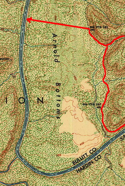
This clip of a topographic map on the right was taken from a 1946 Fort Knox map which showed with dotted lines the remains of older dirt roads. We have highlighted the one we think led to Key's Ferry.
If you, the reader, have an interest in any particular part of our county history, and wish to contribute to this effort, use the form on our Contact Us page to send us your comments about this, or any Bullitt County History page. We welcome your comments and suggestions. If you feel that we have misspoken at any point, please feel free to point this out to us.
The Bullitt County History Museum, a service of the Bullitt County Genealogical Society, is located in the county courthouse at 300 South Buckman Street (Highway 61) in Shepherdsville, Kentucky. The museum, along with its research room, is open 10 a.m. to 4 p.m. Monday through Friday. Saturday appointments are available by calling 502-921-0161 during our regular weekday hours. Admission is free. The museum, as part of the Bullitt County Genealogical Society, is a 501(c)3 tax exempt organization and is classified as a 509(a)2 public charity. Contributions and bequests are deductible under section 2055, 2106, or 2522 of the Internal Revenue Code. Page last modified: 26 Oct 2026 . Page URL: bullittcountyhistory.org/bchistory/davis-key.html
