
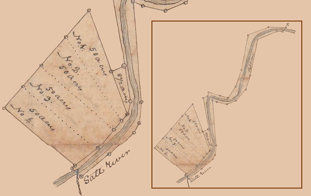
In a decree of the Bullitt Circuit Court in the case of William Congrove and wife against Jonathan Iron's heirs to divide the lands belonging to the heirs, commissioners were appointed including George F. Pope, Abraham Field and Whitledge Overall, the county surveyor. Their report and Overall's survey plat have been located in the T.C. Carroll plats [247-10a & 247-10b]. In the plat drawing below, the full plat is shown as an insert on the right with the 4 lots shown in a larger scale on the left. We have transcribed this document below the plat drawing.
Deeds were then made to Benjamin & Nancy Jewell, James Guthrie and Isaac Froman. The 160 acre tract, including the bed and banks of Salt River, were purchased by Jonathan Iron from Adam Shepherd.
Commissioners' Report
State of Kentucky. We the undersigned commissioners appointed by a decree of the Bullitt Circuit Court in the case of William Congrove and wife against Jonathan Iron's heirs to divide the lands belonging to said heirs, do report that we have laid off the tracts lying on the north side of Salt River and that which includes the bed of the river and its banks which appears by the foregoing plat; and by agreement of the heirs and those concerned Isaac Froman took Lot No. 4 on being paid whatever sum of money the commissioners should think proper. In laying off the tracts of land the commissioners had to lay it off in equal parts so that each share should run to the river, but in lying off the shares Lot No. 3 included a valuable orchard and the commissioners believed that the said lot was worth $32 more than the others, and agreed that said Froman who had purchased the interest of Sarah Mulligan in said tracts should be paid the sum of $8 by the other heirs. On the 27th day of October 1827 we met for the purpose of allotting to the heirs the other three shares and concluded that said heirs should draw for the same. George F. Pope, one of the commissioners drew for Isaac Froman who had purchased from William Congrove and wife their interest in said land. Benjamin Jewell drew for himself and wife, and Thomas Q. Willson attended for James Guthrie. Said Pope drew for Froman Lot No. 3; Benjamin Jewell Lot No. 2; and the remaining ticket was for said Guthrie so that said Froman wil have to pay to Jewell and Guthrie the sums of $8 each.
The tract represented on this plat containing 160 acres including the banks and bed of Salt River, and the old salt well from its situation we could not divide. We went on to a tract containing 552 acres lying on Long Lick Creek and surveyed the same and then ran division lines so as to throw it into four parts so that each share should take in a part of Long Lick Creek and its bottoms, but after running the lines and examining the land we are of opinion that said tract cannot be equitably divided so that each heir shall have an equal part of the good ... land. We are informed that there is another tract of land in this county on the south side of Salt River, but there being no title papers furnished us we did not examine the said tract preparatory to an attempt to divide the same. For what we have done we refer to the annexed plats, all of which is respectfully submitted. Witness our hands and seals this 27th day of October 1827. (signed) George F. Pope, Abraham Field
Surveyor's Report
Notes of explanation: the 160 acres includes the bed and banks of Salt [River] from the mouth of Long Lick Creek up to Christian's corner of his 1000 acre survey at No. 8, and includes the old salt well.
The courses and distance of the 50 acres in Lot No. 1 - Beginning at a large elm on the bank of Salt River, it being Iron's corner, thence down the river and binding thereon 14 poles to three elms, thence North 44° West 190 poles to four ironwoods from one root, thence North 30° East 62 poles to two white oaks and a hickory, thence South 31° East 110 poles to a stone in the original line, thence North 53° East 25 poles to the bank of Salt River, thence down the river and binding thereon to the beginning.
The courses and distance of the 50 acres in Lot No. 2 - Beginning at three Elms on the Bank of Salt River, thence down the river South 37° West 24 poles to a stake and two small elms, thence North 60° West 160 poles to three hickories, thence North 30° East 74 poles to four ironwoods from one root, thence South 44° East 190 poles to the beginning.
Courses and distances of the 50 acres in Lot No. 3 - Beginning at a stake and two small elms on the bank of Salt River, thence North 60° West 160 poles to three small hickories, thence South 38° West 50 poles to a stake near a small elm, thence South 60° East 160 poles to 3 elms on the bank of Salt River, thence up the river 50 poles to the beginning.
The courses and distances of the 50 acres in Lot No. 4 - Beginning at three elms on the bank of Salt River and running thence North 60° West 160 poles to a stake near a small elm, thence South 30° West 50 poles to a stone near Froman's fence, one of the original corners, thence South 60° East 160 poles to two hickories and a walnut on the bank of Salt River, thence up Salt River and binding thereon 50 poles to the beginning.
October the 10th 1827. W. Overall, S.B.C.
If you, the reader, have an interest in any particular part of our county history, and wish to contribute to this effort, use the form on our Contact Us page to send us your comments about this, or any Bullitt County History page. We welcome your comments and suggestions. If you feel that we have misspoken at any point, please feel free to point this out to us.
The Bullitt County History Museum, a service of the Bullitt County Genealogical Society, is located in the county courthouse at 300 South Buckman Street (Highway 61) in Shepherdsville, Kentucky. The museum, along with its research room, is open 10 a.m. to 4 p.m. Monday through Friday. Saturday appointments are available by calling 502-921-0161 during our regular weekday hours. Admission is free. The museum, as part of the Bullitt County Genealogical Society, is a 501(c)3 tax exempt organization and is classified as a 509(a)2 public charity. Contributions and bequests are deductible under section 2055, 2106, or 2522 of the Internal Revenue Code. Page last modified: 11 Nov 2026 . Page URL: bullittcountyhistory.org/bchistory/congrove-irons-report.html
