
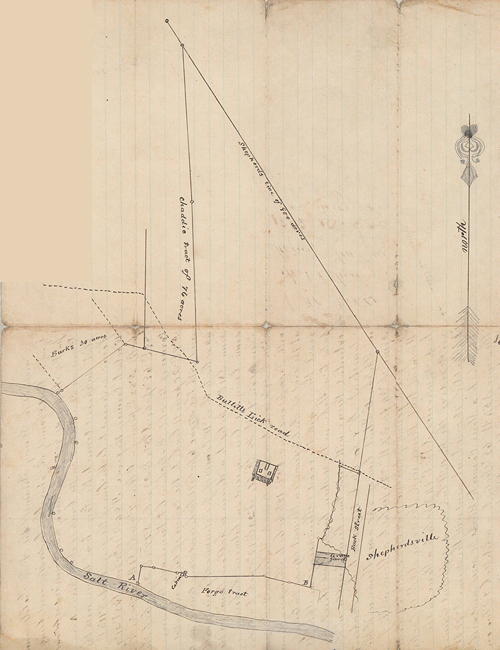
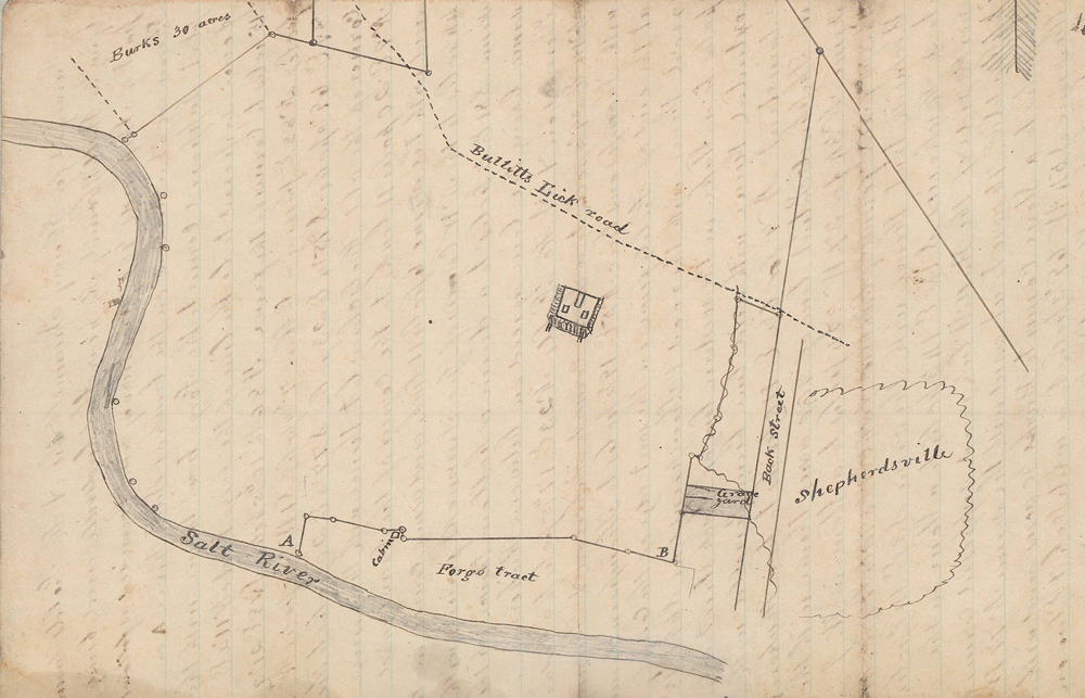
On 20 Dec 1882, Henry Trunnell, who had obtained this tract, had Casper Herps survey it. Shown to the right is Herps' plat drawing for this survey. A larger view of the lower section is presented below. Trunnell then sold the tract to W. T. Lee on 13 Oct 1888.
Surveyed for Henry Trunnell the A. H. Field farm lying in Bullitt County, Kentucky near Shepherdsville, and being part of Shepherd's 900 acre survey, and bounded as follows.
Beginning at a willow on the bank of Salt River, A on plat, supposed corner to the forge tract, thence with the fence, supposed to be the line of the forge tract, North 11 1/2° East 15 poles to corner of the fence, South 86° East 10 4/5 poles, South 78° East 21 1/3 poles, North 88° East, passing a cabin 7 3/4 poles, South 1° West 3 3/5 poles, North 89° East 69 1/4 poles, South 75 1/4° East 23 poles, South 77 1/4° East 20 poles to the corner of the old Holsclaw lot, thence with the same North 9° East 20 poles 11 links to the corner of the graveyard and with the same 6 poles 11 links and same course in all 44 poles to the northwest corner of George Simmons' fence, and with same South 81° East 3 poles to a drain or hollow, thence up the same, being the line agreed on between Rickerson, Thompson and A. H. Field, North 23° East 17 4/5 poles to a cedar, North 14° East 29 1/2 poles to a stone, corner to Rickerson and Thompson, with Thompson's line North 5° East 19 1/2 poles to Thompson's corner at the end of Field's fence on the west edge of the county road, thence with the road and Thompson's line South 69° East 18 poles to a stake in the western line of Back Street when extended, thence with said line being parallel with Main Street North 9° for 6 1/2° East 110 poles to two hickories in Shepherd's patent line of 900 acres, thence with the same North 34° for 37° West 324 poles to a stone in W. J. Phelps' field, formerly Chaddic's field, and corner to the old Beckwith tract, thence with the same South 3° East 140 poles to 2 hickories, South 1 1/2° East 143 poles to a stone on the north side of the Bullitt Lick road, supposed corner to Chaddic's 76 acre tract, and with the same North 77° West 66 poles to a stone, corner to Burks' 30 acres, and with the same South 54° West 69 1/3 poles to a white oak and elm on the bank Salt River, Burks' corner, and same course 6 poles to low water mark, thence up Salt River with its meanders to low water mark to the beginning, containing 448 acres.
August 1882, C. Herps, Surveyor, B.C.
If you, the reader, have an interest in any particular part of our county history, and wish to contribute to this effort, use the form on our Contact Us page to send us your comments about this, or any Bullitt County History page. We welcome your comments and suggestions. If you feel that we have misspoken at any point, please feel free to point this out to us.
The Bullitt County History Museum, a service of the Bullitt County Genealogical Society, is located in the county courthouse at 300 South Buckman Street (Highway 61) in Shepherdsville, Kentucky. The museum, along with its research room, is open 10 a.m. to 4 p.m. Monday through Friday. Saturday appointments are available by calling 502-921-0161 during our regular weekday hours. Admission is free. The museum, as part of the Bullitt County Genealogical Society, is a 501(c)3 tax exempt organization and is classified as a 509(a)2 public charity. Contributions and bequests are deductible under section 2055, 2106, or 2522 of the Internal Revenue Code. Page last modified: 18 Sep 2026 . Page URL: bullittcountyhistory.org/bchistory/ahfield-plat.html
