
On 16 Jul 1787, Robert Breckinridge surveyed 10,200 acres of land for William Fleming located in Jefferson County between Cedar Creek and Floyd's Fork. The survey may have included a bit of the future northern Bullitt County, but lay almost entirely in Jefferson.
There appears to have been a conflict concerning the actual location of the tract. In 1815, Fleming was still trying to clear up the conflict when he posted the following advertisement in the Kentucky Gazette.
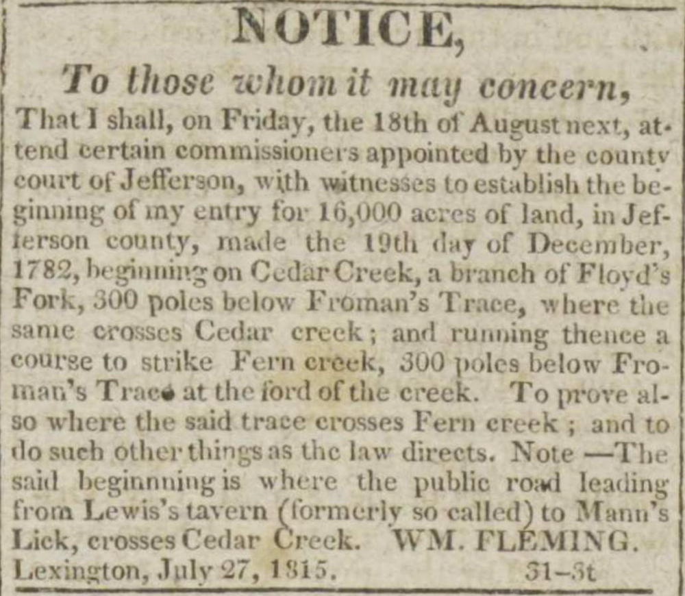
NOTICE
To those whom it may concern,
That I shall on Friday, the 18th of August next, attend certain commissioners appointed by the county court of Jefferson, with witnesses to establish the beginning of my entry for 16,000 acres of land, in Jefferson county, made the 19th day of December, 1782, beginning on Cedar Creek, a branch of Floyd's Fork, 300 poles below Froman's Trace, where the same crosses Cedar Creek; and running thence a course to strike Fern creek, 300 poles below Froman's Trace at the ford of the creek. To prove also where the said trace crosses Fern creek; and to do such other things as the law directs. Note – The said beginning is where the public road leading from Lewis's tavern (formerly so called) to Mann's Lick, crosses Cedar Creek. Wm. Fleming. Lexington, July 27, 1815.
Published in the Kentucky Gazette on 7 Aug 1815.
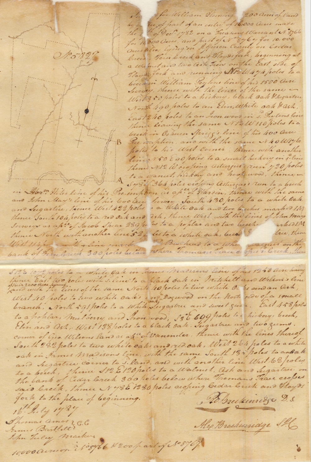
Fleming's survey and deed are shown below with their transcriptions.
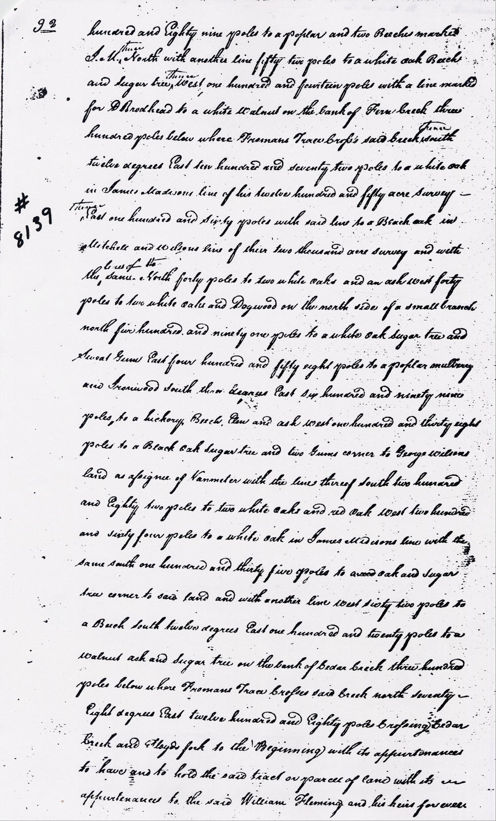
Survey
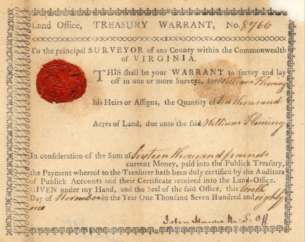
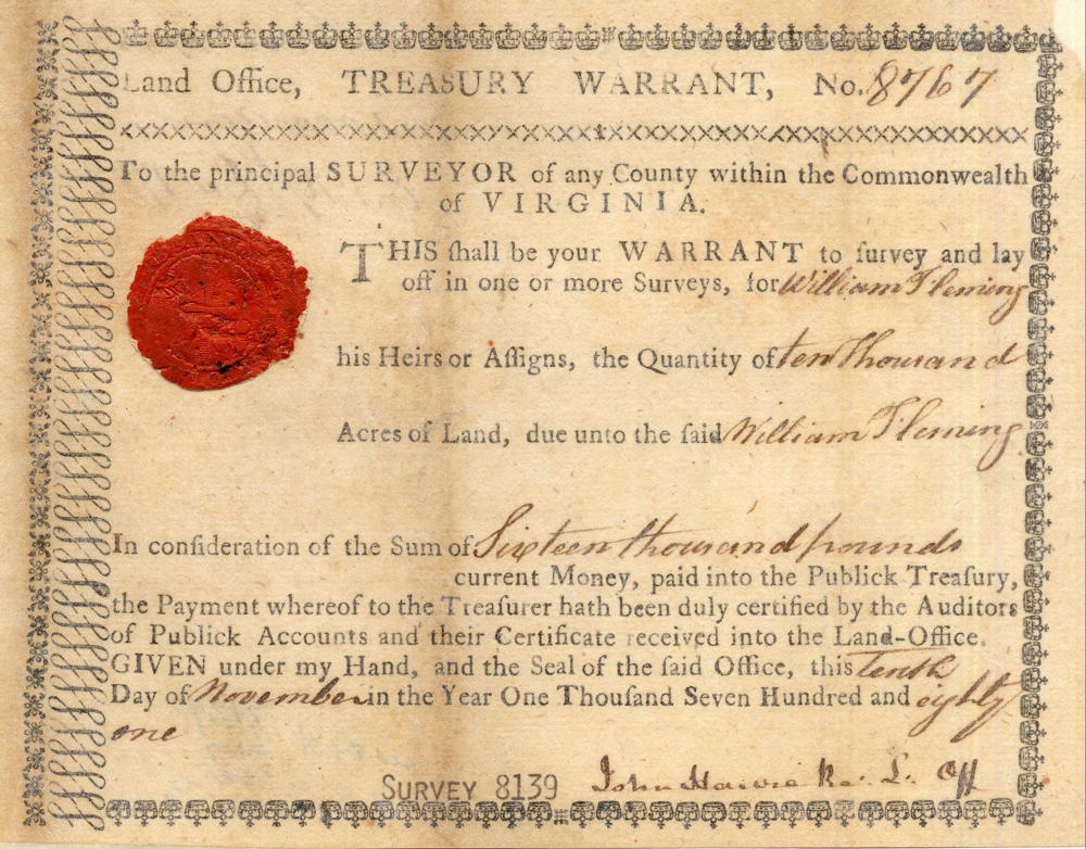
Surveyed for William Fleming 10,200 acres of land by virtue of part of an entry of 16,000 acres made the 19th day of December 1782 on a treasury warrant No. 8766 for 10,000 acres and part of No. 8767 for 10,000 acres also, lying in Jefferson County on Cedar Creek, Fern Creek and Floyd's Fork, beginning at a walnut and two ash trees on the East side of Floyd's Fork and running North 12° West 474 poles to a beech in William Peyton's line of his 1500 acre survey, thence with the line of the same West 350 poles to hickory, black oak and sugar tree, North 490 poles to an elm, white oak and ash, East 240 poles to an ironwood in said Peyton's line, thence leaving the same North 12° West 110 poles to a beech in Osburn Sprigg's line of his 400 acre preemption and with the same North 40° West 176 poles to his west corner, thence with another line North 50° East 90 poles to a small hickory in said line, thence North 12° West crossing Asturgus's run 720 poles to a walnut, hickory and hoopwood, thence South 78° West 364 poles crossing Asturgus's run to a beech in Abraham Hite's line of his preemption as assignee of Harden, thence with the same and John May's line of his 600 acre survey South 430 poles to a white oak and sugar tree, thence West 422 poles to a white oak and two beeches marked J.M., thence South 104 poles to a red oak and ash, thence West with the lines of John May's survey as assignee of Jacob Spear 289 poles to a poplar and two beeches marked J.M., thence North with another line 52 poles to a white oak, beech and sugar tree, thence West 114 poles with a line marked for D. Brodhead to a white walnut on the bank of Fern Creek 300 poles below where Froman's Trace crosses said creek, thence South 12° East 1072 poles to a white oak in James Madison's line of his 1250 acre survey, thence East 160 poles with said line to a black oak in Mitchell and Wilson's line of their 2000 acre survey and with the line of the same North 40 poles to two white oaks and an ash, West 40 poles to two white oaks and a dogwood on the north side of a small branch, North 591 poles to a white oak, sugar tree and sweet gum, East 458 poles to a poplar, mulberry and ironwood, South 3° East 699 poles to a hickory, beech, elm and ash, West 138 poles to a black oak, sugar tree and two gums corner of George Wilson's land as assignee of Vanmeter, thence with the lines thereof South 282 poles to two white oaks and red oak, West 264 poles to a white oak in James Madison's line, with the same South 135 poles to a red oak and sugar tree corner to said land and with another line West 62 poles to a beech, thence South 12° East 120 poles to a walnut, ash and sugar tree on the bank of Cedar Creek 300 poles below where Froman's Trace crosses said creek, thence North 78° East 1280 poles crossing Cedar Creek and Floyd's Fork to the place of beginning. 16th July 1787. Robert Breckinridge, Assistant Surveyor. Thomas Amos & James Bartlett, chain carriers. John Tuley, marker.
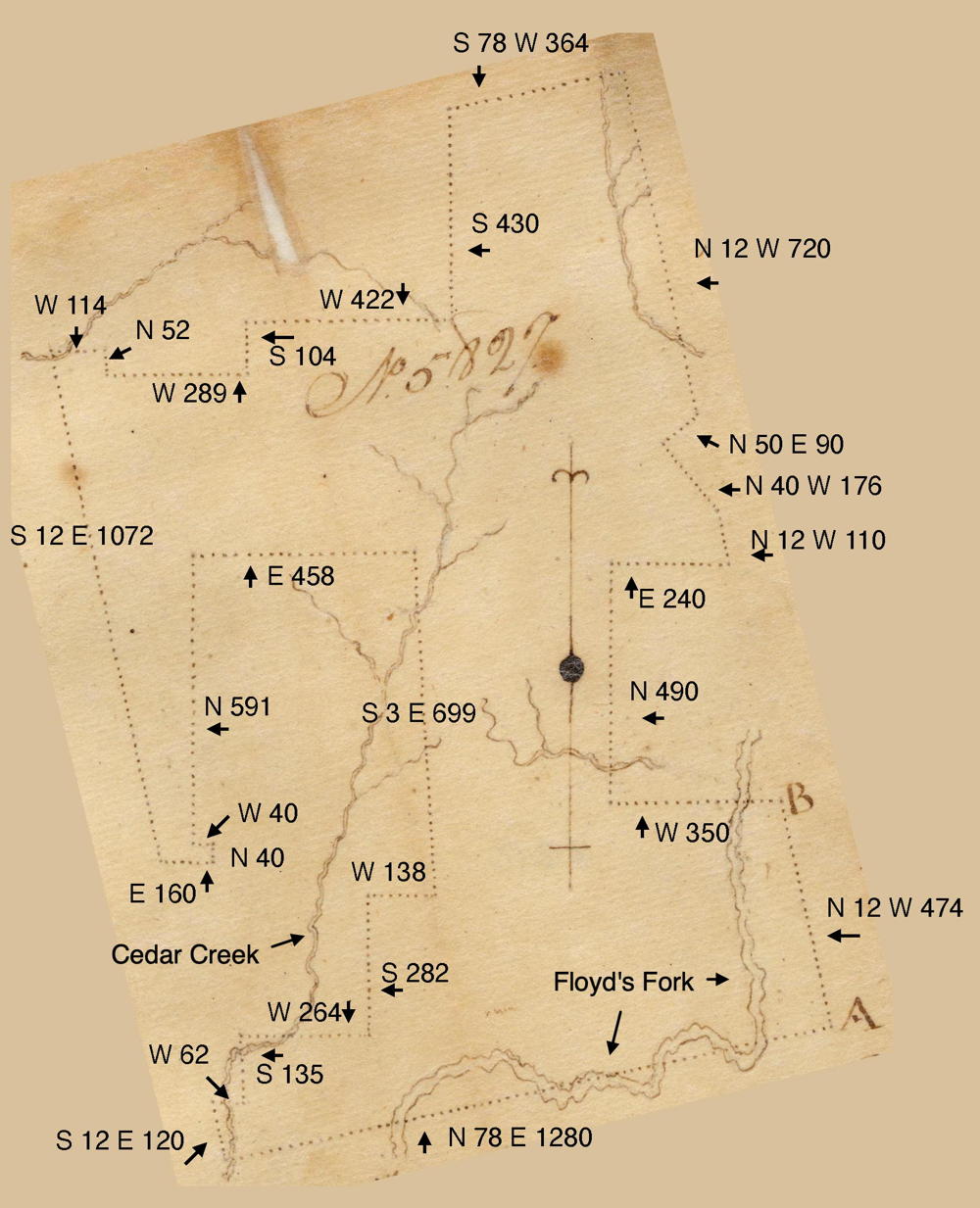
Survey Drawing
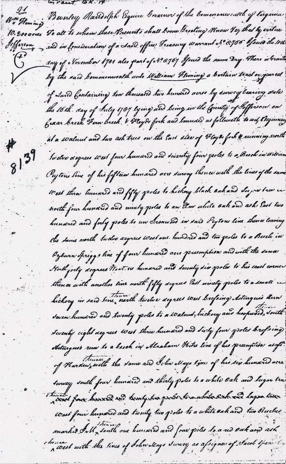
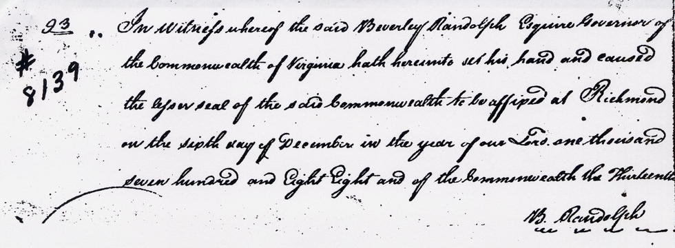
Deed
Virginia Grant Book 14, pages 91-93
Beverly Randolph Esquire, Governor of the Commonwealth of Virginia, to all to whom these presents shall come, greeting. Know ye that by virtue and in consideration of a land office treasury warrant number 8766 issued the 10th day of November 1781, also part of number 8767 issued the same day, there is granted by the said Commonwealth unto William Fleming a certain tract or parcel of land containing 10,200 acres by survey bearing date the 16th day of July 1787, lying and being in the county of Jefferson on Cedar Creek, Fern Creek & Floyd's Fork and bounded as followeth, to wit. Beginning at a walnut and two ash trees on the East side of Floyd's Fork and running North 12° West 474 poles to a beech in William Peyton's line of his 1500 acre survey, thence with the line of the same West 350 poles to hickory, black oak and sugar tree, North 490 poles to an elm, white oak and ash, East 240 poles to an ironwood in said Peyton's line, thence leaving the same North 12° West 110 poles to a beech in Osburn Sprigg's line of his 400 acre preemption and with the same North 40° West 176 poles to his west corner, thence with another line North 50° East 90 poles to a small hickory in said line, thence North 12° West crossing Asturgus's run 720 poles to a walnut, hickory and hoopwood, thence South 78° West 364 poles crossing Asturgus's run to a beech in Abraham Hite's line of his preemption as assignee of Harden, thence with the same and John May's line of his 600 acre survey South 430 poles to a white oak and sugar tree, thence West 422 poles to a white oak and two beeches marked J.M., thence South 104 poles to a red oak and ash, thence West with the lines of John May's survey as assignee of Jacob Spear 289 poles to a poplar and two beeches marked J.M., thence North with another line 52 poles to a white oak, beech and sugar tree, thence West 114 poles with a line marked for D. Brodhead to a white walnut on the bank of Fern Creek 300 poles below where Froman's Trace crosses said creek, thence South 12° East 1072 poles to a white oak in James Madison's line of his 1250 acre survey, thence East 160 poles with said line to a black oak in Mitchell and Wilson's line of their 2000 acre survey and with the line of the same North 40 poles to two white oaks and an ash, West 40 poles to two white oaks and a dogwood on the north side of a small branch, North 591 poles to a white oak, sugar tree and sweet gum, East 458 poles to a poplar, mulberry and ironwood, South 3° East 699 poles to a hickory, beech, elm and ash, West 138 poles to a black oak, sugar tree and two gums corner of George Wilson's land as assignee of Vanmeter, thence with the lines thereof South 282 poles to two white oaks and red oak, West 264 poles to a white oak in James Madison's line, with the same South 135 poles to a red oak and sugar tree corner to said land and with another line West 62 poles to a beech, thence South 12° East 120 poles to a walnut, ash and sugar tree on the bank of Cedar Creek 300 poles below where Froman's Trace crosses said creek, thence North 78° East 1280 poles crossing Cedar Creek and Floyd's Fork to the place of beginning with its appurtenances to have and to hold the said tract or parcel of land with its appurtenances to the said William Fleming and his heirs forever. In witness whereof the said Beverly Randolph Esquire, Governor of the Commonwealth of Virginia, hath hereunto set his hand and caused the lesser seal of the said Commonwealth to be affixed at Richmond on the sixth day of December in the year of our Lord 1788, and of the Commonwealth the 13th. (signed) B. Randolph
Warrants
If you, the reader, have an interest in any particular part of our county history, and wish to contribute to this effort, use the form on our Contact Us page to send us your comments about this, or any Bullitt County History page. We welcome your comments and suggestions. If you feel that we have misspoken at any point, please feel free to point this out to us.
The Bullitt County History Museum, a service of the Bullitt County Genealogical Society, is located in the county courthouse at 300 South Buckman Street (Highway 61) in Shepherdsville, Kentucky. The museum, along with its research room, is open 10 a.m. to 4 p.m. Monday through Friday. Saturday appointments are available by calling 502-921-0161 during our regular weekday hours. Admission is free. The museum, as part of the Bullitt County Genealogical Society, is a 501(c)3 tax exempt organization and is classified as a 509(a)2 public charity. Contributions and bequests are deductible under section 2055, 2106, or 2522 of the Internal Revenue Code. Page last modified: 12 Apr 2026 . Page URL: bullittcountyhistory.org/bchistory/8139-fleming.html