
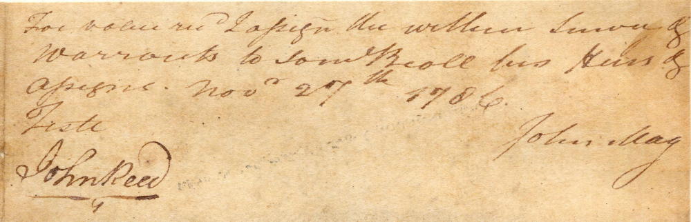
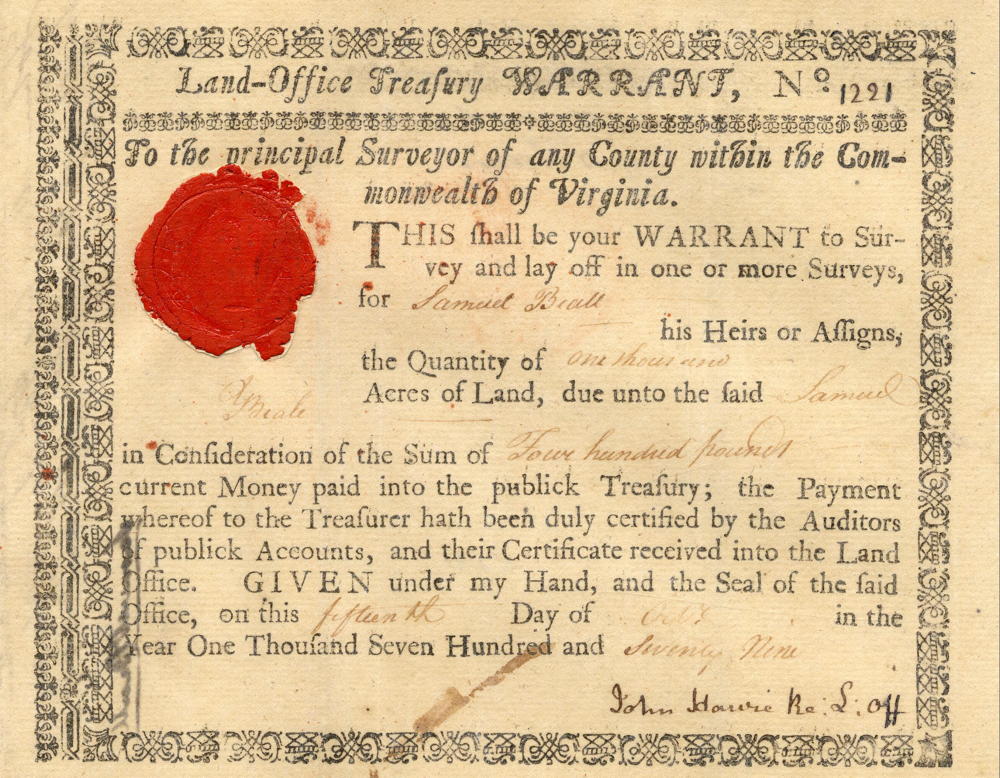
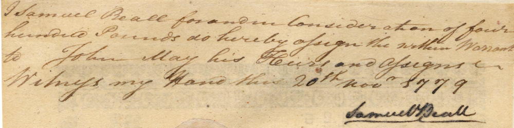
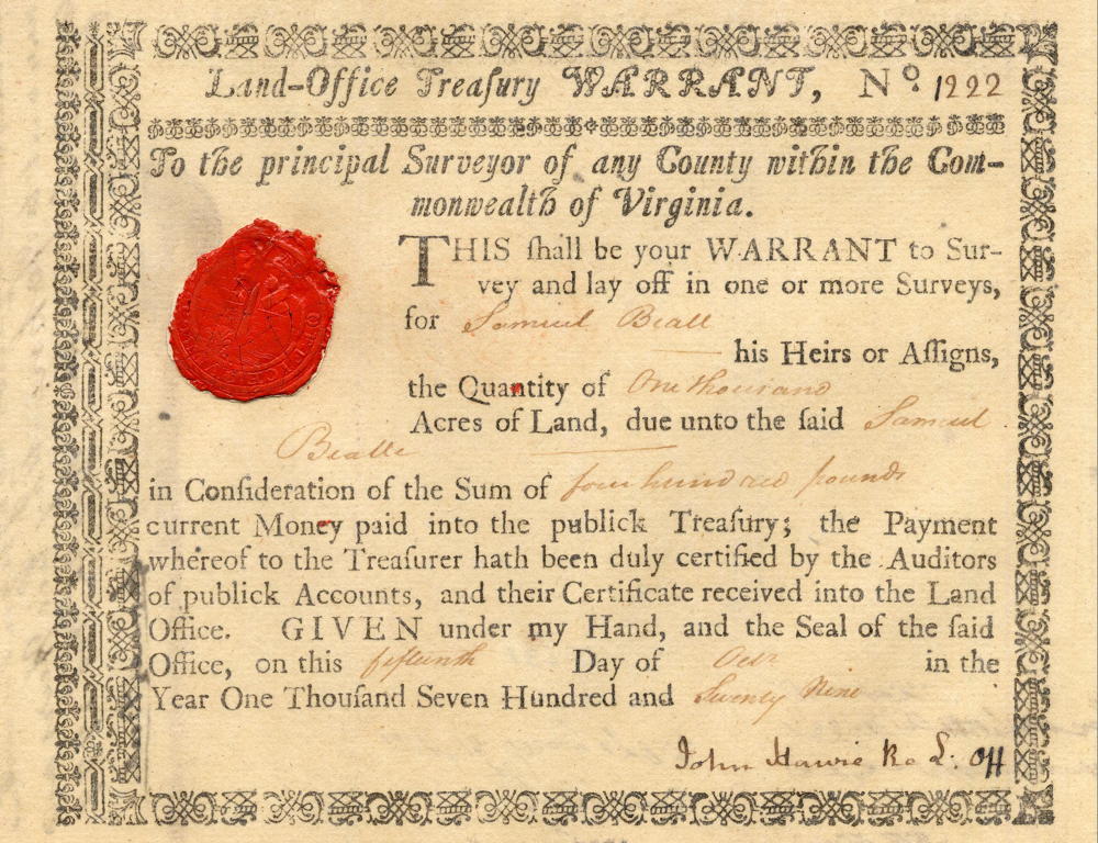
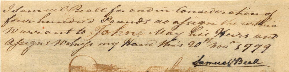
On 20 Nov 1779, Samuel Beall signed over two treasury warrants to John May, each for 1000 acres in exchange for a cash payment of 800 pounds. John May then used the warrants to have Robert Breckinridge survey 2000 acres for him on 4 Nov 1786 along the north side of Salt River from near Pond Creek up to the Rolling Fork. Then, less than a month later, on November 27th, May assigned the tract over to Samuel Beall "for value received." Beall then obtained a deed on the land on 13 Nov 1787. Later in 1835, this tract became the property of Samuel's descendant Norborne B. Beall.
The drawing below shows Breckinridge's sketch of the tract, together with some brief annotations. Images of the treasury warrants are located at the bottom of this page.
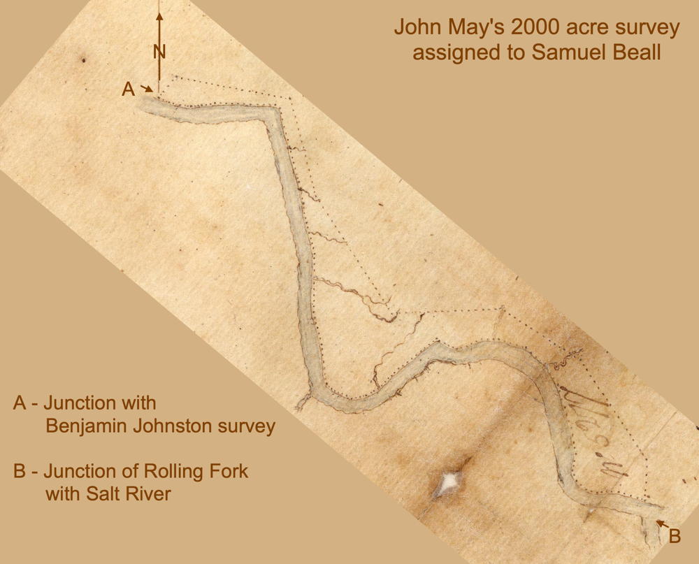
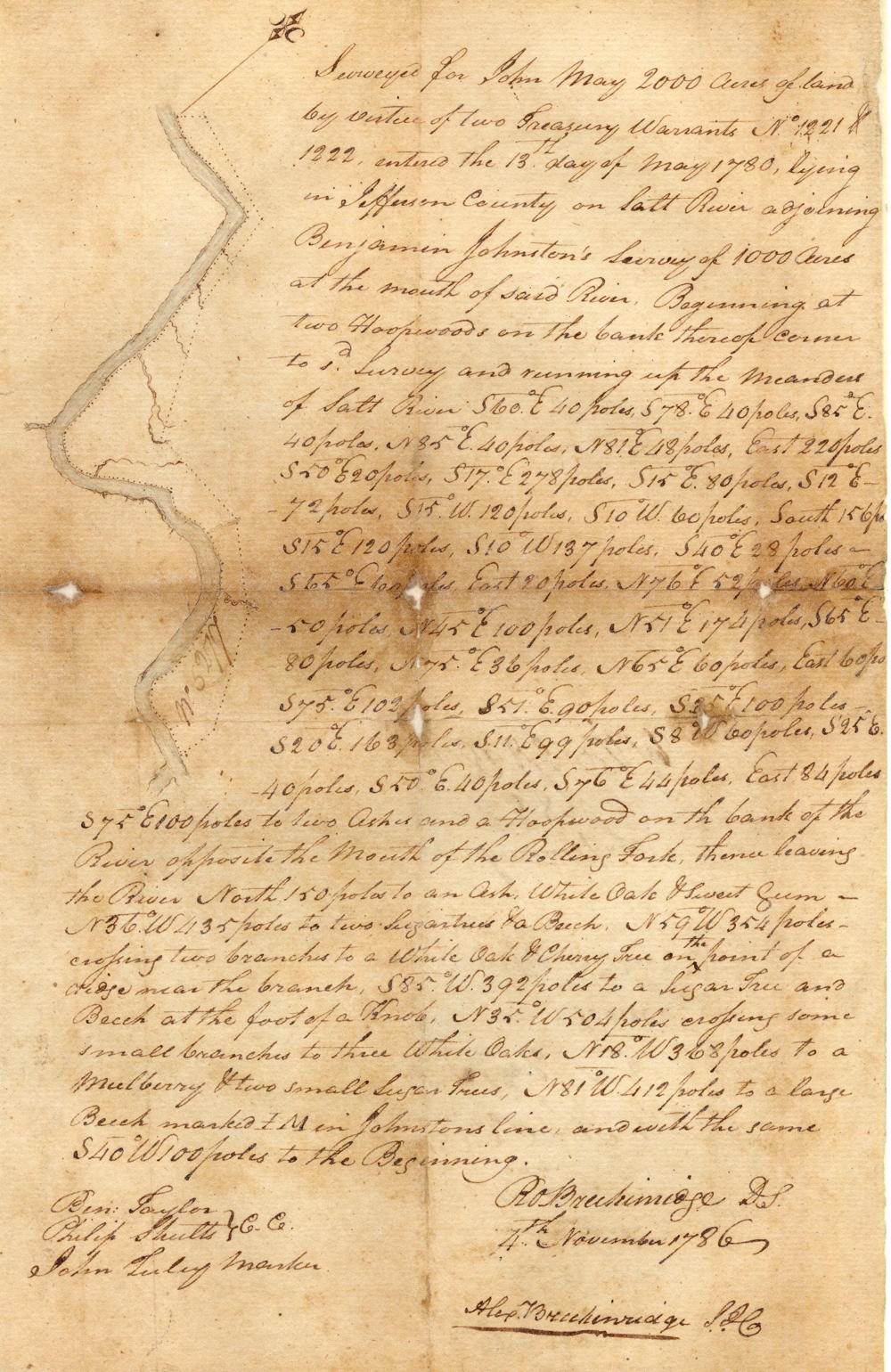
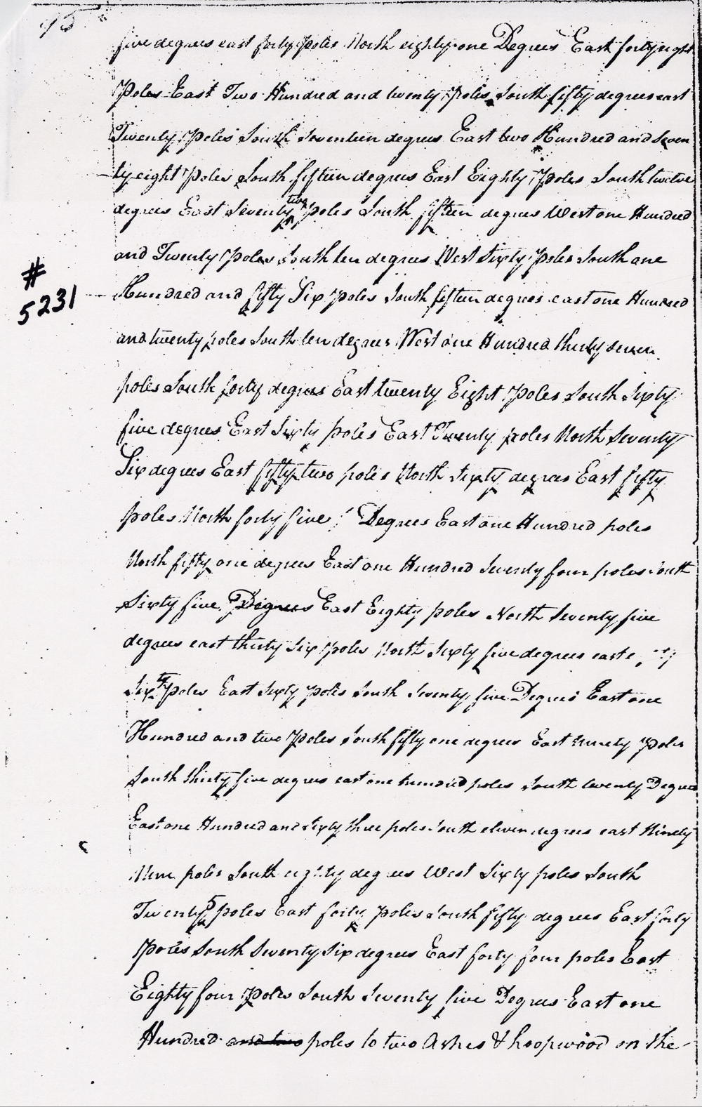
Survey
Surveyed for John May 2000 acres of land by virtue of two treasury warrants number 1221 and 1222, entered the 13th day of May 1780, lying in Jefferson County on Salt River adjoining Benjamin Johnston's survey of 1000 acres at the mouth of said river. Beginning at two hoopwoods on the bank thereof corner to said survey and running up the meanders of Salt River, S 60° E 40 poles, S 78° E 40 poles, S 85° E 40 poles, N 85° E 40 poles, N 81° E 48 poles, East 220 poles, S 50° E 20 poles, S 17° E 278 poles, S 15° E 80 poles, S 12° E 72 poles, S 15° W 120 poles, S 10° W 60 poles, South 156 poles, S 15° E 120 poles, S 10° W 137 poles, S 40° E 28 poles, S 65° E 100 poles, East 20 poles, N 76° E 52 poles, N 60° E 50 poles, N 45° E 100 poles, N 51° E 174 poles, S 65° E 80 poles, N 75° E 36 poles, N 65° E 60 poles, East 60 poles, S 75° E 102 poles, S 51° E 90 poles, S 35° E 100 poles, S 20° E 163 poles, S 11° E 99 poles, S 8° W 60 poles, S 25° E 40 poles, S 50° E 40 poles, S 76° E 44 poles, East 84 poles, S 75° E 100 poles to two ashes and a hoopwood on the bank of the river opposite the mouth of the Rolling Fork, thence leaving the river North 150 poles to an ash, white oak & sweet gum, N 36° W 435 poles to two sugar trees & a beech, N 59° W 354 poles crossing two branches to a white oak & cherry tree on the point of a ridge near the branch, S 85° W 392 poles to a sugar tree and beech at the foot of a knob, N 35° W 504 poles corssing some small branches to three white oaks, N 18° W 368 poles to a mulberry & two small sugar trees, N 81° W 412 poles to a large beech marked I.M. in Johnston's line and with the same S 40° W 100 poles to the beginning. Robert Breckinridge, surveyor. 4th November 1786. Ben Taylor & Philip Shults, chain carriers. John Tuley, marker.
Deed
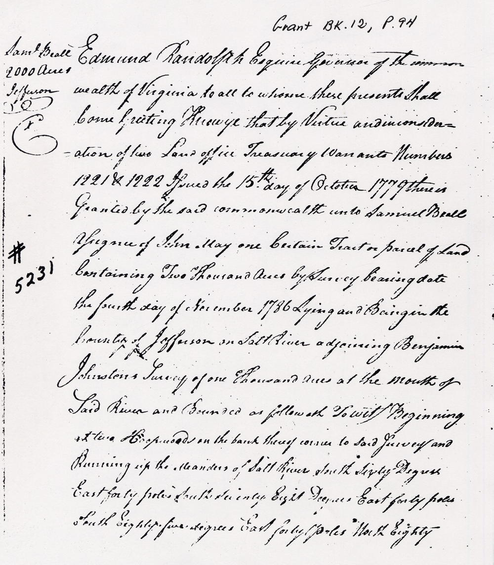
Virginia Grant Book 12, pages 94-97
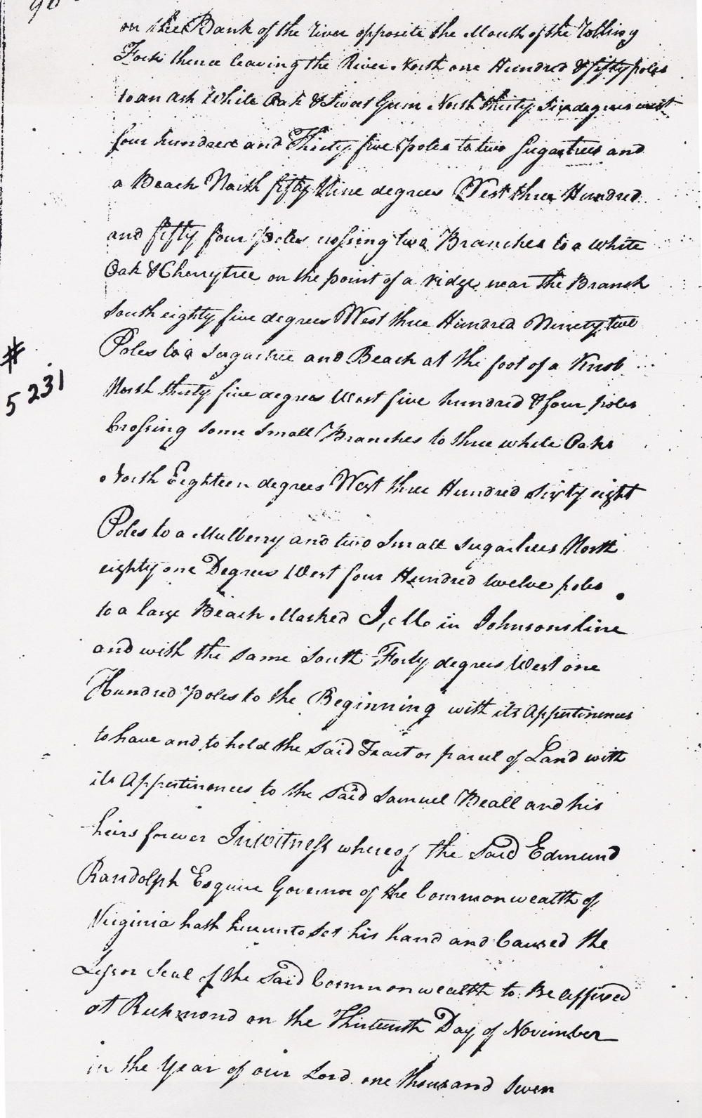
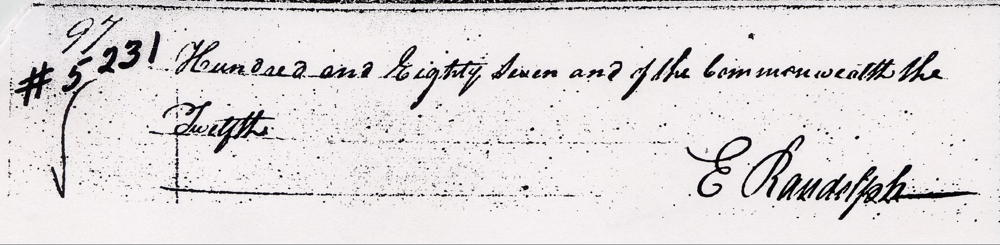
Edmund Randolph Esquire, governor of the Commonwealth of Virginia, to all to whom these presents shall come, greeting. Know ye that by virtue and in consideration of two land office treasury warrant numbers 1221 and 1222 issued the 15th day of October 1779, there is granted by the said Commonwealth unto Samuel Beall, assignee of John May, one certain tract or parcel of land containing 2000 acres by survey bearing date the fourth day of November 1786, lying and being in the county of Jefferson on Salt River adjoining Benjamin Johnston's survey of 1000 acres at the mouth of said river, and bounded as followeth, to wit. Beginning at two hoopwoods on the bank thereof corner to said survey and running up the meanders of Salt River, South 60° East 40 poles, South 78° East 40 poles, South 85° East 40 poles, North 85° East 40 poles, North 81° East 48 poles, East 220 poles, South 50° East 20 poles, South 17° East 278 poles, South 15° East 80 poles, South 12° East 72 poles, South 15° West 120 poles, South 10° West 60 poles, South 156 poles, South 15° East 120 poles, South 10° West 137 poles, South 40° East 28 poles, South 65° East 100 poles, East 20 poles, North 76° East 52 poles, North 60° East 50 poles, North 45° East 100 poles, North 51° East 174 poles, South 65° East 80 poles, North 75° East 36 poles, North 65° East 60 poles, East 60 poles, South 75° East 102 poles, South 51° East 90 poles, South 35° East 100 poles, South 20° East 163 poles, South 11° East 99 poles, South 8° West 60 poles, South 25° East 40 poles, South 50° East 40 poles, South 76° East 44 poles, East 84 poles, South 75° East 100 poles, to two ashes and a hoopwood on the bank of the river opposite the mouth of the Rolling Fork, thence leaving the river North 150 poles to an ash, white oak & sweet gum, N 36° W 435 poles to two sugar trees & a beech, N 59° W 354 poles crossing two branches to a white oak & cherry tree on the point of a ridge near the branch, S 85° W 392 poles to a sugar tree and beech at the foot of a knob, N 35° W 504 poles corssing some small branches to three white oaks, N 18° W 368 poles to a mulberry & two small sugar trees, N 81° W 412 poles to a large beech marked I.M. in Johnston's line and with the same S 40° W 100 poles to the beginning with its appurtenances to have and to hold the said tract or parcel of land with its appurtenances to the said Samuel Beall and his heirs forever. In witness whereof the said Edmund Randolph Esquire, Governor of the Commonwealth of Virginia, hath hereunto set his hand and caused the lesser seal of the said Commonwealth to be affixed at Richmond on the 13th day of November in the year of our Lord 1787, and of the Commonwealth the 12th. (signed) E. Randolph
Warrants
If you, the reader, have an interest in any particular part of our county history, and wish to contribute to this effort, use the form on our Contact Us page to send us your comments about this, or any Bullitt County History page. We welcome your comments and suggestions. If you feel that we have misspoken at any point, please feel free to point this out to us.
The Bullitt County History Museum, a service of the Bullitt County Genealogical Society, is located in the county courthouse at 300 South Buckman Street (Highway 61) in Shepherdsville, Kentucky. The museum, along with its research room, is open 10 a.m. to 4 p.m. Monday through Friday. Saturday appointments are available by calling 502-921-0161 during our regular weekday hours. Admission is free. The museum, as part of the Bullitt County Genealogical Society, is a 501(c)3 tax exempt organization and is classified as a 509(a)2 public charity. Contributions and bequests are deductible under section 2055, 2106, or 2522 of the Internal Revenue Code. Page last modified: 21 Apr 2026 . Page URL: bullittcountyhistory.org/bchistory/5231-beall.html