
On 21 Feb 1783, Alexander Breckenridge surveyed 1250 acres of land for Rev. James Madison located in Jefferson County between Cedar Creek and Floyd's Fork. Much of this land was also included in a survey completed by George Wilson for Simon Triplett. This 1250 acre survey and deed are described below.
Survey
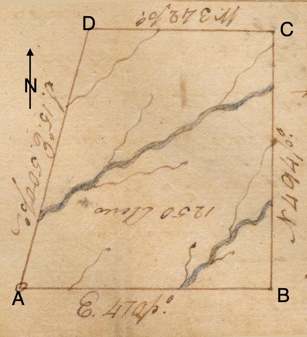
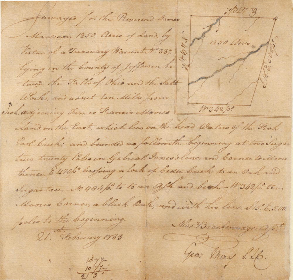
Surveyed for the Reverend James Madison 1250 acres of land by virtue of a treasury warrant No. 337 lying in the county of Jefferson between the Falls of Ohio and the salt works and about 10 miles from each adjoining James Francis Moore’s land on the east which lies on the headwaters of the Fish Pool Creek and bounded as followeth. Beginning at two sugars trees 20 poles in Gabrial Jones’ line and corner to Moore, thence East 470 poles crossing a fork of Cedar Creek to an oak and sugar tree, North 494 poles to an ash and beech, West 342 poles to Moore’s corner, a black oak, and with his line South 15° East 500 poles to the beginning. 21st of February 1783. Alexander Breckenridge surveyor
Deed
Virginia Grant Book 1, pages 363-364
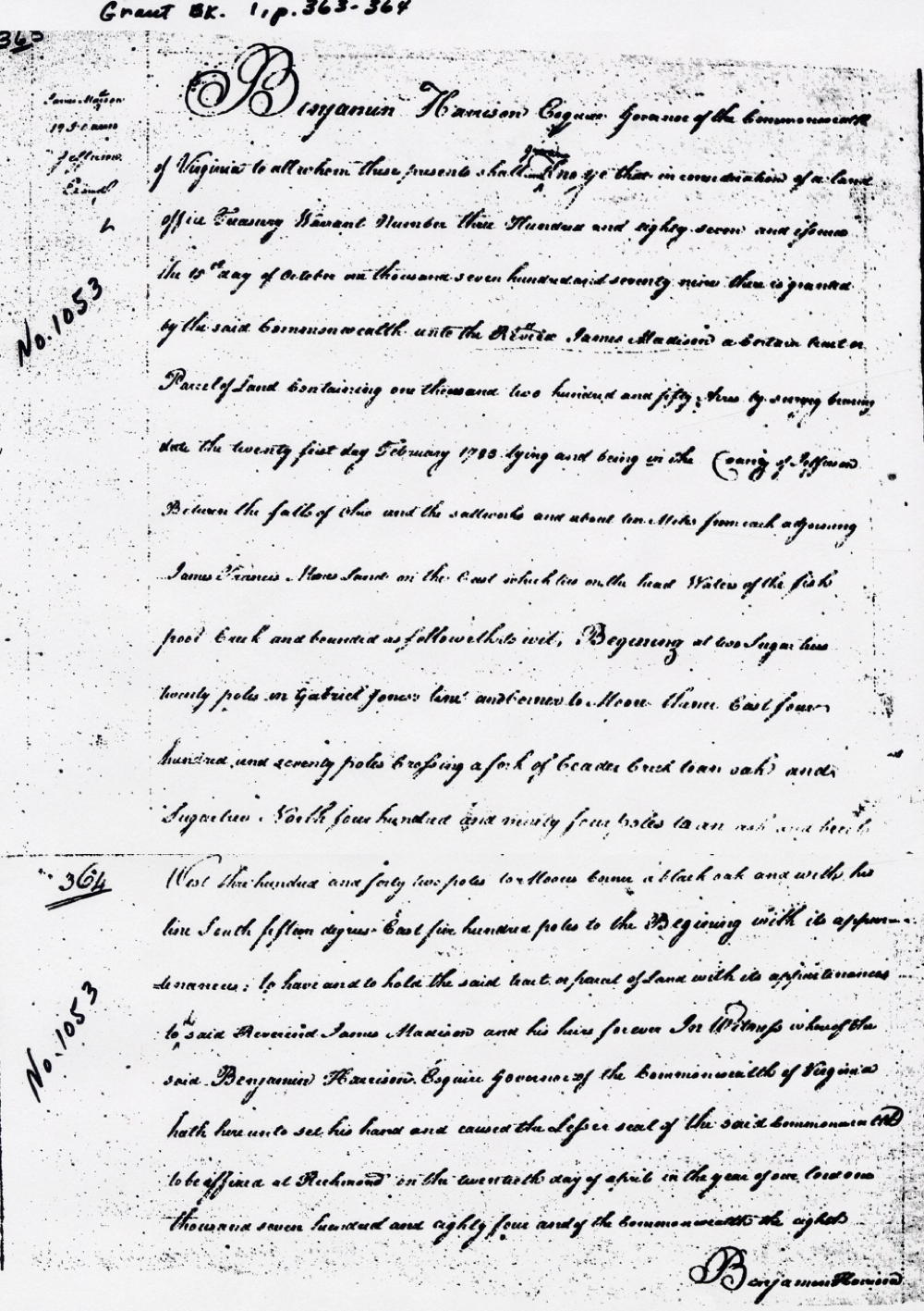
Benjamin Harrison Esquire, Governor of the Commonwealth of Virginia, to all to whom these presents shall come, greeting. Know ye that by virtue and in consideration of a land office treasury warrant number 387 and issued the 15th day of October 1779, there is granted by the said Commonwealth unto Reverend James Madison a certain tract or parcel of land containing 1250 acres by survey bearing date the 21st day of February 1783 lying and being in the county of Jefferson between the Falls of Ohio and the salt works and about 10 miles from each adjoining James Francis Moore’s land on the east which lies on the headwaters of the Fish Pool Creek and bounded as followeth. Beginning at two sugars trees 20 poles in Gabrial Jones’ line and corner to Moore, thence East 470 poles crossing a fork of Cedar Creek to an oak and sugar tree, North 494 poles to an ash and beech, West 342 poles to Moore’s corner, a black oak, and with his line South 15° East 500 poles to the beginning with its appurtenances to the said David Mitchell and George Wilson, and their heirs forever. In witness whereof the said Benjamin Harrison Esquire, Governor of the Commonwealth of Virginia, hath hereunto set his hand and caused the lesser seal of the said Commonwealth to be affixed at Richmond on the 20th day of April in the year of our Lord 1784, and of the Commonwealth the 8th. (signed) Benjamin Harrison
If you, the reader, have an interest in any particular part of our county history, and wish to contribute to this effort, use the form on our Contact Us page to send us your comments about this, or any Bullitt County History page. We welcome your comments and suggestions. If you feel that we have misspoken at any point, please feel free to point this out to us.
The Bullitt County History Museum, a service of the Bullitt County Genealogical Society, is located in the county courthouse at 300 South Buckman Street (Highway 61) in Shepherdsville, Kentucky. The museum, along with its research room, is open 10 a.m. to 4 p.m. Monday through Friday. Saturday appointments are available by calling 502-921-0161 during our regular weekday hours. Admission is free. The museum, as part of the Bullitt County Genealogical Society, is a 501(c)3 tax exempt organization and is classified as a 509(a)2 public charity. Contributions and bequests are deductible under section 2055, 2106, or 2522 of the Internal Revenue Code. Page last modified: 12 Apr 2026 . Page URL: bullittcountyhistory.org/bchistory/1053-madison.html