
From his research, Robert McDowell became an authority on the location of the Wilderness Road as it passed through Bullitt and Jefferson Counties on its way to the Falls of the Ohio River. He wrote about the road in 1962 for The Courier-Journal Magazine and again later in 1967 for The Louisville Magazine.
The following map is constructed by using Mr. McDowell's statements in those two writings, and what he had to say in his comments to the Filson Club about Bullitt's Lick and the other settlements of Bullitt County.
The map shows the approximate path of the Wilderness Road, and marks specific places along the trace with special significance. You may locate the places listed to the right of the map by hovering the cursor over the place name. Clicking on the place name will bring up a cloud window with additional information.
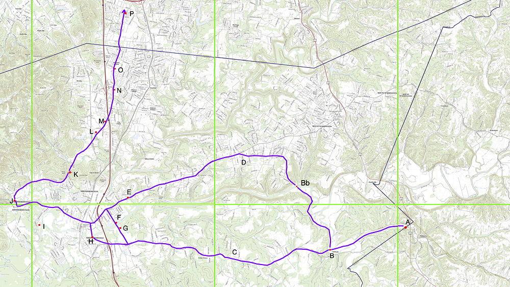
A. The Wilderness Road follows the East Fork of Cox's Creek into Bulllitt County near here.
B. East of Solitude the trace crosses the main branch of Cox's Creek. Near this point it separates into the two branches, north and south of Salt River.
Bb. The main crossing point on the Salt River was just downstream from McCullough Run near this point.
C. Southern Route. This route is uncertain, but uses modern roads and the terrain as guides.
D. Northern Route. This route is uncertain, but uses modern roads and the terrain as guides.
E. The northern route passed close by Brashear's Station, the first fort built in Bullitt County. It was just below the mouth of Floyd's Fork and less than a half mile from the river.
F. Dowdall's Station was built on the north side of Salt River about a mile below Brashear's Station, at a deep pool in Salt River. Soon a ferry was constructed to carry travelers.
G. Ben Pope built a cabin on the south side of Salt River, opposite Dowdall's Station. It served as a tavern for travelers who planned to take the ferry across the river.
H. The trace crossed Salt River near the future site of Shepherdsville, in the shallow water located there.
I. Mud Garrison was situated on the north bank of Salt River about a half mile above the mouth of Bullitt's Lick Run which put it very close to the Saltworks and at least a mile down river from the future site of Shepherdsville.
J. This is the general location of the Bullitt's Lick area.
K. Here the trace passed through Blue Lick Gap between Phelps Knob on the west, and Coleman Knob to the east, on its way north from Bullitt's Lick.
L. Clears Station, on the east bank of Clear Run, was located near here. The old trace ran fairly straight past this point.
M. About a mile south of Brooks Spring, where both the old trail and the new road cross a small branch of Brooks Run, John Floyd, who was an experienced Indian fighter, was fatally wounded by Indians.
N. Brooks Spring was another popular camping spot for travelers between the Falls of the Ohio and Harrodsburg.
O. Where the trail along the Blue Lick Road crosses a small branch of Brooks Run is where, in 1784,Walker Daniel, Kentucky's first attorney general, and George Keightly, a merchant from Ireland, were ambushed by Indians.
P. Leaving Bullitt County, the Fishpools, one of the most famous camping places along the Wilderness Road, were springs clustered along the creek within the space of an acre. Several rose and ran a few yards, only to sink again.
The trace passes up the Fishpool Creek Valley up to just before Southern High School where it merges with modern Preston Highway. Next it crosses a small branch of Fishpool Creek near the intersection of the Blue Lick Road with the highway, where a historical marker commemorating the Wilderness Road has been erected. Next we come to the Flat Lick area, where a log tavern was built at an early date, and was the site known as a hangout for robbers and cutthroats who infested the road through the Wetwoods. The trail descended gradually into the Wetwoods, a great dark swamp which was bound on the north about where Gilmore Lane runs today. It passed next past a Poplar level, flat rich tracts timbered with giant tulip poplar trees, was near the trace on Preston Street near what is now Audubon Park. Continuing it passed near Mulberry Hill tract, where the parents of George Rogers Clark settled after the Revolution in 1785. It ended in Kentucky at Fort Nelson, built by Richard Chenoweth in 1781, which stood on the bank of the river not far from the trace.
If you, the reader, have an interest in any particular part of our county history, and wish to contribute to this effort, use the form on our Contact Us page to send us your comments about this, or any Bullitt County History page. We welcome your comments and suggestions. If you feel that we have misspoken at any point, please feel free to point this out to us.
The Bullitt County History Museum, a service of the Bullitt County Genealogical Society, is located in the county courthouse at 300 South Buckman Street (Highway 61) in Shepherdsville, Kentucky. The museum, along with its research room, is open 10 a.m. to 4 p.m. Monday through Friday. Saturday appointments are available by calling 502-921-0161 during our regular weekday hours. Admission is free. The museum, as part of the Bullitt County Genealogical Society, is a 501(c)3 tax exempt organization and is classified as a 509(a)2 public charity. Contributions and bequests are deductible under section 2055, 2106, or 2522 of the Internal Revenue Code. Page last modified: 07 May 2026 . Page URL: bullittcountyhistory.org/bchistory/wr/wrmap.html