
William Christian was the first English owner of the tract of land that contained Bullitt's Lick. Thomas Bullitt had originally surveyed it for Christian in 1773, but it was re-surveyed in 1774 by James Douglas and this is the survey on which Christian's patent was granted.
Below is a digital image of the original plat drawn by Douglas and first recorded in Plat Book A, page 220 of Fincastle County, Virginia of which Kentucky was then a part.
Surveyed for William Christian by virtue of the governor's warrant to him as a captain in the Virginia regiment 1000 acres of land in Fincastle County on Salt River, a branch of the Ohio, about 20 miles from the Great Falls, which tract includes a salt spring & buffalo lick. Beginning at four maple trees on the river bank at letter A, the mouth of a small gut running up the meanders of the said river 442 poles to a white oak & sugar tree at B, thence N 39° W 380 poles to two walnuts and an honey locust near a small creek at C, thence S 55° W 380 poles to a white oak at the foot of a hill at D, thence S 39° E 488 poles to A the beginning. June 12th 1774. James Douglas, assistant surveyor. Wm. Preston, surveyor of Fincastle County.
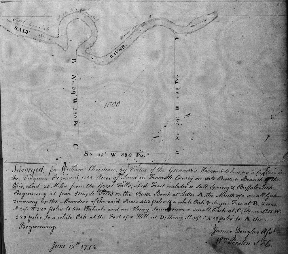
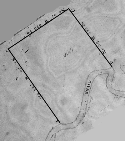
Note that this plat was drawn facing the south instead of the north, so Christian's land was on the north side of Salt River. We have rotated the plat below to better orient it.
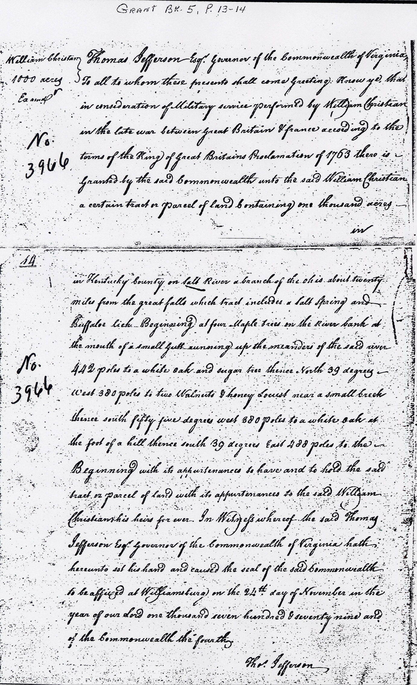
Although Douglas completed the survey in 1774, it was not until 1779 that Christian's patent was granted. A digital image of that patent, as written in Grant Book 5, pages 13-14, is shown below.
Virginia Grant Book 5, Pages 13-14
William Christian 1000 acres
Thomas Jefferson, Esq. governor of the Commonwealth of Virginia, To all to whom these presents shall come greeting. Knew ye that in consideration of Military service performed by William Christian in the late war between great Britain & france according to the terms of the King of great Britains Proclamation of 1763 there is granted by the said Commonwealth unto the said William Christian a certain tract or parcel of land containing one thousand acres in Kentucky County on Salt River a branch of the Ohio about twenty miles from the great falls which tract includes a Salt Spring and Buffaloe lick. Beginning at four Maple trees on the river bank at the mouth of a small gutt running up the meanders of the said river 442 poles to a white oak and sugar tree thence North 39 degrees West 380 poles to two Walnuts & honey Locust near a small break thence south fifty five degrees west 380 poles to a white oak at the foot of a hill thence south 39 degrees East 488 poles to the Beginning with its appurtenances to have and to hold the said tract or parcel of land with its appurtenances to the said William Christian, his heirs forever. In Witness whereof the said Thomas Jefferson Esq. governor of the Commonwealth of Virginia hath hereunto set his hand and caused the seal of the said Commonwealth to be affixed at Williamsburg on the 24th day of November in the year of our Lord one thousand seven hundred & seventy-nine and of the Commonwealth the fourth.
Thos Jefferson
Below is an image insert from Google showing the approximate location of this tract Click on the symbol in the lower right corner to find arrows that move the image, or use the plus and minus signs to zoom in or out. You may also put the cursor on the map and drag the image to where you want it.
If you, the reader, have an interest in any particular part of our county history, and wish to contribute to this effort, use the form on our Contact Us page to send us your comments about this, or any Bullitt County History page. We welcome your comments and suggestions. If you feel that we have misspoken at any point, please feel free to point this out to us.
The Bullitt County History Museum, a service of the Bullitt County Genealogical Society, is located in the county courthouse at 300 South Buckman Street (Highway 61) in Shepherdsville, Kentucky. The museum, along with its research room, is open 10 a.m. to 4 p.m. Monday through Friday. Saturday appointments are available by calling 502-921-0161 during our regular weekday hours. Admission is free. The museum, as part of the Bullitt County Genealogical Society, is a 501(c)3 tax exempt organization and is classified as a 509(a)2 public charity. Contributions and bequests are deductible under section 2055, 2106, or 2522 of the Internal Revenue Code. Page last modified: 09 May 2026 . Page URL: bullittcountyhistory.org/bchistory/wmchristianpatent.html