
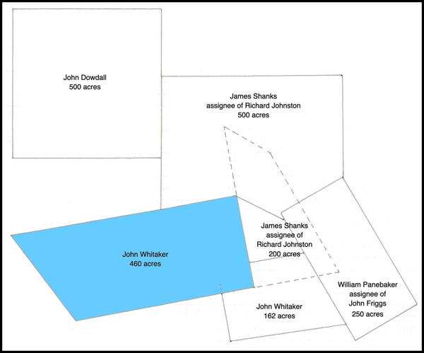
Isaac Cox surveyed this 460 acre tract on Cedar Creek for John Whitaker on 2 Jan 1783. He received the deed for it on 2 Dec 1785. This drawing shows the tract in relation to nearby tracts.
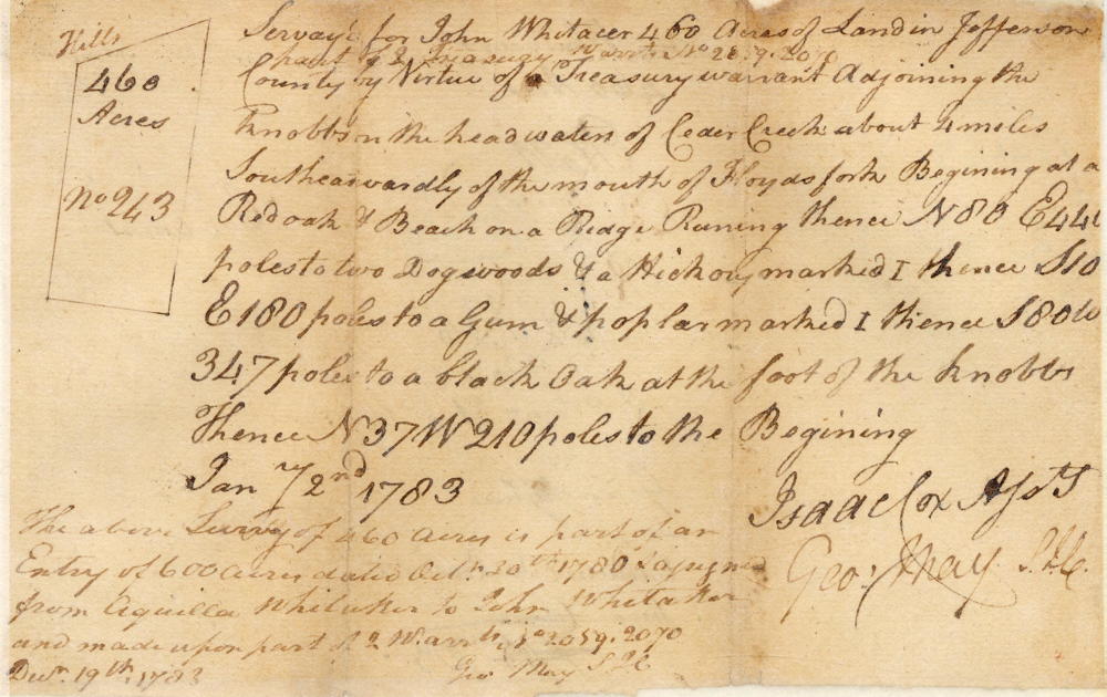
Survey
Surveyed for John Whitaker 460 acres of land in Jefferson County by virtue of part of 2 treasury warrants No. 2059, 2070 adjoining the knobs on the head waters of Cedar Creek about 4 miles southeastwardly of the mouth of Floyds fork, beginning at a red oak & beech on a ridge, running thence N 80 E 440 poles to two dogwoods & a hickory marked I, thence S10 E 180 poles to a gum & poplar marked I, thence S 80 W 347 poles to a black oak at the foot of the knobs, thence N 37 W 210 poles to the beginning. January 2nd 1783. Isaac Cox, surveyor.
The above survey of 460 acres is part of an entry of 600 acres dated October 30th 1780 & assigned from Aquilla Whitaker to John Whitaker and made upon part of 2 warrants No. 2059, 2070. December 19th 1783. (signed) George May, Surveyor for Jefferson County.
Deed
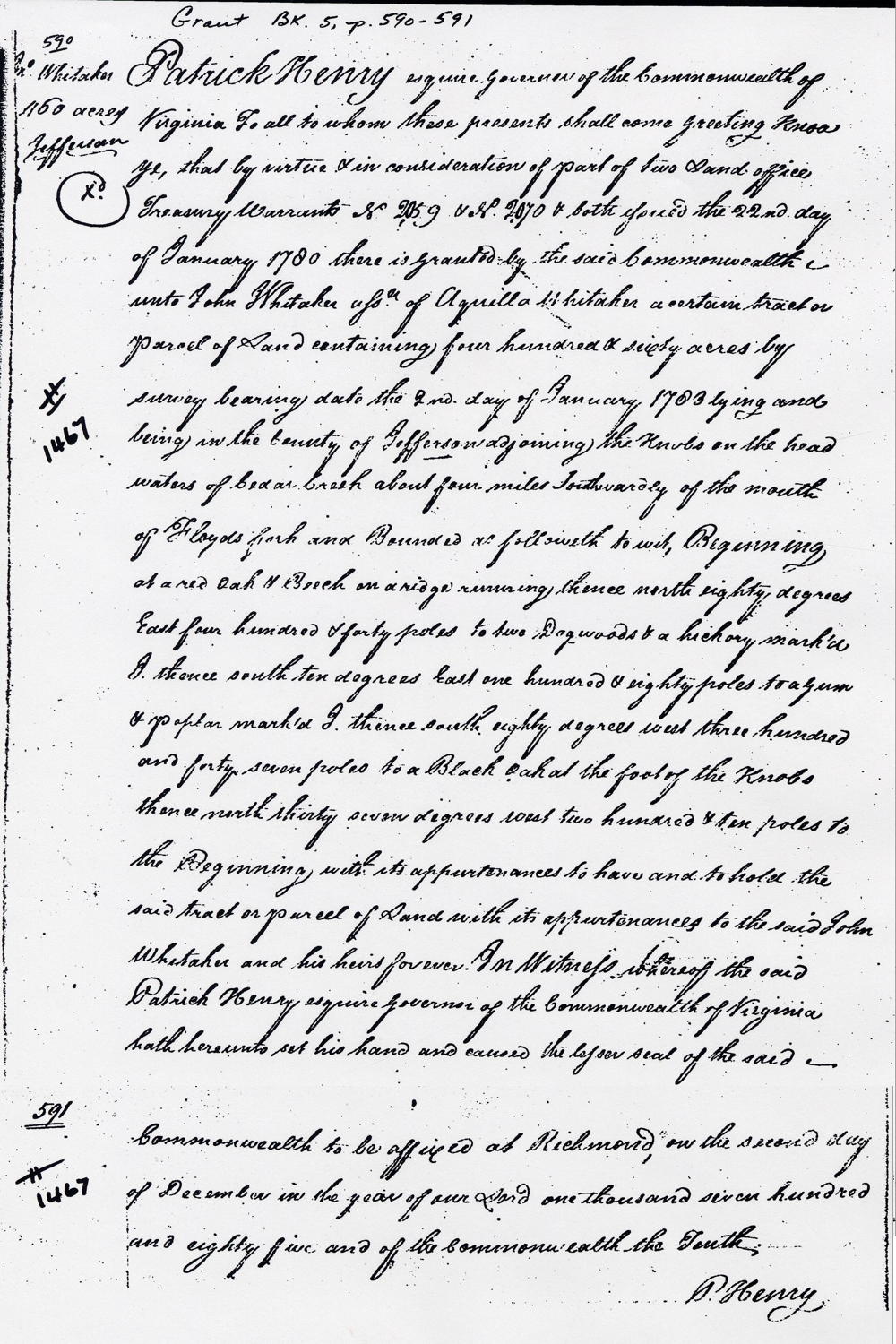
Virginia Grant Book 5, pages 590-1
Patrick Henry Esquire, Governor of the Commonwealth of Virginia, to all to whom these presents shall come, greeting. Know ye that by virtue and in consideration of part of two land office treasury warrants No. 2059 & No. 2070 & both issued the 22nd day of January 1780, there is granted by the said Commonwealth unto John Whitaker, assignee of Aquilla Whitaker, a certain tract or parcel of land containing 460 acres by survey bearing date the 2nd day of January 1783, lying and being in the county of Jefferson adjoining the knobs on the head waters of Cedar Creek about four miles southwardly of the mouth of Floyd's Fork and bounded as followeth to wit. Beginning at a red oak & beech on a ridge, running thence North 80° East 440 poles to two dogwoods & a hickory marked I, thence South 10° East 180 poles to a gum & poplar marked I, thence South 80° West 347 poles to a black oak at the foot of the knobs, thence North 37° West 210 poles to the beginning with its appurtenances to the said John Whitaker and his heirs forever. In witness whereof the said Patrick Henry Esquire, Governor of the Commonwealth of Virginia, hath hereunto set his hand and caused the lesser seal of the said Commonwealth to be affixed at Richmond on the 2nd day of December in the year of our Lord 1785 and of the Commonwealth the 10th. (signed) P. Henry
If you, the reader, have an interest in any particular part of our county history, and wish to contribute to this effort, use the form on our Contact Us page to send us your comments about this, or any Bullitt County History page. We welcome your comments and suggestions. If you feel that we have misspoken at any point, please feel free to point this out to us.
The Bullitt County History Museum, a service of the Bullitt County Genealogical Society, is located in the county courthouse at 300 South Buckman Street (Highway 61) in Shepherdsville, Kentucky. The museum, along with its research room, is open 10 a.m. to 4 p.m. Monday through Friday. Saturday appointments are available by calling 502-921-0161 during our regular weekday hours. Admission is free. The museum, as part of the Bullitt County Genealogical Society, is a 501(c)3 tax exempt organization and is classified as a 509(a)2 public charity. Contributions and bequests are deductible under section 2055, 2106, or 2522 of the Internal Revenue Code. Page last modified: 12 Sep 2024 . Page URL: bullittcountyhistory.org/bchistory/whitaker1467.html