
Hugh Caldwell of Bullitt County and John Hunter of Wheeling, Virginia sold "two eighths" of their joint Bullitt County holdings to John C. Tarr of Brook County, Virginia. Individually they would later sell the lands to William Patterson. The deed below describes Tarr's sale to Patterson.
Bullitt County Deed Book N, Pages 392-395
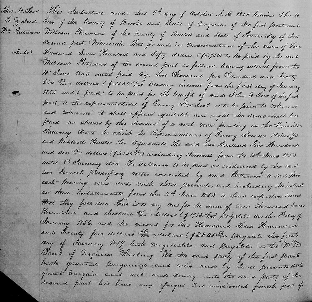
This indenture made this 6th day of October A.D. 1855 between John C. Tarr of the County of Brooke and State of Virginia of the first part and William Patterson of the County of Bullitt and State of Kentucky of the second part. Witnesseth that for and in consideration of the sum of $5,750 to be paid by the said William Patterson of the second part as follows, bearing interest from the 10th June 1853 until paid viz. $2,566.88 bearing interest from the first day of January 1855 to the representatives of Emory Low dec'd or to be paid to whoever and wherever it shall appear equitable and right the same shall be paid as shown by the decision of a suit now pending in the Louisville Chancery Court in which the representatives of Emory Low are plaintiffs and Caldwell, Hunter & Co. defendants. The said $2566.88 including interest from the 10th June 1853 until 1st January 1855. The balance to be paid as evidenced by the said two several promissory notes executed by said Patterson to said Tarr, each bearing even date with these presents and including the interest on these installments from the 10th June 1953 to their respective times that they fall due. that is to say one for the sum of $1713.25 payable on the 1st day of January 1856 and the second for $2325.56 payable the first day of January 1857, both negotiable and payable in the N. M. Bank of Virginia, Wheeling.
He the said party of the first part hath granted, bargained and sold and by these presents doth grant, bargain and sell and convey unto the said party of the second part, his heirs and assigns, one undivided fourth part of the following described tracts of land situate in the County of Bullitt and State of Kentucky, namely one tract of land about 200 acres, more or less on the waters of Crooked Creek (with the machinery and furnace) bounded thus.
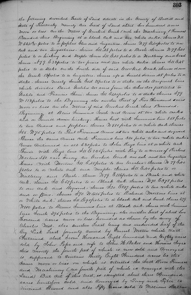
Beginning at a black oak & two white oaks, thence N 11° W 324.6 poles to a poplar, elm and sugar tree, thence N 79° E 40 poles to an oak and two sugar trees, thence S 11° E 48 poles to a beech, thence N 79° E 40 poles to a hickory and maple, thence S 11° E 40 poles to a mulberry and beech, thence N 79° E 33 poles to two pines and two white oaks, thence S 11° E 48 poles to a stake on the south side of Crooked Creek, thence down the creek 13 poles to a sugar tree, thence up a small drain 48 poles to a stake, thence nearly southeast 18 poles to a stake on the original line which divides David Grable's 200 acres from the other 300 patented to Grable and Francis Shain, thence S 11° E 140 poles to a stake, thence S 79° W 113 poles to the beginning.
Also another tract of 5000 acres more or less on the waters of said Crooked Creek, thus bounded. Beginning at Denis Simmons' southwest corner at two white oaks and small hickory, thence East with Simmons' line 850 poles to two cedars and poplar, thence North 980 poles to a white oak, thence S 85° W 75 poles to Paul Froman's corner at two white oaks and dogwood, thence the same course with Froman's line 320 poles to two white oaks course continued in all 630 poles to John Ray's line at a white oak, thence with Ray's line S 11° E 125 poles with Ray to a corner of Richard Morton's 500 acre survey on Crooked Creek, an ash and two sugar trees, thence with Morton S 11° E 48 poles to two beeches, thence N 79° E 40 poles to a white oak and maple, thence S 11° E 40 poles to a mulberry and beech, thence N 79° E 116 poles to a beech and white oak, thence S 11° E 50 poles to a black oak, thence N 70° E 378 poles to an oak and dogwood, thence S 20° E 127 poles to two white oaks and a pine, thence S 70° W 215 poles to Richard Morton's line at a white oak, thence S 11° E 90 poles to a black oak and beech, thence S 79° W 100 poles to Dennis Simmons' line at black oak, thence with said Simmons' line South 395 poles to the beginning.
Also another tract of about 2000 acres more or less bounded as shown by the survey of Charles West.
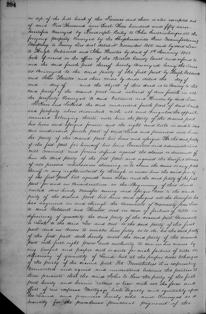
Also another tract being one undivided half of the Dry Lick tract, formerly owned by General Walton, which tract contained about 7880 acres sold by John Pope and wife to John H. Baker and Thomas Joyce, this moiety the fourth part of which is now sold and conveyed, is supposed to contain 3800 acres, be the same more or less, and on which is situated the Salt River Furnace and machinery one fourth part of which is conveyed with the land. But out of this tract is excepted about 300 acres heretofore sold and conveyed by Quirey and Tyler to Vincent Steward, and also fifty acres sold to William Dalton on top of the hill back of the furnace, and there is also excepted out of said 5000 acre tract 350 acres heretofore conveyed by Randolph Railey to John Snellenbarger.
All the foregoing property conveyed by the Shepherdsville Iron Manufacturing Company to Emory Low dec'd dated 4th of November 1850, and by the said Low to Hugh Caldwell and John Hunter by deed of the 1st of January 1851, both of record in the office of the Bullitt County Court and referred to and the said fourth part thereof hereby cnoveyed being the same as conveyed to the said party of the first part by Hugh Caldwell and John Hunter and their wives by deeds dated the __ day of __ and __ day of __ and the object of this deed is to convey to the said party of the second part and interest of one fourth in all the property conveyed to said Caldwell and Hunter by said Low.
To have and to hold the said undivided fourth part of said land and property above described with all and singular the appurtenances belonging thereto unto him the party of the second part, his heirs and assigns forever, and the right and title in and to said one undivided fourth part of said land and premises unto him the party of the second part, his heirs and assigns. He the said party of the first part for himself, his heirs, executors and administrators will warrant and forever defend against the claims or demands of him the said party of the first part and against the lawful claims of all persons whatsoever claiming or to claim the same or any part thereof, or any right or interest by, through or under him the said party of the first part, but against none other. And the said party of the first part for and in consideration in the beginning of this deed recited does hereby transfer, convey and assign over to the said party of the second part, his heirs and assigns, all the benefits he has acquired in and through the covenants of warranty from Low to said Caldwell and Hunter, and in case of failure of title or deficiency of quantity the said party of the second part covenants to look to the said Low and not the said party of the first part, and in order to enable him fully so to do, he the said party of the first part doth hereby invest the said party of the second part with full right, power and authority to sue in his name by any lawful and proper suit or suits for such failure of title or deficiency of quantity of land, but at the proper costs and charges of the party of the second part.
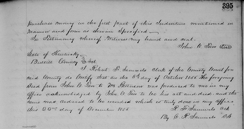
Yet, nevertheless it is expressly covenanted and agreed and understodd between the parties to these presents that the said John C. Tarr, the party of the first part hereby and herein retains a lien with all the force and effect of an express mortgage both legally and equitably upon the land and premises hereby sold and conveyed as a security for the punctual payment of the purchase money in the first part of this indenture mentioned in manner and form as therein specified.
In testimony whereof witness my hand and seal. (signed) John C. Tarr
The Bullitt County History Museum, a service of the Bullitt County Genealogical Society, is located in the county courthouse at 300 South Buckman Street (Highway 61) in Shepherdsville, Kentucky. The museum, along with its research room, is open 10 a.m. to 4 p.m. Monday through Friday. Saturday appointments are available by calling 502-921-0161 during our regular weekday hours. Admission is free. The museum, as part of the Bullitt County Genealogical Society, is a 501(c)3 tax exempt organization and is classified as a 509(a)2 public charity. Contributions and bequests are deductible under section 2055, 2106, or 2522 of the Internal Revenue Code. Page last modified: 04 Sep 2025 . Page URL: bullittcountyhistory.org/bchistory/tarr-patterson.html