
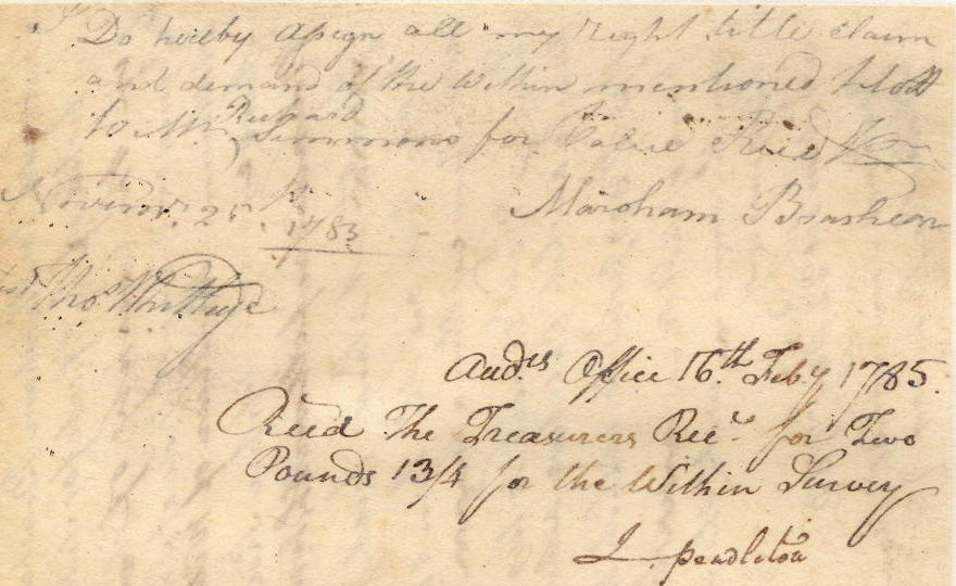
Marsham Brashear obtained a 400 acre settlement and 1000 acre preemption based on his making a settlement and raising a crop in 1776 in this area. He then signed over the 400 settlement acres and 600 or the 1000 preemption acres to Richard Simmons, as shown below.
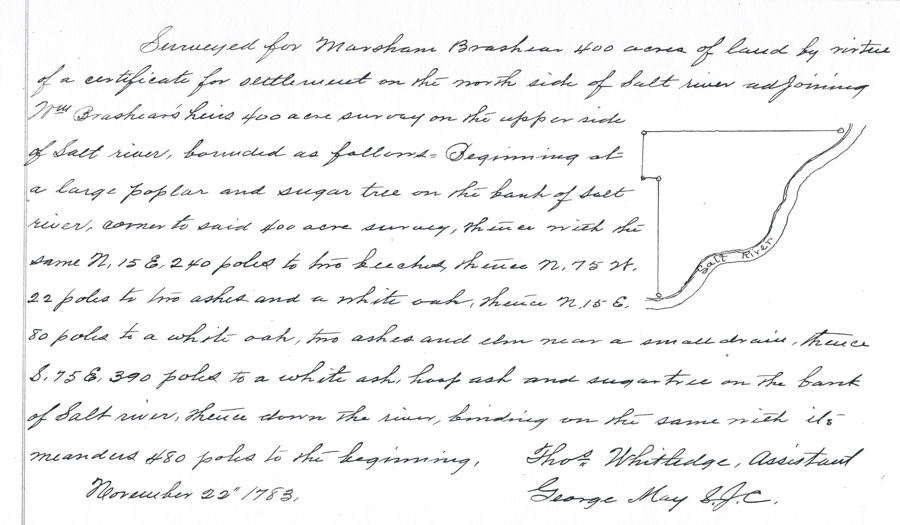
This next image is taking from the Bullitt County Plat Book I, and shows that he had his 400 acres settlement tract surveyed on the Salt River on 22 Nov 1783.
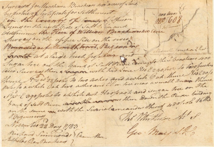
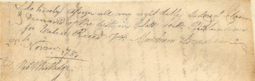
Next is a transcription of the original survey document, followed by the front and back of that document. You will note that the backside indicates that he sold this 400 acres to Richard Simmons.
Survey
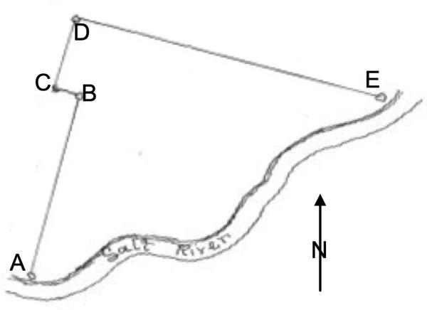
Surveyed for Marsham Brashears 400 acres of land by virtue of certificate for settlement in the county of Jefferson lying on the north side of Salt River and adjoining the heir of William Brashears 400 acre survey on the upper side on the river bounded as followeth to wit. Beginning at [A] a large beech, poplar and sugar tree on the bank of Salt River corner to the said Brashear's 400 acre survey, then with his line N 15 E 240 poles to [B] two beeches, thence N 75 W 22 poles to [C] two ashes and a white oak, thence N 15 E 80 poles to [D] a white oak, two ashes and elm trees near a small drain, thence S 75 E 390 poles to [E] a white ash, hoop ash and sugar tree on the bank of Salt River, then down the river binding on the same with the several meanders thereof 480 poles to the beginning. November 22 day 1783. Chain carriers: Richard Simmons, Nicholas Ray Brashear. Thomas Whitledge, Assistant Surveyor
Deed
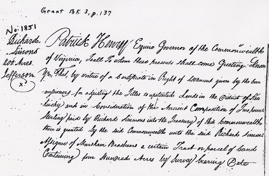
Virginia Grant Book 3, p. 137
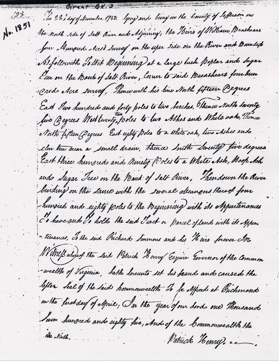
Patrick Henry Esquire, Governor of the Commonwealth of Virginia, to all to whom these presents shall come, greeting. Know ye that by virtue of a certificate in right of settlement given by the commissioners for adjusting the titles to unpatented lands in the district of Kentucky, and in consideration of two pounds sterling paid by Richard Simmons into the treasury of this Commonwealth there is granted by the said Commonwealth unto the said Richard Simmons assignee of Marsham Brashears a certain tract or parcel of land containing four hundred acres by survey bearing date the 22nd day of November 1783, lying and being in the county of Jefferson on the north side of Salt River and adjoining the heirs of William Brashear's four hundred acre survey on the upper side on the river and bounded as followeth, to wit. Beginning at a large beech, poplar and sugar tree on the bank of Salt River, corner to said Brashear's four hundred acre survey, thence with his line North fifteen degrees East two hundred and forty poles to two beeches, thence North seventy five degrees West twenty two poles to two ashes and white oaks, thence North fifteen degrees EAst eighty poles to a white oak, two ashes and elm tred near a small drain, thence South seventy five degrees East three hundred and ninety poles to a white ash, hoop ash and sugar tree on the bank of Salt River, then down the river binding on the same with the several meanders thereof four hundred and eighty poles to the beginning with its appurtenances to have and to hold the said tract or parcel of land with its appurtenances to the said Richard Simmons and his heirs forever. In witness whereof the said Patrick Henry Esquire, Governor of the Commonwealth of Virginia, hath hereunto set his hand and caused the lesser seal of the said Commonwealth to be affixed at Richmond on the first day of April, in the year of our Lord one thousand seven hundred and eighty five, and of the Commonwealth the ninth. (signed) Patrick Henry
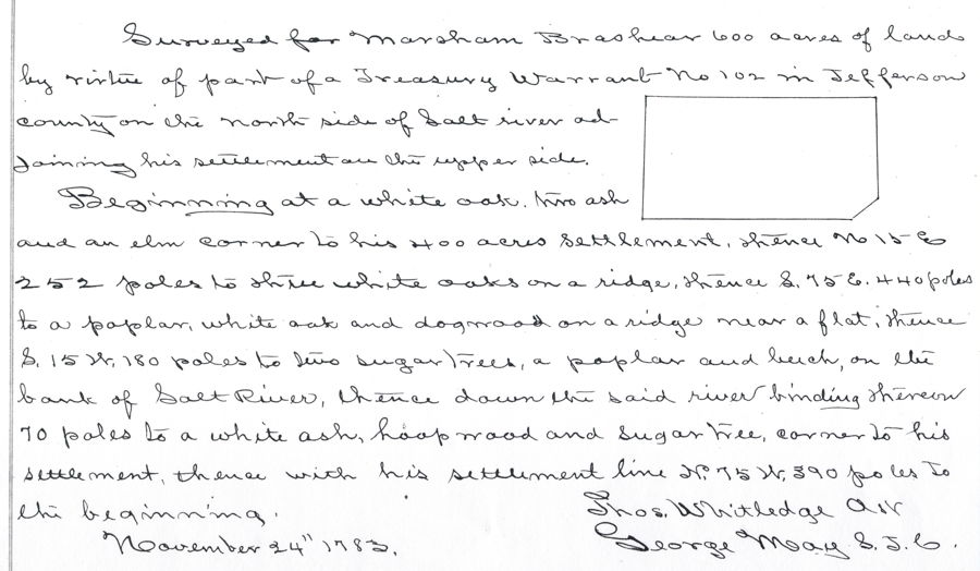
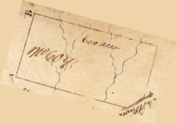
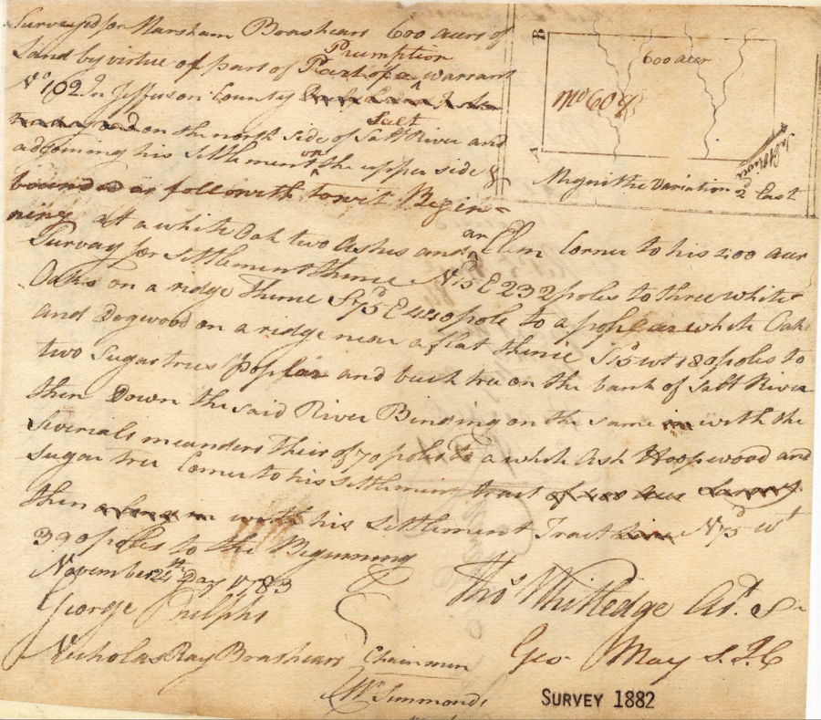
This next image is taking from the Bullitt County Plat Book I, and shows that Marsham Brashear had the other 600 acres of his preemption surveyed on 24 Nov 1783.
Survey
Surveyed for a Marsham Brashear 600 acres of land by virtue of part of a preemption warrant number 102 in Jefferson County on the north side of Salt River adjoining his settlement on the upper side. Beginning at a white oak, two ash and an elm corner to his 400 acres settlement, thence North 15° East 252 poles to 3 white oaks on a ridge, thence South 75° East 440 poles to a poplar, white oak and dogwood on a ridge near a flat, thence South 15° West 180 poles to two sugar trees, a poplar and beech on the bank of salt River, thence down the said river binding thereon 70 poles to a white ash, hoop wood and sugar tree corner to his settlement, thence with his settlement line North 75° West 390 poles to the beginning. November 24th 1783. Thomas Whitledge, surveyor.
Here is the original survey, front and back. Note that the back indicates that Brashear also sold this tract to Richard Simmons.
Deed
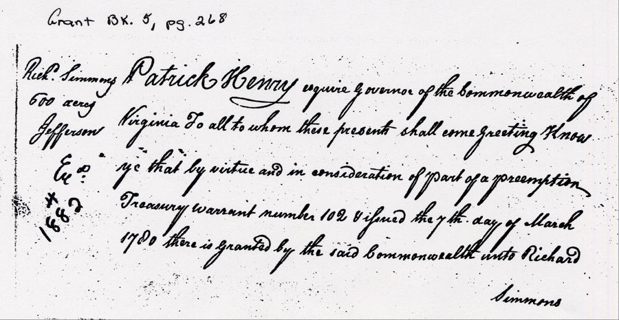
Virginia Grant Book 5, page 268-9
Patrick Henry Esquire, Governor of the Commonwealth of Virginia, to all to whom these presents shall come, greeting. Know ye that by virtue and in consideration of part of a land office preemption treasury warrant No. 102 and issued the 7th day of March 1780, there is granted by the said Commonwealth unto Richard Simmons assignee of Marsham Brashears a certain tract or parcel of land containing six hundred acres by survey bearing date the 24th day of November 1783, lying and being in the county of Jefferson on the north side of Salt River & adjoining his settlement on the upper side and bounded as followeth, to wit. Beginning at a white oak, two ash and an elm corner to his 400 acres settlement, thence North 15° East 252 poles to 3 white oaks on a ridge, thence South 75° East 440 poles to a poplar, white oak and dogwood on a ridge near a flat, thence South 15° West 180 poles to two sugar trees, a poplar and beech on the bank of salt River, thence down the said river binding thereon 70 poles to a white ash, hoop wood and sugar tree corner to his settlement, thence with his settlement line North 75° West 390 poles to the beginning with its appurtenances to have and to hold the said tract or parcel of land with its appurtenances to the said Richard Simmons and his heirs forever. In witness whereof the said Patrick Henry Esquire, Governor of the Commonwealth of Virginia, hath hereunto set his hand and caused the lesser seal of the said Commonwealth to be affixed at Richmond on the 19th day of April, in the year of our Lord one thousand seven hundred and eighty five, and of the Commonwealth the ninth. (signed) Patrick Henry

If you, the reader, have an interest in any particular part of our county history, and wish to contribute to this effort, use the form on our Contact Us page to send us your comments about this, or any Bullitt County History page. We welcome your comments and suggestions. If you feel that we have misspoken at any point, please feel free to point this out to us.
The Bullitt County History Museum, a service of the Bullitt County Genealogical Society, is located in the county courthouse at 300 South Buckman Street (Highway 61) in Shepherdsville, Kentucky. The museum, along with its research room, is open 10 a.m. to 4 p.m. Monday through Friday. Saturday appointments are available by calling 502-921-0161 during our regular weekday hours. Admission is free. The museum, as part of the Bullitt County Genealogical Society, is a 501(c)3 tax exempt organization and is classified as a 509(a)2 public charity. Contributions and bequests are deductible under section 2055, 2106, or 2522 of the Internal Revenue Code. Page last modified: 12 Sep 2024 . Page URL: bullittcountyhistory.org/bchistory/richard-simmons-400.html