
On 29 Aug 1798, Samuel Smyth surveyed 200 acres along Wilson's Creek for James Samuels, as shown below. Samuel received his deed to the land on 14 Jun 1800.
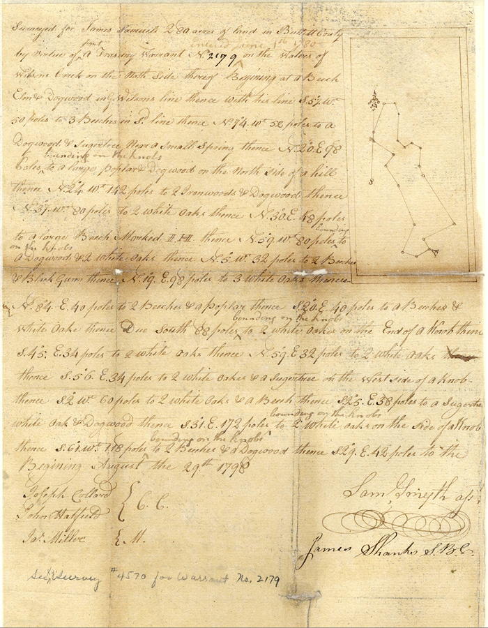
Survey
Surveyed for James Samuels 280 acres of land in Bullitt County by virtue of part of a treasury warrant No. 2199, entered June 1st, 1780, on the waters of Wilson's Creek on the north side thereof, Beginning at a beech, elm and dogwood in George Willson's line, thence with his line South 57° West 50 poles to three beeches in said line, thence North 74° West 52 poles to a dogwood and sugar tree near a small spring, thence North 20° East 98 poles bounding on the knobs to a large poplar and dogwood on the north side of a hill, thence North 24° West 142 poles to two ironwoods and dogwood, thence North 37° West 80 poles to two white oaks, thence North 30° East 48 poles to a large beech marked I H, thence North 59° West 80 poles bounding on the knobs to a dogwood and two white oaks, thence North 5° West 32 poles to two beeches and black gum, thence North 19° East 90 poles to three white oaks, thence North 84° East 40 poles to two beeches and a poplar, thence South 20° East 40 poles to a beech and white oak, thence due South 88 poles bounding on the knobs to two white oaks on the end of knob, thence South 45° East 34 poles to two white oaks, thence North 59°East 32 poles to two white oaks, thence South 56° East 34 poles to two white oaks and a sugar tree on the west side of a knob, thence South 2° West 60 poles to two white oaks and a beech, thence South 25° East 38 poles to a sugar tree, white oak and dogwood, thence South 31° East 172 poles bounding on the knobs to two white oaks on the side of a knob, thence South 61° West 118 poles bounding on the knobs to two beeches and a dogwood, thence South 29° East 42 poles to the beginning. August the 29th, 1798. Samuel Smyth, surveyor
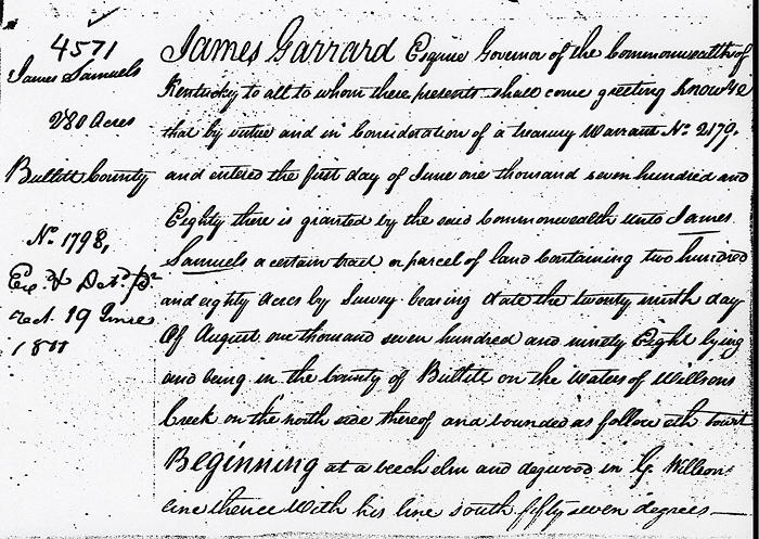
Deed
James Garrard Esquire, Governor of the Commonwealth of Kentucky, to all to whom these presents shall come, greeting. Know ye that by virtue and in consideration of part of a land office treasury warrant No. 2179, and entered the first day of June 1780, there is granted by the said Commonwealth unto James Samuels a certain tract or parcel of land contaiing 280 acres by survey bearing date the 29th day of August 1798, lying and being in the county of Bullitt on the waters of Wilson's Creek, on the north side thereof, and bounded as followeth, to wit.
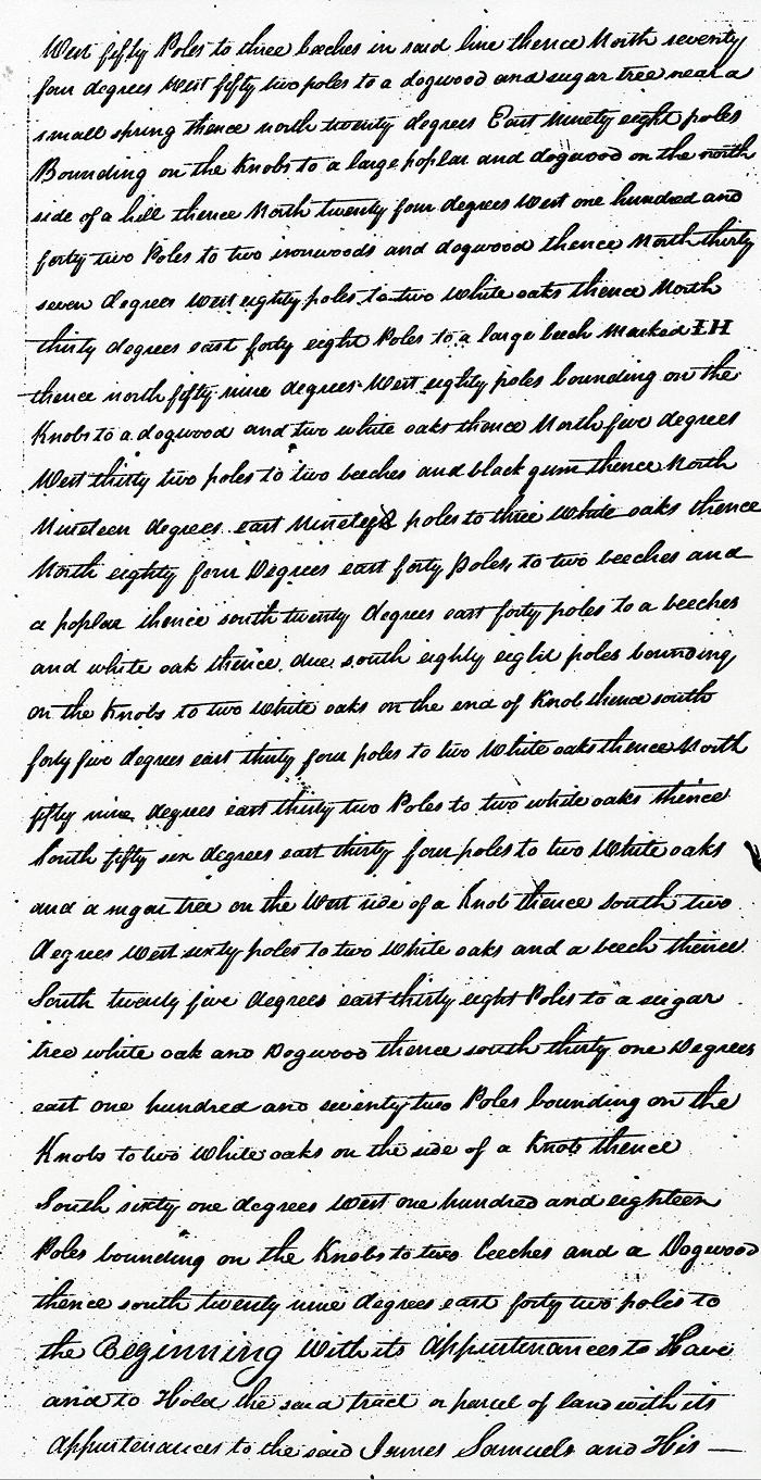
Beginning at a beech, elm and dogwood in George Willson's line, thence with his line South 57° West 50 poles to three beeches in said line, thence North 74° West 52 poles to a dogwood and sugar tree near a small spring, thence North 20° East 98 poles bounding on the knobs to a large poplar and dogwood on the north side of a hill, thence North 24° West 142 poles to two ironwoods and dogwood, thence North 37° West 80 poles to two white oaks, thence North 30° East 48 poles to a large beech marked I H, thence North 59° West 80 poles bounding on the knobs to a dogwood and two white oaks, thence North 5° West 32 poles to two beeches and black gum, thence North 19° East 90 poles to three white oaks, thence North 84° East 40 poles to two beeches and a poplar, thence South 20° East 40 poles to a beech and white oak, thence due South 88 poles bounding on the knobs to two white oaks on the end of knob, thence South 45° East 34 poles to two white oaks, thence North 59°East 32 poles to two white oaks, thence South 56° East 34 poles to two white oaks and a sugar tree on the west side of a knob, thence South 2° West 60 poles to two white oaks and a beech, thence South 25° East 38 poles to a sugar tree, white oak and dogwood, thence South 31° East 172 poles bounding on the knobs to two white oaks on the side of a knob, thence South 61° West 118 poles bounding on the knobs to two beeches and a dogwood, thence South 29° East 42 poles to the beginning with its appurtenances.
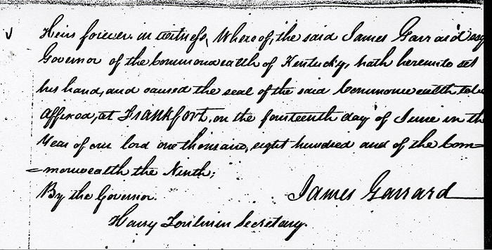
To have and to hold the said tract or parcel of land with its appurtenances to the said James Samuel and his heirs forever. In witness whereof the said Isaac Shelby Esquire, Governor of the Commonwealth of Kentucky, hath hereunto set his hand and caused the seal of the Commonwealth to be affixed at Frankfort on the 14th day of June in the year of our Lord 1800, and of the Commonwealth the ninth. (signed) James Garrard
If you, the reader, have an interest in any particular part of our county history, and wish to contribute to this effort, use the form on our Contact Us page to send us your comments about this, or any Bullitt County History page. We welcome your comments and suggestions. If you feel that we have misspoken at any point, please feel free to point this out to us.
The Bullitt County History Museum, a service of the Bullitt County Genealogical Society, is located in the county courthouse at 300 South Buckman Street (Highway 61) in Shepherdsville, Kentucky. The museum, along with its research room, is open 10 a.m. to 4 p.m. Monday through Friday. Saturday appointments are available by calling 502-921-0161 during our regular weekday hours. Admission is free. The museum, as part of the Bullitt County Genealogical Society, is a 501(c)3 tax exempt organization and is classified as a 509(a)2 public charity. Contributions and bequests are deductible under section 2055, 2106, or 2522 of the Internal Revenue Code. Page last modified: 23 Apr 2026 . Page URL: bullittcountyhistory.org/bchistory/ok4571-jamessamuels.html