
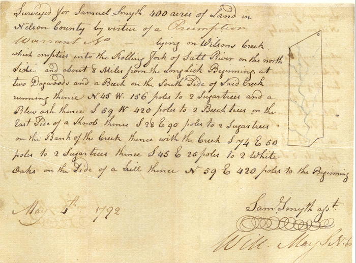
On 4 May 1792, Samuel Smyth surveyed 400 acres along Wilson's Creek for himself, as shown below. He received his deed to the land on 8 Mar 1796.
Survey
Surveyed for Samuel Smyth 400 acres of land in Nelson County by virtue of a preemption warrant No. __ lying on Wilson's Creek which empties into the Rolling Fork of Salt River on the north side, and about 8 miles from the Long Lick. Beginning at two dogwoods and a beech on the south side of said creek, running thence North 45° West 156 poles to two sugar trees and blue ash, thence South 59° West 420 poles to 2 beech trees on the east side of a knob, thence South 28° East 90 poles to two sugar trees on the bank of the creek, thence with the creek South 74° East 50 poles to two sugar trees, thence South 45° East 25 poles to two white oaks on the side of a hill, thence North 59° East 420 poles to the beginning. May 4th 1792. Sam Smyth, surveyor.
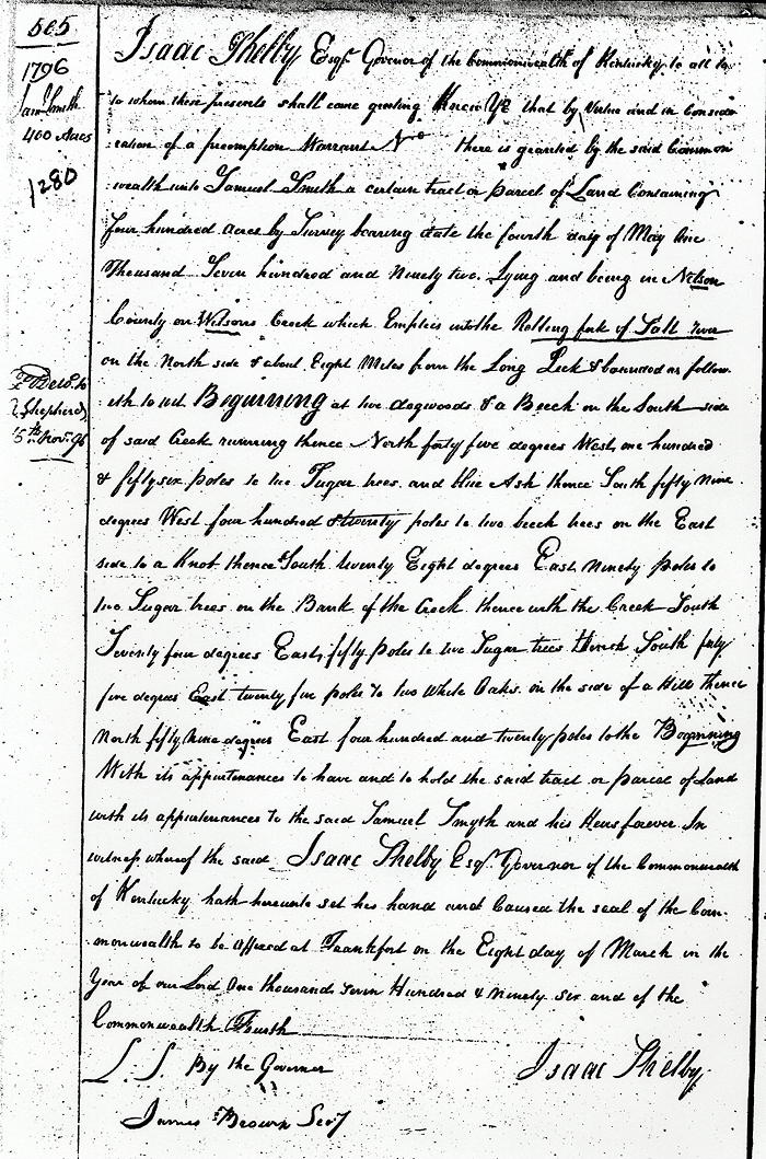
Deed
Isaac Shelby Esquire, Governor of the Commonwealth of Kentucky, to all to whom these presents shall come, greeting. Know ye that by virtue and in consideration of part of a preemption warrant No. __, there is granted by the said Commonwealth unto Samuel Smith a certain tract or parcel of land containing 400 acres by survey bearing date the 4th day of May 1792, lying and being in Nelson County on Wilson's Creek which empties into the Rolling Fork of Salt River on the north side and about eight miles from the Long Lick, and bounded as followeth, to wit.
Beginning at two dogwoods and a beech on the south side of said creek, running thence North 45° West 156 poles to two sugar trees and blue ash, thence South 59° West 420 poles to 2 beech trees on the east side of a knob, thence South 28° East 90 poles to two sugar trees on the bank of the creek, thence with the creek South 74° East 50 poles to two sugar trees, thence South 45° East 25 poles to two white oaks on the side of a hill, thence North 59° East 420 poles to the beginning with its appurtenance.
To have and to hold the said tract or parcel of land with its appurtenances to the said Samuel Smyth and his heirs forever. In witness whereof the said Isaac Shelby Esquire, Governor of the Commonwealth of Kentucky, hath hereunto set his hand and caused the seal of the Commonwealth to be affixed at Frankfort on the 8th day of March in the year of our Lord 1796, and of the Commonwealth the fourth. (signed) Isaac Shelby
If you, the reader, have an interest in any particular part of our county history, and wish to contribute to this effort, use the form on our Contact Us page to send us your comments about this, or any Bullitt County History page. We welcome your comments and suggestions. If you feel that we have misspoken at any point, please feel free to point this out to us.
The Bullitt County History Museum, a service of the Bullitt County Genealogical Society, is located in the county courthouse at 300 South Buckman Street (Highway 61) in Shepherdsville, Kentucky. The museum, along with its research room, is open 10 a.m. to 4 p.m. Monday through Friday. Saturday appointments are available by calling 502-921-0161 during our regular weekday hours. Admission is free. The museum, as part of the Bullitt County Genealogical Society, is a 501(c)3 tax exempt organization and is classified as a 509(a)2 public charity. Contributions and bequests are deductible under section 2055, 2106, or 2522 of the Internal Revenue Code. Page last modified: 23 Apr 2026 . Page URL: bullittcountyhistory.org/bchistory/ok1280-samuelsmyth.html