
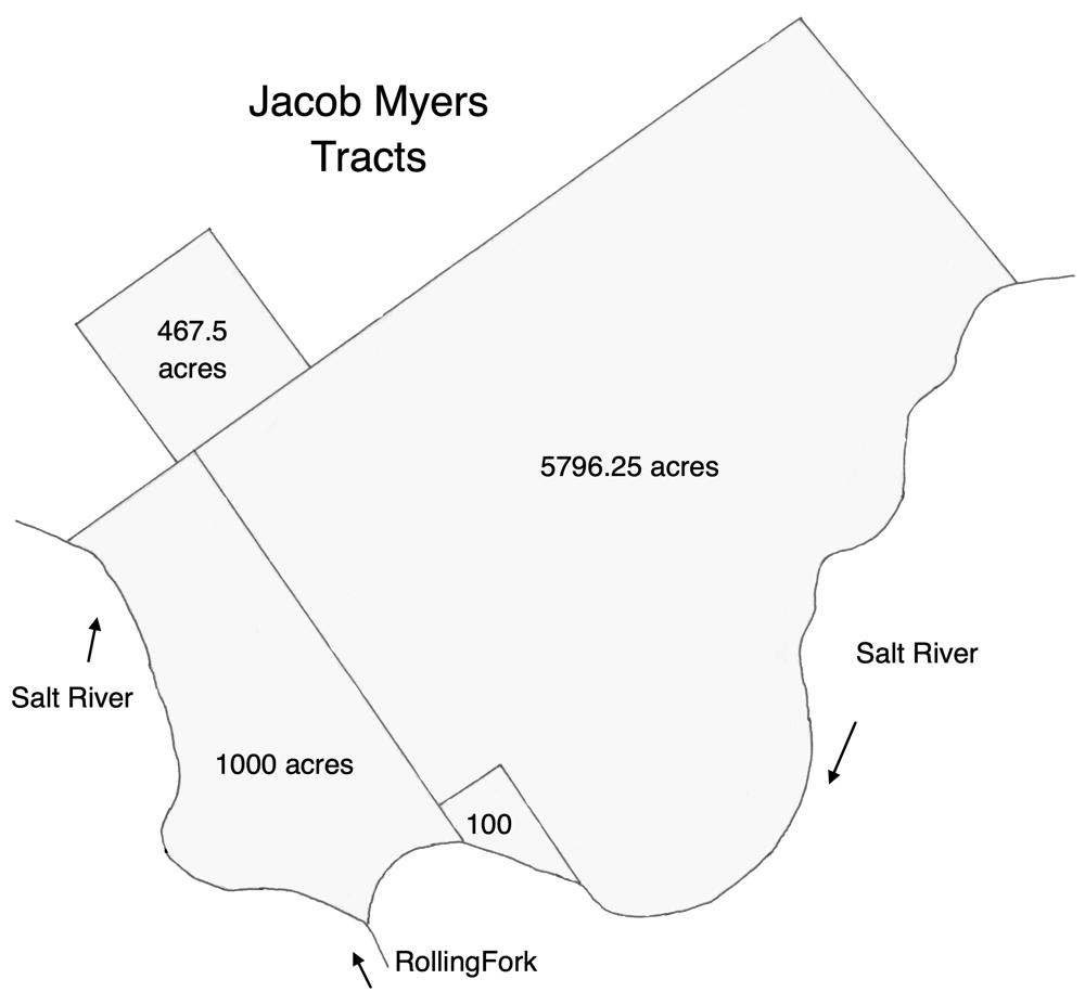
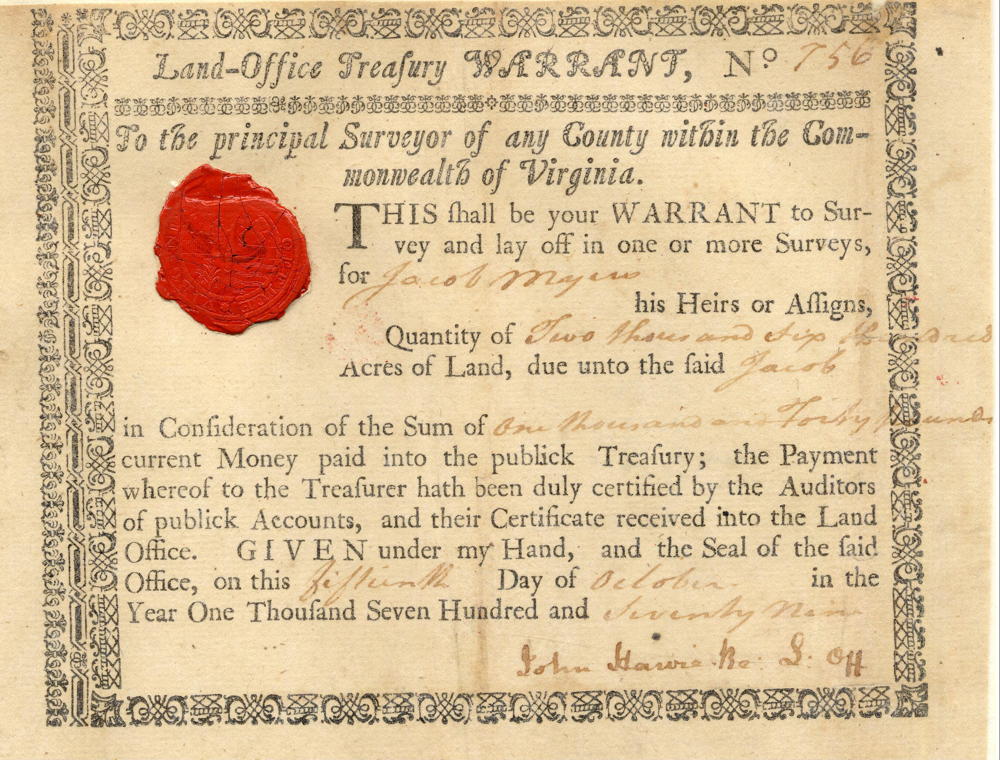
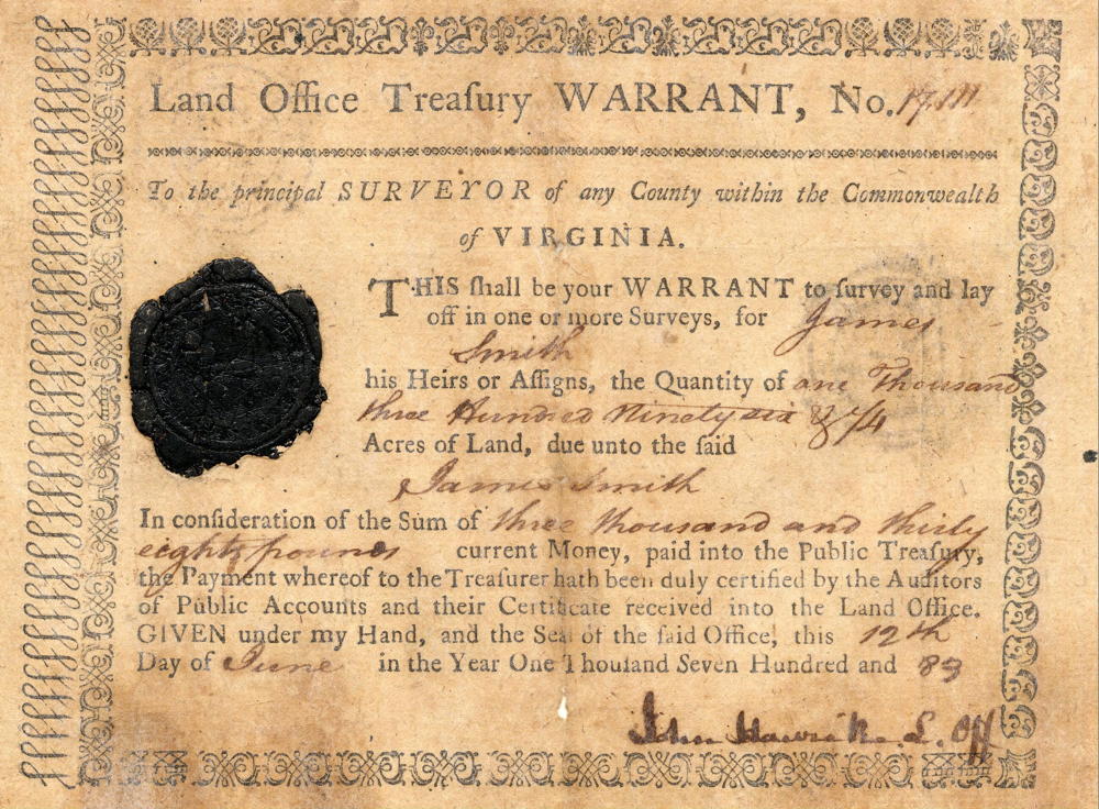
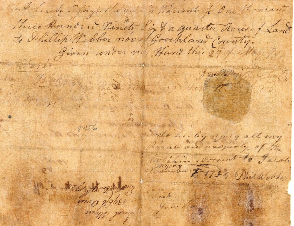
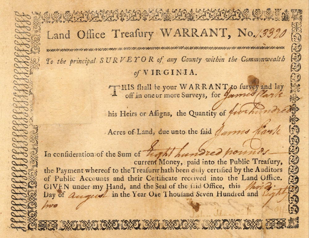
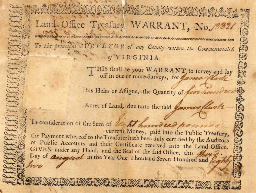
On 4 Nov 1790, Alexander Breckinridge, Jefferson County Surveyor, surveyed a tract of 5796.25 acres for Jacob Myers. This was the major piece in Myers' series of claims along the north side of Salt River downstream from Shepherdsville. It involved a number of treasury warrants to cover this huge claim. We've included images of these warrants near the bottom of this page.
Together, this tract and his 1000 acre tract and an additional 100 acre tract combined to stretch from his boundary with Jacob Froman's 1670 acre survey to the Salt River downstream from the mouth of the Rolling Fork River as shown on the drawing below. Also shown is an additional adjoining tract of 467.5 acres also claimed by Myers.
Survey
Survey
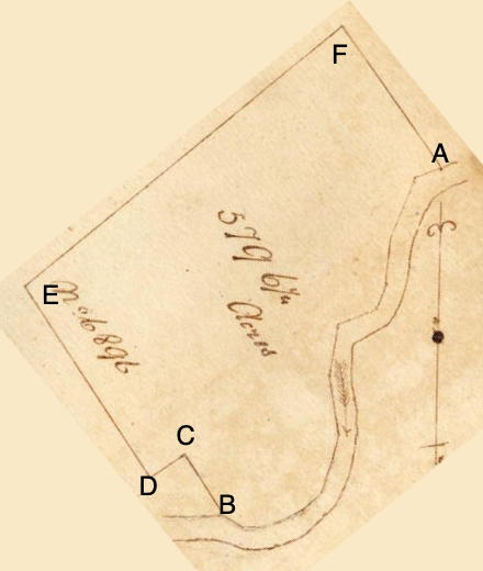
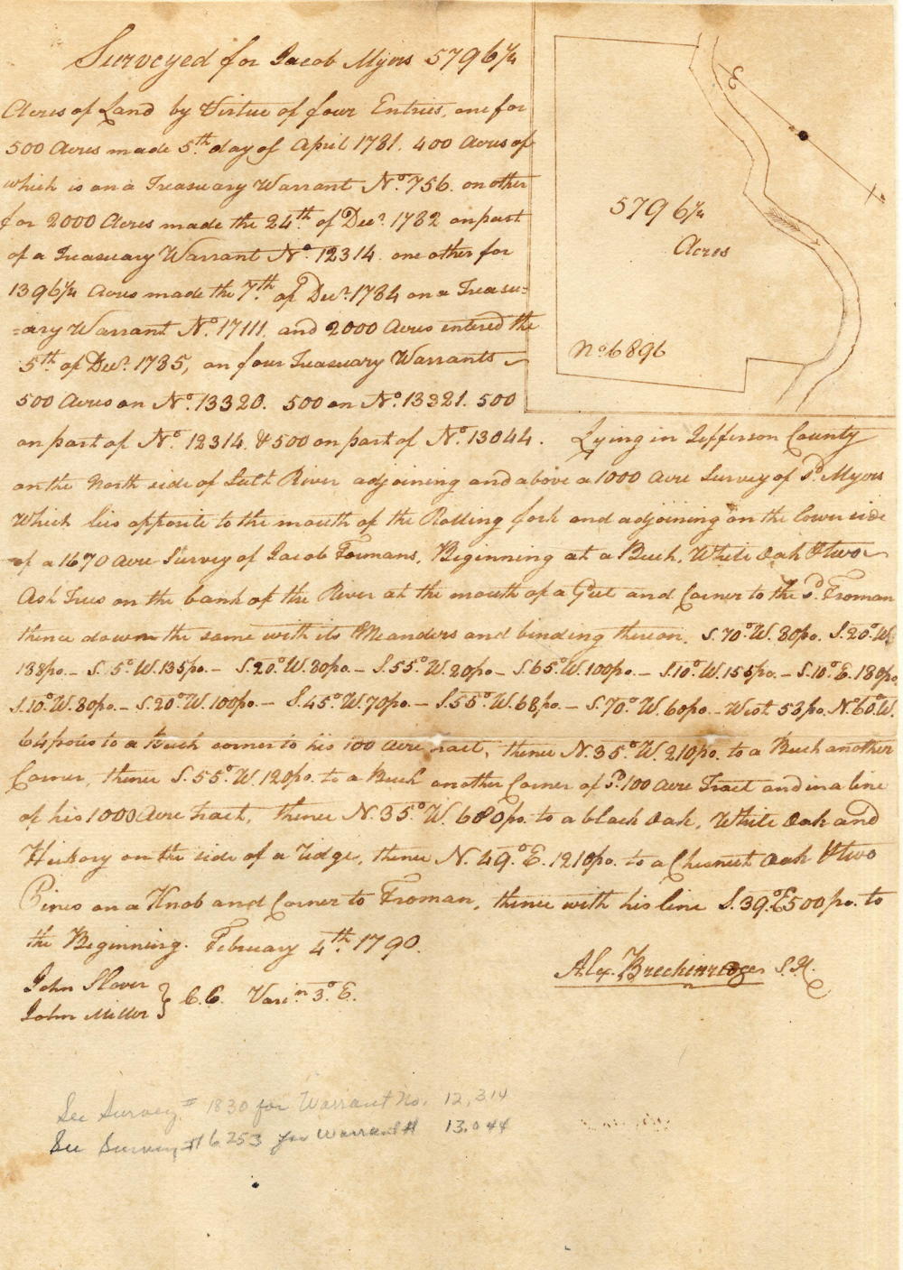
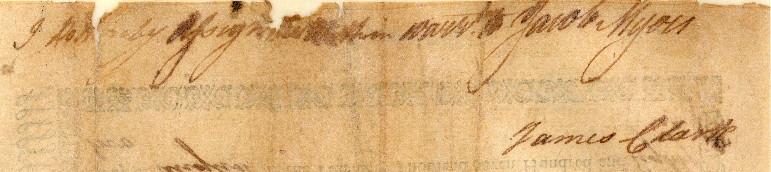
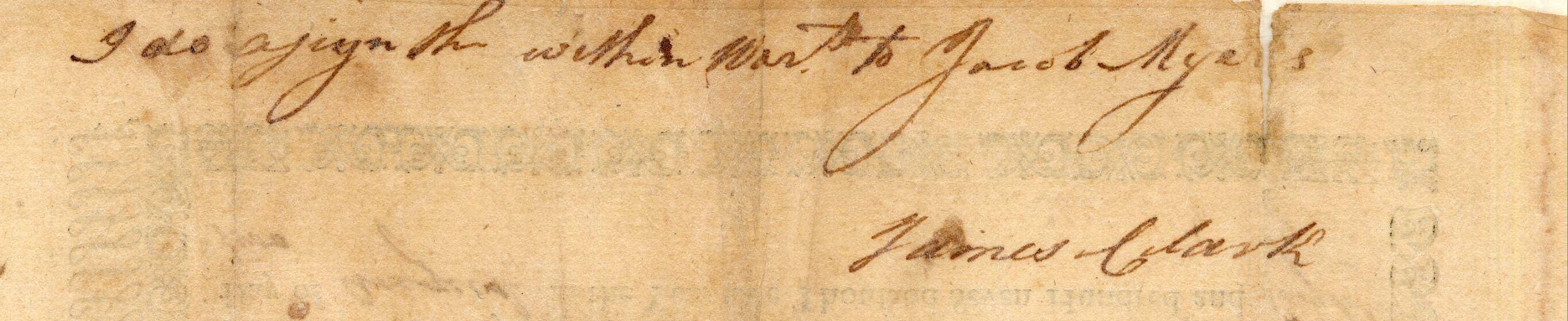
Surveyed for Jacob Myers 5796 1/4 acres of land by virtue of four entries, one for 500 acres made 5th day of April 1781, 400 acres of which is a treasury warrant No. 756, another for 2000 acres made the 24th of December 1782 on part of a treasury warrant No. 12314, one other for 1396 1/4 acres made the 7th of December 1784 on a treasury warrant No. 17111, and 2000 acres enter the 5th of December 1785 on four treasury warrants - 500 acres on No. 13320, 500 on No. 13321, 500 on part of No. 12314 & 500 on part of No. 13044. Lying in Jefferson County on the north side of Salt River adjoining and above a 1000 acre survey of said Myers which lies opposite to the mouth of the Rolling fork and adjoining on the lower side of a 1670 acre survey of Jacob Fromans. Beginning at [A] a beech, white oak & two ash trees on the bank of the river at the mouth of a gut and corner to the said Froman, thence down the same with its meanders and binding thereon S 70° W 80 poles, S 20° W 188 poles, S 5° W 135 poles, S 20° W 80 poles, S 55° W 20 poles, S 65° W 100 poles, S 10° W 155 poles, S 10° E 180 poles, S 10° W 80 poles, S 20° W 100 poles, S 45° W 70 poles, S 55° W 68 poles, S 70° W 60 poles, West 58 poles, N 60° W 64 poles to [B] a beech corner to his 100 acre tract, thence N 35° W 210 poles to [C] a beech another corner, thence S 55° W 120 poles to [D] a beech another corner of said 100 acre tract and in a line of his 1000 acre tract, thence N 35° W 680 poles to [E] a black oak, white oak and hickory on the side of a ridge, thence N 49° E 1210 poles to [F] a chesnut oak & two pines on a knob and corner to Froman, thence with his line S 39° E 500 poles to the beginning. February 4th 1790. Alexander Breckinridge SJC. Chain carriers: John Slover, John Milton
Deed
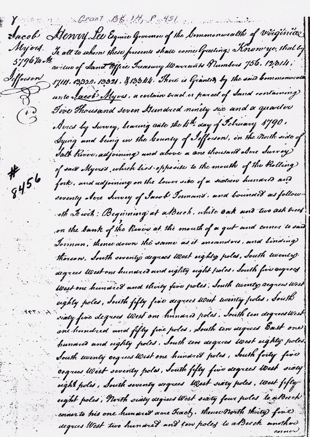
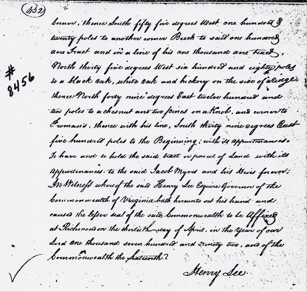
Virginia Grant Book 14, pages 451-2
Henry Lee Esquire, Governor of the Commonwealth of Virginia, to all to whom these presents shall come, greeting. Know ye that by virtue of land office treasury warrants Numbers 756, 12,314, 17111, 13320, 13321 & 13344 there is granted by the said Commonwealth unto Jacob Myers a certain tract or parcel of land containing five thousand seven hundred ninety six and a quarter acres by survey bearing date the 4th day of February 1790. Lying and being in the County of Jefferson on the north side of Salt River adjoining and above a one thousand acre survey of siad Myers's which lines opposite to the mouth of the Rolling fork, and adjoining on the lower side of a sixteen hundred and seventy acre survey of Jacob Froman's and bounded as followeth, to wit. Beginning at a beech, white oak and two ash trees on the bank of the river at the mouth of a gut and corner to said Froman, thence down the same as it meanders and binding thereon, South seventy degrees West eighty poles, South twenty degrees West one hundred and eighty eight poles, South five degrees West one hundred and thirty five poles, South twenty degrees West eighty poles, South fifty five degrees West twenty poles, South sixty five degrees West one hundred poles, South ten degrees West one hundred and fifty five poles, South ten degrees East one hundred and eighty poles, South ten degrees West eighty poles, South twenty degrees West one hundred poles, South forty five degrees West seventy poles, South fifty five degrees West sixty eight poles, South seventy degrees West sixty poles, West fifty eight poles, North sixty degrees West sixty four poles to a beech corner to his one hundred acre tract, thence North thirty five degrees West two hundred and ten poles to a beech another corner, thence South fifty five degrees West one hundred & twenty poles to another corner beech to said one hundred acre tract and in a line of his one thousand acre tract, North thirty five degrees West six hundred and eighty poles to a black oak, white oak and hickory on the side of a ridge, thence North forty nine degrees East twelve hundred and ten poles to a chesnut and two pines on a knob and corner to Froman's, thence with his line South thirty nine degrees East five hundred poles to the beginning with its appurtenances to have and to hold the said tract or parcel of land with its appurtenances to the said Jacob Myers and his heirs forever. In witness whereof the said Henry Lee Esquire, Governor of the Commonwealth of Virginia, hath hereunto set his hand and caused the lesser seal of the said Commonwealth to be affixed at Richmond on the thirteenth day of April in the year of our Lord one thousand seven hundred and ninety two, and of the Commonwealth the sixteenth. (signed) Henry Lee
Treasury Warrants
If you, the reader, have an interest in any particular part of our county history, and wish to contribute to this effort, use the form on our Contact Us page to send us your comments about this, or any Bullitt County History page. We welcome your comments and suggestions. If you feel that we have misspoken at any point, please feel free to point this out to us.
The Bullitt County History Museum, a service of the Bullitt County Genealogical Society, is located in the county courthouse at 300 South Buckman Street (Highway 61) in Shepherdsville, Kentucky. The museum, along with its research room, is open 10 a.m. to 4 p.m. Monday through Friday. Saturday appointments are available by calling 502-921-0161 during our regular weekday hours. Admission is free. The museum, as part of the Bullitt County Genealogical Society, is a 501(c)3 tax exempt organization and is classified as a 509(a)2 public charity. Contributions and bequests are deductible under section 2055, 2106, or 2522 of the Internal Revenue Code. Page last modified: 12 Sep 2024 . Page URL: bullittcountyhistory.org/bchistory/myers8456.html