
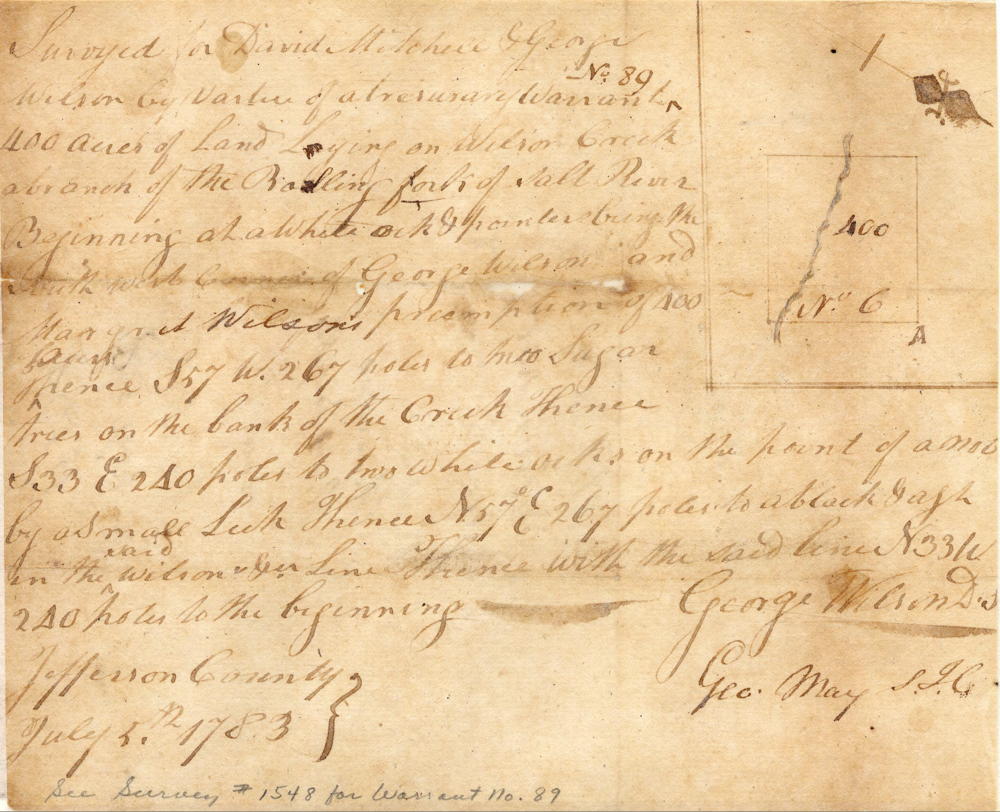
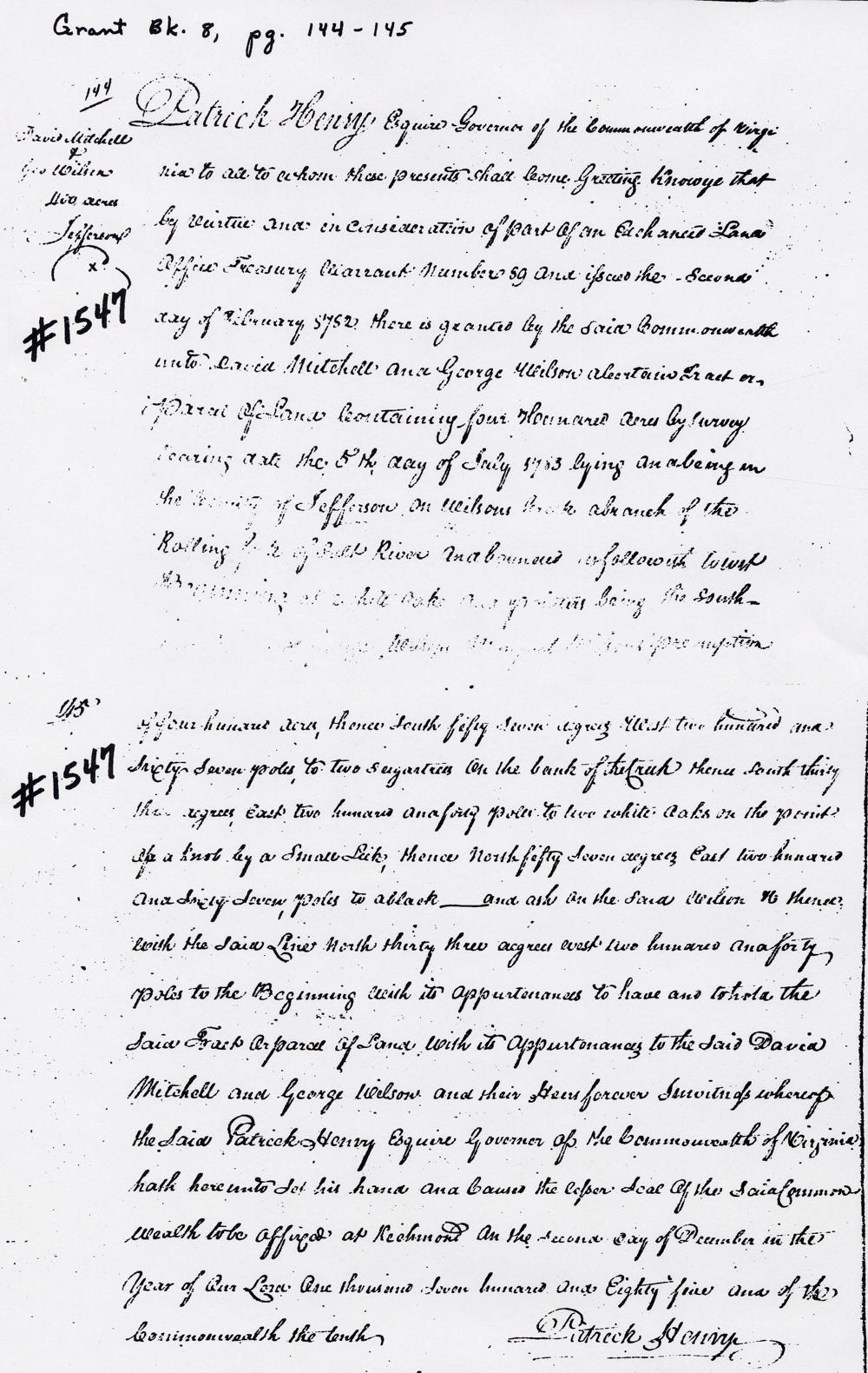
On 5 Jul 1783, George Wilson surveyed 400 acres on Wilson Creek in his and David Mitchell's names, and they received their deed on 2 Dec 1785. This was one of the earliest claims recorded along Bullitt County's southern border.
Survey

Surveyed for David Mitchell and George Wilson by virtue of a treasury warrant No. 89 to 400 acres of land line on Wilson Creek a branch of the Rolling Fork of Salt River. Beginning at a white oak & pointer(?) being the south west corner of George Wilson and Margaret Wilson's preemption of 400 acres, thence S 57 W 267 poles to two sugar trees on the bank of the creek, thence S 33 E 240 poles to two white oaks on the point of a knob by a small lick, thence N 57 E 267 poles to a black __ and ash in the said Wilson's line, thence with the said line N 33 W 240 poles to the beginning. Jefferson County, July 5th 1783. George Wilson, surveyor
Deed
Virginia Grant Book 8, pages 144-145
Patrick Henry Esquire, Governor of the Commonwealth of Virginia, to all to whom these presents shall come, greeting. Know ye that by virtue and in consideration of part of an Exchanged land office treasury warrant number 89 and issued the second day of February 1782, there is granted by the said Commonwealth unto David Mitchell and George Wilson a certain tract or parcel of land containing four hundred acres by survey bearing date the 5th day of July 1783, lying and being in the county of Jefferson on Wilson's Creek a branch of the Rolling Fork of Salt River, and bounded as follows, to wit. Beginning at a white oak & pointer(?) being the south west corner of George Wilson and Margaret Wilson's preemption of 400 acres, thence South 57° West 267 poles to two sugar trees on the bank of the creek, thence South 33° East 240 poles to two white oaks on the point of a knob by a small lick, thence North 57° East 267 poles to a black __ and ash in the said Wilson's line, thence with the said line North 33° West 240 poles to the beginning with its appurtenances to have and to hold the said tract or parcel of land, with its appurtenances to the said David Mitchell and George Wilson and their heirs forever. In witness whereof the said Patrick Henry Esquire, Governor of the Commonwealth of Virginia, hath hereunto set his hand and caused the lesser seal of the said Commonwealth to be affixed at Richmond on the second day of December in the year of our Lord one thousand seven hundred and eighty five and of the Commonwealth the tenth. (signed) Patrick Henry
If you, the reader, have an interest in any particular part of our county history, and wish to contribute to this effort, use the form on our Contact Us page to send us your comments about this, or any Bullitt County History page. We welcome your comments and suggestions. If you feel that we have misspoken at any point, please feel free to point this out to us.
The Bullitt County History Museum, a service of the Bullitt County Genealogical Society, is located in the county courthouse at 300 South Buckman Street (Highway 61) in Shepherdsville, Kentucky. The museum, along with its research room, is open 10 a.m. to 4 p.m. Monday through Friday. Saturday appointments are available by calling 502-921-0161 during our regular weekday hours. Admission is free. The museum, as part of the Bullitt County Genealogical Society, is a 501(c)3 tax exempt organization and is classified as a 509(a)2 public charity. Contributions and bequests are deductible under section 2055, 2106, or 2522 of the Internal Revenue Code. Page last modified: 12 Sep 2024 . Page URL: bullittcountyhistory.org/bchistory/mitchell-wilson.html