
In October 1860, Mary E. Crist agreed to a division of her life estate in the 360 acres she had received in a 1847 deed from William Newbolt which was to go to her remaining children, Mary Frances Roby, Alexander H. Crist and Laura C. Crenshaw. In return for deeding her life estate to her children, she was to receive yearly payments from them, and to also continue to live in her home, as shown in the deed transcribed below.
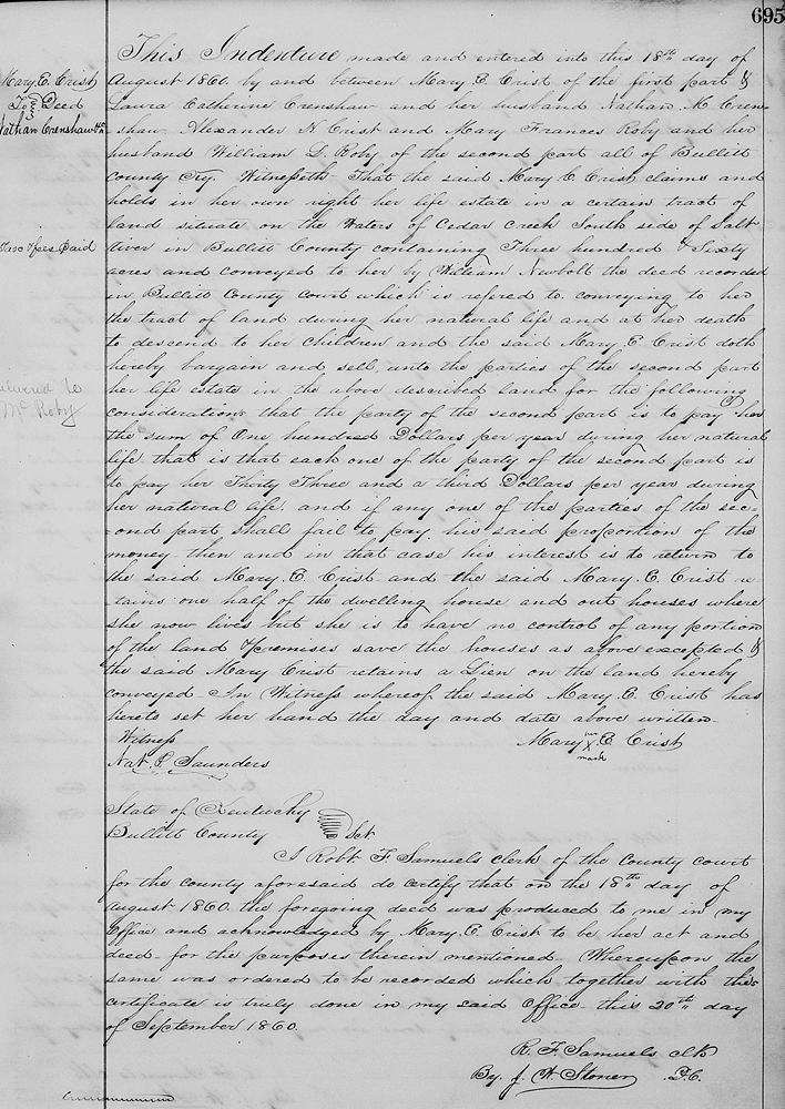
Bullitt County Deed Book O, Page 695
This indenture made and entered into this 18th day of August 1860 by and between Mary E. Crist of the first part and Laura Catherine Crenshaw and her husband, Nathan M. Crenshaw, Alexander H. Crist, and Mary Francis Roby and her husband William L. Roby of the second part all of Bullitt County Kentucky.
Witnesseth that the said Mary E. Crist claims and hold in her own right her life estate in a certain tract of land situate on the waters of Cedar Creek, south side of Salt River in Bullitt County, containing 360 acres, and conveyed to her by William Newbolt, the deed recorded in Bullitt County Court, which is referred to, conveying to her the tract of land during her natural life and her death to descend to her children, and the said Mary E Crist, doth hereby bargain and sell unto the parties of the second part her life estate in the above described land for the following consideration that the party of the second part is to pay her the sum of $100 per year during her natural life, that is that each one of the party of the second part is to pay her thirty-three and a third dollars per year during her natural life; and if any one of the parties of the second part shall fail to pay his said proportion of the money then and in that case his interest is to return to the said Mary E. Crist; and the said Mary E. Crist retains one-half of the dwelling house and out houses where she now lives, but she is to have no control of any portion of the land and premises, save the houses as above excepted; and the said Mary Crist retains a lien on the land hereby conveyed. In witness whereof the said Mary E. Crist has hereto set her hand the day and date above written. (signed) Mary [her x mark] E. Crist. Witness: Nat P. Saunders.
Her children petitioned the County Court to divide the land, and the report of that division was recorded in the Will Book F, as shown below.
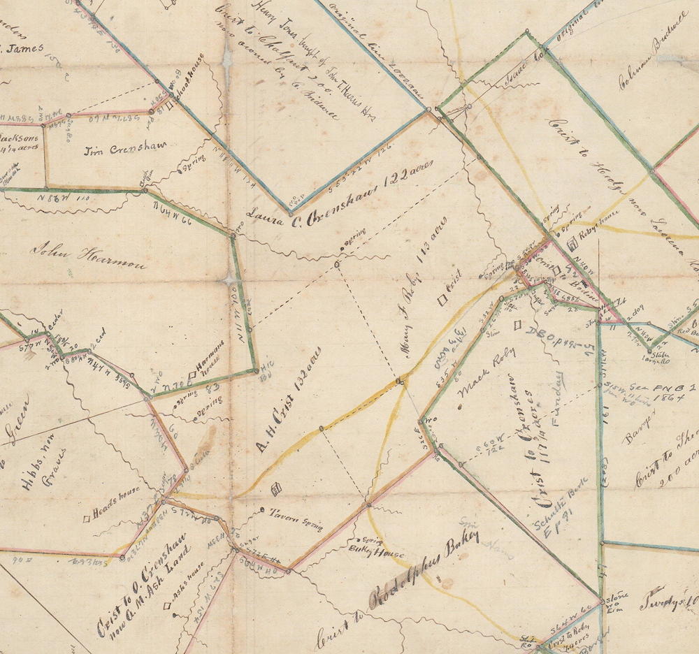
This land division can be seen more clearly on this clip from image 113-93 of the T. C. Carroll plat collection, shown here.
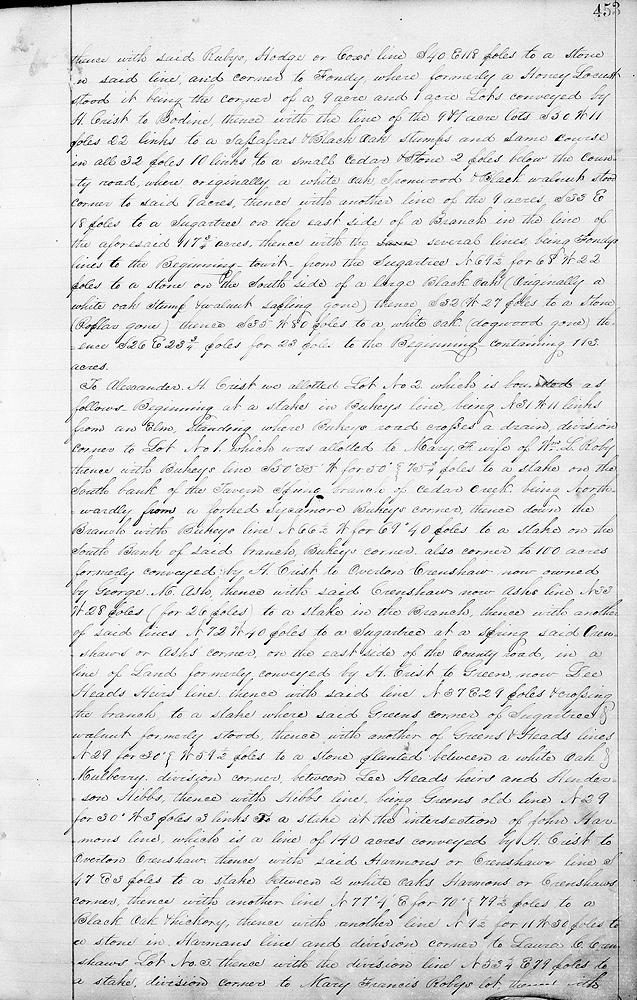
Bullitt County Will Book F, Pages 452-455
In obedience to an order of the Bullitt County Court, we the undersigned commissioners appointed by said court for the purpose of dividing the tract of land on which H. S. Crist, the deceased husband of Mary Crist, lived previous to, and at the time of his death; said tract of land is more generally known as the General Henry Crist tract on which he resided. Casper Herps, surveyor of Bullitt County, having previously surveyed said land, and according to the survey made out by him containing 376 acres we produced on the first day of October 1860, and in conjunction with the surveyor of Bullitt County, and after being first duly sworn, divided said land between the three heirs of said H. S. Crist, deceased, and Mary Crist, his wife as more fully shown and explained in the following boundaries, to wit.
To Mary Francis, wife of William L. Roby, and formerly a Crist, we allot lot #1 with the following boundary. Beginning at a stake in Bukey's line 5 poles from Bukey's corner where formerly a black oak and maple stood and corner to a 117 3/4 acre tract conveyed by Henry Crist to Rhoda Crenshaw and her children now, F. Fondy's corner, thence with Bukey's line S 50° 55' W (for 50°) 63 1/4 poles to a stake in said line, being N 31° W 11 links from an elm standing where Bukey's road crosses drain and division corner to Alexander H. Crist's Lot #2, thence with said line N 31° W 65 1/2 poles to a stone in the county road, thence with the road N 59° E 66 poles to a stake in the road, being S 42° E 1 pole, 14 links from a black gum standing on the north side of the road, thence N 28° W 95 poles to a stone, division corner to said A. H. Crist's lot in the division line of Lot #3 which is allotted to Nathan M. Crenshaw and Laura his wife, thence with the said division line of N 53 1/4° E 130 1/2 poles to a stone in Lawrence Roby line, being the same line of a tract of land conveyed by H. Crist to Hedge, and original line of Isaac Cox's 430 acre survey, thence with said Rubys, Hodge or Cox's line S 40° E 118 poles to a stone in said line and corner to Fondy where formerly a honey locust stood, it being the corner of a 9 acre and 1 acre lots conveyed by H. Crist to Bodine, thence with the line of the 9 and 1 acre lots S 50° W 11 poles, 22 links to a sassafras and black oak stumps, and same course in all 32 poles, 10 links to a small cedar and stone 2 poles below the county road where originally a white oak, ironwood and black walnut stood, corner to said 9 acres, thence with another line of the 9 acres S 33° E 18 poles to a sugar tree on the east side of a branch in the line of the aforesaid 117 3/4 acres, thence with the several lines, being Fondy's lines to the beginning, to wit from the sugar tree N 69 1/2° for 68° W 22 poles to a stone on the south side of a large black oak (originally a white oak stump and walnut sapling gone), thence S 32° W 27 poles to a stone (poplar gone), thence S 35° W 80 poles to a white oak (dogwood gone), thence S 26° E 23 3/4 poles for 23 poles to the beginning, containing 113 acres.
To Alexander H. Crist we allotted Lot #2 which is bounded as follows. Beginning at a stake in Bukey's line, being N 31° W 11 links from an elm standing where Bukey's road crosses a drain, division corner to Lot #1 which was allotted to Mary F., wife of William L. Roby, thence with Bukey's line S 50° 55' W (for 50°) 75 3/4 poles to a stake on the south bank of the Tavern Spring branch of Cedar Creek, being northwardly from a forked sycamore, Bukey's corner, thence down the branch with Bukey's line N 66 1/2° W (for 69°) 40 poles to a stake on the south bank of said branch, Bukey's corner, also corner to 100 acres formerly conveyed by H. Crist to Overton Crenshaw, now owned by George M. Ash, thence with said Crenshaw's, now Ash's line N 33° W 28 poles (for 26 poles) to a stake in the branch, thence with another of said lines N 72° W 40 poles to a sugar tree at a spring, said Crenshaw's or Ash's corner, on the east side of the county road, in a line of land formerly conveyed by H. Crist to Green, now Lee Head's heirs' line, thence with said line N 37° E 29 poles and crossing the branch to a stake where said Green's corner of sugar tree and walnut formerly stood, thence with another of Green's and Head's lines N 29° (for 30°) W 59 1/2 poles to a stone planted between a white oak and mulberry, division corner between Lee Head's heirs and Henderson Hibbs, thence with Hibbs' lin, being Green's old line, N 29° (for 30°) W 3 poles, 3 links to a stake at the intersection of John Harmon's line which is a line of 140 acres conveyed by H. Crist to Overton Crenshaw, thence with said Harmon's or Crenshaw's line S 47° E 3 poles to a stake between 2 white oaks, Harmon's or Crenshaw's corner, thence with another line N 77° 4' E (for 70°) 79 1/2 poles to a black oak and hickory, thence with another line N 9 1/2° (for 11°) W 30 poles to a stone in Harmon's line and division corner to Laura C. Crenshaw's Lot #3, thence with the division line N 53 1/4° E 79 poles to a stake, division corner to Mary Francis Roby's lot, thence with her line S 28° E 95 poles to a stake in the county road being S 42° E 1 pole 14 links from a black gum standing on the north side of the road, thence S 59° W 66 poles to a stone in the road, thence S 31° E 65 1/2 poles to the beginning - 132 acres.
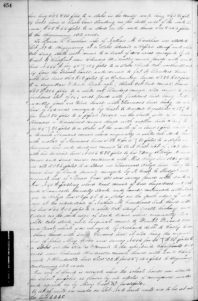
To Laura C. Crenshaw, wife of Nathan M. Crenshaw, we allotted Lot #3, beginning at a stake between a poplar stump and white oak snag, southwest corner to a tract of 200 acres conveyed by H. Crist to Chalfant, now Coleman Bridwell's corner, thence with said line N 44 1/4° W (for 45°) 124 poles to a stake and black oak, northwestwardly from the school house, and corner to James H. Landers, thence with his line S 50° W 19 poles to a persimmon, thence S 87 1/2° W 60 poles to a sugar tree and dead black oak (black oak true corner), thence S 69° W 20 1/2 poles to a white oak, Landers' corner, also corner to John Jackson's lot of 14 1/4 acres, thence with Jackson's line, being northwestwardly from an elm, thence wit hHarmon's line, being the old line of 140 acres conveyed by Crist to Overton Crenshaw, S 87 3/4° E (for East) 72 poles to a poplar and cedar on the south side of a branch, Harmon's or Crenshaw's corner, thence with another line S 61 3/4° E (for 64°) 72 poles to a stake at the mouth of a line, 1 pole south of a branch, Harmon's corner where originally a white oak stood, thence with another of Harmon's lines S 9 1/2° (for 11°) E 70 poles to a stake in Harmon's line and division corner to A. H. Crist, lot #2, thence with his division line N 53 1/4° E 79 poles to his and Mary F. Roby's division corner and same course continued with Mrs. Roby's line 130 1/2 poles in all 209 1/2 poles to a stone in Lawrence Roby's line, being the same line of land formerly conveyed by H. Crist to Hedge, and orignial line of Isaac Cox's 430 acre survey, thence with said line N 40° W passing where Cox's corner of 3 sugar trees, red oak and ironwood formerly stood, and course continued with Hedge's or Roby's line 39 poles 4 links to a stake on the south edge of a drain at the intersection of Nathan M. Crenshaw's line, thence with his line S 64° W 5 1/2 poles to a white oak stump, small hickory and cedar on the north edge of said drain where originally two white oaks stood and original corner to Daniel Devore's 255 acre tract which was conveyed by Richard Bibb to Cosby Crenshaw, thence with said Devore's line, it also being the original line of Joh May's 2000 acre survey N 44 1/2° (for 45°) W 9 1/4 poles to a stone in the glade and corner to the aforesaid Chalfant's 200 acres, now Coleman Bridwell's corner, thence with said Chalfant's and Bridwell's line S 53° 22' W (for 52°) 126 poles to be beginning, containing 122 acres.
One acre of land is reserved where the school house now stands for school purposes as shown by an article of conveyance made and agreed on by Mary Crist &c heretofore.
A lot of rails are made on lot #3, said rails are to be set on the line A.B.A.C.
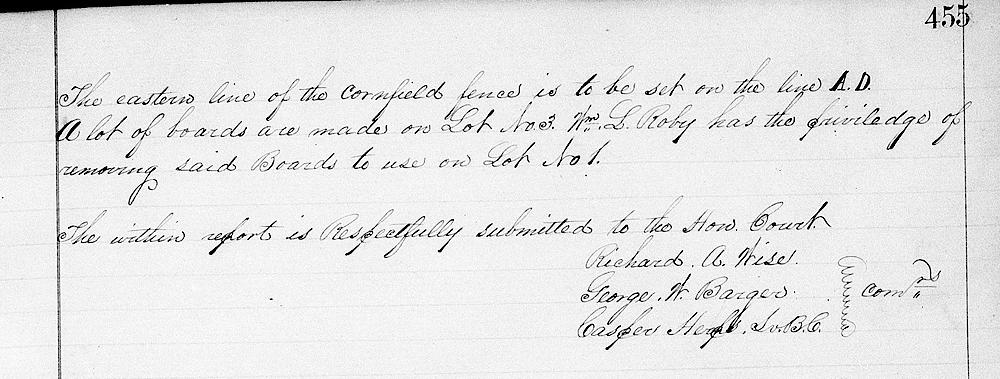
The eastern line of the cornfield fence is to be set on the line A.D.
A lot of boards are made on lot #3. William L. Roby has the privilege of removing said boards to use on lot #1.
The within report is respectfully submitted to the honorable court. (signed) Commissioners Richard A. Wise, George W. Barger, Casper Herps, Bullitt County Surveyor

If you, the reader, have an interest in any particular part of our county history, and wish to contribute to this effort, use the form on our Contact Us page to send us your comments about this, or any Bullitt County History page. We welcome your comments and suggestions. If you feel that we have misspoken at any point, please feel free to point this out to us.
The Bullitt County History Museum, a service of the Bullitt County Genealogical Society, is located in the county courthouse at 300 South Buckman Street (Highway 61) in Shepherdsville, Kentucky. The museum, along with its research room, is open 10 a.m. to 4 p.m. Monday through Friday. Saturday appointments are available by calling 502-921-0161 during our regular weekday hours. Admission is free. The museum, as part of the Bullitt County Genealogical Society, is a 501(c)3 tax exempt organization and is classified as a 509(a)2 public charity. Contributions and bequests are deductible under section 2055, 2106, or 2522 of the Internal Revenue Code. Page last modified: 04 Sep 2025 . Page URL: bullittcountyhistory.org/bchistory/newbolt-marycrist.html