
On 14 Aug 1799, John and Susanna Edwards received $1500 from Samuel Thornsberry as payment for 500 acres out of Edwards' 1500 acre tract along Cedar Creek, a branch of Floyd's Fork. On 24 June 1800, Edwards sold another 378 acres of his patent to Thornsberry for a payment of $756. Then, on 4 Nov 1802, Edwards sold some more land to Thornsberry, this time 218 acres at a cost of $300. Parts of all three deeds are transcribed below, with images of the deeds following each transcription.
Samuel Thornberry transferred ownership of 200 acres to his son Seth B. Thornberry on 24 Jan 1813.
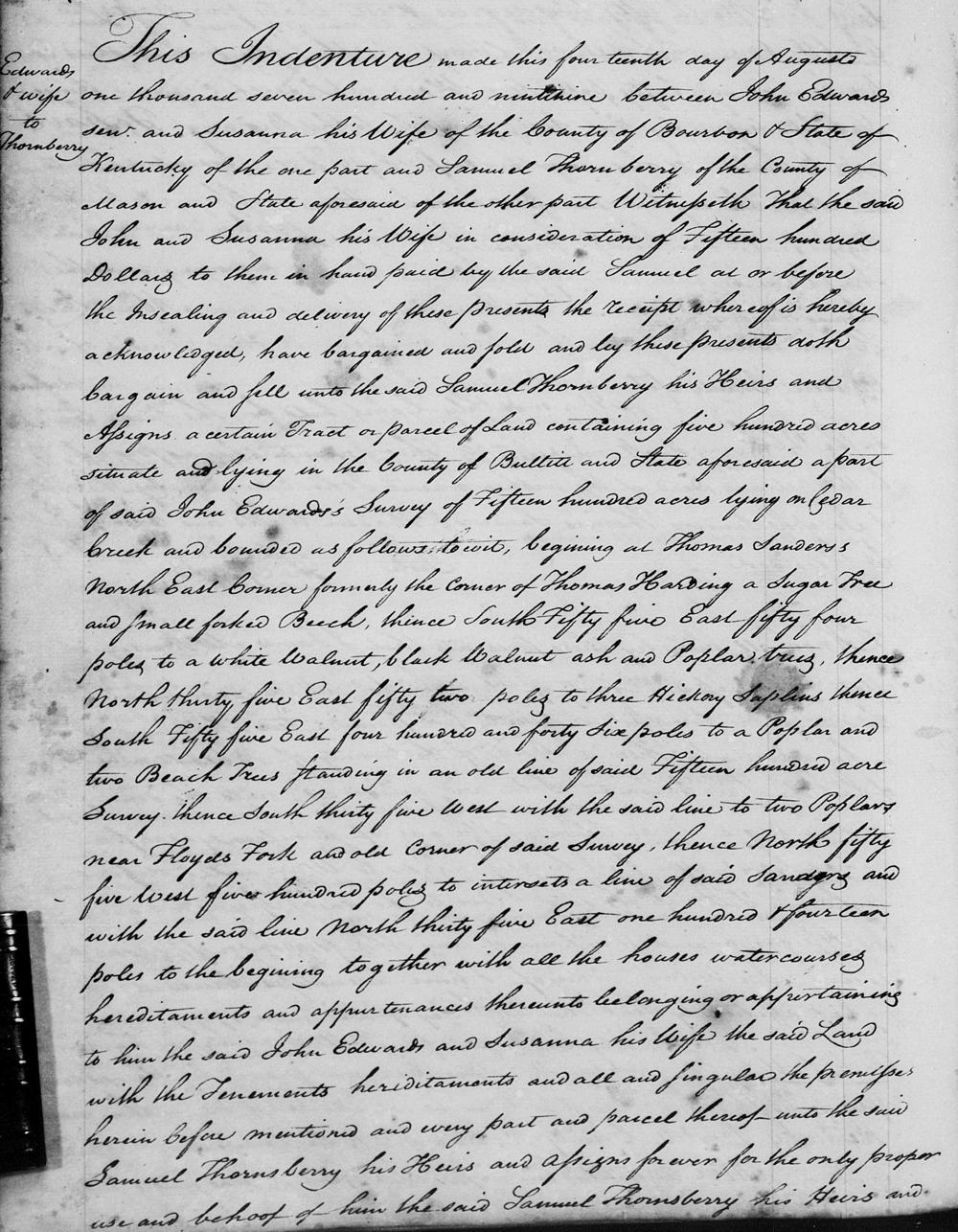
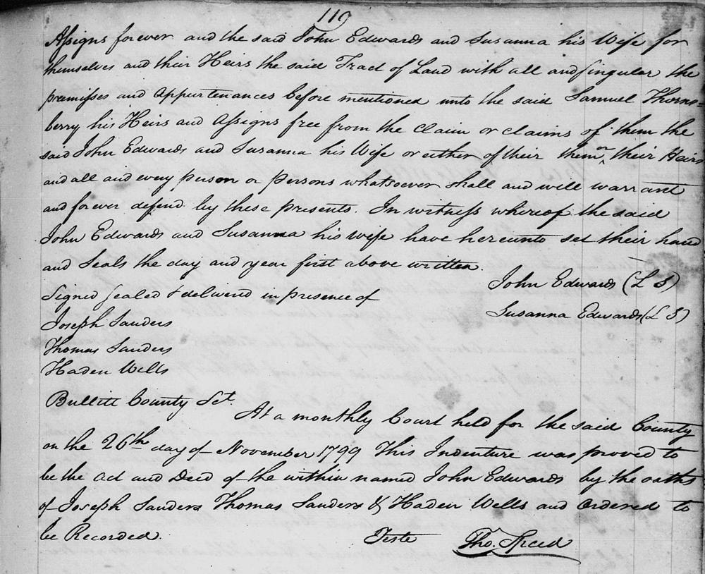
Bullitt County Deed Book A, pages 118-119
This indenture made this fourteenth day of August, one thousand seven hundred and ninety-nine between John Edwards Senior and Susanna his wife of the County of Bourbon & State of Kentucky of the one part and Samuel Thornsberry of the County of Mason and State aforesaid of the other part. Witnesseth tht the said John and Susanna his wife in consideration of fifteen hundred dollars to them in hand paid by the said Samuel at or before the insealing and delivery of these presents, the receipt whereof is hereby acknowledged, have bargained and sold and by these presents doth bargain and sell unto the said Samuel Thornsberry, his heirs and assigns a certain tract or parcel of land containing five hundred acres situate and lying in the County of Bullitt and State aforesaid a part of said John Edward's survey of fifteen hundred acres lying on Cedar Creek and bounded as follows, to wit, beginning at Thomas Sanders northeast corner, formerly the corner of Thomas Harding, a sugar tree and small forked beech, thence South fifty five East fifty four poles to a white walnut, black walnut, ash, and poplar trees, thence North thirty five East fifty two poles to three hickory saplings, thence South fifty five East four hundred and forty six poles to a poplar and two beech trees standing in an old line of said fifteen hundred acre survey, thence South thirty five West with the said line to two poplars near Floyd's Fork and old corner of said Survey, thence North fifty five West five hundred poles to interset a line of said Sanders and with the said line North thirty five East one hundred & fourteen poles to the beginning, together with all the houses, watercourses, hereditaments and appurtenances thereunto belonging or appertaining to him the said John Edwards and Susanna his wife the said land with the tenements, hereditaments and all and singular the premises herein before mentioned and every part and parcel thereof unto the said Samuel Thornsberry his heirs and assigns forever for the only proper use and behoof of him the said Samuel Thornsberry, his heirs and assigns forever, and the said John Edwards and Susanna his wife for themselves and their heirs the said tract of land with all and singular the premises and appurtenance before mentioned unto the said Samuel Thornsberry, his heirs and assigns free from the claim or claims of them the said John Edwards and Susanna his wife or either of them or their heirs and all and every person or persons whatsoever shall and will warrant and forever defend by these presents. In witness whereof the said John Edwards and Susanna his wife have hereunto set their hand and seals the day and year first above written. (signed) John Edwards, Susanna Edwards. Signed, sealed and delivered in presence of Joseph Sanders, Thomas Sanders, Haden Wells.
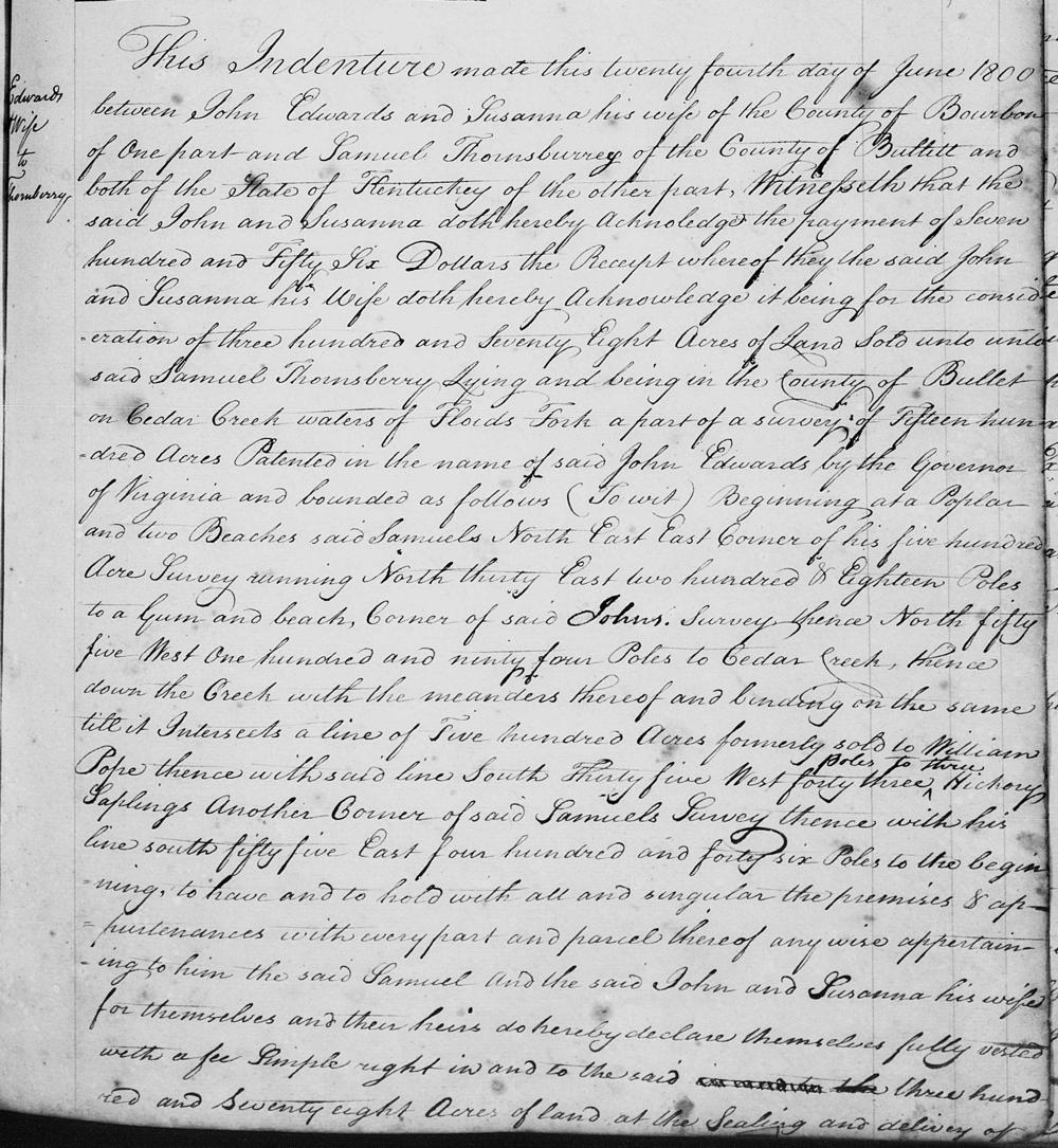
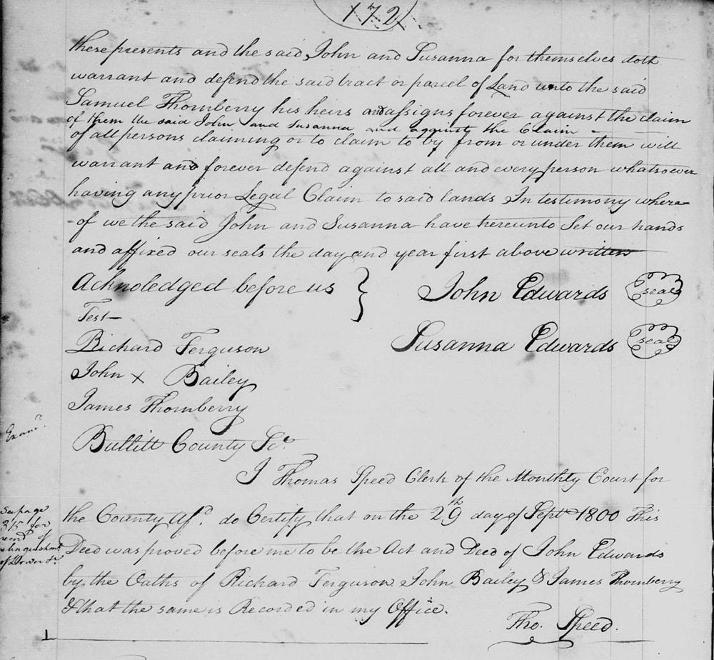
Bullitt County Deed Book A, pages 171-2
This indenture made this 24th day of June 1800, between John Edwards and Susanna his wife of the County of Bourbon of the one part and Samuel Thornberry of the County of Bullitt and both of the state of Kentucky of the other part. Witnesseth tht the said John and Susanna doth hereby acknowledge the payment of $756, the receipt whereof they the said John and Susanna his wife doth hereby acknowledge, it being for the consideration of 378 acres of land sold unto the said Samuel Thornberry, lying and being in the county of Bullitt on Cedar Creek waters of Floyd's Fork, a part of a survey of 1500 acres patented in the name of said John Edwards by the governor of Virginia, and bounded as follows (to wit). Beginning at a poplar and two beeches, said Samuel's north east corner of his five hundred acre survey, running North 30° East 218 poles to a gum and beech, corner of said John's survey, thence North 55° West 194 poles to Cedar Creek, thence down the creek with the meanders thereof and binding on the same till it intersects a line of 500 acres formerly sold to William Pope, thence with said line South 35° West 43 poles to three hickory saplings, another corner of said Samuel's survey, thence with his line South 55° East 446 poles to the beginning, to have and to hold with all and singular the premises & appurtenances with every part and parcel thereof any wise appertaining to him the said Samuel, and the said John and Susanna his wife for themselves and their heirs do hereby declare themselves fully vested with a fee simple right in and to the said 378 acres of land at the sealing and delivery of these presents and the said John and Susanna for themselves doth warrant and defend the said tract or parcel of land unto the said Samuel Thornberry, his heirs and assigns forever against the claim of them the said John and Susanna and against the claim of all persons claiming or to claim to by from or under them will warrant and forever defend against all and every person whatsoever having any prior legal claim to said lands. In testimony whereof we the said John and Susanna have hereunto set our hands and affixed our seals the day and year first above written. (signed) John Edwards; Susanna Edwards. Acknowledged before us, teste: Richard Ferguson, John (X) Bailey, James Thornberry.
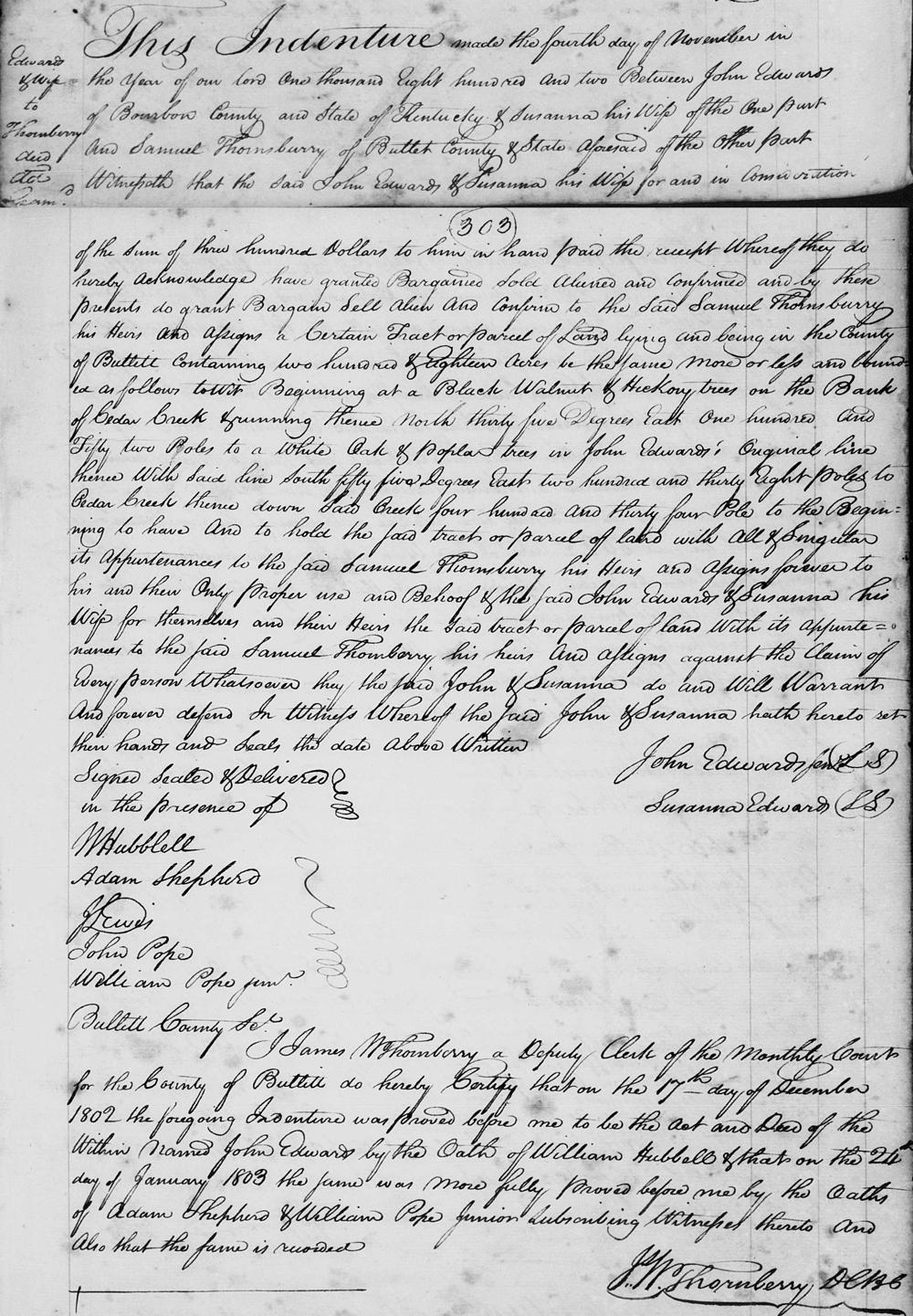
Bullitt County Deed Book A, pages 302-3
This indenture made the fourth day of November and the year of our Lord 1802 between John Edwards of Bourbon county and state of Kentucky and Susanna his wife of the one part and Samuel Thornsberry of Bullitt County state aforesaid of the other part. Witnesseth that the said John Edwards & Susanna his wife, for and in consideration of the sum of $300 to him in hand paid, the receipt whereof they do hereby acknowledge, have granted, bargained, sold, aliened and confirmed and by these presents do grant, bargain, sell, alien and confirm to the said Samuel Thornsberry, his heirs and assigns, a certain tract or parcel of land lying and being in the county of Bullitt containing 218 acres, be the same more or less, and bounded as follows, to wit. Beginning at a black walnut and hickory trees on the bank of Cedar Creek and running thence North 35° East 152 poles to a white oak and poplar trees in John Edward's original line, thence with said line South 55° east 238 poles to Cedar Creek, thence down said creek 434 poles to the beginning, to have and to hold the said tract or parcel of land with all & singular its appurtenances to the said Samuel Thornsberry, his heirs and assigns forever to his and their only proper use and behoof of the said John Edwards & Susanna his wife for themselves and their heirs the said tract or parcel of land with its appurtenances to the said Samuel Thornberry, his heir and assigns against the claim of every person whatsoever, they the said John & Susanna do and will warrant and forever defend. In witness whereof the said John & Susanna hath hereto set their hands and seals the date above written. (signed) John Edwards, Susanna Edwards. Signed, sealed and delivered in the presence of W. Hubblell, Adam Shepherd, J. Lewis, John Pope, William Pope Jr.
If you, the reader, have an interest in any particular part of our county history, and wish to contribute to this effort, use the form on our Contact Us page to send us your comments about this, or any Bullitt County History page. We welcome your comments and suggestions. If you feel that we have misspoken at any point, please feel free to point this out to us.
The Bullitt County History Museum, a service of the Bullitt County Genealogical Society, is located in the county courthouse at 300 South Buckman Street (Highway 61) in Shepherdsville, Kentucky. The museum, along with its research room, is open 10 a.m. to 4 p.m. Monday through Friday. Saturday appointments are available by calling 502-921-0161 during our regular weekday hours. Admission is free. The museum, as part of the Bullitt County Genealogical Society, is a 501(c)3 tax exempt organization and is classified as a 509(a)2 public charity. Contributions and bequests are deductible under section 2055, 2106, or 2522 of the Internal Revenue Code. Page last modified: 04 Sep 2025 . Page URL: bullittcountyhistory.org/bchistory/johnedwards_to_thornsberry.html