
Hugh Caldwell of Bullitt County and John Hunter of Wheeling, Virginia sold "two eighths" of their joint Bullitt County holdings to John C. Tarr of Brook County, Virginia. Individually they would later sell the lands to William Patterson. The deed below describes Hunter's sale to Tarr.
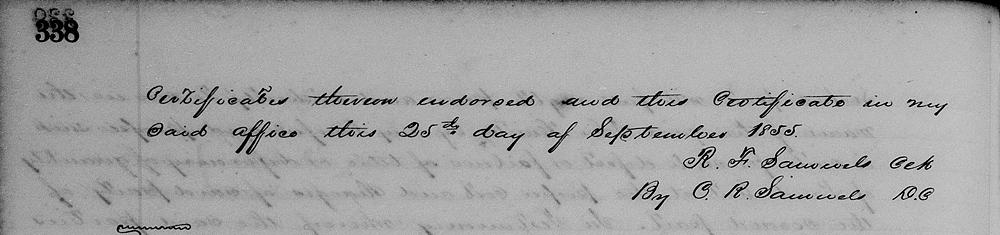
Bullitt County Deed Book N, Pages 334-338
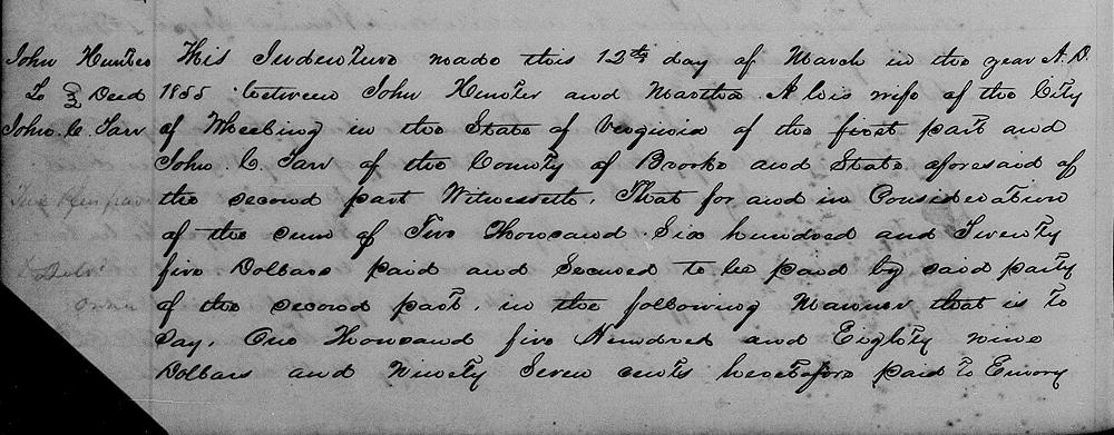
This indenture made this 12th day of March in the year A.D. 1855 between John Hunter and Martha A. his wife of the City of Wheeling in the State of Virginia of the first part and John C. Tarr of the County of Brooke and State aforesaid of the second part. Witnesseth that for and in consideration of the sum of $5625 paid and secured to be paid by said party of the second part in the following manner, that is to say, $1589.97 heretofore paid to Emory Low in his lifetime and to his representatives once his decease, and the further sum of $1035.03 paid or satisfactorily secured to be paid to the said representatives of Emory Low deceased or to William Patterson of Bullitt County in the State of Kentucky, or to whichever it shall appear equitable and right, the same shall be paid with interest thereon from the first January 1851 till paid.
They the said parties of the first part do grant, bargain, sell and convey unto the said party of the second part and his heirs the undivided eight part of all and singular the four several tracts of land situated in said County of Bullitt in said State of Kentucky.
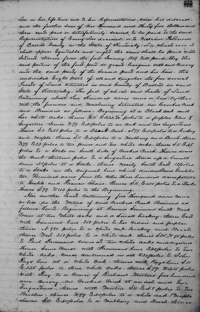
The first of which said tracts of land containing about 200 acres more or less, together with the furnace and machinery situated on the waters of Crooked Creek and bounded as follows.
Beginning at a black oak & two white oaks, thence N 11° W 324.6 poles to a poplar, elm and sugar tree, thence N 79° E 40 poles to an oak and two sugar trees, thence S 11° E 48 poles to a beech, N 79° E 40 poles to a hickory and maple, thence S 11° E 40 poles to a mulberry and beech, thence N 79° E 33 poles to two pines and two white oaks, thence S 11° E 48 poles to a stake on the south side of Crooked Creek, thence down the creek 13 poles to a sugar tree, thence up a small drain 48 poles to a stake, thence nearly southeast 18 poles to a stake on the original line which divides David Grable's 200 acres from the other 300 patented to Grable and Francis Shain, thence S 11° E 140 poles to a stake, thence S 79° W 113 poles to the beginning.
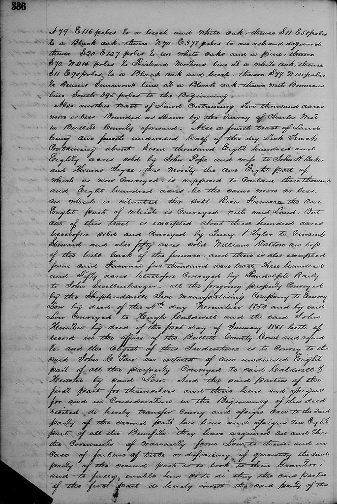
Also another tract containing 5000 acres more or less on the waters of said Crooked Creek, bounded as follows to wit. Beginning at Dennis Simmons' southwest corner at two white oaks and small hickory, thence East with Simmons' line 850 poles to two cedars and poplar, thence North 980 poles to a white oak and hickory and beech, thence West 350 poles to a white oak, thence S 85° W 75 poles to Paul Froman's corner at two white oaks and a dogwood, thence same course with Froman's line 320 poles to two white oaks course continued in all 630 poles to John Ray's line at a white oak, thence with Ray's line S 11° E 125 poles to three white oaks, thence S 79° W 215 poles with Ray to a corner of Richard Morton's 500 acre survey on Crooked Creek, at an ash and two sugar trees, thence with Morton S 11° E 48 poles to two beeches, thence N 79° E 40 poles to a white oak and maple, thence S 11° E 40 poles to a mulberry and beech, thence N 79° E 116 poles to a beech and white oak, thence S 11° E 50 poles to a black oak, thence N 70° E 378 poles to an oak and dogwood, thence S 20° E 127 poles to two white oaks and a pine, thence S 70° W 215 poles to Richard Morton's line at a white oak, thence S 11° E 90 poles to a black oak and beech, thence S 79° W 100 poles to Dennis Simmons' line at a black oak, thence with said Bowman's South 395 poles to the beginning.
Also another tract of land containing 2000 acres more or less bounded as shown by the survey of Charles West in Bullitt County aforesaid.
Also a fourth tract of land being one undivided half of the Dry Lick tract, containing about 7880 acres sold by John Pope and wife to John H. Baker and Thomas Joyce, this moiety the one eight part of which as now conveyed is supposed to contain 3800 acres, be the same more or less, on which is situated the Salt River Furnace the one eight part of which is conveyed with said land, but out of this tract is excepted about 300 acres heretofore sold and conveyed by Quirey and Tyler to Vincent Steward, and also fifty acres sold William Dalton on top of the hill back of the furnace, and there is also excepted said 5000 acre tract 350 acres heretofore conveyed by Randolph Railey to John Snellenbarger.
All of the foregoing property conveyed by the Shepherdsville Iron Manufacturing Company to Emory Low by deed of the 4th of November 1850, and by the said Low conveyed to Hugh Caldwell and the said John Hunter by deed of the 1st of January 1851, both of record in the office of the Bullitt County Court and referred to and the object of this indenture is to convey to the said John C. Tarr an interest of one undivided eight part of all the property conveyed to said Caldwell and Hunter by said Low.
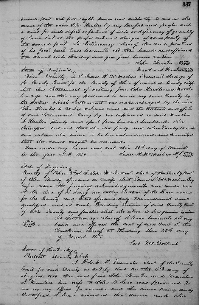
And the said parties of the first part for themselves and their heirs and assigns for and in consideration in the beginning of this deed recited do hereby transfer, convey and assign over to the said party of the second part, his heirs and assigns one eight part of all the benefits they have acquired on and through the covenants of warranty from Low to them, and in case of failure of title or deficiency of quantity the said party of the second part is to look to their grantor and to fully enable him fully to do so, they the said parties of the first part do hereby invest the said party of the second part with full right, power and authority to sue in the name of the said John Hunter by any lawful or proper suit or suits for such defect or failure of title or deficiency in quantity of land but at the proper costs and charges of said party of the second part.
In testimony whereof the said parties of the first part have hereunto set their hands and affixed their several seals this day and year first herein written.
(signed) John Hunter, Martha A. Hunter
The Bullitt County History Museum, a service of the Bullitt County Genealogical Society, is located in the county courthouse at 300 South Buckman Street (Highway 61) in Shepherdsville, Kentucky. The museum, along with its research room, is open 10 a.m. to 4 p.m. Monday through Friday. Saturday appointments are available by calling 502-921-0161 during our regular weekday hours. Admission is free. The museum, as part of the Bullitt County Genealogical Society, is a 501(c)3 tax exempt organization and is classified as a 509(a)2 public charity. Contributions and bequests are deductible under section 2055, 2106, or 2522 of the Internal Revenue Code. Page last modified: 12 Apr 2026 . Page URL: bullittcountyhistory.org/bchistory/hunter-tarr.html