
Hugh Caldwell of Bullitt County and John Hunter of Wheeling, Virginia sold "two eighths" of their joint Bullitt County holdings to John C. Tarr of Brook County, Virginia. Individually they would later sell the lands to William Patterson. The deed below describes the three-eighths sold by Caldwell to Patterson.
Bullitt County Deed Book N, Pages 205-209
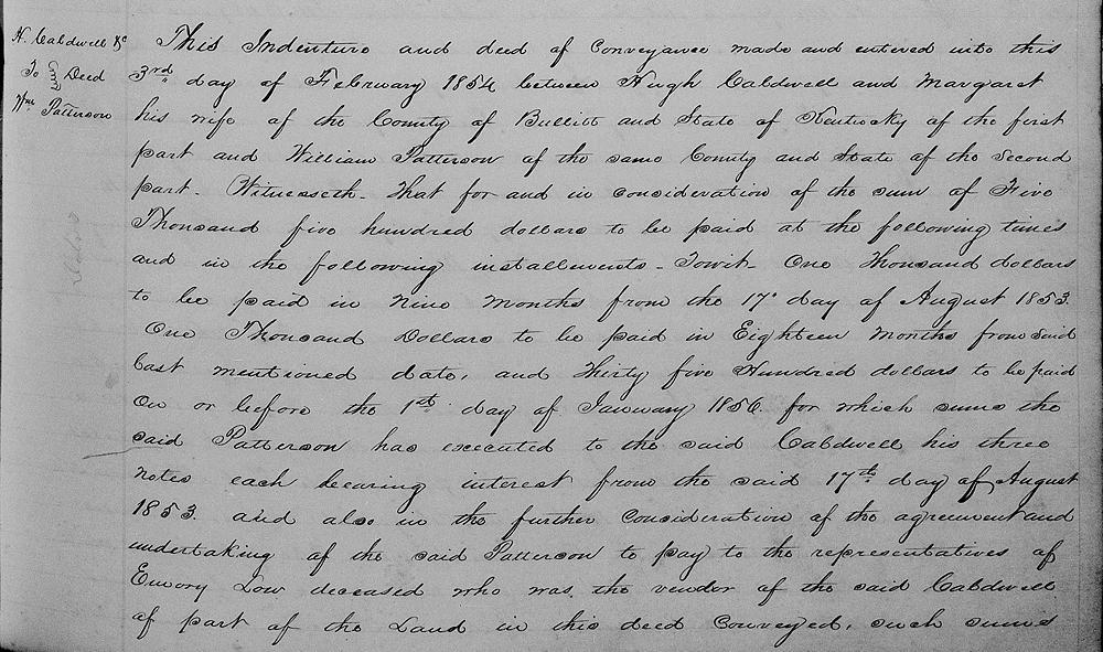
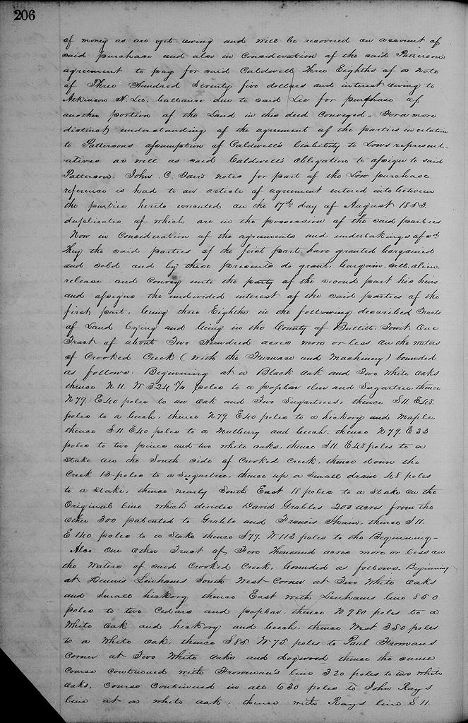
This indenture and deed of conveyance made and entered into this 3rd day of February 1854 between Hugh Caldwell and Margaret his wife of the County of Bullitt and State of Kentucky of the first part and William Patterson of the same county and state of the second part. Witnesseth that for and in consideration of the sum of $5,500 to be paid at the following times and in the following installments, to wit: $1000 to be paid in nine months from the 17th day of August 1853, $1000 to be paid in 18 months from said last mentioned date, and $3500 to be paid on or before the 1st day of January 1856, for which sum the said Patterson has executed to the said Caldwell his three notes, each bearing interest from the said 17th day of August 1853; and also the further consideration of the agreement and undertaking of the said Patterson to pay to the representatives of Emory Low deceased who was the vendor of the said Caldwell of part of the land in this deed conveyed, such sum of money as are yet owing and will be recovered on account of said purchase; and also in consideration of the said Patterson's agreement to pay for said Caldwell three eighths of a note of $375 and interest owing to Atkinson H. Lee, balance due to said Lee for purpose of another portion of the land in this deed conveyed. For a more distinct understanding of the agreement of the parties in relation to Patterson's assumption of Caldwell's liability to Low's representative, as well as said Caldwell's obligation to assignee to said Patterson, John C. Tarr's notes for part of the Low purchase, reference is had to an article of agreement entered into between the parties hereto executed on the 17th day of August 1853, duplicates of which are in the possession of the said parties.
Now in consideration of the agreements and undertakings aforesaid, they the said parties of the first part have granted, bargained and sold and by these presents do grant, bargain, sell, alien, release and convey unto the party of the second part, his heirs and assigns, the undivided interest of the said parties of the first part, being three eighths in the following described tracts of land lying and being in the County of Bullitt, to wit.
One tract of about 200 acres more or less on the waters of Crooked Creek (with the furnace and machinery) bounded as follows.
Beginning at a black oak & two white oaks, thence N 11° W 324.5 poles to a poplar, elm and sugar tree, thence N 79° E 40 poles to an oak and two sugar trees, thence S 11° E 48 poles to a beech, thence N 79° E 40 poles to a hickory and maple, thence S 11° E 40 poles to a mulberry and beech, thence N 79° E 33 poles to two pines and two white oaks, thence S 11° E 48 poles to a stake on the south side of Crooked Creek, thence down the creek 13 poles to a sugar tree, thence up a small drain 48 poles to a stake, thence nearly southeast 18 poles to a stake on the original line which divides David Grable's 200 acres from the other 300 patented to Grable and Francis Shain, thence S 11° E 140 poles to a stake, thence S 79° W 113 poles to the beginning.
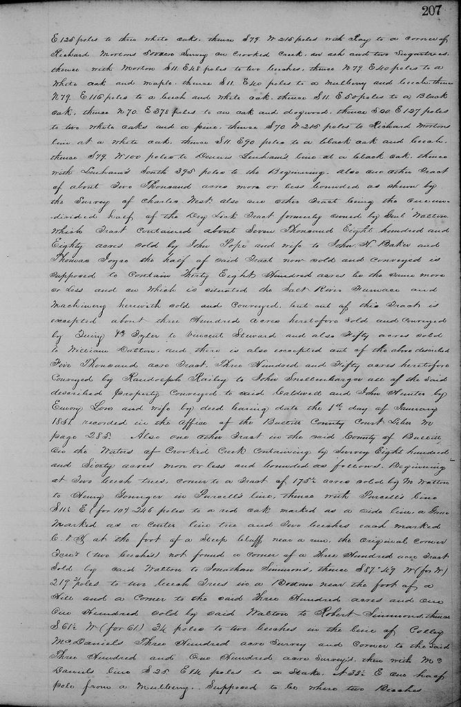
Also one other tract of 5000 acres more or less on the waters of said Crooked Creek, bounded as follows Beginning at Dennis Lenham's southwest corner at two white oaks and small hickory, thence East with Lenham's line 850 poles to two cedars and poplar, thence North 980 poles to a white oak and hickory and beech, thence West 350 poles to a white oak, thence S 85° W 75 poles to Paul Froman's corner at two white oaks and a dogwood, thence the same course continued with Froman's line 320 poles to two white oaks course continued in all 630 poles to John Ray's line at a white oak, thence with Ray's line S 11° E 125 poles to three white oaks, thence S 79° W 215 poless with Ray to a corner of Richard Morton's 500 acre survey on Crooked Creek, an ash and two sugar trees, thence with Morton S 11° E 48 poles to two beeches, thence N 79° E 40 poles to a white oak and maple, thence S 11° E 40 poles to a mulberry and beech, thence N 79° E 116 poles to a beech and white oak, thence S 11° E 50 poles to a black oak, thence N 70° E 378 poles to an oak and dogwood, thence S 20° E 127 poles to two white oaks and a pine, thence S 70° W 215 poles to Richard Morton's line at a white oak, thence S 11° E 90 poles to a black oak and beech, thence S 79° W 100 poles to Dennis Lenham's line at a black oak, thence with said Lenham's South 395 poles to the beginning.
Also one other tract of about 2000 acres more or less bounded as shown by the survey of Charles West.
Also one other tract being the undivided half of the Dry Lick tract, formerly owned by General Walton, which tract contained about 7880 acres sold by John Pope and wife to John H. Baker and Thomas Joyce, the half of said tract now sold and conveyed is supposed to contain 3800 acres, be the same more or less, and on which is situated the Salt River Furnace and machinery herewith sold and conveyed, but out of this tract is excepted about 300 acres heretofore sold and conveyed by Quirey and Tyler to Vincent Steward, and also fifty acres sold to William Dalton, and there is also excepted of above described 5000 acre tract 350 acres heretofore conveyed by Randolph Railey to John Snellenbarger.
All of the said described property conveyed to said Caldwell and John Hunter by Emory Low and wife by deed bearing date the 1st day of January 1851, recorded in the office of the Bullitt County Court liber M page 285.
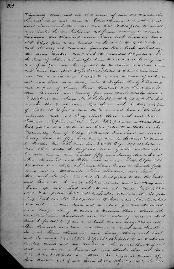
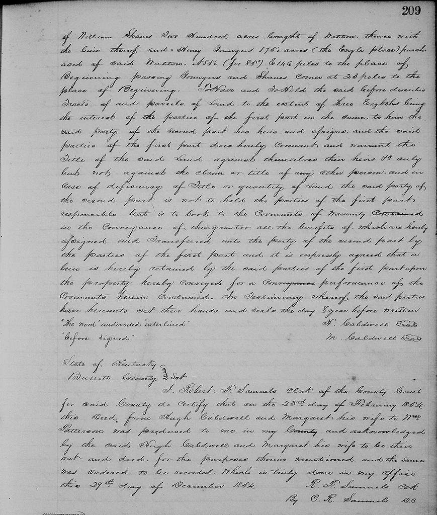
Also one other tract in the said County of Bullitt on the waters of Crooked Creek containing by survey 860 acres more or less and bounded as follows. Beginning at two beech trees, corner to a tract of 175.5 acres sold by M. Walton to Henry Younger in Purcell's line, thence with Purcell's line S 11.5° E (for 10°) 246 poles to a red oak marked as a side line, a gum marked as a center line tree and two beeches each marked C & H at the foot of a steep cliff near a run, the original corner trees (two beeches) not found, a corner of a 300 acre tract sold by said Walton to Jonathan Simmons, thence S 87°49' W (for West) 219 poles to two beech trees in a bottom near the foot of a hill and a corner to the said 300 acres and one hundred sold by said Walton to Robert Simmons, thence S 61.5° W (for 61) 34 poles to two beeches in the line of Colley McDaniel's 300 acre survey and corner to the said 300 and 100 acre surveys, then with McDaniel's line S 25° E 14 poles to a stake, N 33.5° E one half pole from a mulberry, supposed to be where two beeches originally stood and the southeast corner of said McDaniel's 300 acres and corner to Robert Simmons' 100 acres, thence with Simmons' line S 65° W 203 poles to an elm and beech, the two hickories not found, a corner to said Simmons' 100 acres, thence with Simmons' line S 25° E 572 poles to two beeches on the north bank of Crooked Creek, the original corner not found (an elm, beech and hickory) then down Crooked Creek with its meanders 196 poles to where the line of John B. Cundiff's land crosses and is the original line of a 700 acre survey sold by M. Walton to N. Harris, thence with said line N 51.5° W (for 52) 135 poles to a beech and ash trees corner to the said Cundiff's land and a corner of a 103 acre survey sold to Wilford Lee by G. Grundy and a part of Harris's 700 acre tract and a 425 acre tract sld by Harris to Wilford Lee, thence N 45° E (for 45.5) 31 poles to 3 beeches on the bank of Mud Run, thence with the original line of N 44.5° W 130 poles to a stake in said line in the Shepherdsville and Lee's Ferry Road, thence with said road towards Shepherdsville N 47.5° E 16.5 poles to a stake, N 54.5° E 64 poles to a stake, N 45.5° E 64.5 poles to a stake in the westwardly line of Colley McDaniel's 300 acre survey and the fifty acre survey sold by the said McDaniel to Smith, then with said line S 21°36' (for 25) 132 poles to two white oaks the original corner of said McDaniel's 300 acre survey and Smith's fifty acre survey, then with said 300 and 50 acre surveys N 64° E (for 65°) 46 poles to a white oak and elm corner to Smith's fifty acres and in McDaniels' 300 acre survey, then with Smith's line N21°36' E 141 poles to two red oaks and gum on the said Shepherdsville and Lee's Ferry road, thence up said road with its general course N 18.5° E 48 poles, N 42° W 10.5 poles, N 23° W 52 poles, N 22° E 50 poles, N 40° E 14 poles, N 47° E 16 poles, N 31° E 41 poles, N 57° E 42 poles, N 52.5° E 34.5 poles, to a stake in said road and in a line of a 200 acre survey sold by M. Walton to William Shain, thence with said line and hundred acre line sold by Walton to Hart S 23.5° E (for 25) 180 poles to a beech tree in Colley McDaniel's 300 acres line and corner to Hart and Jonathan Simmons' 300 acre survey, thence with Hart and Simmons' line N 85.5° E (for 85) 142 poles to a stake in Crooked Creek and two beeches on the north bank of said creek and corner to Simmons and Hart, then with their line N 20° W 118 poles to a stone, the original corner of three beeches not found, thence N 85.5° E (for 80) with the line of William Shain's 200 acres bought of Walton, thence with the line thereof and Henry Younger's 175.5 acres (the Engle place) purchased of said Walton N 85.5° (for 85°) E 146 poles to the place of beginning, passing Younger's and Shain's corner at 23 poles to the place of beginning.
To have and to hold the said before described tracts of and parcels of land to the extent of three eighths being the interest of the parties of the first part in the same, to him the said party of the second part, his heirs and assigns, and the said parties of the first part does hereby covenant and warrant the title of the said land against themselves their heirs &c only, but not against the claim or title of any other person, and in case of deficiency of title or quantity of land the said party of the second part is not to hold the parties of the first part responsible, but is to look to the covenants of warranty contained in the conveyance of their grantor, all the benefits of which are hereby assigned and transferred unto the party of the second part by the parties of the first part, and it is expressly agreed that a lien is hereby retained by the said parties of the first part upon the property hereby conveyed for a performance of the covenants herein contained. In testimony whereof the said parties have hereunto set their hands and seals the day and year before written. (signed) H. Caldwell, M. Caldwell
The Bullitt County History Museum, a service of the Bullitt County Genealogical Society, is located in the county courthouse at 300 South Buckman Street (Highway 61) in Shepherdsville, Kentucky. The museum, along with its research room, is open 10 a.m. to 4 p.m. Monday through Friday. Saturday appointments are available by calling 502-921-0161 during our regular weekday hours. Admission is free. The museum, as part of the Bullitt County Genealogical Society, is a 501(c)3 tax exempt organization and is classified as a 509(a)2 public charity. Contributions and bequests are deductible under section 2055, 2106, or 2522 of the Internal Revenue Code. Page last modified: 12 Apr 2026 . Page URL: bullittcountyhistory.org/bchistory/caldwell-patterson.html