
On 27 Aug 1800, Brooks and Moore exchanged plots of land in southern Jefferson County in two deeds, transcribed below. While these lands were primarily in Jefferson County, Brooks' activities at and around Mann's Lick relate to his role in Bullitt County history.
James Francis Moore to Joseph Brooks
1,682 Acres - Land Exchange
Jefferson County Deed Book 5, Pages 299-301
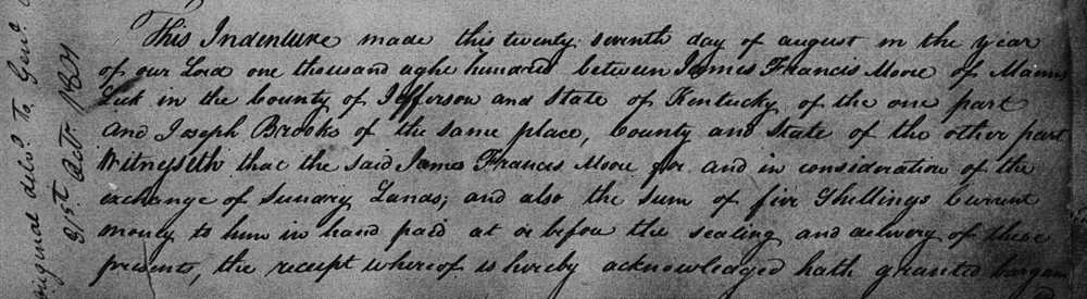
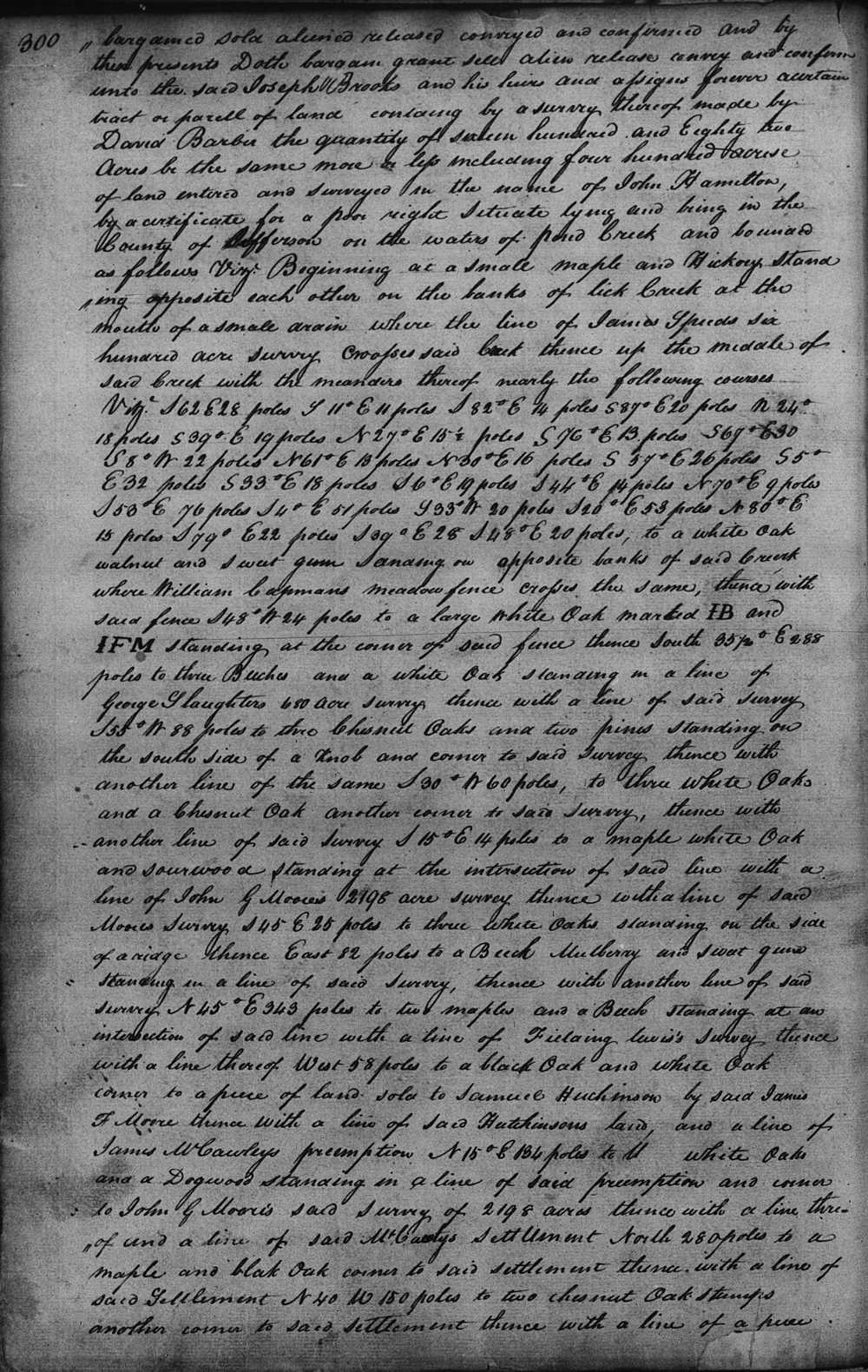
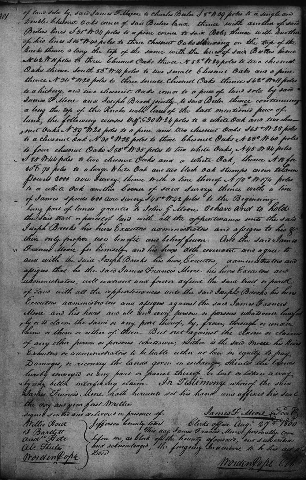
This indenture made this twenty seventh day of August in the year of our Lord one thousand eight hundred between James Francis Moore of Mann's Lick in the county of Jefferson and State of Kentucky of the one part and Joseph Brooks of the same place, county, and state of the other part. Witnesseth that the said James Francis Moore for and in consideration of the exchange of sundry lands, and also the sum of five shillings current money to him in hand paid at or before the sealing and delivery of these presents, the receipt whereof is hereby acknowledged, hath granted, bargained, sold, aliened, released, conveyed and confirmed and by these presents doth bargain, grant, sell, alien, release, convey and confirm unto the said Joseph Brooks and his heirs and assigns forever a certain tract or parcel of land containing by a survey thereof made by David Barbie the quantity of sixteen hundred and eighty two acres be the same more or less including four hundred acres of land entered and surveyed in the name of John Hamilton by a certificate for a poor right situate lying and being in the County of Jefferson on the waters of Pond Creek and bounded as follows viz. Beginning at a small maple and hickory standing opposite each other on the banks of Lick Creek at the mouth of a small drain where the line of James Speed's six hundred acre survey crosses said creek, thence up the middle of said creek with the meanders thereof nearly the following courses, viz. S 62° E 28 poles, S 11° E 11 poles, S 82° E 14 poles, S 87° E 20 poles, N 24° E 18 poles, S 39° E 19 poles, N 27° E 15 1/2 poles, S 76° E 13 poles, S 69° E 30 poles, S 8° W 22 poles, N 61° E 13 poles, N 30° E 16 poles, S 59° E 26 poles, S 5° E 32 poles, S 33° E 18 poles, S 6° E 19 poles, S 44° E 14 poles, N 70° E 9 poles, S 53° E 76 poles, S 4° E 51 poles, S 33° W 20 poles, S 20° E 53 poles, N 80° E 15 poles, S 79° E 22 poles, S 30° E 28 poles, S 48° E 20 poles, to a white oak, walnut and sweet gum standing on opposite banks of said creek where William Capman's meadow fence crosses the same, thence with said fence S 48° W 24 poles to a large white oak marked I.B. and I.F.M. standing at the corner of said fence, thence South 35 1/2 E 288 poles to three beeches and a white oak standing in a line of George Slaughter's 680 acre survey, thence with a line of said survey S 55° W 88 poles to three chestnut oaks and two pines standing on the south side of a knob and corner to said survey, thence with another line of the same S 30° W 60 poles to three white oaks and a chestnut oak another corner to said survey, thence with another line of said survey S 15° E 14 poles to a maple, white oak and sourwood standing at the intersection of said line with a line of John G. Moore's 2198 acre survey, thence with a line of said Moore's survey S 45° E 25 poles to three white oaks standing on the side of a ridge, thence East 82 poles to a beech, mulberry and sweet gum standing in a line of said survey, thence with another line of said survey N 45° E 343 poles to two maples and a beech standing at an intersection of said line with a line of Fielding Lewis' survey, thence with a line thereof West 58 poles to a black oak and white oak corner to a piece of land sold to Samuel Huchinson by said James F. Moore, thence with a line of said Hutchinson's land and a line of James McCawley's preemption N 15° E 134 poles to .. white oaks and a dogwood standing in a line of said preemption and corner to John G. Moore's said survey of 2198 acres, thence with a line of said settlement N 40° W 150 poles to two chestnut oak stumps another corner to said settlement, thence with a line of a piece of land sold by said James F. Moore to Charles Beeler S 8° W 39 poles to a single and double chestnut oaks corner of said Beeler's land, thence with another of said Beeler's lines S 31° W 34 poles to a pine corner to said Beeler, thence with another of his lines S 16° W 40 poles to three chestnut oaks standing on the top of the knobs, thence along the top of the same with the lines of said Beeler, thence N 62° W 11 poles to three chestnut oaks, thence N 52° W 24 poles to two chestnut oaks, thence South 83° W 14 poles to two small chestnut oaks and a pine, thence N 36° W 20 poles to three small chestnut oaks, thence S 62° W 11 poles to a kickory and two chestnut oaks corner to a piece of land sold by said James F. Moore and Joseph Brooks jointly to said Beeler, thence continuing along the top of the knobs with lines of the last mentioned piece of land the following courses viz. S 30° W 24 poles to a white oak and two chestnut oaks, N 59° W 20 poles to a pine and two chestnut oaks, S 65° W 28 poles to a chestnut oak, N 30° W 38 poles to three chestnut oaks, N 83° W 60 poles to four chestnut oaks S 65° W 35 poles to two white oaks, N 45° W 34 poles, S 85° W 44 poles to two chestnut oaks and a white oak, thence N 18° for 20° E 70 poles to a large white oak and two black oak stumps corner to Leven Powell's 2000 acre survey, thence with a line thereof N 70° W 174 poles to a white oak another corner of said survey, thence with a line of James Speed's 600 acre survey S 45° W 42 poles to the beginning, being part of lands granted to John G. Moore. To have and to hold the said tract or parcel of land with all the appurtenances unto the said Joseph Brooks, his heirs, executors, administrators and assigns to his & their only proper use, benefit and behoof forever. And the said James Francis Moore for himself and his heirs doth covenant and agree to and with the said Joseph Brooks, his heirs, executors, administrators and assigns that he the said James Francis Moore, his heirs, executors and administrators will warrant and forever defend the said tract or parcel of land with all the appurtenances unto the said Joseph Brooks, his heirs, executors, administrators and assigns against the said James Francis Moore and his heirs and all and every person or persons whatsoever lawfully or to claim the same or any part thereof by, from, through or under him or them or either of them. But not against the claim or claims of any other person or persons whatsoever; neither is the said Moore, his heirs, executors or administrators to be liable either at law in equity to pay damages or recovery the lands given in exchange should the lands hereby conveyed or any part or parcel thereof be lost or taken away by any better interfering claim. In testimony whereof the said James Francis Moore hath hereunto set his hand and affixed his seal the day and year first written. (signed) James F. Moore.
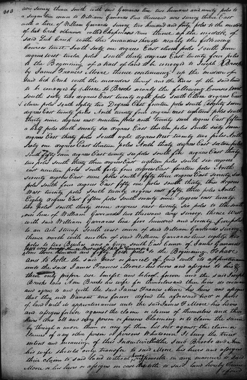
Joseph Brooks to James Francis Moore
1973.25 Acres - Land Exchange
Jefferson County Deed Book 5, Pages 302-304
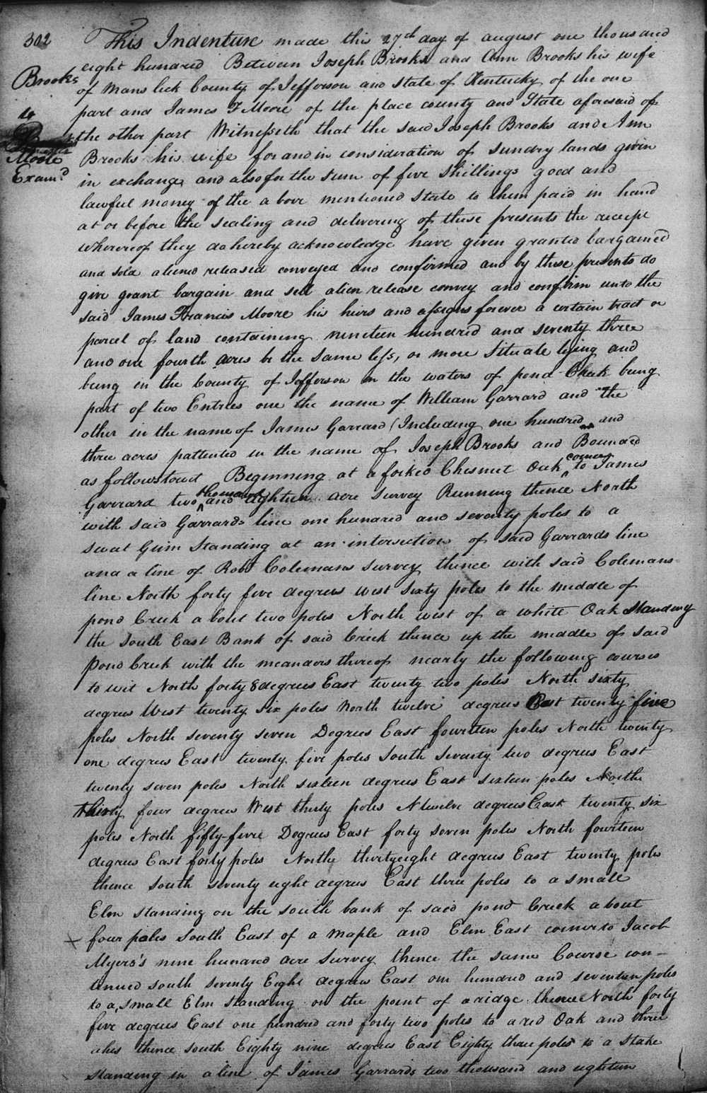
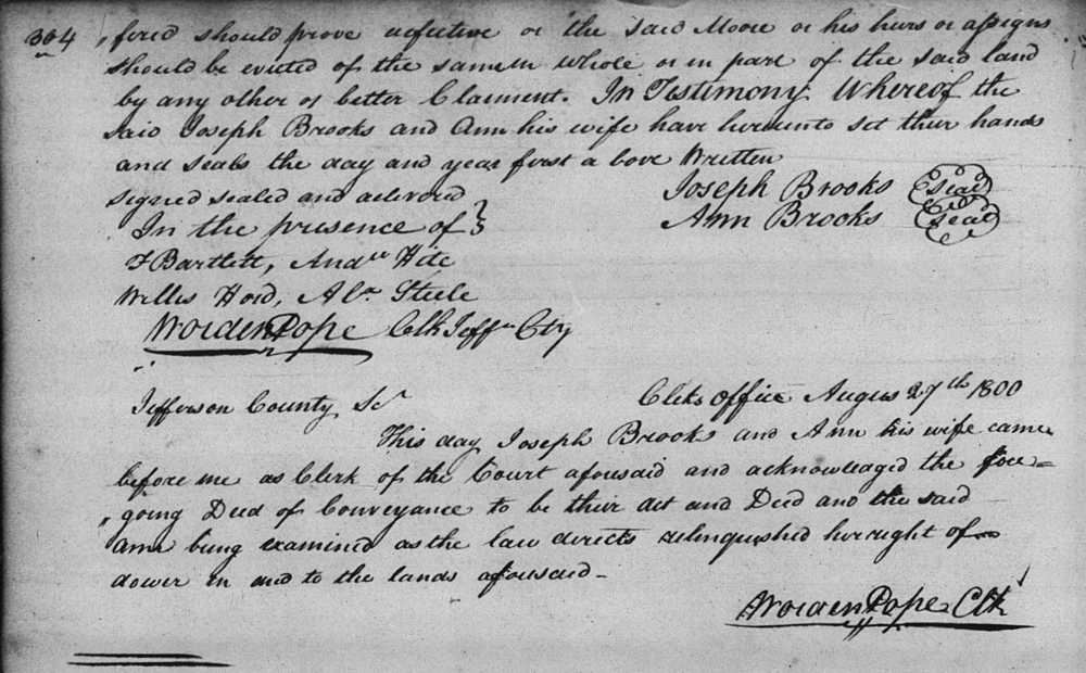
This indenture made this twenty seventh day of August in the year of our Lord one thousand eight hundred between Joseph Brooks and Ann Brooks his wife of Mann's Lick, county of Jefferson and State of Kentucky of the one part and James F. Moore of the place, county, and state of the other part. Witnesseth that the said Joseph Brooks and Ann Brooks his wife for and in consideration of sundry lands given in exchange, and also for the sum of five shillings good and lawful money of the above mentioned to them paid in hand at or before the sealing and delivery of these presents, the receipt whereof they do hereby acknowledge, have given, granted, bargained and sold, aliened, released, conveyed and confirmed and by these presents do give, grant, bargain and sell, alien, release, convey and confirm unto the said James Francis Moore, his heirs and assigns forever, a certain tract or parcel of land containing nineteen hundred and seventy three and one fourth acres, be the same less or more, situate, lying and being in the county of Jefferson on the waters of Pond Creek, being part of two entries, one the name of William Garrard and the other in the name of James Garrard (including one hundred and three acres patented in the name of Joseph Brooks) and bounded as follows to wit. Beginning at a forked chestnut oak corner to James Garrard's 2018 acre survey, running thence North with said Garrard's line 170 poles to a sweet gum standing at an intersection of said Garrard's line and a line of Robert Coleman's survey, thence with said Coleman's line North 45° West 60 poles to the middle of Pond Creek about two poles northwest of a white oak standing the southeast bank of said creek, thence up the middle of said Pond Creek with the meanders thereof nearly the following courses to wit. N 48° E 22 poles, N 60° W 26 poles, N 12° E 25 poles, N 77° E 14 poles, N 21° E 25 poles, S 72° E 27 poles, N 16° E 16 poles, N 34° W 30 poles, N 12° E 26 poles, N 55° E 47 poles, N 14° E 40 poles, N 38° E 20 poles, thence South 78° East 3 poles to a small elm standing on the south bank of said Pond Creek about four poles southeast of a maple and elm, east corner to Jacob Myers' 900 acre survey, thence the same course continued South 78° East 117 poles to a small elm standing on the point of a ridge, thence North 45° East 142 poles to a red oak and three ashes, thence South 89° East 83 poles to a stake standing in a line of James Garrard's 2018 acre survey, thence south with said Garrard's line 290 poles to a sugar tree corner to William Garrard's 2000 acre survey, thence East with a line of William Garrard's survey 240 poles to the middle of Lick Creek, otherwise called Chapman's Run, thence up the middle of said Lick Creek with the meanders thereof nearly the following courses to wit: S 61° E 11 poles, S 7° W 12 poles, S 30° E 24 poles to the beginning of a tract of land to be conveyed to Joseph Brooks by James Francis Moore, thence continuing up the middle of said Lick Creek with the meanders thereof and the lines of the said land to be conveyed by Moore to Brooks nearly the following courses to wit: S 62° E 28 poles, S 11° E 11 poles, S 82° E 14 poles, S 87° E 20 poles, N 24° E 18 poles, S 39° E 19 poles, N 27° E 15 1/2 poles, S 76° E 13 poles, S 67° E 30 poles, S 8° W 22 poles, N 61° E 13 poles, N 30° E 16 poles, S 59° E 26 poles, S 5° E 32 poles, S 33° E 18 poles, S 6° E 19 poles, S 44° E 14 poles, N 70° E 9 poles, S 53° E 76 poles, S 4° E 51 poles, S 33° W 20 poles, S 20° E 53 poles, N 80° E 15 poles, S 79° E 22 poles, S 39° E 26 poles to the southern line of William Garrard's 2000 acre survey, thence West with said William Garrard's line 575 poles to an ash stump southwest corner of said William Garrard's survey, thence north with another of said William Garrard's lines 82 poles to two beeches and a gum southeast corner of James Garrard's 2018 acre survey, thence west with said James Garrard's line 354 poles to the beginning. To have and to hold the said tract or parcel of land with its appurtenances unto the said James Francis Moore, his heirs and assigns to his & their only proper use, benefit and behoof forever, and the said Joseph Brooks and Ann Brooks his wife for themselves and their heirs do covenant and agree to and with the said James Francis Moore, his heirs and assigns, that they will warrant and forever defend the aforesaid tract or parcel of land with its appurtenances unto the said James F. Moore, his heirs and assigns, forever against the claim or claims of themselves and their heirs, and all and every person or persons claiming or to claim the same by, through or under them or any of them, but not against the claim or claims of any other person or persons whatsoever; it being the true intent and meaning of this indenture that the said Brooks and Ann his wife should only transfer to said Moore, his heirs and assigns, their claim to said land without being responsible in any manner to said Moore or his heirs or assigns in case the title to said land hereby transfered should prove defective or the said Moore or his heirs or assigns should be evicted of the same in whole or in part of the said land by any other or better claimant. In testimony whereof the said Joseph Brooks and Ann his wife have hereunto set their hands and seals the day and year first above written. (signed) Joseph Brooks, Ann Brooks.
Images of these deeds are shown below.
If you, the reader, have an interest in any particular part of our county history, and wish to contribute to this effort, use the form on our Contact Us page to send us your comments about this, or any Bullitt County History page. We welcome your comments and suggestions. If you feel that we have misspoken at any point, please feel free to point this out to us.
The Bullitt County History Museum, a service of the Bullitt County Genealogical Society, is located in the county courthouse at 300 South Buckman Street (Highway 61) in Shepherdsville, Kentucky. The museum, along with its research room, is open 10 a.m. to 4 p.m. Monday through Friday. Saturday appointments are available by calling 502-921-0161 during our regular weekday hours. Admission is free. The museum, as part of the Bullitt County Genealogical Society, is a 501(c)3 tax exempt organization and is classified as a 509(a)2 public charity. Contributions and bequests are deductible under section 2055, 2106, or 2522 of the Internal Revenue Code. Page last modified: 12 Apr 2026 . Page URL: bullittcountyhistory.org/bchistory/brooks-moore-exchange.html