
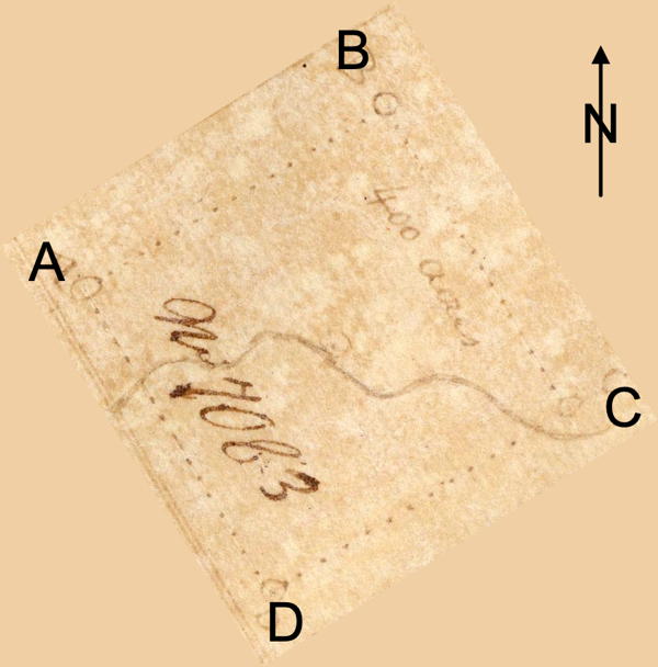
On 24 Aug 1790, John King surveyed 400 acres for John May and Mark Oyler as tenants in common along Long Lick Creek. This apparently adjoined King's own survey of 400 acres. May and Oyler obtained their deed to the land on 1 Aug 1796. We've rotated the tract drawing and enhanced it a bit so you can see it in its proper orientation.
Survey
Surveyed for John May and Mark Oyler as tenants in common 400 acres of land by virtue of a preemption warrant No. 1146 in Nelson County on the waters of Long Lick Creek, a branch of Salt River, and bonded as followeth, viz. Beginning at two beeches and a sugar tree, thence North 58° East 253 poles to two poplars and a beech standing near Wilsons, thence South 32° East 253 poles to two sugar trees and blue ash, thence South 58° West 253 poles to three beeches stand on the road leading from Kings to Long Lick, crossing Long Lick at 40 poles, thence North 32° West 253 poles to the beginning crossing Long Lick Creek at 184 poles. 24th August 1790. John E. King, surveyor. Weathers King & Richard Cunningham, chain carriers.

Deed
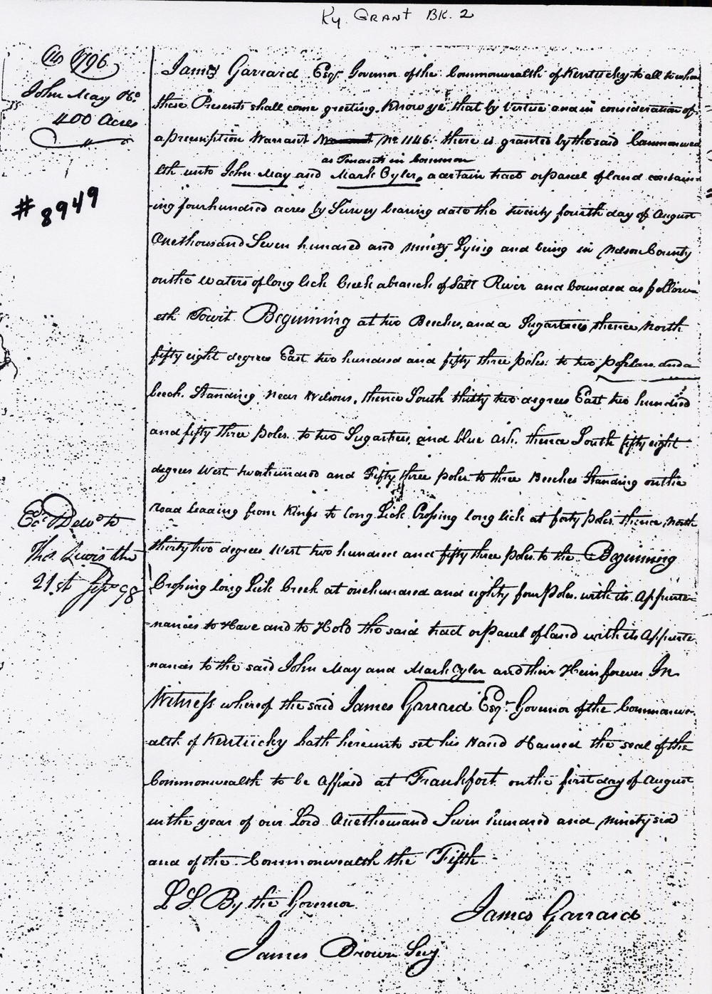
Kentucky Grant Book 2, pages 14
James Garrard Esquire, Governor of the Commonwealth of Kentucky, to all whom these presents shall come, greeting. Know ye that by virtue and in consideration of a preemption warrant No. 1146, there is granted by the said Commonwealth unto Daniel Ketcham and Walter Brashear, said Brashear assignee of said Ketcham and said Ketcham heir at law to John May and Mark Oyler, as tenants in common, a certain tract or parcel of land containing 400 acres by survey bearing date the 24th day of August 1790, lying and being in Nelson County on the waters of Long Lick Creek, a branch of Salt River and bounded as followeth, to wit. Beginning at two beeches and a sugar tree, thence North 58° East 253 poles to two poplars and a beech standing near Wilsons, thence South 32° East 253 poles to two sugar trees and blue ash, thence South 58° West 253 poles to three beeches stand on the road leading from Kings to Long Lick, crossing Long Lick at 40 poles, thence North 32° West 253 poles to the beginning crossing Long Lick Creek at 184 poles with its appurtenances to have and to hold the said tract or parcel of land with its appurtenances to the said John May and Mark Oyler and their heirs forever. In witness whereof the said James Garrard Esquire, Governor of the Commonwealth of Kentucky, hath hereunto set his hand and caused the seal of the said Commonwealth to be affixed at Frankfort on the 1st day of August in the year of our Lord 1796, and of the Commonwealth the 5th. (signed) James Garrard.
Warrants
If you, the reader, have an interest in any particular part of our county history, and wish to contribute to this effort, use the form on our Contact Us page to send us your comments about this, or any Bullitt County History page. We welcome your comments and suggestions. If you feel that we have misspoken at any point, please feel free to point this out to us.
The Bullitt County History Museum, a service of the Bullitt County Genealogical Society, is located in the county courthouse at 300 South Buckman Street (Highway 61) in Shepherdsville, Kentucky. The museum, along with its research room, is open 10 a.m. to 4 p.m. Monday through Friday. Saturday appointments are available by calling 502-921-0161 during our regular weekday hours. Admission is free. The museum, as part of the Bullitt County Genealogical Society, is a 501(c)3 tax exempt organization and is classified as a 509(a)2 public charity. Contributions and bequests are deductible under section 2055, 2106, or 2522 of the Internal Revenue Code. Page last modified: 21 Apr 2026 . Page URL: bullittcountyhistory.org/bchistory/8949-may-oyler.html