
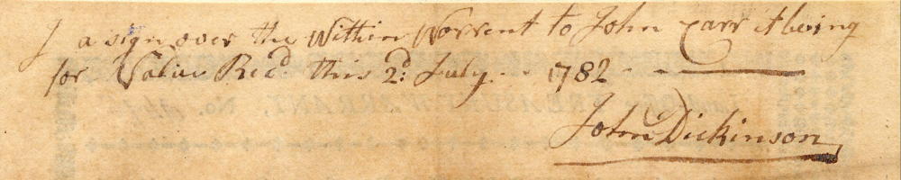
On 8 Aug 1786, George Calhoun surveyed 587 3/4 acres on the waters of Crooked Creek for John Carr based on a treasury warrant originally issued in the name of John Dickerson who endorsed it over to Carr on 2 Jul 1782. Carr endorsed the survey over to Abner Luse on the day it was completed. Luse then obtained his deed to the land on 25 Aug 1788.
Survey
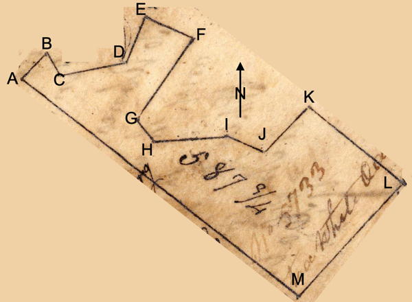
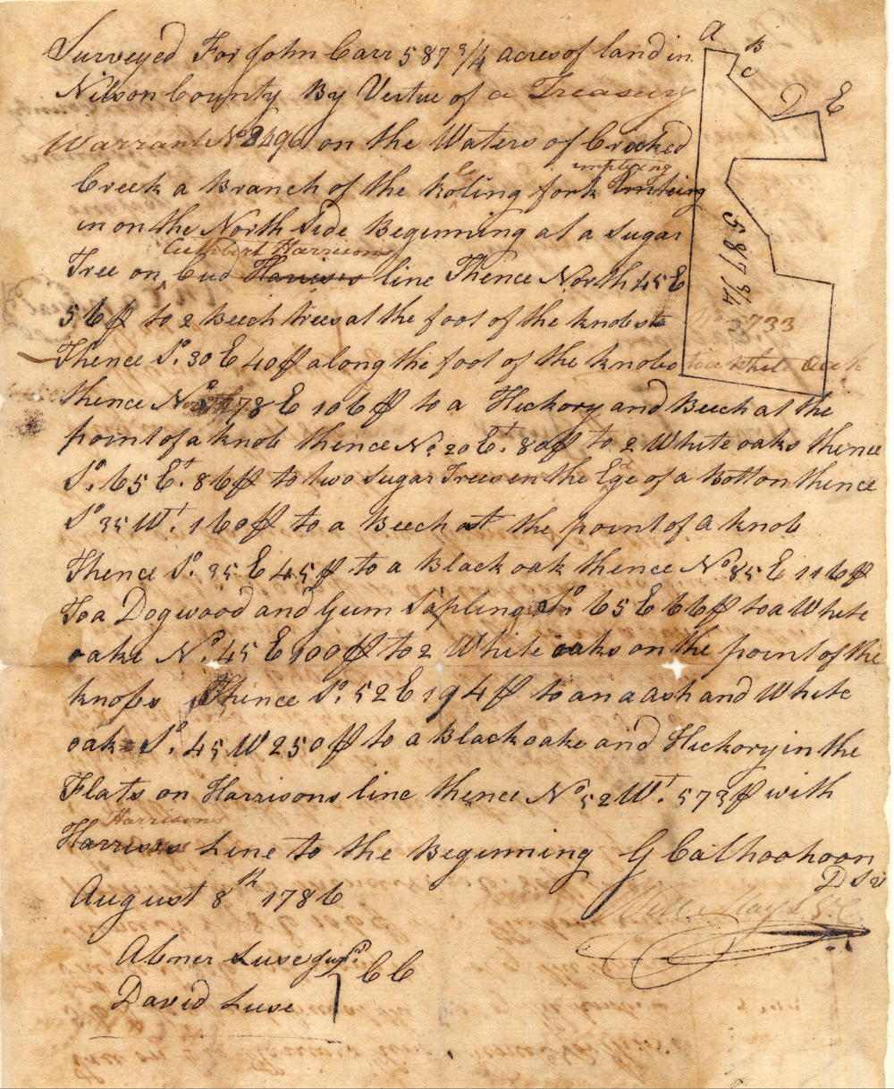
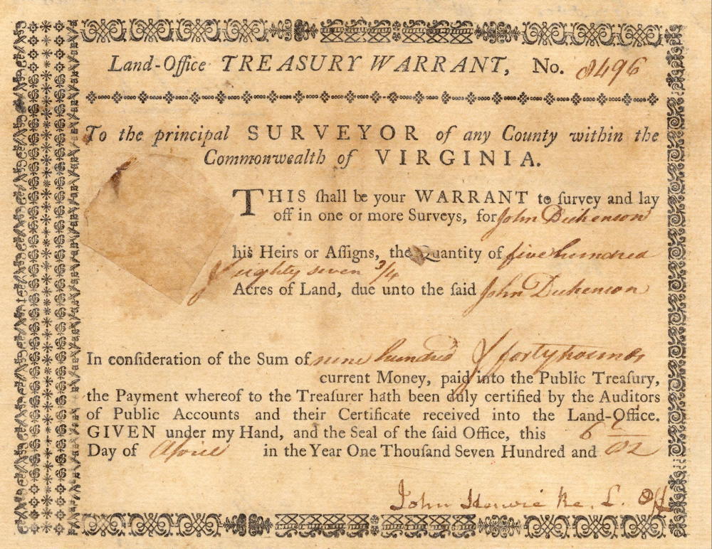
Surveyed for John Carr 587 3/4 acres of land in Nelson County by virtue of a treasury warrant No. 8496 on the waters of Crooked Creek a branch of the Rolling Fork emptying in on the north side, beginning at [A] a sugar tree on Cuthbert Harrison's line, thence North 55° East 56 poles to [B] two beech trees at the top of the knobs, thence South 30° East 40 poles along the foot of the knobs, to [C] a white oak, thence North 78° East 106 poles to [D] a hickory and beech at the point of a knob, thence North 20° East 80 poles to [E] 2 white oaks, thence South 65° East 36 poles to [F] two sugar trees in the edge of a bottom, thence South 35° West 160 poles to [G] a beech at the point of a knob, thence South 35° East 45 poles to [H] a black oak, thence North 85° East 116 poles to [I] a dogwood and gum sapling, South 65° East 66 poles to [J] a white oak, North 45° East 100 poles to [K] 2 white oaks on the point of the knobs, thence South 52° East 194 poles to [L] an ash and white oak, South 45° West 250 poles to [M] a black oak and hickory in the flats on Harrison's line, thence North 52° West 573 poles with Harrison's line to the beginning. G. Calhoon, surveyor. Abner Luse Jr & David Luse, chain carriers.
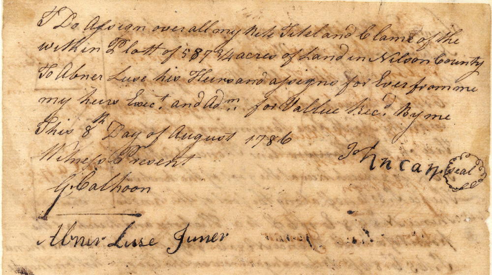
I do assign over all my right, title and claim of the within plat of 587 3/4 acres of land in Nelson County to Abner Luse, his heirs and assigns forever from me, my heirs, executors and administrators for value received by me this 8t day of August 1786. (signed) John Carr. Witnesses present: G. Calhoon, Abner Luse Jr.
Deed
Virginia Grant Book 15, Pages 65-66
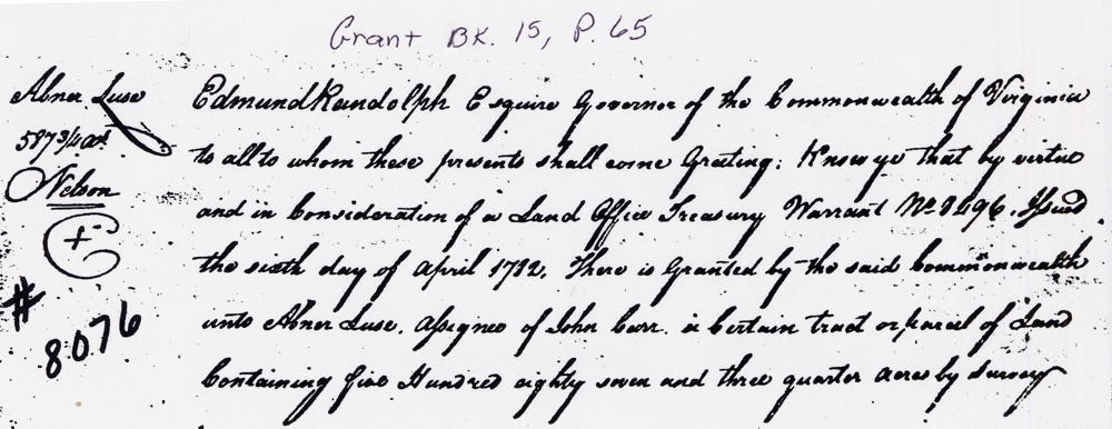
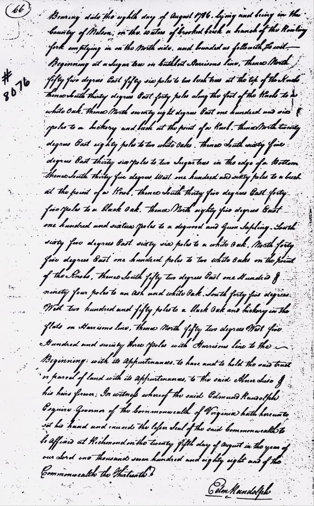
Edmund Randolph Esquire, governor of the Commonwealth of Virginia, to all to whom these presents shall come, greeting. Know ye that by virtue and in consideration in part of a land office treasury warrant No. 8496 issued the 6th day of April 1782, there is granted by the said Commonwealth unto Abner Luse, assignee of John Carr, a certain tract or parcel of land containing 587 3/4 acres by survey bearing date the eighth day of August 1786, lying and being in the County of Nelson on the waters of Crooked Creek, a branch of the Rolling Fork emptying in on the north side and bounded as followeth, to wit. Beginning at a sugar tree on Cuthbert Harrison's line, thence North 55° East 56 poles to two beech trees at the top of the knobs, thence South 30° East 40 poles along the foot of the knobs, to a white oak, thence North 78° East 106 poles to a hickory and beech at the point of a knob, thence North 20° East 80 poles to 2 white oaks, thence South 65° East 36 poles to two sugar trees in the edge of a bottom, thence South 35° West 160 poles to a beech at the point of a knob, thence South 35° East 45 poles to a black oak, thence North 85° East 116 poles to a dogwood and gum sapling, South 65° East 66 poles to a white oak, North 45° East 100 poles to 2 white oaks on the point of the knobs, thence South 52° East 194 poles to an ash and white oak, South 45° West 250 poles to a black oak and hickory in the flats on Harrison's line, thence North 52° West 573 poles with Harrison's line to the beginning with its appurtenances to have and to hold the said tract or parcel of land with its appurtenances to the said Abner Luse and his heirs forever. In witness whereof the said Edmund Randolph Esquire, governor of the Commonwealth of Virginia, hath hereunto set his hand and caused the lesser seal of the Commonwealth to be affixed at Richmond on the 25th day of August in the year of our Lord 1788, and of the Commonwealth the 13th. (signed) Edm. Randolph
Warrant
If you, the reader, have an interest in any particular part of our county history, and wish to contribute to this effort, use the form on our Contact Us page to send us your comments about this, or any Bullitt County History page. We welcome your comments and suggestions. If you feel that we have misspoken at any point, please feel free to point this out to us.
The Bullitt County History Museum, a service of the Bullitt County Genealogical Society, is located in the county courthouse at 300 South Buckman Street (Highway 61) in Shepherdsville, Kentucky. The museum, along with its research room, is open 10 a.m. to 4 p.m. Monday through Friday. Saturday appointments are available by calling 502-921-0161 during our regular weekday hours. Admission is free. The museum, as part of the Bullitt County Genealogical Society, is a 501(c)3 tax exempt organization and is classified as a 509(a)2 public charity. Contributions and bequests are deductible under section 2055, 2106, or 2522 of the Internal Revenue Code. Page last modified: 21 Apr 2026 . Page URL: bullittcountyhistory.org/bchistory/8076-luse.html