
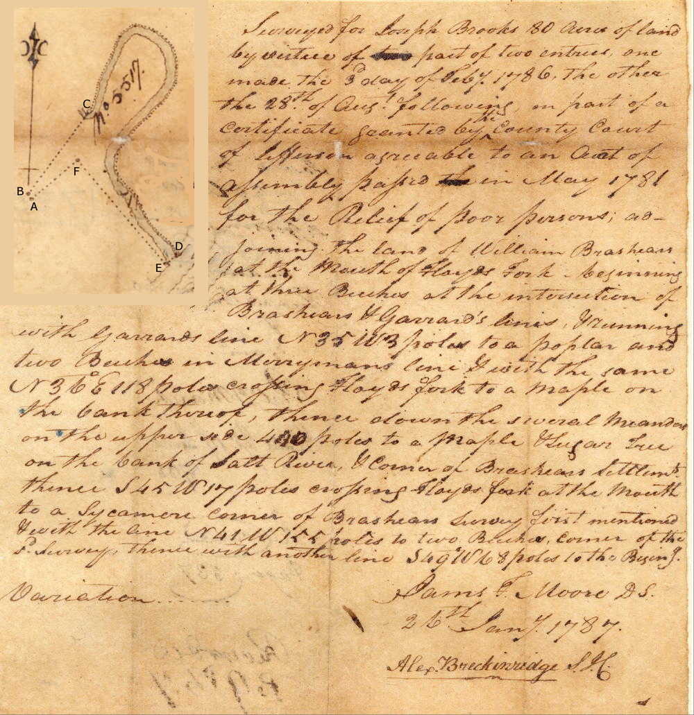
On 4 Dec 1781, the Jefferson County Court, pursuant to an act of the Virginia Assembly to provide land for poor residents, issued an order for the county surveyor to lay off 400 acres of unclaimed land for Jacob Williams. It appears that Williams signed that over to someone else, and eventually Joseph Brooks came into possession of it. He used part of it and part of another certificate when he hired James F. Moore to survey 80 acres for him that lay mostly within the first loop of Floyd's Fork above its mouth. Moore completed this survey on 26 Jan 1787, and Brooks obtained a deed to it on 19 Jun 1788. The drawing shown in the survey image below can be compared with a modern map to locate this tract.
Survey
Surveyed for Joseph Brooks 80 acres of land by virtue of part of two entries, one made the third day of February 1786, the other the 28th day of August following, on part of a certificate granted by the county court of Jefferson agreeable to an Act of Assembly passed in May 1781 for the relief of poor persons adjoining the land of William Brashear at the mouth of Floyd's Fork, beginning at [A] three beeches at the intersection of Brashears' and Garrard's lines and running with Garrard's line N 35° W 3 poles to [B] a poplar and two beeches in Merryman's line & with the same N 36° E 118 poles crossing Floyd's Fork to [C] a maple on the bank thereof, thence down the several meanders on the upper side 440 poles to [D] a maple & sugar tree on the bank of Salt River & corner of Brashear's Settlement, thence S 45° W 17 poles crossing Floyd's Fork at the mouth to [E] a sycamore corner of Brashear's survey first mentioned & with the line N 41° W 155 poles to [F] two beeches, corner of the said survey, thence with another line S 49° W 68 poles to the beginning. James F. Moore, surveyor. 26th Jan 1787.
Court Order
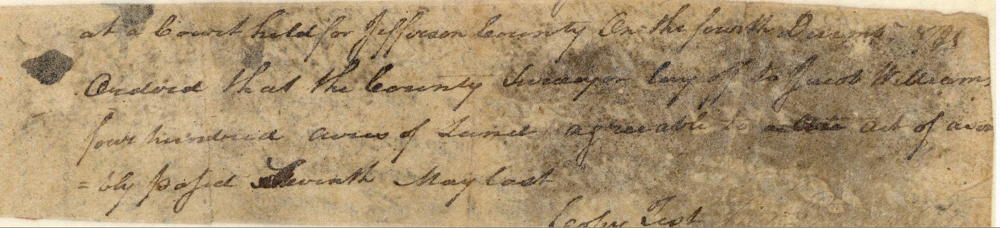
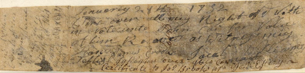
At a court held for Jefferson County on the fourth December 1781, ordered that the county surveyor lay off to Jacob Williams four hundred acres of land agreeable to the Act of Assembly issued seventh May last. ... I give over all my right of title in note unto John ?? for value of him received. As witness my hand James Crooke. Jacob Williams. ... I assign over this certificate to Joseph Brooks. John Essery
Deed
Virginia Grant Books 16, pages 27-28
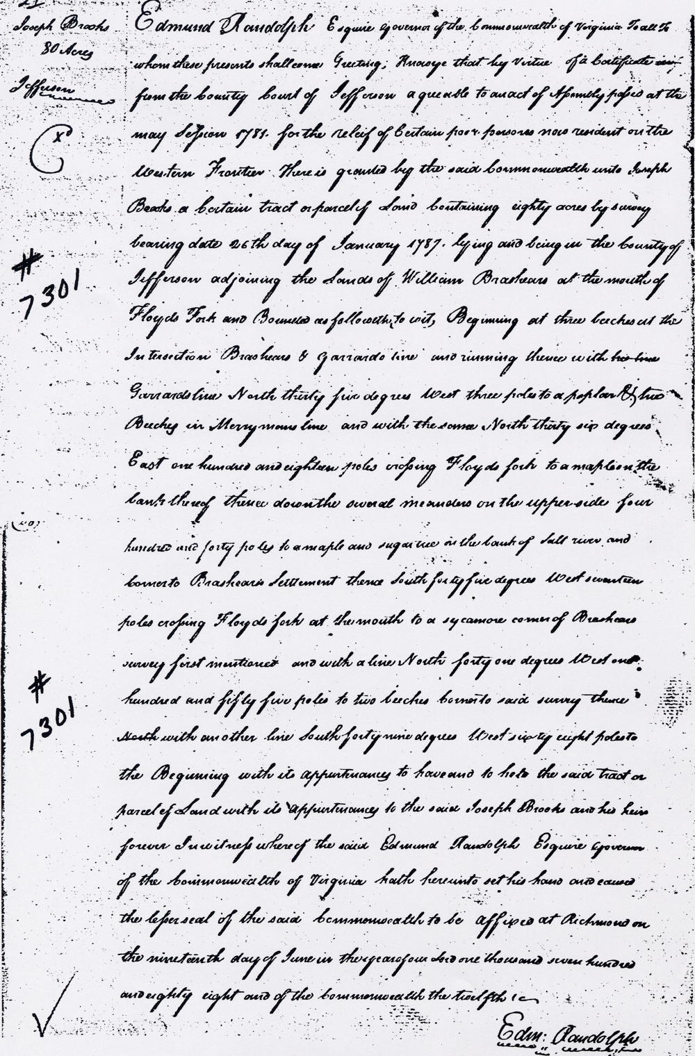
Edmund Randolph Esquire, governor of the Commonwealth of Virginia, to all to whom these presents shall come, greeting. Know ye that by virtue of a certificate from the county court of Jefferson agreeable to an act of assembly issued at the May session 1781 for the relief of poor persons now residing on the western frontier, there is granted by the said Commonwealth unto Joseph Brooks a certain tract or parcel of land containing eighty acres by survey bearing date 26th day of January 1787, lying and being in the county of Jefferson adjoining the lands of William Brashears at the mouth of Floyd's Fork and bounded as followeth, to wit. beginning at three beeches at the intersection Brashears' and Garrard's line and running with Garrard's line North 35° West 3 poles to a poplar and two beeches in Merryman's line & with the same North 36° East 118 poles crossing Floyd's Fork to a maple on the bank thereof, thence down the several meanders on the upper side 440 poles to a maple & sugar tree on the bank of Salt River & corner to Brashear's Settlement, thence South 45° West 17 poles crossing Floyd's Fork at the mouth to a sycamore corner of Brashear's survey first mentioned & with the line North 41° West 155 poles to two beeches, corner to said survey, thence with another line South 49° West 68 poles to the beginning with its appurtenances to have and to hold the said tract or parcel of land unto Joseph Brooks and his heirs forever. In witness whereof the said Edmund Randolph Esquire, governor of the Commonwealth of Virginia, hath hereunto set his hand and caused the lesser seal of the said Commonwealth to be affixed at Richmond on the 19th day of June in the year of our Lord 1788, and of the Commonwealth the 12th. (signed) Edmund Randolph
If you, the reader, have an interest in any particular part of our county history, and wish to contribute to this effort, use the form on our Contact Us page to send us your comments about this, or any Bullitt County History page. We welcome your comments and suggestions. If you feel that we have misspoken at any point, please feel free to point this out to us.
The Bullitt County History Museum, a service of the Bullitt County Genealogical Society, is located in the county courthouse at 300 South Buckman Street (Highway 61) in Shepherdsville, Kentucky. The museum, along with its research room, is open 10 a.m. to 4 p.m. Monday through Friday. Saturday appointments are available by calling 502-921-0161 during our regular weekday hours. Admission is free. The museum, as part of the Bullitt County Genealogical Society, is a 501(c)3 tax exempt organization and is classified as a 509(a)2 public charity. Contributions and bequests are deductible under section 2055, 2106, or 2522 of the Internal Revenue Code. Page last modified: 21 Apr 2026 . Page URL: bullittcountyhistory.org/bchistory/7301-brooks.html