
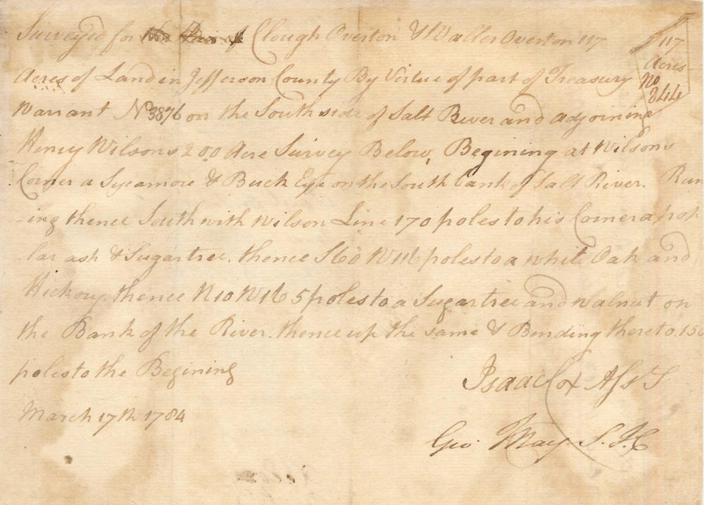
Isaac Cox surveyed this 117 acre tract for Waller & Clough Overton on the south side of Salt River, downstream from Henry Wilson's 200 acres on 17 Mar 1784, The deed was signed on 16 Jan 1786.
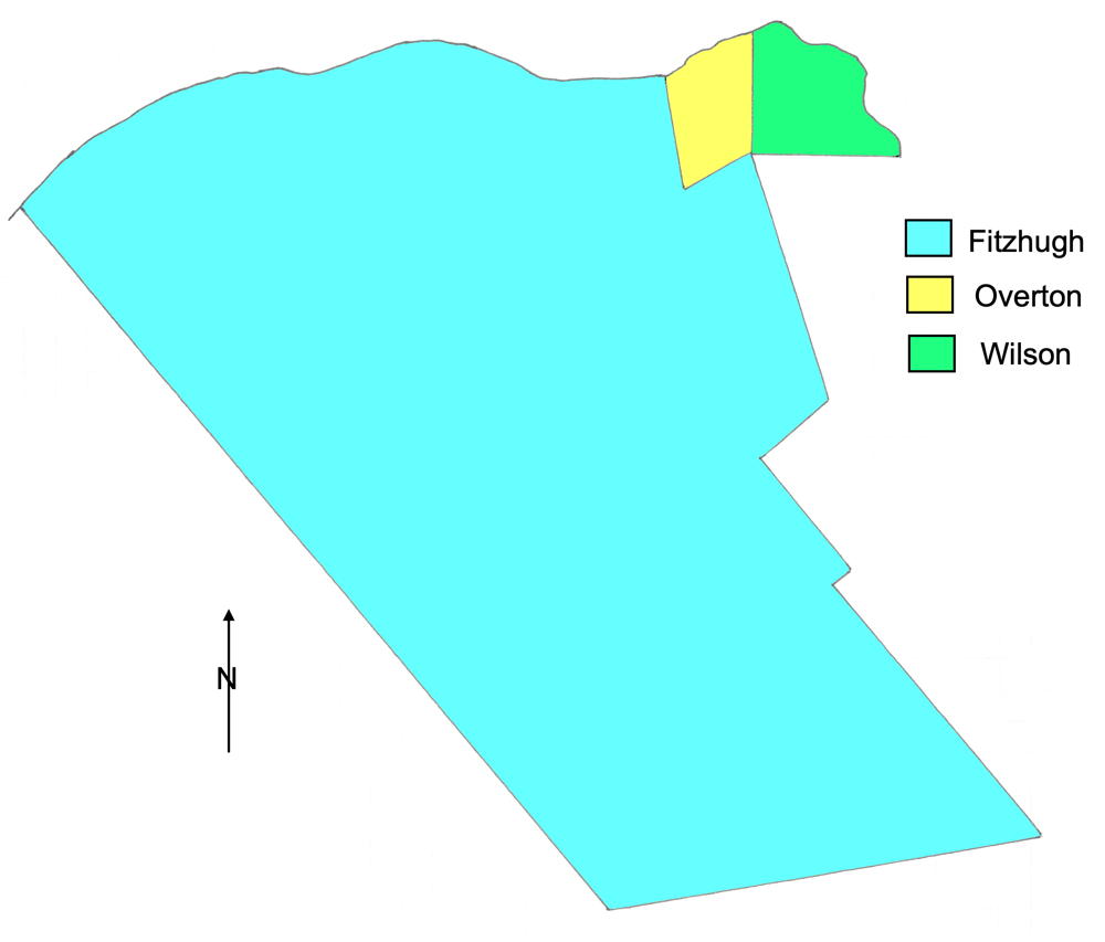
The drawing to the right shows the Overton tract in relation to the tract of Henry Wilson, and the large tract patented to William Fitzhugh. Salt River forms the northern border of these three tracts, and is roughly drawn in on this drawing.
Survey
Surveyed for Clough Overton & William Overton 117 acres of land in Jefferson County by virtue of part of treasury warrant No. 3876 on the south side of Salt River and adjoining Henry Wilson's 200 acre survey below. Beginning at Wilson's corner a sycamore & buckeye on the south bank of Salt River, running thence South with Wilson's line 170 poles to his corner poplar, ash & sugar tree, thence S 60 W 116 poles to a white oak and hickory, thence N 10 W 165 poles to a sugar tree and walnut on the bank of the river, thence up the same & binding thereon 150 poles to the beginning. March 17th 1784. Isaac Cox, surveyor.
Deed
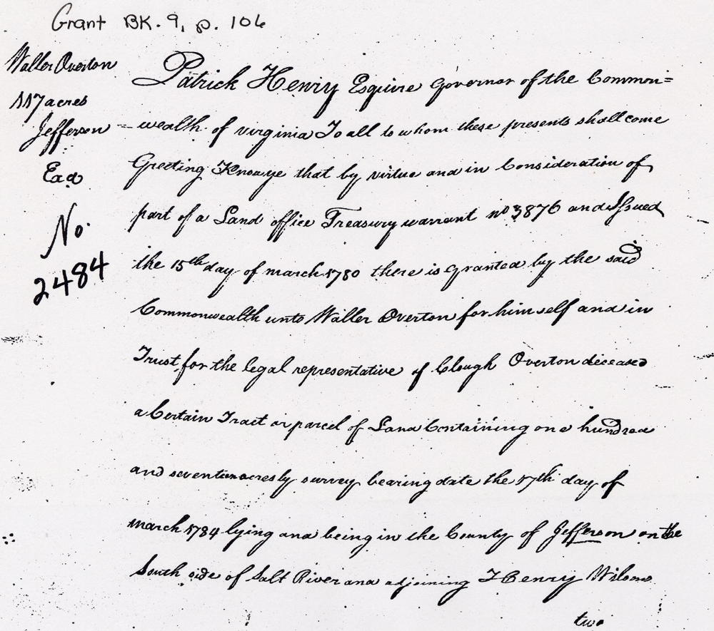
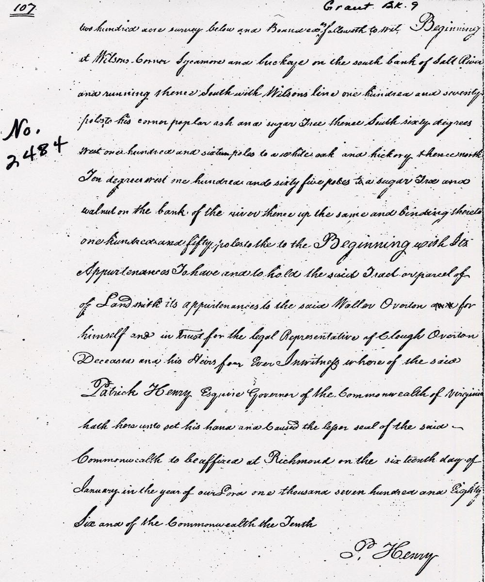
Virginia Grant Book 9, pages 106-7
Patrick Henry Esquire, Governor of the Commonwealth of Virginia, to all to whom these presents shall come, greeting. Know ye that by virtue of and in consideration of a land office treasury warrant number 3876 issue the 15th day of March 1780, there is granted by the said Commonwealth unto Waller Overton for himself and in trust for the legal representative of Clough Overton deceased a certain tract or parcel of land containing 117 acres by survey bearing date the 17th day of March 1784, lying and being in the county of Jefferson on the south side of Salt River and adjoining Henry Wilson's 200 acre below and bounded as followeth, to wit. Beginning at Wilson's corner sycamore & buckeye on the south bank of Salt River, running thence South with Wilson's line 170 poles to his corner poplar, ash & sugar tree, thence South 60° West 116 poles to a white oak and hickory, thence North 10° West 165 poles to a sugar tree and walnut on the bank of the river, thence up the same & binding thereon 150 poles to the beginning with its appurtenances to have and to hold the said tract or parcel of land with its appurtenances to the said Waller Overton for himself and in trust for the legal representative of Clough Overton deceased & his heirs forever. In witness whereof the said Patrick Henry Esquire, Governor of the Commonwealth of Virginia, hath hereunto set his hand and caused the lesser seal of the said Commonwealth to be affixed at Richmond on the 16th day of January in the year of our Lord one thousand seven hundred and eighty six & of the Commonwealth the tenth. (signed) Patrick Henry
If you, the reader, have an interest in any particular part of our county history, and wish to contribute to this effort, use the form on our Contact Us page to send us your comments about this, or any Bullitt County History page. We welcome your comments and suggestions. If you feel that we have misspoken at any point, please feel free to point this out to us.
The Bullitt County History Museum, a service of the Bullitt County Genealogical Society, is located in the county courthouse at 300 South Buckman Street (Highway 61) in Shepherdsville, Kentucky. The museum, along with its research room, is open 10 a.m. to 4 p.m. Monday through Friday. Saturday appointments are available by calling 502-921-0161 during our regular weekday hours. Admission is free. The museum, as part of the Bullitt County Genealogical Society, is a 501(c)3 tax exempt organization and is classified as a 509(a)2 public charity. Contributions and bequests are deductible under section 2055, 2106, or 2522 of the Internal Revenue Code. Page last modified: 21 Apr 2026 . Page URL: bullittcountyhistory.org/bchistory/2484-overton.html