The following article by Charles Hartley originally appeared in The Courier-Journal on 20 June 2012. It is archived here with additional information for your reading enjoyment. The General Assembly Act referred to herein may be viewed on another page.
In March 1890, the Kentucky General Assembly approved the formation of a corporation of eleven men under the name, "The Louisville Southeastern Railroad Company." The business of this company was to construct and operate a railway line from Louisville, through Jefferson and Bullitt Counties, to pass near the town of Mt. Washington, and on to Smithville near the Salt River.
At that time Bardstown Road was mainly a dirt and gravel road, making travel in the area inconvenient.
Railroad construction had been an important spur to economic growth since the Civil War, and trains from Louisville reached Shepherdsville and points south, followed by junctions at Bardstown Junction and Lebanon Junction. Daily passenger trains traveled through Shepherdsville to Bardstown and points east, but Mt. Washington saw none of this.
Each of these men had an interest in seeing a track laid southward along Bardstown Road. For most it was a financial interest because they owned land along the way. Before we discuss the outcome of this venture, let's identify the men involved. The map below shows the general locations of most of the farms.
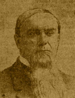
George W. Swearingen grew up in Bullitt County before moving to Louisville after the Civil War. He built the Mellwood distillery on Mellwood Avenue between Frankfort Avenue and Brownsboro Road, before becoming the president of the Kentucky Title Company. Turning next to the banking industry, he joined other business men of the city to establish the Union National Bank about 1889. He never lost his love for his childhood home county, and this may have been the reason he joined in this railroad venture.
George W. Scoggan and his brother Hiram were in the horse trading business when George bought the old Bray place in 1888, 210 acres bordered by what is now Bardstown Road, Goldsmith Lane and Hikes Lane. (A on the map.) He turned it into a horse farm that produced several Kentucky Derby contestants, and one winner - Lookout in 1893.
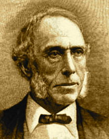
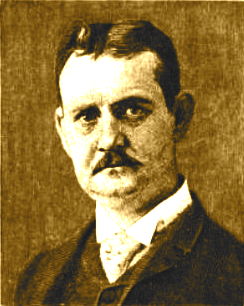
George J. Long was associated with his father, Dennis Long, in the foundry business. In 1887 he purchased the Bashford Manor farm from James Bennett Wilder, its founder. The farm was located within the present-day bounds of Watterson Expressway, Newburg Road, Bashford Manor Lane, and Bardstown Road, (B on the map) and lay west of the Scoggan farm. The proposed railroad might have passed between them, or just to the south at the junction of the Louisville Southern tracks.
The Dennis Long named in the charter was either George's brother, or their father. The brother, Dennis Matthew Long, died in 1891, and their father followed in 1893.
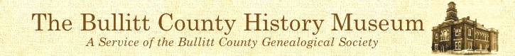
As a youngster, Judge William B. Hoke attended the Mt. Washington Academy. Later joining the legal profession, he became a county judge for Jefferson County in 1866, a position he maintained at the time of the railroad charter. His farm was located on the southwesterly side of Old Shepherdsville Road near the Louisville Southern railroad track, (C on the map) near where the proposed railroad would likely begin, giving him a vested interest in it.
James B. Camp was Hoke's son-in-law. Over the years he worked in a variety of occupations, from journalist to secretary for the Chief of Police to business manager of an amphitheatre auditorium, the job he held in 1890. It is likely that he was included both for his managerial skills, and because of his relation to Judge Hoke.
Dr. Thomas A. Hays grew up in the family home at Fairmount which then stood on the west side of what is today Old Bardstown Road, just north of Fairmount Road. (D on the map.) His family owned considerable land on both sides of Bardstown Road, giving them reason to join in the proposal.
The Thixton family owned land adjoining Bardstown Road south of Fairmount. According to an 1879 map, Thomas H. Thixton's home was along Thixton Lane close by where Tunnel Way connects with it today. (E on the map.) As the elder member of the family he joined this project in the family's interest.
The remaining three men lived in Bullitt County.
Francis Oliver Carrithers was a director of Peoples Bank of Mt. Washington in its 1890 incorporation. The Carrithers family owned farmland on both sides of Floyd's Fork, with Francis' land lying on both sides of the county line. (F on the map.) He was also a long-time Bullitt County magistrate.
John T. Lux, began his adult life as a teacher in the area, but seeking adventure he moved to New Mexico Territory where he opened the Lux Academy in Taos County. After a brief marriage, and a short stint in the Confederate army, he returned to Mt. Washington where he was a store clerk in 1870. He sold the family home site (G is general location on the map) in Mt. Washington in December 1890, possibly to raise money for this venture.
The last man, James Douglas Wright was a farmer in Bullitt County where he married Lillie N. Bridwell in 1883. The family's farm lay near where Stringer Lane meets Bardstown Road, (H on the map) just north of Smithville. Later he would move to Louisville where he became a real estate broker. His interest in real estate may have begun with this venture.
Despite their combined wealth and stature in these communities, these eleven men needed the financial support of many others, through the sale of stock, to make this railroad a reality. A decade earlier that might have been no problem, but by the beginning of the 1890's a combination of economic factors had slowed railroad investment. Then an economic depression began in January 1893 that would last the rest of the decade, putting an end to their plans.
It would be another quarter-century before significant improvements were made to Bardstown Road down to Mt. Washington; but the trains would never run this way. As you travel down the modern highway into Mt. Washington today, cast your mind's eye back in time and imagine the trains that might have been.
Copyright 2012 by Charles Hartley, Shepherdsville KY. All rights are reserved. No part of the content of this page may be included in any format in any place without the written permission of the copyright holder.
The Bullitt County History Museum, a service of the Bullitt County Genealogical Society, is located in the county courthouse at 300 South Buckman Street (Highway 61) in Shepherdsville, Kentucky. The museum, along with its research room, is open 10 a.m. to 4 p.m. Monday through Friday. Saturday appointments are available by calling 502-921-0161 during our regular weekday hours. Admission is free. The museum, as part of the Bullitt County Genealogical Society, is a 501(c)3 tax exempt organization and is classified as a 509(a)2 public charity. Contributions and bequests are deductible under section 2055, 2106, or 2522 of the Internal Revenue Code. Page last modified: 13 Jan 2024 . Page URL: bullittcountyhistory.org/memories/mwtrain.html