The following article by Charles Hartley was published on 18 October 2015. It is archived here for your reading enjoyment.
In 1796, John Adams was elected President of the United States, James Garrard was elected as Kentucky's second governor, and the Kentucky legislature met in Frankfort to conduct the Commonwealth's business. Creating new Kentucky counties was part of that business.
Kentucky County, Virginia had been created in 1777, and three years later it was divided into three separate counties: Fayette, Jefferson, and Lincoln. Then, in 1785, Nelson County was created out of Jefferson County. The dividing line was the Salt River.
The Commonwealth of Kentucky was admitted as a state in 1792 with nine counties. The next year, the first legislature, meeting in Lexington, passed an act that stated in part, "It is represented to the present general assembly, that it would be advantageous to many of the inhabitants of the counties of Nelson and Jefferson, if a town was established on the land of Adam Shepherd, lying on the north side of Salt river, at the lower end of the falls of said river, where the great road leading to Bullitt's lick crosses the same."
That act gave Nacy Brashears, Samuel Crow, Michael Troutman, Frederick Pennybaker, Benjamin Stansberry, Joseph Brooks and John Essery authority as trustees of this new town to be laid out on fifty acres. The first survey was completed by Benjamin Stansberry. It is likely that these folks, along with Adam Shepherd himself, already had in mind to make this town the seat of a new county.
By the time the Kentucky legislature met in 1796, the state had nineteen counties. That legislature was about to create six more including Bullitt County.
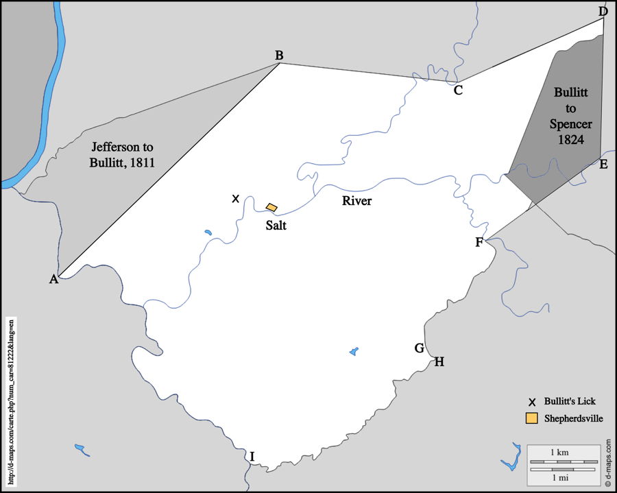
On 13 Dec 1796, the General Assembly passed an act to form a new county out of Jefferson and Nelson counties. The following paragraph is taken from that act. I have added letters within brackets to indicate where various identified points are located on the map shown here.
"Be it enacted by the General Assembly, That from and after the first day of January next, all that part of the counties of Jefferson and Nelson included in the following bounds to wit: [A] Beginning on Salt River opposite the mouth of Mill Creek thence a straight line to the [B] Elk Lick near William Chapman's, thence on a straight line to [C] Floyds fork where the public road from Louisville to Bardstown crosses the same at Hickman's, thence a direct line to [D] a point on the boundary line between Shelby county and the said County of Jefferson, seven miles northwardly of the mouth of Plumb creek thence with the said line to [E] Salt River at the mouth of Plumb creek thence with a straight line to the [F] mouth of the west fork of Coxe's creek thence up the same to [G] the head, thence to the [H] nearest waters of Wilson's creek thence down said creek to [I] its junction with the Rolling fork thence down the same to [J] Salt River thence down the same to the Beginning shall be one distinct county and called and known by the name of Bullitt."
So, on 1 Jan 1797, Bullitt County officially came into existence. It looked a bit different then. Its eastern and western borders which followed waterways were close to where they are today. The only point in that description that is uncertain is the location of the Elk Lick [point B]. I have selected a spot that seems reasonable for it, but at this time it is uncertain.
The county was named for Alexander Scott Bullitt, then president of the Kentucky Senate. Bullitt's Lick was named for his uncle Thomas Bullitt. Alexander would become the state's first Lieutenant Governor when that office was created in the 1799 Constitution.
The 1796 legislative act establishing the county had specified that the first meeting of the the justices of the peace was to be held at the home of Benjamin Summers. Another report suggests that it was held at Mose Moore's home. Regardless, they did meet, and selected Moses Moore as the county judge, Benjamin Summers as sheriff, and Thomas Speed as county clerk. They also chose Shepherdsville as the county seat.
This seems to have created a boom for the town. In 1797, lots were purchased by John Hughes (3), Thomas Brashear (2), Benjamin Summers (10), Daniel Wilson, Francis Blondell, James Brown (3), James Simpson (2), William de Rohan, Armsted Moorhead, James Lathem, Edward Frye, John Scott, Thomas McGee, John Collins, and John Moore (2).
The county gained a significant area from Jefferson County in 1811, and gave up a portion of its eastern land to the newly created Spencer County in 1824, as shown on the map; thus achieving its present shape.
Change would come. Other communities would develop. The railroad would bring changes, as would the Civil War itself. These early pioneers and civic leaders would hardly recognize what we have become. It kind of makes me wonder what succeeding generations will think of us.
Copyright 2015 by Charles Hartley, Shepherdsville KY. All rights are reserved. No part of the content of this page may be included in any format in any place without the written permission of the copyright holder.
The Bullitt County History Museum, a service of the Bullitt County Genealogical Society, is located in the county courthouse at 300 South Buckman Street (Highway 61) in Shepherdsville, Kentucky. The museum, along with its research room, is open 10 a.m. to 4 p.m. Monday through Friday. Saturday appointments are available by calling 502-921-0161 during our regular weekday hours. Admission is free. The museum, as part of the Bullitt County Genealogical Society, is a 501(c)3 tax exempt organization and is classified as a 509(a)2 public charity. Contributions and bequests are deductible under section 2055, 2106, or 2522 of the Internal Revenue Code. Page last modified: 13 Jan 2024 . Page URL: bullittcountyhistory.org/memories/creation.html